X Close

Digital Education team blog

Home

Ideas and reflections from UCL's Digital Education team

Menu

Augmenting our realities and working together

By Rod Digges, on 24 February 2015

Last year I had the opportunity to contribute to BASC2001 an interdisciplinary course looking at the world of objects, the stories they hold and how they are researched and represented.
Updating the materials for my contribution this year, part of which involves the different ways objects can be represented digitally, I came across a number of online tools that I thought it would be worth writting about, they demonstrate how much easier it’s becoming for those with no great technical expertise to create 3D models, Augmented Reality scenarios and also to collaborate in website design.

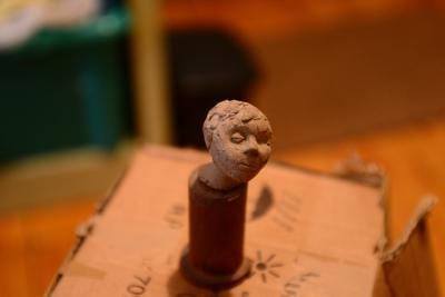
 The model above, a small maquette, made by a student at the Slade in the 1950’s was captured by simply taking a series of 25 photos and uploading these to http://apps.123dapp.com/catch/ a free cloud service that converts pictures into 3D models. The service provides an embed code that allows models to be placed in a web page but doesn’t allow annotation, https://sketchfab.com/ does, so the model files were re-uploaded there to provide the model shown above.

The creation of models like this is now a fairly simple task and once created newer online tools provide even more opportunities for the ways in which they can be represented; http://www.metaio.com/ has a downloadable Augmented Reality (AR) application (free for basic use) that allows models to be animated and viewed using ‘real world’ triggers like QR codes, images, or even locations.
By downloading an AR browser (from http://www.junaio.com/) to an Android or Apple mobile device these augmented realities can be viewed. If you’re interested in seeing for yourself, load the junaio browser onto your smartphone or tablet, scan the QR code below and then point it at the picture of the model below.

junaio_channel_378275_qrCode     Boy's head


As well as looking at ways of representing objects, students of BASC2001 have, in groups, to create a virtual exhibition of their allocated objects. While researching services that might help students with this task I came across https://cacoo.com – an online tool that allows users to simultaneously edit things like wireframe outlines for web sites – wireframing is a way laying out the essential structure of a website prior to ‘meat being put on the bones’, it’s an important step allowing teams to layout and discuss design decisions prior to committing to the work involved in realising a particular site.
One of the great features of the cacoo service is multiple editors can work simultaneously on the same page and view in realtime all the change that are being suggested. Another feature is that collaborators don’t need high level web design skills in order to contribute – an important consideration for students coming from a range of disciplines and having very different levels of digital literacy.
The ability to edit can be controlled by invitation only but, for the brave, layouts can set to be world editable like this one – https://cacoo.com/diagrams/Ubzjolw5T8HBAtTw


Guest Post – Dr Mat Disney on using Adobe Connect

By ccaalts, on 21 March 2011

Downtown Chicago, 10/4/2003 in ‘real’ colour (RGB)

Downtown Chicago, 10/4/2003 in ‘real’ colour (RGB) © 2011 GeoEye

from Dr Mat Disney

As a Lecturer in Remote Sensing in the Department of Geography I get to talk to (at?) students on a regular basis, something I enjoy. Over the past few years I’ve looked for opportunities to present my research to school students in a range of environments, something UCL encourages through our partnership with City and Islington Academy for example. I’ve spoken at workshops, schools, the Royal Society Summer Exhibition, as well as running hands-on practical sessions and writing about what I do for school science publications (see SEP’s Catalyst for example). It doesn’t hurt that my research is very visual – satellite images, 3D models and animations, fires, trees and so on.

Recently I had the opportunity to talk about remote sensing to high-school students from under-served communities in Chicago as part of a programme to introduce real-world applications of science, technology, engineering and maths (STEM) outside their normal curriculum. The students voluntarily attend sessions for three hours on Saturday mornings and interact in real-time via video, interactive whiteboards and instant messaging using Adobe Connect.

Mat Disney using Adobe Connect

Screenshot of the session using Adobe Connect

The Chicago session was co-organised by Ian Usher, a former UCL Geography colleague who is now e-learning co-ordinator for Bucks County Council, and Roxana Hadad in Chicago. I showed the students various satellite images, including some striking high resolution satellite images of downtown Chicago, the Mall in Washington DC showing a large rally that took place in late October, and Stonehenge, and discussed with them what their environmental and scientific applications might be.

I was very impressed with the level of interaction provided by the software – me in my garden office at home, and them in a well-equipped classroom half a world away. I was even more impressed by how enthusiastic and welcoming the students were. They were very quick to work out what they were looking at – for example the dried up river system around Stonehenge, along with the context and significance. They very rapidly arrived at the idea that Stonehenge might be a prehistoric calendar of sorts.

Landsat image of Chicago, 10/4/2003 displayed in false colour (near infrared, red, green)

Chicago, 10/4/2003 in false colour (near infrared, red, green) © 2011 GeoEye

I think the novelty of being able to interact so directly and immediately with students outside their normal sphere like this is a really powerful way of attracting and maintaining interest. The advances in bandwidth and software tools allow for rich two-way interaction which brings the whole process alive (compared to web-based delivery of video for example). It was a very enjoyable experience, and I really look forward to more activities like this – it’s a great way help bring UCL’s expertise to a wider audience.

This is a further follow up to a brief report by UCL News in January

Etherpad – a gem of a tool for collaborative writing

By Fiona Strawbridge, on 9 March 2010

Steve Rowett has just introduced us to Etherpad – an online tool for collaborative writing.  You can find it at http://etherpad.com/ and using it is beautifully simple:  You simply click on the ‘Create public pad’ and start writing.

Of course, being collaborative you would want to invite others to work with you, so the first thing to do in the ‘Public Pad’ view is to invite others to join you.  I sent out an invitation to colleagues at 11.45, suggesting we start working together at noon.  One by one people showed up, within moments had worked out how to identify themselves, and how to use the chat as well as the editing interface, and 15 minutes later we had created a reasonable document.  You can see who is writing what as all text is colour coded by author.

Fabulous for brainstorming. Beats the wiki hands down. Also beats GoogleDocs as the refresh time is just 0.5 seconds compared with 15 secs for Google.  Etherpad explain that they are able to do this because ‘it’s really, really hard. We’re fairly experienced programmers, and to make this work we had to solve problems that, as far as we know, no one had solved before.’

It also has a timeline feature so that you can go back through the entire document simply by sliding a slider across the screen. Lovely!

Here’s a quick (and slightly rough around the edges) video to show it in action.