X Close

The Bartlett Development Planning Unit

Home

Collective reflections about development practice and cities

Menu

Land security through food security

By Pamela Hartley-Pinto, on 31 August 2023

What would land security for urban informal settlement residents look like if the state prioritised, and rewarded, food sovereignty and security instead of automatically turning first to questions of land tenure and property rights? This question is a provocation to think land security for marginalised groups anew, and simultaneously address a key dimension of food and nutrition in concerns for social protection.

When the state talks about land and addressing insecurity of residents in informal settlements, the first issues they reach for are always tenure and property rights. This is because the framing of land as a commodity within the interaction of supply and demand is so prevalent. However, there are other ways of considering land and food systems which could also form the basis for a contract between the state and residents in informal settlements so that food security could become a guarantee for land security.

Status quo of land use management

It has already been established that “clear and secure land tenure can improve livelihoods and sustainable management of natural resources, including forests, and promote sustainable development and responsible investment that eradicates poverty and food insecurity (Mennen, 2015).” UN SDGs talk about “access to ownership and control over land and other forms of property” as well as “including secure and equal access to land.” Despite this and the evidence around benefits of secure land tenure, governments dither, but rethinking it from a food security perspective could open new avenues

When flipping the order of things and re-prioritizing, putting food security first could lead to land tenure for those providing the food, taking care of the community gardens and looking after the produce, as well as act as a quantifiable alternative to social protection reducing the burden on the state. As Li puts it, the meaning given to land varies depending on who you are asking and as well as the “materiality” and the “inscription devices define what type of resource land is (Li, 2014).” Also, “land tenure has usually been viewed as a supply-side’ issue, while food security has been considered a `demand-side’ issue (Maxwell and Wiebe, 1999).” Having this distinction in mind and rethinking the relationship between food security and land tenure has the potential to flip the politics of the discourse and the relations of power within the territories, in fact giving other actors who have a stake in the discourse a seat at the table. Empowered and organised communities or coalitions could use a new narrative when referring to the land they take care of and shift the supply and demand logic.


Peru and food insecurity

Drawing on the example of contemporary Peruvian food security: data from the Food and Agriculture Organization states that over 51% of the population is living in moderate food insecurity, meaning that “people have reduced the quality of their diet or are eating less than they need (FAO, 2022).” Exploring the links between land tenure and food security, Maxwell and Wiebe highlight how “access to food derives from opportunities to produce food directly or to exchange other commodities or services for food (Maxwell and Wiebe, 1999).”

Currently, the Peruvian government has a variety of social programmes tackling food insecurity but none of them address the root of the problem. The programmes established now include food handouts, cash transfers or government-sponsored soup kitchens with little to no capacity building. What would other strategies to tackle food insecurity look like? Perhaps involving communities themselves and supporting co-produced solutions to move away from a top-down welfare practice to a bottom-up coalition of government and non-government actors.


Working with informality

Acknowledging and rewarding the existence of established community networks, artisanal risk prevention and natural disaster management from the grassroots as well as community-led soup kitchens should be taken seriously as solid examples of community infrastructures and human and social capital (Moser, 1998). Reframing these assets into food security and governance is just a matter of recognising and working with informality rather than punishing it.

Collaborative bottom-up strategies through their “invented spaces of citizenship” (Miraftab, 2004) fight exclusion and aim to support local collective action for survival whilst ensuring food security for the communities they serve. Seeing that these initiatives at the grassroots are working well, why not add additional government support in the form of land for community gardens specifically for those community soup kitchens that are already mapped and established?

Overall, considering the materiality of land, there could be “an expanded capacity to envision underutilised land as a globally important asset capable of producing food, profits, and a reduction of poverty as well (Li, 2014).”

In conclusion, the question of refocusing on food security and sovereignty as the starting point for land urban security as well as looking at it as an alternative to current social protection policies changes priorities. It gives a strengthened platform to insurgent planners and bottom-up community-led strategies of survival while promoting ownership and a sound alternative to the state’s responsibility to its citizens regarding social protection.

Community-led soup kitchen-Absalon Alarcon in Lima, Peru (Photo: TECHO Peru)


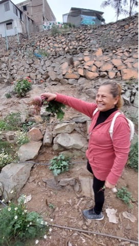
Maria, community leader, holding produce from her urban community garden (photo: TECHO Peru)


References

Li, T.M. (2014) “What is land? assembling a resource for Global Investment,” Transactions of the Institute of British Geographers, 39(4), pp. 589–602. Available at: https://doi.org/10.1111/tran.12065.

Maxwell, D. and Wiebe, K. (1999) “Land tenure and Food Security: Exploring Dynamic Linkages,” Development and Change, 30(4), pp. 825–849. Available at: https://doi.org/10.1111/1467-7660.00139.

Mennen, T. (2017) Know your SDGS: Land matters for sustainable development, Chemonics International. Available at: https://chemonics.com/blog/know-your-sdgs-land-matters-for-sustainable-development/ (Accessed: January 8, 2023).

Miraftab, F. (2004) Invited and Invented Spaces of Participation: Neoliberal Citizenship and Feminists’ Expanded Notion of Politics. Wagadu: Journal of Transnational Women’s and Gender Studies. (e journal). http://appweb.cortland.edu/ojs/index.php/Wagadu

Moser, C.O.N. (1998) “The asset vulnerability framework: Reassessing urban poverty reduction strategies,” World Development, 26(1), pp. 1–19. Available at: https://doi.org/10.1016/s0305-750x(97)10015-8.

Peru’s food crisis grows amid soaring prices and poverty: FAO | UN News (2022) United Nations. United Nations. Available at: https://news.un.org/en/story/2022/11/1130737#:~:text=According%20to%20a%202021%20 FAO, eating%20less%20than%20they%20need.%E2%80%9D (Accessed: January 6, 2023).

How and in what ways can local-level risk information about health and disasters influence city government practices and policies?

By Cassidy A Johnson, on 28 February 2019

This blog is the fourth of the health in urban development blog series. View also:

Treat, contain, repeat: key links between water supply, sanitation and urban health
By Pascale Hofmann

Health in secondary urban centres: Insights from Karonga, Malawi
By Don Brown

Gaza: Cage Politics, Violence and Health
By Haim Yacobi


If you are interested in DPU’s new MSc in Health in Urban Development, more information can be found on our website.


Over the last few years there have been several initiatives to develop practical and policy-relevant ways to measure environmental risks faced by low-income groups. This has been in response to a severe lack of information about disaster and health risks available for policy makers to draw on in most low- and middle-income nations. There is a need for both detailed settlement-level data, particularly for informal settlements, as well as for aggregated data needed to inform city-level or national interventions[i]. In this blog, I discuss innovative methodologies that are being developed in cities of the Global South to generate much needed data for action.

Innovative methodologies for understanding health and disaster risks at the urban scale

Innovative methods developed for understanding and measuring these risks range from profiling and mapping informal settlements with community-led or co-production approaches, to detailed analysis of hospital, police and newspaper records. Other methods seek to build consensus based on perceptions and experiences of risk with communities and local governments. DesInventar is a collection of national, regional and city-level databases, which use newspaper reports, as well as police, hospital and accident records to create a detailed portrait of both large or intensive disasters and small-scale extensive disaster events. Other methodologies such as Slum/Shack Dwellers International (SDI) settlement profiling and Action at the Frontline use community-generated information about resident’s experiences of health and disaster risks in order to enter into dialogue with municipal governments about their needs. ReMapRisk uses community-generated risk information and offers a spatial analysis with maps to interrogate and visualise the information, there are maps for Lima (Peru), Karonga (Malawi) and Freetown (Sierra Leone).  Other approaches, such CityRAP, The City Resilience Index and 10 Essentials for Making Cities Resilient focus on the municipal government’s perspectives of risks and capacities for addressing risk at the city-level, and often in dialogue with communities.


Health and disaster risks faced by the urban poor

These studies have found that women, men and children living in informal settlements are disproportionally exposed to small and large-scale disaster risks such as flooding, landslides and fires, as well as everyday risks, such as water borne illnesses and poor air quality. For example, the AXA-funded research I have been involved in in Dar es Salaam in Tanzania, used Action at the Frontline methodology, with household surveys, focus groups and action planning Mtambani settlement in Ilala municipality and Bonde la Mpunga settlement in Kinondoni municipality[ii]. The communities identified crime, poor solid management, lack of storm-water drainage infrastructure, lack of wastewater and toilet infrastructure, lack of basic health services and hospitals, flooding, high living costs and drug abuse as the main issues in their settlements. Many of these are directly related to health problems, such as malaria, diarrheal disease and personal safety. While big disasters, such a major floods, earthquakes, tsunami and windstorms do affect the health and welfare of millions across the globe every year, it is actually the smaller events and everyday risks that impact the greatest number of people’s health and well-being.


These different methods of understanding risks have been employed in close partnerships between researchers, community organisations, municipal authorities and other research users in many cities across Asia, Africa and Latin America. While there are many innovative initiatives for understanding and measuring risks, the data still remains extremely patchy and limited in scope. Furthermore, and its uptake into municipal government operations and planning is not guaranteed.


Principles for the uptake of risk information in urban planning and policy making

Through the Urban Africa Risk Knowledge programme[iii], researchers have identified some principles related to the uptake of local-level risk information into planning and policy making: 1) It is important not just to provide the type of information that are assumed to be useful, but to work closely with partners in identifying data that will be useful for policy and practice[iv]. 2) The community-driven process can be more conducive to driving change in practice and policy in local government than expert-driven data. The use of local knowledge that comes through communities collaborating with local level decision-makers can capture the qualitative experiences of risks and measure the burdens arising from these risks, while enabling communities to engage with local governments/state about their needs[v]. 3) Small steps at collecting local data that are ‘good-enough’ can be valuable in the beginning.[vi] 4) Project-based risk measurement initiatives are rarely enough to make a difference in government practices and policies. What is required is long-term and sustained engagement with information that is regularly updated. 5) Improving official data collection, such as census, vital registration systems and healthcare records will be necessary to systematically address disaster and health risks in informal settlements[vii].


Many cities in low- and middle- income countries, and especially in sub-Saharan Africa, do not have functioning local governments, they lack a metropolitan structure or their resources are too meagre to take on new initiatives. While some progress has been made in developing methodologies that help us to better understand the everyday and small-scale disaster risks that underpin women’s, men’s and children’s health in informal settlement, there is still much more to do to scale up these initiatives and to enable local governments to take actions to address risks.


References

[i] Satterthwaite, D and Sverdlik, A (2018). Assessing health risks in informal settlements in sub-Saharan African cities. Urban Africa Risk Knowledge Briefing, No. 10. June 2018. Available from: https://www.urbanark.org/assessing-health-risks-informal-settlements-sub-saharan-african-cities

[ii] Osuteye, E. at al. (2018). Communicating risk from the frontline: projecting community voices into disaster risk management policies across scales. Urban Africa Risk Knowledge Briefing, No. 19. October 2018. Available from:

[iii] See www.urbanark.org

[iv] Dodman, D., Leck, H. and F. Taylor (2017). Applying multiple methods to understand and address urban risk. Urban Africa Risk Knowledge Briefing, No. 7. July 2017. Available from: https://www.urbanark.org/applying-multiple-methods-understand-and-address-urban-risk

[v] Osuteye, E. at al. (2018). Communicating risk from the frontline: projecting community voices into disaster risk management policies across scales. Urban Africa Risk Knowledge Briefing, No. 19. October 2018. Available from: https://www.urbanark.org/communicating-risk-frontline-projecting-community-voices-disaster-risk-management-policies-across

[vi] Spaliviero, M. at al. (2019). Urban Resilience building in fast-growing African Cities. Urban Africa Risk Knowledge Briefing, No. 20, January 2019. Available from: https://www.urbanark.org/urban-resilience-building-fast-growing-african-cities

[vii][vii] Adelekan, I.O. and D. Satterthwaite (2019). Filling the data gaps on everyday and disaster risks in cities: The case of Ibadan. Urban Africa Risk Knowledge Briefing, No 22. January 2019. Available from: https://www.urbanark.org/filling-data-gaps-every-day-and-disaster-risks-cities-case-ibadan

The Amazonian city in Peru at crossroads

By Giovanna Astolfo, on 3 August 2017

The contemporary urbanisation of Amazonas is a geopolitical creation, and a recent phenomenon. For long time native communities have been living in sparse, often isolated, settlements. Adapting to the mutable conditions of the river, they created a system based on mobility, economic diversification and ‘multi-sited territorial appropriation’ (Peluso and Alexiadis, 2016). Such use and production of space was and still is disarticulated from any single master principle of spatial organization and from usual dichotomies such as rural/urban and public/private. Starting from the 1960s, extractive activities favoured rural-urban migration. Cities such Iquitos, Tarapoto and Puerto Maldonado in Peru, Leticia in Colombia, Belem and Manaus in Brazil grew immensely in few decades. Rural population moved to the cities, settling along the river, often retaining the traditional spatial organisation. Their survival is now threatened by climate change and flooding risk, coupled with recession and growing unemployment following the recent decline of oil extraction. Exploitation of resources prevented the growth of productive activities offering now little alternative sources of income to the urban population.

Photo credit CASA

Photo credit CASA


It is in this complex context that the research project Ciudades Auto-Sostenibles Amazónicas (CASA), led by Pablo Vega-Centeno at Pontificia Universidad Católica del Perú (PUCP), and coordinated by the BUDD alumna Belén Desmaison (PUCP), with the involvement of DPU’s Camillo Boano and Giovanna Astolfo, is developing a participatory process with local communities, local authorities and the national government to co-produce sustainable spatialities and promote alternative livelihoods systems in the Amazonas, starting from local technologies and knowledges. The project aims to create evidence-based methodology for a more participatory implementation process of preventive relocations. The project looks at the city of Iquitos, in the Peruvian Amazon, where a massive relocation process of around 16,000 people living in the flood-prone low-district of Belén is undergoing amid great difficulties and resistance. The government-led relocation has been implemented following a DRM policy released in 2011 and as part of the national programme “Programa Nuestras Ciudades”; despite many positive pioneering aspects, the decision-making process was centralised and the project poorly articulated, failing to capture the socio-spatial complexity of the context. Particularly, the relocation threatens the traditional spatial organisation of Amazon’s communities, negatively impacting the livelihoods system.


Photo credit CASA

Photo credit CASA


Approximately 200 families have been relocated to date. However, the decision whether to move or not is creating tensions and conflicts amongst the remaining groups, as highlighted in earlier research conducted by the Facultad Latinoamericana de Ciencias Sociales (FLACSO) as part of the research “Reducing Relocation Risk in Urban Areas” led by Cassidy Johnson at DPU.  If, on one side, relocation can improve health condition and security, on the other side it might result in greater impoverishment consequent to the loss of jobs and traditional ways of living. Currently, most of the population is against relocation. Lack of trust in the process, and the polarisation of political parties are poisoning the debate (Chavez, 2016). Understandably enough, relocation is, above all, a matter of the narrative that is created around it.

Connected through a newly constructed road, Nuevo Belén is distant from the city of Iquitos, and from the Amazon River and its tributaries which are the main source of income. It is an artificial city that looks like a dorm, as few of the planned facilities have been built so far. Each family has been given a lot of around 120 sq.mt., out of which 40 are occupied by the house. The housing typology is far from reflecting the social organisation and the constructive tradition, let aside being suitable to the climate. Reason why most of the dwellers have already transformed the space. Shelters on stilts are popping up where the ‘gardens’ should be, while the concrete houses serve as shops. Productive spaces (‘huertas’) are mushrooming around the houses as a consequence of informal appropriation of land, although under temporary deals – as the land will be soon occupied by the second round of housing construction.


Photo credit CASA

Photo credit CASA


Starting from the ‘huertas’, the workshop that took place in July in Nuevo Belén focused on alternative design proposals for the creation of self-sufficient systems to ensure the economic sustainability of resettlement, and to create new livelihoods options. Proposals, developed by an interdisciplinary team of PUCP students and validated by the community, investigate what technologies and construction techniques are better adaptable to the context in social, spatial and climatic terms (particularly related to solar energy and rain collection).


Photo credit CASA

Photo credit CASA


Clearly, Amazonian cities posit great challenges, particularly to those communities affected by economic recession, settled on flood-prone areas and at risk of relocation. It is necessary to think a different urbanisation, flexible, adaptive and temporal, more similar to the tradition of disperse settlement of the native communities. Relocation should be conceptualised as an urbanism in flux characterised by interconnected mobilities and heterogeneity (Browder and Godfrey, 1997); and its open spaces should not be purely private nor merely public and should be understood as in-between spaces, reproduced through mobility that is constitutive of this urbanity in flux.


Photo credit CASA

Photo credit CASA


DPU’s Camillo Boano and Giovanna Astolfo are involved in the research project Ciudades Auto-Sostenibles Amazónicas (CASA) that looks at the Amazonian city of Iquitos. The project is led by Pablo Vega-Centeno of the Centro de Investigación, Arquitectura y Ciudad (CIAC), Pontificia Universidad Católica del Perú (PUCP), and coordinated by Belén Desmaison (PUCP and DPU alumna). As part of the project, in July Giovanna Astolfo participated to the workshop ‘Taller Partecipativo’ in Nuevo Belen with CASA team and students from PUCP.

https://casapucp.com/

CASA is part of the CRC Initiative funded by CDKN, IRDC and FFLA. https://crclatam.net/

The field research – Learnings beyond the research itself

By ucfuarl, on 7 July 2017

While only lasting for a few weeks, the field research trip is an intense experience that provides in-depth learnings that go beyond the research outcomes themselves. One of the key highlights for me was how a good field research technique is about combining learnings from human interactions as well as using planning and organisational tools to reduce the uncertainty that surrounds field research.

Part 1: Learnings from the people – Disillusionment in the periphery

View from the community of Villa Lourdes Ecológico (VMT)

I’m standing here on the dark distant slopes of Villa Lourdes Ecológico, a settlement without water, sewerage or electricity access, looking down at the city of Lima that stretches as far as the eye can see. We have just had a focus group using headtorches with a group of mostly women, their kids playing at their feet. They came to meet us with hope, a hope to be listened to. They feel forgotten and right here, in this dark spot, I can relate to this disillusionment.

Since arriving in Lima, I have heard many heartfelt sentences from people who have lost hope and no longer believe in the transformative change we came here to seek. Vicente Chavez, a leader of the fog catcher initiative from this community, wants to move back to Cusco instead of “waiting here, hoping for the water to come from the sky”.

A few days before, at a march on water access, I came across the slogan “stop fighting is to start dying”. Whilst extreme for effect, I do believe that when people feel disheartened about their situation, they stop engaging and driving change.


Without pressure on decision makers, they may well be forgotten.

I can already observe the direct negative impact of the lack of hope. With the fog catchers project, people lost hope in official support and decreased engagement to the point that they were not making use of a solution that was already available to them. Some community members did not even know that they were entitled to a piece of land to cultivate using water from the fog catchers.

And yet, people’s support and buy-in are rarely mentioned in policy briefs as a key prerequisite to foster participation. It appears critical that our recommendations consider how to help restore people’s hope in the potential for transformative change in order to ultimately foster their participation and make them instrumental in their future.

Two crucial factors to regain this confidence from the people: transparency and action. Communities explicitly asked for “no more lies” about their situation. They need to understand better the short to long term plans to organise and decide accordingly. Not knowing often means that they linger in the fear of taking action that could damage their current situation. They also need to “see proofs” that improvements are made whether in the form of electricity access or small-scale infrastructure work such as stairs. When projects reach their community, people feel heard and that change is possible thereby increasing their likeliness to engage.

This gave me an additional purpose and some guidance for our research. As future planners, we have the duty not only to bring to light these forgotten realities but to also deliver recommendations that aim at overcoming people’s disillusionment when requiring their participation. In other words, the role of a socio-environmental planner is to make sure that no one is left out in the dark without hope.

Water march board

Part 2 – Learnings from the process – Networking, my ally for achieving holistic research

As Lima was my first field research trip I was aware that data collection would be the most challenging phase of the research process. As a project manager, I am used to things being planned from A to Z before a project even starts. As a result, I was fearing data collection as I viewed it as uncertain and unpredictable. Thankfully, I discovered a great ally that changed my perspective and allowed us to bring structure to data collection: networking.

I understand networking as interactions with a system of interrelated primary and secondary connections that hold different roles, views and power about a given topic. To have a holistic data gathering, it is important to network with a diverse range of actors of various opinions. However, not all stakeholders play the same role in data collection. In the field, when time is limited, it is vital to be flexible and to learn to also rely on secondary connections. While they may provide a smaller share of information, these connections can be more engaged and transparent. In our case, we met with an engineer working on the ecosanitation project from Sedapal who could be considered as a secondary connection given his operational clout in the project. His insights, provided anonymously, proved even deeper than information provided by the key project partner AguaEcosan.

Having recognised the importance of networking, it became critical to integrate it in our research process as a key planning tool for data collection. Recognising that these connections may not always happen organically, it is important to have the methods in place to foster networking and adapt it constantly in the field. Clear research objectives and actor-mapping were critical to  framing our networking. By knowing the data we needed, the current gaps and the existing actors we could interact with, it became easier to prioritise connections and make the required substitutions when needed, understanding the implications for our research.

Actors mapping

The role of networking as a planning tool for data collection was critical in achieving our research objective to understand better the eschemas model, a publicly-driven city-wide framework from Sedapal to provide water and sanitation services to 100% of the population. Making a direct connection within Sedapal had not yielded any result so we mapped potential actors that could help us gather similar data and decided to network upwards from the communities. We leveraged our existing relationship with the NGO Peruanos sin Agua to connect with a leader from an eschema committee at a water protest march. While the march itself had little importance from a data collection perspective, the contact had the potential to be the missing link we needed to connect with Sedapal as the march was organised in collaboration with the worker union from Sedapal. This allowed us to achieve our initial research goal.

First, these key learnings about the methods to network efficiently allowed me to overcome my fear of data collection by understanding that data collection can be planned and is not as uncertain as I saw it originally. Furthermore, recognising the existence of this system of interrelated primary and secondary connections enabled me to use networking as a key ally to engage with these connections and collect data in a holistic and efficient way. Ultimately, this ultimately has a positive impact on the quality of our research outcomes.


Conclusion

It is undeniable that pre-research plays a key role in research trips as it allows to gain deep knowledge about a given field of analysis and form initial hypotheses to verify during the research. However, once on the ground, the reality can challenge assumptions and reshape priorities… but after all, research is about ‘trusting the process’. While tools such as networking should be used to help reduce uncertainty, planners should remain flexible and embrace the research journey to gather findings that go much beyond pure research outcomes.


Florie Arlegui is a product strategy lead studying for a MSc Environment & Sustainable Development as a part-time student (2015-2017) in order to pursue a career change. She is particularly passionate about sustainable mobility in cities.

Learning about urban risk

By ucfuadr, on 11 August 2016

Originally published by CDKN

Different forms of rational and experiential knowledge underpin the way we learn about the city; the way we discern where is safe and unsafe, what is just and unjust, and what realities – as well as whose – coexist in its everyday life. As argued by Colin McFarlane in Learning the City, this knowledge of the city is not something that urbanites either possess or lack. Rather, it emerges from the process of making sense of the city, in which urban dwellers reproduce or contest data and information, as well as beliefs, discourses and practices. Furthermore, the learning process is not completely internal to individual women and men, but rather shaped and reshaped by multiple interactions with other people, places, stories, images and imaginations.

This is the first of two interlinked articles that reflect on the insights on public learning gained through the action-research project cLIMA sin Riesgo. Focusing on Lima, the world’s second largest desert metropolis, the project explores the conditions that produce and reproduce vicious risk accumulation cycles, or ‘urban risk traps.’ It looks at how and where risk traps materialise, and with what consequences for women and men living in two contrasting areas: Barrios Altos, located in the historic city of Lima, and José Carlos Mariátegui, situated in the poorest and most densely populated district in the periphery of the city (Allen et al, 2015). In these areas, most local dwellers live in conditions of poverty, marginalisation and high vulnerability to everyday risks and small-scale episodic disasters. In 2015, both areas were among those declared under emergency due to the forecasted impacts of the warm phase of El Niño Southern Oscillation (ENSO). The ENSO cycle – both El Niño and La Niña – causes global changes in temperatures and rainfall, which for local residents means worsening everyday risks and episodic disasters threatening human life and wellbeing, as well as man-made and ecological infrastructure.

Figure 1: Living in risk in the centre and Figure 2 (below) Living in risk in the periphery of Lima

Figure 1: Living in risk in the centre and Figure 2 (below) Living in risk in the periphery of Lima

The project approaches ‘public learning’ as a means to reframe the way in which everyday risk is perceived, experienced and addressed, in order to promote concerted and strategic interventions to build just urban resilience. This piece reflects on how such learning can be deepened when those directly exposed to everyday risks participate in mapping and surveying their own neighbourhoods (Lambert and Poblet, 2016).

Learning from the barrio: From research beneficiaries to knowledge producers

Learning about urban risk is a complex process, requiring individuals to anticipate potential dangers before they occur. Furthermore, while many urbanites might be aware of the potential threats of large-scale events such as earthquakes, the risks underpinning the everyday lives of marginalised people often go unseen. Paradoxically, the experience of everyday risks is often invisible to those who are most exposed to them, and thus internalised as something that is part of life. This is the case for instance, when local dwellers believe that living without water and sanitation or negotiating their everyday life through the steep slopes is part of the price they have to pay to remain in the city. cLIMA sin Riesgo starts from the assumption that everyday risks need to be learnt spatially both by those who experience them and those who aim to address them. This requires the inclusion of the lived experiences, exposure and perceptions of those who are most vulnerable to them at the scale of the neighbourhood (‘barrio‘) and the household. Between July and November 2015, the team conducted a comprehensive participatory survey that covered 700 households – about a third of the total households found in 12 informal settlements in José Carlos Mariátegui and in the rented multi-family housing units (‘quintas’) of Barrios Altos.

Local women and men joined a research team combing the neighbourhoods through the application of a geo-referenced questionnaire. Using accessible smartphone technologies such as Epicollect+[i], they gathered data on types of risks affecting dwellers in each area, what makes some households more vulnerable than others and how people respond to these conditions to cope, mitigate or prevent actual and potential impacts. The survey offered insight into the capacities of local dwellers to act individually, collectively and with external organisations. The process allowed those taking part in the survey – both as interviewers and interviewees – to make sense of common experiences but also different realities confronting people in the same area. Furthermore, zooming into the household and out into the wider scales’ of each area and the city revealed many of the processes and actions that produce and reproduce risk traps.

Figure 2: Testimony from a woman participating in the survey in José Carlos Mariátegui: “We worry about the settlement, but we are not always aware of what happens behind our back… With the drones[ii] we were able to understand how land traffickers are operating in the area”

Figure 2: Testimony from a woman participating in the survey in José Carlos Mariátegui: “We worry about the settlement, but we are not always aware of what happens behind our back… With the drones[ii] we were able to understand how land traffickers are operating in the area”

In Barrios Altos, for instance, we recorded the quiet process by which many of the multi-family structures that are part of the cultural heritage of the city are being turned into warehouses that store heavy containers that often provoke the collapse of buildings. We also captured the process of quiet eviction in which pipes are intentionally broken to make dwelling impossible, thus forcing tenants out of the quintas and making it possible to demolish and redevelop the area for more lucrative and speculative purposes.

In José Carlos Mariátegui, zooming from the level of the household and local community (‘Agrupación Familiar’) into the wider political geography of the settlements’ slopes revealed how urban risk traps are exacerbated by the actions of land traffickers who, through the illegal appropriation and sale of land, urbanise the upper areas of the slopes, resulting in frequent rockslides and landslides that affect those living below.

It is said that ‘we live and learn’, but can we reframe our learning of the experiences of others, faraway from our own everyday lives? A follow up piece (coming soon) will reflect on this question and on how public learning might reveal the unseen, helping us to learn urban risk beyond our lived experiences and to be part of transformative change.

To learn more about the project, or to expand the ongoing learning process to other cities, please register on the bilingual website of the project at www.climasinriesgonet and/or contact:

Figure 3: Participatory mapping process in the centre of the city

Figure 3: Participatory mapping process in the centre of the city

[i]Epicollect + is an open source smartphone application that enables the design of surveys and the georeferenced data gathering and its transferal onto GIS.

[ii] Drones are remote controlled airborne devices with cameras capturing up-to-date images. Although there is controversy about their application, if used sensitively, they can help advance the visualisation of typically disregarded realities. In ReMapLima, a project that preceded cLIMa sin Riesgo, drones were used to generate up-to-date images of both settlements which were later used as a cartographic base to geo-referenced the data gathered through the mapping process.

Conducting Research in the Context of Evictions in Lima, Peru

By zcfag19, on 27 January 2015

Children in Cantagallo. Image: Loan Diep

The MSc Environment and Sustainable Development at the DPU is currently involved in a multi-year project of overseas field research in Lima, Peru. I was part of this project last year and worked in Cantagallo, a small area close to the centre of the city. My team’s initial plan was to explore the way the construction of a transport megaproject was affecting people working and living in Cantagallo. However, unexpected events occurred during our presence there, and they profoundly changed the situation. The megaproject was evolving more rapidly than expected and a relocation process of the population started in fundamentally different ways than officially announced.

While several families had accepted this and begun to clear their plots in exchange for a controversially low amount of compensation, others were trying to resist and negotiate the terms of their relocation with the authorities. Many families were evicted without an acceptable agreement made, if any at all. However, as the video below attempts to illustrate, the situation differs from one case to another because Cantagallo has been inhabited by families with different histories, and thus, different rights according to the law. This diversity has added to the complexity of the situation: in some cases it has created conflicts within the communities and also hampered possibilities for negotiation with the authorities.

On our first visit to Cantagallo, teenagers were playing football in a large circular area at the entrance to the neighbourhood. On our third visit, the landscape had literally changed within a few days: all trees were being uprooted and little temporary houses had started to mushroom in this same football pitch. We were witnessing the eviction of some and relocation of others. We knew we held no power to make a significant change. I remember the sense of panic that invaded our research group when we realised there was little chance we could realistically and positively contribute to the situation. But there was work to do and opportunities to explore.

We decided to capture the complexities of Cantagallo, understand its intricacies and explore the injustices that have been produced and reproduced over time. Some people had already been evicted in the past and were about to experience the same again. We interviewed them to hear their stories. Despite the events, many people came to the workshop we organised there. More significantly, many people from different parts of Cantagallo came to our final presentation to hear what we had to say. It was really unexpected but they all came to listen, to comment and to discuss.

Most importantly, they did it together. This big communication gap that we had observed and thought was hampering progress in negotiations was being bridged in front of us. This gave me hope that they could jointly engage with the authorities over the following weeks. Today (eight months later), I know the people of Cantagallo have not been able to resist the megaproject despite their collaborative efforts. However, I deeply hope that our work has provided them with some grounds to break the continuing cycle of eviction in Lima.


Loan Diep is graduate from the MSc Environment and Sustainable Development at the DPU in 2014. Her academic background is in both natural and political sciences; she has degrees in Health, Safety and Environment (University of Caen, France) and a BSc in Environment Geography (UCL). Loan is currently working as a consultant for IIED (International Institute for Environment and Development) and as a research intern at WSUP (Water and Sanitation for the Urban Poor). She is also a Bartlett Ambassador for the period 2014-2017. Her interests lie in environmental politics, climate change, water & sanitation in the Global South.

Read more about the MSc Environment and Sustainable Development overseas fieldtrips.