X Close

The Bartlett Development Planning Unit

Home

Collective reflections about development practice and cities

Menu

Exploring the public role of a Global University: Reflecting on the potential of embedded learning alliances in promoting planning justice

By Debayan Chatterjee, on 15 August 2023

Authors: Chauncie Bigler, Yuka Aota, Debayan Chatterjee, Corin Menuge (Graduates of MSc Urban Development Planning, Bartlett DPU, UCL)

Introduction

In the Autumn of 2019, a group of MSc Urban Development Planning students partnered with community groups in London’s Old Kent Road (/OKR) Neighbourhood to explore the potential of social audits as a tool for just urban transformation in the city. As part of the multi-year teaching partnership, our group had a specific objective of collaboratively designing a social audit tool with local community groups in OKR area. The purpose of this exercise was to both test the concept of social audits in London planning whilst also supporting community groups in the gathering of data on neighbourhood assets that held significant value for locals. At that time, interrupting the speculative real estate development planned for what had become a London ‘Opportunity Area’ (See Figure 1) was a key priority for the long-term residents, businesses and other groups in the area.

In July of 2021, almost two years later, we reached out to a highly-engaged community resident who had been involved in the 2019 engagement. Our intention was to ascertain whether the social auditing toolkit we had designed was still in use and, if possible, to compare its application in both a pre-pandemic and mid-pandemic context. This resident explained that the pandemic had sharpened the priorities of community organisers and those demanding more participatory development across London: “What we want is a plan B, in light of these huge changes in the last 18 months. We want a realistic appraisal of where things are at for the people who live here” (Community resident, 21 Aug 2021).

This experience of revisiting our research partnership after two years–and a global pandemic–later caused our group to reflect further on both our positionality as researchers and practitioners, and the role that academic partnerships such as ours may have in relation to the underlying goal to leave lasting and positive community impacts. Mere months after coproducing research with community activists – the COVID-19 pandemic shifted the ground upon which priorities and strategies would be developed.  As is common with planning praxis, all parties active in fighting for just planning in London, or globally, needed to reflect and react in order to move forward in highly changeable circumstances. Learning alliances such as the one we were engaged in must adapt, even in a global pandemic.

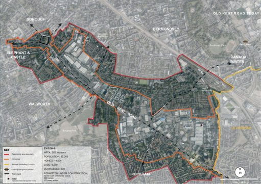
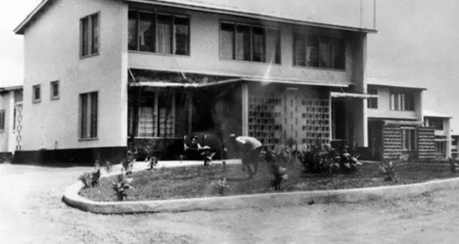
Figure 1: Old Kent Road opportunity area (Source: Southwark Council)

Revisiting Prior Engagement

Revisiting our study, the local groups see the multidimensional barriers of realising meaningful participation in planning. Many scholars (Fainstein, 2010; Healey, 2005) have tried to improve the UK’s institutionalised public participation system by highlighting the potential of a collaborative approach in planning and local governance. However, communities have continued to face difficulties in reflecting their insights on the OKR regeneration plan, such as when they could not attend in-person consultations due to COVID-19 pandemic impacts. Thus, this situation can lead to dominant decision-making over a particular plan (Arnstein, 1969). Community participation requires both Invited and Invented spaces (Miraftab, 2004). Invited spaces involve local authorities engaging with and integrating diverse perspectives during the initial phases of planning, acknowledging the value of individuals’ insights and experiences as future end-users (Ball, 2004). However, effective community participation also demands autonomous, Invented spaces for community knowledge development and counter-planning. Indeed the two should work iteratively.

Just Space, an informal alliance comprising approximately 80 community groups, is dedicated to amplifying local voices and perspectives from grassroots levels up to London’s major planning strategies. In their “Community-Led Plan for London” (Just Space, 2013), the alliance proposed to metropolitan planning authorities the adoption of Social Impact Assessments (SIAs) as a fundamental basis for making planning decisions. SIAs are essential in evaluating the potential impact of development proposals on existing residents and businesses within a neighbourhood. Recognizing the historical shortfall in communication and genuine participation, the Just Space network has been advocating for the incorporation of these impact assessments within borough and metropolitan planning frameworks to secure a more community-led planning process.

Later on, Just Space collaborated with faculty at the DPU to initiate a multi-year project, which our group joined in 2019. During our cohort’s involvement, we were briefed on the displacement pressures arising from the Old Kent Road’s designation as an Opportunity Area. Our primary task was to engage in propositional work: co-creating a “social audit” tool in collaboration with local communities. Social audits serve as a means to establish an evidence base that reflects the neighbourhood assets as perceived by community members. These audits are a part of the broader concept of Social Impact Assessments (SIAs), a tool which seeks to materialise a more ‘just city’ (Fanstein in Yiftachel and Mandelbaum, 2017). The overarching objective of SIAs is to empower community members to visualize and address spatial inequalities in their surroundings.

Figure 2: Social Audit Handbook prepared for the residents of Old Kent Road opportunity area (Source: Author)

Drawing on interviews with community members and field research, the social audit handbook (See Figure 2) was designed to be a pre-emptive, modular, adaptable and reflexive toolkit for communities. The handbook visually shows the process for identifying local assets, collecting data, and seeking further support to protect what is valued by the community in the face of development. The handbook starts with contextual data on Old Kent Road and provides guidance on community goal-setting using existing data and the voices least likely to breach traditional planning approaches. Four types of community assets (green infrastructure, housing, social/community spaces and economic infrastructure) were showcased as data collection categories based on field research and interviews with Just Space (See Figure 3). The final section emphasises the significance of visualising local data and seeking options to deliver community needs (See Figure 4).

Figure 3: Different community assets identified for the Social Audit Handbook (Source: Author)


Figure 4: Social Audit Handbook demonstrating the data collection process (Source: Author)

At the time of this action-research collaboration in 2019, the social audit handbook received positive feedback from the Old Kent Road activists and groups engaged in its coproduction. The exercise was also good practice for the budding urban development planners in our group. As students, we developed collaborative listening skills through rounds of interviews with residents, local business owners, and non-profit workers, as well as countless learning site walks. The research that underpinned the design of the tool involved an examination of best practices from social audit initiatives in different locations such as South Africa, Israel, and London. This exploration deepened our understanding of social practices within diverse contexts. The benefits to us as researchers were clear and immediate – but what about longer-term outcomes for the community groups and individuals who gave their time and insights to the work?

All components of the social audit handbook were designed according to the interpreted needs of communities at the time, yet since its original production so much has changed. Begging the question, how relevant does the tool remain in a post-COVID moment?

As one community resident noted in 2021, the city’s priorities shifted due to COVID related financial constraints. The Bakerloo line extension, upon which the original plan rested, has been effectively stopped ‘indefinitely’. What does this mean for the OKR? Perhaps counter intuitively, this withdrawal of committed public investment, combined with new local leadership within the Borough’s controlling Labour Party, could open an opportunity to achieve a more just development trajectory for OKR.

However, if this opportunity is to be realised and a Plan B is to emerge, then tools such as the social audit tested in pre-pandemic conditions may gain renewed relevance. Indeed, given that our 2019 research demonstrated how the aspiration to protect local assets is most impactful in the earliest stages of planning process, a social audit tool feels particularly salient. Rather than attempting to influence plans at a planning application stage when many decisions have already been locked in, a social audit would reflect community priorities and identify valued networks, local heritage, businesses, and public spaces as plans are being made and well before applications and capital investment arrive at the community’s door.


Principles for Strengthened Academic Partnerships


Figure 5: Academic-civil society co-production (Source: Author)


Through this retrospective re-examination of a project, the group synthesised three key themes which can prompt further examination by parties hoping to engage in academic-civil society co-productions and learning alliances:

(a) Barriers to collecting local information

Residents often face barriers when trying to access planning-related data and information about ongoing urban development in their neighbourhoods. While the toolkit outlines steps for data collection and visualization of community assets and needs to present to the government, updating it for longevity should include a clearer roadmap to overcome technical skill barriers. This might involve providing support for accessing and interpreting open-source community data for those with minimal formal training, suggesting low-cost programs for basic mapping and document creation, and offering straightforward project management and budgeting templates. Encouraging community members to assess their key skills related to social audits and formulating partnerships with students or business owners to address gaps could be a preliminary step. Nurturing interactions for creating living documents by connecting relevant information with residents requires time and planning. Despite community members’ superior knowledge of their needs, neighbourhood histories, and dynamics compared to decision-makers, capacity-building and skill-sharing are essential steps for promoting effective social audits or community-led plans.

(b) Ensuring Continuity of Moment-Driven Work within a Context of Rapid Change

The government can change urban development plans suddenly, making it difficult for communities to formulate interventions aligned with the government’s timeline and request them to amend formal plans. Thus, communities learn to respond rapidly to changes in local dynamics and political  priorities, and learning alliances must also face this reality.  Some of the ways that the DPU-Just Space learning alliance (See Figure 5) ensures continuity while continually adapting are by building multi-year partnerships, retaining faculty engagements around them, and designing new projects each year based on priorities from partners. The UDP cohort that followed ours (2020-21) first contributed to Just Space’s Community-led Recovery Plan for London and later shifted their attention to Southwark, where they examined the utilization, challenges, and potential of public land. This latter project connected with some of the community groups and ideas that emerged from the social audit work conducted previously. As seen in this example, COVID-19 revealed amplified inequalities of the people’s lives and has mobilised or reanimated a number of initiatives targeting alternative development visions for London. This project demonstrates a strong example of building on previous efforts while coping with changing circumstances, such as those presented by COVID-19. Under the guidance and direction of UDP faculty and with continual input from the learning alliance’s partners, later cohorts continue to support long-term attempts to promote community-led planning in the city.

(c) Structuring the Engagement for Mutually-Beneficial Outcomes

A key organising skill employed by the most successful  activist groups is never-ending creativity in the face of changing circumstances. Activists must adjust their strategies and efforts in order to seize opportunities as they come. This hard-earned skill-set can be even less straightforward to apply to an academic setting. Academia, even when a strong ethos of practice in community engagement is present, must balance adaptability with the structure needed for executing a project within a fixed academic term in a classroom setting.

The task of structuring academic co-production processes is not straightforward, and creative ways to extend the work could be explored to maximize what both the community and the students take forward from the engagement. For example, rather than attempt to theoretically frame, develop and part pilot a tool all in one term, the learning alliance could be split into curricula and extra-curricular components with students given the opportunity to continue their engagement with the project’s community partners after the completion of the assessed project. In the case of our project, such an approach could have allowed time for a more in-depth piloting and testing phase. Through that further coproduction moment, additional findings would surely surface from the community on its design, such as local capacity to collect and take forward the fact-based data, which would provide even more support towards sustainable realisation of the community’s needs. That said, given such an approach relies on voluntary capacity and will, there is a small risk that momentum wains without the incentive of assessment.


Conclusion

During the autumn academic term of 2019, our cohort of 11 UDP students actively immersed themselves in the Old Kent Road project, forging connections between academic theory and practical application. Through engaging with community leaders and collaborating closely with community groups and Just Space members, the cohort shaped the framework and toolkit. Student groups navigated the intricate local political landscape, stakeholder dynamics, Social Impact Assessments (SIAs), planning procedures, and inclusive engagement approaches. UCL, as a global university, sends its Master’s graduates into diverse sectors worldwide. Our cohort’s immersive experience enriched subsequent chapters of our journeys: from supporting grassroots initiatives at the Japanese Embassy in New Delhi, to a role as an Urban Designer in Dubai and Germany, Green Infrastructure Planner in the U.S., and a contributor to London’s social housing sector. While challenging to quantify, the impacts of such alliances extend beyond classroom walls and the Old Kent Road. Academic research underscores the notion of ‘seeding’ hope for communities grappling with injustices by both recognising and amplifying their campaigns and also nurturing a new generation of planning practitioners attuned to the diverse needs and aspirations of cities worldwide.

The multiyear learning collaborations between UCL and community groups emphasize the pivotal role of community planning and the potential to transmit the principles of socially just planning to the succeeding cohort. By introducing the social audit handbook to communities, we supported Just Space in  testing a responsive tool aligned with the community’s strategies within specific times and conditions as well as amplifying an idea whose time may yet come. This endeavour aimed to integrate a degree of procedural justice into practice by transforming environmental governance through inclusive engagement that values diverse voices and perspectives (York and Yazar, 2022). It’s crucial to acknowledge that existing communities are integral participants in regeneration, capable of enhancing their neighbourhoods, and the outcomes of their collective efforts can ripple throughout the entire city (Ball, 2004). Tools like the social audits we examined can serve as valuable documentation of neighbourhood changes and shared lessons, facilitating action planning for like-minded communities and organizations. Nevertheless, as exemplified by disruptions caused by the COVID-19 pandemic, what holds greater resilience than specific tools are the skills cultivated in response to the inherent complexities of multi-stakeholder engagement in development planning. Primarily, this involves the ability to be adaptable and strategic in action planning, consistently reassessing the scope for manoeuvring (Safier, 2002) toward community objectives.

OKR Team (2020). “Our Neighbourhood – a guide to giving power to the voices of a neighbourhood’s people to shape its future”.


Reference

Arnstein, S.R. (1969). ‘A ladder of citizen participation’, Journal of the American Institute of planners, 35(4), pp.216-224.

Ball, M. (2004). ‘Co-operation with the community in property-led urban regeneration’, Journal of Property Research, 21:2, pp.119-142, DOI: 10.1080/0959991042000328810.

Fainstein, S. (2010). The Just City, Ithaca, NY: Cornell University Press.

Healey, P. (2005). Collaborative Planning (2nd ed.), Basingstoke, Macmmillan.

Just Space (2013). Towards a Community-Led Plan for London Policy directions and proposals. [online]. Available at: https://justspacelondon.files.wordpress.com/2013/09/just-space-a4-community-led-london-plan.pdf.

Langlois, A. (2023). ‘TfL Bakerloo line extension, Southwark to Lewisham: Part of tunnel design work restarted’. LondonWorld. National World Publishing Ltd, 1st June 2023. [online]. Available at: https://www.londonworld.com/news/traffic-and-travel/tfl-to-restart-part-of-tunnel-design-work-for-bakerloo-line-extension-4077412.

Safier, M. (2002). ‘On Estimating Room for Manoeuvre’, City, 6(1). pp.117-132.

Yiftachel, O. and Mandelbaum, R. (2017). ‘Doing the Just City: Social Impact Assessment and the Planning of Beersheba, Israel’, Planning Theory & Practice, 18 (4). pp.525-548.

York, A. and Yazar, M. (2022).’Leveraging shadow networks for procedural justice’, Current Opinion in Environmental Sustainability, Vol.57. Available at: https://doi.org/10.1016/j.cosust.2022.101190.


Bio Statement:

This group reflection comes from four DPU alumni from the 2019-2020 Urban Development Planning cohort, on the work Social Impact Assessment as a tool for Just Planning in  Southwark, London. Yuka, Chauncie, Debayan, and Corin are now in four different parts of the world (India, USA, Germany, and the UK, respectively) working within differing sectors, all engaging with the core themes from this community-led planning practice module in some capacity. The group thanks the module leaders, Tim Wickson and Barbara Lipietz, and countless community organizers past and present for the ability to participate in this work.

A home for Seiichi’s family: Ninety-two-years of Japanese Housing History

By Yuka Aota, on 5 July 2022

This housing story will explore the housing history of my grandfather named Seiichi Aota.  Throughout his 92 years (1928-2019), Japan experienced WWII, economic rise and fall, globalisation, and big earthquakes. The housing policies and land use have changed confronted changing socio-economic and political situations. From the perspective of my grandfather, this essay aims to highlight Japanese political context on housing. Interviews with his children (Aota family 2020, personal communication, March 2020) tell his housing story and livelihood. This story shows the transformation from the past housing programmes in a rapid population growth period to the current ones with more vacant houses in a hyper aging society.

Tough time due to WW II (1928-1951)

In 1928, my grandfather Seiichi Aota was born in Kobe City, Hyogo Prefecture, in the western part of Japan. After a period of isolation from 1639 to 1853 when Japan only traded with the Netherlands, the Japanese government opened a port in Kobe in 1868 which is one of a few ports in Japan that allowed foreign trade. Railways were also established in late 1874 (Kobe City 2020), and this made Kobe accessible to the other business areas in Western Japan, such as Osaka.

At the age of six, Seiichi lost his mother and was adopted by his uncle Yutaka and aunt Mikao, who did not have children. Seiichi was moved to their house in Kitano, where the government had designated the area for Western-style residences built mostly for early foreign settlers (Kobe Ijinkan 2020). In 1939, WWII began, and he was forced to work in factories to produce weapons as part of the mobilization of students for production labour by ceasing his studies. The Japanese government banned the building of wooden houses that were more than 100 square meters (Nagano 2007). While Seiichi volunteered to be a soldier several times, as the only son of the family he was considered the single heir so his application was not passed. In 1945 there was a massive air raid that burnt down many of the traditional wooden houses, as well as almost all the houses that Seiichi’s uncle had bought before WWII. After Japan lost the war in August of 1945, it suffered terrible damage 3.1million people were killed in total and at this was also the start of the US occupation (Hirota 1992).

Part of this damaged included the 2.1 million houses that were burnt down, and it also left many people in need, there was 4.2 million houses were in urgent need to be built (Nagano 2007). The Japanese government provided temporary housing to victims of war, but the speed of provision was not enough to reach the demands. The U.S. General Headquarters (GHQ) introduced American democratic ideas to Japanese housing policies.  The GHQ’s guidance led the Japanese government to establish the Housing Loan Corporation for providing housings with low long-term interest rates. Due to the shift to a free economy, Japan faced inflation, which pushed up the price of building materials. The GHQ judged that Japan could not produce enough timber for housing. In order to promote less flammable buildings, they let Economic Science Bureau submit the comments indicating that reinforced concrete structures would be the most practical (Nagano 2007). This was the beginning of Japan addressing the issue of building less flammable housing in collaboration with private firms. These housing initiatives focused on efficient use of building materials whilst ensuring the minimum strength and promoting the use of non-combustible materials.

Seiichi’s family had all survived WWII. Because of the high demand for housing after the war, his uncle sold the remaining properties in Kobe. After that, his family left Kitano for Amakusa in Kumamoto Prefecture in the Southern part of Japan. His uncle became an investor in a relative’s shipbuilding business and negotiated with timber dealers for constructing ships in the mountains which were undamaged by the war.  Seiichi also worked in the same business. Difficulties obtaining affordable building materials led to the bankruptcy of the business. His parents went back to Kobe in 1950 and decided to open a candy store in Suidosuji shopping street in Kobe. They borrowed money from his aunt’s younger sister, who ran a restaurant close to Omuta Station in Fukuoka Prefecture. The City of Omuta was flourishing because of the coal industry and the population was the highest in 1959 (Omuta City 2020). Seiichi worked at the restaurant to reduce his uncle’s debt and earn a little pocket money. He started dating Kyoko, who was the daughter of his aunt’s eldest sister. Kyoko went on to become his wife. The loan was paid off by his parents afterwards.

Figure 1: Shipbuilding firm’s gathering in Amakusa


Aotayashoten headquarters and branch (1951-1970s)

Around 1951, when the Security Treaty between the United States and Japan was signed, Seiichi’s parents opened a candy shop named Aotayashoten (Aota’s shop) on the east side of Suidosuji shopping street. Literally, in Japanese, Suido (water) Suji (street). It was developed by installing water pipes in the 1920s and was filled with lively scenes along with a market street (SUIDOUSUJI CO., Ltd 2020). His parents rented a house from the owner of a nearby shoe store.

Figure 2: Aotayashoten Headquarters and Seiichi’s family and the employees in Suidosuji

The rental house had a shop front used for Aotayashoten with showcases of commodities and a dwelling area. Behind the shop front, there were four-tatami mats room, a small kitchen, a storage room and a toilet, there was no bathroom, so they used public bathhouses. The room was too small for the family and their employees to take meals together. Seiichi’s parents slept in a cramped tatami room that was very cold in the winter and was infested with mice. A classic example of the poor living conditions that was a result a state focused on increasing the numbers of houses and not the quality.

There was a period of economic growth from 1953 to 1973. Japan gradually started boosting up the economy by launching an economic growth policy and income doubling policy. The rapid population growth generated a housing shortage which resulted in soaring land prices, environmental problems, land sprawl, and many other issues (Nagano 2007). The government focused on housing policies and established four branches of Japan Housing Corp. in major Japanese cities, in 1955. The Corp. promoted housing estate development and land readjustment project. It launched 10,000 rental houses and 10,000 subdivisions of houses in half a year and created 35,000 new residences by the end of 1957 (Nagano 2007). In 1960, the income doubling policy led to mass-production and cost-cutting in housing. Additionally, the Ministry of Construction established the councils for prefabricated and public housing as well as financing systems which encouraged fast construction and the use of cheap materials. Due to this high demand in housing, private firms began industrialising the production of housing materials (Nagano 2007). This resulted in the creation of low-quality housing below the current standard (Suzuki 2008)

Riding on this economic wave, Seiichi’s parents rented a store on land belonged to the City of Kobe and opened a branch of the Aotayashoten in 1953. The branch was close to the east exit of the Higashi-Hatahara market, which connected to Suidosuji shopping street. The first floor had a store front with a showcase and a living quarter of around three to four tatami-mats, a kitchen, a toilet, and an entry way. There was no gas available, and they used a briquette brazier for making hot water. When they used a small heater in winter, the circuit breaker frequently tripped. So, they could not often use the heater. On the second floor, there was a six-mats tatami room and an eight-mats tatami room, a toilet, and a small wooden floored room. After Seiichi and Kyoko held their wedding at the restaurant, they left Omuta for Kobe to support Aotayashoten in Kobe. They rented a six-tatami mats room on the second floor of the apartment adjacent to the Suidosuji shopping street. Following the birth of their first son in 1954, the couple had their first daughter in 1957, the second son (my father) was born in 1959 and the second daughter in 1964. After the births they started living in the store. After living in the space, Seiichi bought the rented branch.

Figure 3: Aotayashoten in Suidosuji, 1954

A house for Seiichi’s family (1970s-1980s)

The Japanese government predicted that the baby boomer generation after WWII would need residences that could accommodate their families and spouses, and the houses built after the war would need renovation. In response to the demands, the government established the five-year housing construction plan in 1960. This plan was renewed every five years and considered the foundation of Japanese housing policy, which mobilised the private housing market.

The first phase began in 1966 through to 1970 secured an increase in the average dwelling space to more than nine tatami-mats per small household (two-three people) and more than 12 tatami-mats per general household (more than four people) (Nagano 2007).  As Figure five (Nagano 2007, p28) shows, housing provision was permeating, and the government started more weighing on the housing quality. In 1973, the ratio of the average housing standard with insufficient facilities such as no bathroom was 72.7%.  Then, the Ministry of Construction started the Industrial housing performance certification system, in which users can check building standards. The oil crisis boosted up the price of building materials which caused a shortage in supplies. However, owing to the improved construction methods, during the third phase from 1976 to 1980, the ratio of people living below the minimum dwelling size standard with complex criteria (e.g.,19.5 tatami-mats per general household) decreased to one third (Nagano 2007, Uesugi & Asami 2009).

Mass produced housing built after the war needed renovation in the fourth phase.  The fourth phase, from 1981 to 1986, was aimed at securing the housing quality above the renewed minimum housing standard with more space per household. It was the beginning of introducing initiatives focusing on renovations and harmonisations with local areas (Nagano 2007). In 1982, the building performance certification system was launched to guarantee the building of long-lasting houses and to make maintenance of these houses smoother. The housing strategies were created to respond to the various demands from customers and local needs.


Figure 4: The transition of total houses and households (Nagano 2007)


Aotayashoten
gradually made profits owing to economic growth of Japan. The development of the area surrounding the store increased the number of customers. This led to the hiring of more employees who were introduced to Seiichi by his relatives in Shimabara. Seiichi rented rooms in the apartment near the store in front of Hankyu railroad crossing. His employees lived in a six tatami-mats rooms with a kitchen and shared toilet.

In order to accommodate his growing family, Seiichi decided to buy an existing house in Kuraishi within three to four minutes walking distance from Aotayashoten in the 1970s. The house was on land leased by a private owner which cost around 8 million JPY (around 62,000 GBP). The house without land tenure usually costs from 60% to 80% of the housing with land tenure dependent on the market price of the land, as the landowner pays real estate acquisition tax, property tax and city planning tax and housing costs (Iecon 2020). It was much cheaper to rent land and buy the house, than buy both the land and house together. With the permission from the landowner, he refurbished the house, which was built before the Pacific War in 1941. The newly renovated house had a Western-style room, a tatami room, a dining room and kitchen and a toilet on the first floor, and two tatami rooms on the second floor. They still used public bathhouses. Since his aunt had already passed away, he invited his uncle to move from the store to the house with him. Seiichi would often stay at the store to ensure the business ran smoothly.

Figure 5: Kyoko in a Western room in Kuraishi before the renovation, 1972


Rise and Fall in the late 1980s, and the Hanshin Earthquake in 1995

In 1985, the U.S. invited Japan, U.K, Germany, and France to hold a G5 Summit and agreed with the Plaza to depreciate the U.S. dollar by intervening in currency markets.  This caused a sharp yen recession in Japan. Although the Bank of Japan adopted a thorough low-interest-rate policy, the result was an unprecedented “money surplus”. The surplus funds flowed into the stock market, and asset prices began to rise. The real estate market no longer played such an essential role, such as land speculation, which became a social issue. In 1989, the Bank of Japan suspended the low-interest rate policy, and the government regulated the lending. There was a rebound that had risen too sharply, and then stock prices and land prices entered a prolonged slump. This was the burst of the Japanese economic bubble. It took a long time to recover from the aftermath, and it was later called the “Lost 20 Years” (Nihon Sangyo Keizai Shimbun, 2013).

Reflecting the social and economic situation the birth rate started declining, the housing policies started to focus more on the elderly from 1986. The sixth phase of the five-year housing construction plan changed directions leaning towards integrating the housing programmes into a housing master plan. This showed the reconstruction of housing policies and the combining of the private and public housing sectors together as a commercial housing market. This encouraged local governments to reflect locally on their housing policies. The government promoted housing supply initiatives targeting the middle aged and elderly people through new town projects.

Once Seiichi’s children became independent. He decided to close the Aotayashoten in 1987, and his first daughter rented the same space and opened her own accessory store. However, the rental fee per month suddenly increased from 40,000 JPY (310 GBP) to 80,000 (620 GBP) in a half year and the impact of the economic bubble forced her to close the store.

Figure 6: The entranceway of the flat in Tsutsui public housing by Seiichi, 1998


After the Japanese economy experienced inflation and deflation, the Great Hanshin earthquake occurred (Kobe earthquake) at a magnitude of 7.2 on January 17, 1995, at 5:46 a.m. This caused more than 6,000 deaths and over 30,000 injuries (NIST, 2017). Although Seiichi had renovated his house and put in place measure to strengthen it against earthquakes the year before, it was still damaged. As carpenters were in high demanded after the disaster, he was unable to fix them. The revised building standard act did not allow him to have a house of the same size, and he needed to leave as he did not own the land. Seiichi gave up rebuilding the house on the same site. They had no choice but to stay at a designated evacuation area in an elementary school and got allocated to a flat in a prefabricated house after some time. He applied for the restoration housing fund several times but with too many applicants he was unable to receive it. Finally, he was able to access public housing in June 1998. This was a small flat with a six tatami-mats room, a small western room, kitchen, balcony, a toilet, and a bathroom. That was the final abode for Kyoko and Seiichi.

 Conclusion 

After WWII, Japan experienced rapid economic and population growth. In response to the housing demands, the government established regulations, initiatives, and institutions for housing provision. As time passed, they encouraged private sectors to invest in housing materials and housing constructions for improving the housing quality.

Whilst globalisation has both good and bad sides, the Japanese economy was badly damaged by the Plaza accord. This put Japan into an economic recession for a long time which led to low birth rates and triggered an aging society. In 2018, 27.7% of the population was over 65 years old, and 13.6% of Japanese houses became vacant without maintenance (Ministry of Internal Affairs and Communications, Japan, 2019).

The Japanese livelihood has changed a lot over the 90 years of my grandfather’s life. In association with many life events and unavoidable circumstances such as work-related transfers, family and disasters, he lived in many different types of homes. After he cared for Kyoko who had dementia, he passed away of blood cancer last June, just one day before I got the unconditional offer from the University College London. He lived his life to the fullest.


Note – It is necessary to clarify a uniquely Japanese way to measure floors with using the unit of “tatami”.  The original meaning of tatami is a rectangular mat for floor covering, which consists of a thick straw base and a soft, finely woven rush cover with cloth borders from ancient times. A Danchi tatami measures approximately 170 by 85 cm and is about five cm thick (Magokorotatami 2020). Six tatami-mats room is Six tatami-mats room considered a standard size in Japan. While 4.5 mats can be recognised as small or cramped, an eight-mats or ten mats room is a quite large room in general (H&R GROUP 2018). The most Japanese houses request people to take off their shoes in the entrance.

Bibliography 

H&R GROUP. (2018) ‘Measuring Room Sizes in Japan’. Available at:  https://morethanrelo.com/en/measuring-room-sizes-in-japan/. (Accessed: 21 March 2020).

Hirota, J. (1992). ‘Taiheiyousensou ni okeru Wagakuni no Sensohigai:  Sensohigaichosa no Sengoshi Keizaigaku Saisyu Kogi yori’, The Journal of  Rikyokeizaigakukenkyu, 45 (4), pp. 1-20. Available at:

https://ci.nii.ac.jp/naid/120005887738/en/. (Accessed: 21 March 2020).

Iecon (2020) ‘Shakuchitsuki Tatemono wo Konyusuru MeritDemerit wa?  Wakariyasuku Kaisetsu’. Available at: https://iekon.jp/shakuchiken-merit-demerit/.  (Accessed: 21 March 2020).

Kobe City (2020) ‘Kindai Kobe Ryakunenpyo. Available

at: https://www.city.kobe.lg.jp/a57337/shise/about/energy/nenpyo.html. (Accessed:  21 March 2020).

Kobe Kitano Ijinkangai (2020) ‘Kobe Kitano History’. Available at:  https://www.kobeijinkan.com/history.(Accessed: 21 March 2020).

Magokorotatami. (2020) ‘Tatami no Saizu ni tsuite’. Available at:

https://magokorotatami.co.jp/sp/stopics_tatami4-1.html. (Accessed: 21 March 2020). Ministry of Internal Affairs and Communications, Japan (2019) ‘Heisei 30 nen  JyutakuTochitokeichosa: Jyutaku oyobi Setai ni Kansuru Kihonsyukei Kekka  Gaiyou’. Available at:

https://www.stat.go.jp/data/jyutaku/2018/pdf/kihon_gaiyou.pdf. (Accessed: 21 March 2020).

Nagano, Y. (2007). Jyutakuseisaku to Jyutakuseisan no Henkeku ni Kansuru  Kihontekikenkyu: Mokuzojyutakuzairaikohou ni kakawaru Fukkouseisaku no  Henkaku. Quarterly Journal of Nihon Jyutaku Kyokai. Geihakukoudai (25). pp.10-75

Nihon Sangyo Keizai Shimbun (2013) ‘Genzai Nihon wo Shirutame ni (14) Baburu Keiki towa Nan Dattaka’. Available at:

https://www.nikkei.com/article/DGKDZO50544580S3A110C1TCP000/.(Accessed:  21 March 2020).

NIST (2017) ‘Earthquake Kobe Japan 1995’. Available at: https://www.nist.gov/el/earthquake-kobe-japan-1995.(Accessed: 21 March 2020).

Omuta City (2020) ‘Tokeinenkan’. Available at: https://www.city.omuta.lg.jp/hpKiji/pub/detail.aspx?c_id=5&id=3991&class_set_id= 1&class_id=206.(Accessed: 21 March 2020).

SUIDOUSUJI CO., Ltd (2020) ‘Suidosuji Syotengai ni tsuite’. Available at: http://www.suido-suji.com/about/index.php.(Accessed: 21 March 2020).

Suzuki, T. (2018) ‘Ie to Jyutakugaisya no Rekishi: Gendai ni Nokoru Kindaikenchiku  no Katachi’, 7 June 2018. Available at:

https://www.sumailab.net/column/theme/4/article/71/.(Accessed: 21 March 2020).

Statistical Bureau, Ministry of Internal Affairs and Communications, Japan. ‘Jutaku Tokei Chosa’.

Uesugi, M. & Asami, Y. (2009). Significance of dwelling size standard and research trends in Japan. CSIS Discussion paper No.98. Available at http://www.csis.u tokyo.ac.jp/wp-content/uploads/2017/06/98.pdf. (Accessed: 21 March 2020).


This housing story is part of a mini-series revealing the complex ways in which personal and political aspects of shelter provision interweave over time, and impact on multiple aspects of people’s lives. Space for strategic choice is nearly always available to some degree, but the parameters of that choice can be dramatically restricted or enhanced by context. The wide range of experience presented in this collection shines a light on the wealth of knowledge and insights about housing that our students regularly bring to the DPU’s learning processes.

Social Networks and Street Changes: A Lagosian Housing Story

By Yimika Koya, on 29 June 2022

Introduction

This housing story follows the journey of Mum and Dad, who also happen to be my parents. Characteristically, Mum is Fire while Dad is Ice, but their housing visions and strategies ultimately align in response to two major themes. Through conversations with both characters supported by secondary sources, this essay illuminates the notion of social networks for housing and their socio-economic advantage (or lack thereof) to individuals. Secondly, this essay explores residential land-use conversion, where for specific reasons, residents are displaced because of informal and gradual residential to commercial land-use changes.


Starting in the backhouse

Mum and Dad began their housing story at 30 Aramide Street, Ikeja, Lagos. Dad had lived in the compound since 1990 after he migrated from the nearby city of Ibadan. Mum had also relocated to Lagos in 1986 but only joined Dad in 30 Aramide after their wedding in 1994. The couple were part of the massive immigration into Lagos, contributing to the rapid population growth from 350,000 in 1950 to 25,615,703 today (MEPB, 2019).

30 Aramide belonged to Dad’s father, Papa. Papa bought the three-bedroom detached house on a 1247 sqm plot of land in 1963 from the Western Nigerian Housing Corporation (WNHC), a public organisation mandated with the “development, construction and management of housing estates” (Onibokun, 1971) for the Western Region of Nigeria. The establishment of the First Republic of Nigeria in 1963 sub-divided the federal government into four semi-autonomous regions, rendering WNHC a federal entity. On the promise of a new country, WNHC ambitiously established the Ikeja Industrial Estate “consist[ing] of 500 acres developed for industrial establishments and ­­300 acres for housing” (Abiodun, 1976, p.343). Aramide Street was intended to accommodate higher-income managerial staff facilitating the Estate establishment. While WNHC hoped to accommodate lower-income workers in apartment blocks (ibid.) and offer more accessible payment plans, they did not urgently address this agenda. Instead, by the Corporation’s dissolution in 1966 (after the Republic’s first coup), only 505 homes[1] were built and all were sold for GBP1000 to GBP4000 to “top government and quasi-government officials, professionals, big businessmen, and high-ranking politicians” (Stren, 1972, p.504 cited Ogunpola 1969, p. 3). With friends in high places and USD4200 to spare, Papa secured freehold ownership of 30 Aramide.

Figure 1.No photos of homes on Aramide Street were found however this image illustrates a similar high income house model in Bodija estate by WNHC.Photo from Nigeria Nostalgia Project

Papa initially leased 30 Aramide to Chinese expatriate families. In 1973, however, Papa’s seventh child moved into the main house, while the ninth child moved into a newly built structure behind the main house called the backhouse… all at no cost. The backhouse was a small sand-crete one-bedroom bungalow with an open-air kitchen. In 1990, the seventh child moved into his own home, the ninth child relocated to the main house, and Dad (the eleventh child) moved into the backhouse. By 1973, seeking rental income on 30 Aramide was challenging. Nigeria was recovering from civil war, and the Western Region had been further divided into Lagos State and Western State. With such political instability, the country was not in a position to focus on industrial development. Besides, Papa was more than happy not to receive any financial income from 30 Aramide. As far as he was concerned, providing a soft landing for his young adult children in Lagos’s harsh environment was profit enough.

Naturally, the children were delighted to accept Papa’s benevolence because living in 30 Aramide was an opportunity they could not pass. Accommodation costs in Lagos have always been high. In fact, high rents in Lagos contributed to the national general strikes in 1964, and despite increases in minimum wages, rent continued to rise disproportionately (Stern,1972, p.503). In particular, Mum and Dad moved to Lagos at the peak of crisis caused by an economic emergency imposed by the Babangida military regime in 1985, followed by International Monetary Fund Structural Adjustments programmes in 1986. The naira had devalued from NGN0.77/USD in 1984 to NGN7.39/USD in 1990 (Iyatse, 2021). A state-imposed forex embargo encouraged a booming parallel market that demanded NGN10.70/USD (ibid.). In such conditions, how did people without generous families cope? This excerpt by Koenigsberger (1970, p.394) gives a clue: “Available accommodation became overcrowded, clandestine settlements sprang up on the outskirts of the big cities and squatters occupied open grounds near the city centres”.

Without Papa’s generosity, Mum and Dad could not afford to live in such a well-connected location. Fair enough, it was not on the Island.[2] Still, it was close enough to essential transport routes and the Lagos State Government Secretariat. Additionally, if Mum contributed rent towards her matrimonial home, she would not have been able to maintain her two-bedroom rented apartment for twelve years, where all her younger siblings lived at some point… free of charge. Papa and Mum recognised the value of oh-so-common rent-free family houses: Assets that mitigate against the social costs of poverty, particularly in contexts that lack well-developed social security systems such as Lagos (paraphrased from Korboe, 1992).


Fixing the backhouse

For a bachelor like Dad, the backhouse had been perfectly adequate. The ninth child had made modifications to include a living room and a dining room; The space satisfied necessary storage, rest, and wash functions. However, Mum had been accustomed to a different standard of living and things would have to change. Some of the modifications were necessary. For instance, the cooking-gas tank residing inside the small kitchen was rightly relocated outdoors. Mum and Dad had just begun building their businesses, and almost all discretionary income was reinvested in their respective ventures. Therefore, modifications were undertaken incrementally and within a tight budget, probably formulated by the ever-frugal Dad. In this case, incremental should not be mistaken for continual. Improvements were few and far between because the couple was willing to wait until they had saved enough money to afford the quality of construction they desired. Till today, Mum would say, “I don’t manage,” and the backhouse was structurally sufficient that they never had to.

Having avoided the cost of residential rent, the couple later indulged in less necessary improvements. Mum fondly recalls the most luxurious modification that literally transformed the couple’s life. In 1998, they converted a large closet into an en-suite bathroom fitted with white tiles and green sanitary wares to ease the burdens of caring for their first-born child (me). Green for no other reason than the joy it sparked in Mum. While they were at it, they repainted all the furniture in the main bedroom a glossy bright green to match the new bathroom. The backhouse served many vital functions for the young family. After all, Mum’s social stationery printing press started in its dining room. However, it was only a matter of time before they maxed out on modification value potential and outgrew their first home.


Moving to the main house

Eventually, Mum and Dad moved from the backhouse to the main house under exceptional circumstances. One would have expected the ninth child to leave the main house soon, Dad would move in, and the twelfth child would replace him in the backhouse. But when Papa died in 1999, he willed 30 Aramide to Dad. Papa had freehold ownership of 30 Aramide before the 1978 Land Use Act of Nigeria, “vest[ed] all Land compromised in the territory of each State (except land vested in the Federal government or its agencies) solely in the Governor of the State” (Federation of Nigeria, 1990). After the Land Use Act was ratified, his freehold ownership was replaced with 100-year leasehold ownership signed by the Lagos State Governor. Dad inherited the leasehold with 79 years left on the dial. Why Papa would will this valuable asset to his eleventh child in the backhouse instead of the ninth child in the main house, no one would say. Either way, Mum and Dad relocated to the main house, while the ninth child returned to the backhouse, thus breaking the established tenure arrangement in the family house. Indeed, the couple greatly appreciated the unfortunately circumstanced opportunity. Not only had they outgrown the backhouse, but the main house came with authoritative perks over the entire compound. For instance, they now controlled the operations of the electricity generator, essentially dictating the power supply on behalf of all residents in 30 Aramide – a fantastic privilege considering the incessant power outages that still plague Nigeria.

In 1999, the country had just ended a brutal military dictatorship and turned a new leaf as the Fourth Republic. The economy was on the up; Mum and Dad could have afforded to leave 30 Aramide and relocate to the Island where they would be closer to friends, and Dad could avoid the painful commute to his law firm. Instead, they decided to remain in Ikeja for the following reasons. Firstly, Mum had relocated her printing press to the boys’ quarters of 21 Aramide and wanted to stay within walking distance. Secondly, the couple had already been working the angles to secure a position for their first child in one of the city’s best schools nearby. Lastly, the Island notoriously flooded during the rainy season as the drainage infrastructure for the water-logged landscape was woefully inadequate. Paying rent on a home that flooded annually did not seem like good value for money. Remaining on the Mainland – on solid ground – did.


Changes on Aramide street

Unfortunately, the couple’s tenure in 30 Aramide would not last long owing to land-use changes on Aramide Street. In the 1970s, there had been about 60 households. Then came a Chinese restaurant, replacing a residential unit, followed by a furniture store and a logistics centre. The arrival of a mini-mall cemented the fate of the street as commercial. By 2001, only six households remained on Aramide Street. Some new businesses did little to amend the architecture of the homes, while others erected purpose-built offices. Observing the commercial land-use demands in Ikeja, the Lagos State government reactively demarcated some WNHC-zoned residential areas as commercial in the Ikeja Land Use Map of 1982[3] (Oduwaye and Enisan, 2011). Aramide Street is sure to have been rezoned. According to Mum, the transformation on Aramide Street was inevitable. The road was a major thoroughfare linking Alausa, Allen Avenue and Oba Akran Avenue, all major institutional/industrial areas. On the day of the Ikeja Cantonment Bomb Blast,[4] she recalls watching tens of thousands of people flood her street on foot, walking past her gate and observing her in her home. It was then that, with disdain, she realised she lived on the main road.

The tension between the desire for privacy and the reality of exposure was a historical theme for residents of Aramide Street. In 1980, all households replaced their steel mesh and hedge fences with tall brick walls. Every family also had a mai guard[5] who lived in a small gatehouse and provided base-level security[6] for free accommodation and a stipend. Dad went the extra mile and acquired eleven guard dogs. Yet, no measure was enough to fend off crime in light of the depletion of residential homes. The thought process of a criminal was that if no one was watching, one could easily get away with it. So it was, that when 30 Aramide stood between two commercial entities from 1999, several mid-night attempts were made to break into the compound. Mum suffered from anxiety and insomnia, but despite her worries, she did not comment on wanting to leave 30 Aramide.

Dad was grateful to live in 30 Aramide cost-free. But he certainly held no sentimental attachment to the home. It simply is not his nature. He had received many financially enticing offers for 30 Aramide, and he recalls feeling the pressure to be rational. Although, as someone who always plays the long game, he probably could have remained in 30 Aramide, knowing one of the eleven dogs could protect him. Yet, it took only one successful armed robbery attack in November 2001 for the pressure to be rational (financially) and responsible (for his family) to give way.  A week later, he accepted a ten-year leasehold offer from a bank that would pay a substantial lump sum and another payment for demolishing 30 Aramide. He broke the news on an unassuming evening, informing Mum that she had just two weeks to find a new home before the Bank took possession.

Figure 2. The purpose built bank on the right sits where 30 Aramide family house once stood. The Chinese restaurant on the left has made little alterations to the original architecture built by WNHC

Lessons learned

Mum and Dad have since rented a three-bedroom home and now own a four-bedroom house. Both homes are in the gated community of Lira Housing Association (LIRA) Ikeja, a seven-minute walk from 30 Aramide. While their housing story has evolved, the threat of residential land-use conversion persists. Ikeja, in particular, has experienced a reduction in residential land from the initially planned 41 percent to 28.4 percent in 2010. Meanwhile, commercial land has increased from 9.5 percent to 46.06 percent. (Oduwaye and Enisan, 2011). Oosterbaan et al. (2012) highlight the widespread nature of residential to commercial conversations in sub-Saharan African cities. The process is typically informal, and many businesses promoting this phenomenon are small-scale. In response to the violation of land-use legislation, the Lagos State Physical Planning Authority (LASPPPA) is clamping down by sealing uncomplying buildings and imposing charges (Edeme, 2021; Olasunkanmi, 2021). However, Oosterbaan et al. (2012, p.63) rightly note that such sanctions could either stifle economic vitality or prove ineffective “considering the widespread, informal nature of the process, and the inadequate capacity of planning agencies to enforce such a law” (ibid.).

At a community level, LIRA is one of the few housing associations off the main road to resist land-use conversion. Aramide Street and the adjacent Adeniyi Jones Avenue remain favoured commercial axes, and businesses that cannot afford units on the main roads seek cheaper leases within housing associations. By joining the association, every resident within LIRA has agreed never to use, sell or rent their property for commercial purposes. The Executive Council – where Dad served as vice-chairman – fiercely enforces this rule to the extent that a fellow resident has been sued for using their property as an Airbnb. The resident claims an Airbnb does not qualify as a commercial enterprise, but the Council begs to differ. The case is presently pending in court.

Figure 3. Signposts outside the gates of LIRA

­­­Is preserving the land use of LIRA worth the cost? To Mum and Dad, the answer is a vehement yes. Reflecting on the experience of being displaced from 30 Aramide, Dad says the following: “I have a right to safety and privacy. I should be able to stand on my balcony, let my guard down and wave at my neighbours. I should not have to deal with a restaurant or office and their associated trouble, traffic and strangers disturbing my peace. If the government cannot defend those rights, should we not do it ourselves?” The contradiction lies in the fact that Mum would not have been able to use the boys’ quarters of 21 Aramide and later the main house of 26 Aramide for her now thriving printing press presently on 24 Aramide if it were not for the informal conversion processes she opposes today. She would have been dragged to court, which would have been the end of her business. The real question should be, what determines a city’s spatial organisation? The neatly laid colour blocks on a map, the instincts of citizens, or both?


Note

The names of Aramide Street and Lira Housing Association (LIRA) have been altered to anonymise the identities of the main characters.


References

Abiodun, J. O. (1976). Housing problems in Nigerian cities. The Town Planning Review, 47(4), pp.339-347.

Dad(2022, April). Interview about 30 Aramide Street.

Edeme, V. (2021, November 19). Lagos govt decries conversion of residential buildings for commercial uses. Punch Nigeria. [online] Accessed April 22, 2022. Available at: https://punchng.com/lagos-govt-decries-conversion-of-residential-buildings-for-commercial-uses/

Federation of Nigeria (1990) Land Use Act, Laws of the Federation of Nigeria (ed)

Iyatse, G. (2021, October 18). Osinbajo’s prescription and painful history of naira devaluation. The Guardian Nigeria. [online] Accessed April 9, 2022. Available at: https://guardian.ng/business-services/osinbajos-prescription-and-painful-history-of-naira-devaluation/

Koenigsberger, O. (1970) Housing in the National Development Plan: An Example from Nigeria. Ekistics, 180.

Korboe, D. (1992). Family-houses in Ghanaian cities: To be or not to be?. Urban Studies, 29(7), pp.1159-1171.

Ministry of Economic Budget and Planning’ MEPB’ (2019) Lagos Socio-Economic Profile. [online] Available at: http://mepb.lagosstate.gov.ng/wp-content/uploads/sites/29/2019/11/11.0-LAGOS-SOCIO-ECONOMIC-PROFILE.pdf

Mum (2022, April). Interview about 30 Aramide Street.

Oduwaye, L. & Enisan, G. (2011). Effects of Global Economy on Spatial Structure of Ikeja. Proceedings REAL CORP, pp.1257-1265.

Ogunpola, G. A. (1969). The functioning of a statutory corporation: the case of Western Nigeria Housing Corporation 1958-1966. Quarterly Journal of Administration, 4(1), pp.31-44.

Olasunkanmi, O. (2021, March 3). Lagos set to enforce converted property in government schemes. Lagos State Official Government Website. [online] Accessed April 9, 2022. Available at: https://lagosstate.gov.ng/blog/2021/03/03/lasg-set-to-enforce-converted-property-in-government-schemes/

Onibokun, G. A. (1971). Housing finance in Nigeria: A critical survey of private and public sources. The Town Planning Review, 42(3), pp.277-292.

Oosterbaan, C., Arku, G., & Asiedu, A. B. (2012). Conversion of residential units to commercial spaces in Accra, Ghana: A policy dilemma. International Planning Studies, 17(1), 45-66.

Stren, R. (1972). Urban Policy in Africa: A Political Analysis. African Studies Review, 15(3), pp.489-516.

The Birmingham Post (1963, October 1) Swamp becomes industrial estate. The Birmingham Post, p.14

[1] 505 homes in all housing estates, including the Bodija Estate, Ibadan and the Ikeja Industrial Estate, Lagos.

[2] Lagos is divided into the Mainland and the Island. The Island is home to Lagos Island and Victoria Island, which serve as the city’s Business Districts.

[3] The Ikeja Land Use Map (1982) is not publicly accessible

[4] A armoury explosion at the Ikeja Military Cantonment that killed 1,100 people and displaced over 20,000.

[5] A security personnel. Typically, a rural-urban immigrant. The concept of a mai guard deserves its own housing story.

[6] They did not have any security training but acted as eyes on the street.


This housing story is part of a mini-series revealing the complex ways in which personal and political aspects of shelter provision interweave over time, and impact on multiple aspects of people’s lives. Space for strategic choice is nearly always available to some degree, but the parameters of that choice can be dramatically restricted or enhanced by context. The wide range of experience presented in this collection shines a light on the wealth of knowledge and insights about housing that our students regularly bring to the DPU’s learning processes.

A Roof of Her (their) Own: Self-Constructing a Home in Lima

By Rosa Paredes Castro, on 28 June 2022

Introduction

Through time, the struggle of people who migrated from Peruvian rural areas to Lima, the capital of Peru, has been marked by the “informal” occupation of the land that has transformed Lima into a megalopolis. In this context, the story of Maria kicks off in the 1960s when her family was forced to move from their original Tayabamba, a small town in the Andes, to Lima. Her emigration story is the trajectory of thousands of families that were forced to occupy Lima’s outskirts due to Shining Path terrorist actions in several towns of Peru.

Maria’s story highlights the trajectory of a woman who seek to overcome the barriers of the unequal land distribution of housing and how in this context, migrants created self-constructed and self-organized agencies that enable them to create a space for their families, as portrayed in the documentary “A roof of my own” (Turner, 1964) and the follow-up “City Unfinished – Voices of El Ermitaño” (Golda-Pongratz & Flores, 2018). Likewise, it portrait how self-construction has evolved throughout time regarding the inclusion of further generations challenges.

Housing Self-Construction in Lima

In the socio-political context of Lima, self-construction practices have turned into the rule rather than the exception. Even for the past two decades, Peru has increased their economic profits, the production of informal settlements has been severely intensified. Nowadays, more than 90% of Lima’s expansion corresponded to the informal production of housing (Espinoza & Fort, 2020).

Self-construction processes started from 1960s when immigrants from the Andes and other rural regions of Peru were forced to occupy illegally Lima’s outskirts. This first period was marked by a massive and collective occupation of an undeveloped land. Andean cosmovision have its roots in a relational and collective cosmovision that were supported by the practice of “Minka” , which was a practice that entailed mutual aid and collective workforce used for the benefit of the community. Since the origin of the people who occupied those areas were rooted in those ancient collective practices, the first production of self-constructed housing was characterized by social relationships of solidarity, cooperation, and mutual-aid.

First Migration (1960): Assisted shantytowns

The story of Maria started in this first occupation of Lima’s outskirts. Up to this point, Peruvian socio-political was marked by the spatial effects of Shining Path terrorist actions over several rural areas in Peru, those actions were forcing people to move from their original regions to escape from persecution, terror, and an ever-growing internal war. Lima, the capital of Peru, was the recipient of massive occupations in underdeveloped areas.

Maria, at 25 years of age, was forced to leave her original town Tayabamba with her three sisters after her mother was assassinated when refusing to join Shining Path. Her mother was a farmer, and they live from the commercial exchange of the products that the land used to produce daily. In that sense, Maria didn’t possess any savings that allow her to take a housing mortgage and access a social housing program. This is why, in coordination with other women and families, they organized themselves to take Pampa de Cueva, which it was an undeveloped area in the Northern outskirts of Lima, that used to belong to an industrial company.

Figure 01: Pampa de Cueva land being organized to start the first period of “assisted shantytowns”.
Lazaro Gutierrez, V. (1960). Personal archive. 17nov1960. http://17n.limanorte.com/


Figure 02: Women cooperating in the preparation of the land to built-up a house of one of the settlement dwellers. Lazaro Gutierrez, V. (1960). Personal archive. 17nov1960. http://17n.limanorte.com/


Turner (1964) in “Housing by people” explain housing self-construction processes by proposing an autonomy in its production. By recalling “people as infrastructure” (Turner, 1964, p.17), Turner states that rather than centralize the housing production in the state, this effort should be transformed into a self-governing approach by considering people’s participation as a social capital. Maria, without economic capital to invest in her own house, started to organize herself with other families in Pampa de Cueva settlement by reactivating the cooperative practices that migrants from the Andes carried out through “minka”. Initially, on how to distribute the land area for the accommodation of each family and aftwerwards on how to build-up collectively the housing dwellings of the neighbourhood.

Nevertheless, the right to access a piece of land for Maria and the other families was not that easy to achieve. During 1960, there were successive evictions reinforced by the state and land private owners of Pampa de Cueva. The association between the government and the private sector produced several attempts to evict Maria and their neighbors. However, throughout “comites” (cooperatives), which were groups in charge of the community decisions organized at the core of the initial occupation, they started a process in which different forms of organization and mutual aid will take place, becoming key elements in the fight for the land tenure.

As stated by Turner (1964), if the right to the city is understood from a democratic and socialist context, “planning and administration are legislative processes limited to actions essential to establish and maintain an equitable distribution of resources” (Turner, 1964,p. 22). In Lima of the 1960s, that distribution was concentrated in powerful families that have inherited those pieces of land from their own families. However, the social capital of lower-income people was their only possibility to make decisions collectively and negotiate within the state regarding their right to housing tenure.

“We were not able to leave our houses because we have no other option to live, we persisted and remain despite the violence of the police. We couldn’t step back” (Maria, 2022). As a result of several negotiations with the state and a massive force of cooperation and self-organization, the right to remain was approved for Pampa de Cueva dwellers.

Figure 03: Polices taking Pampa de Cueva seeking to evict people from the settlement occupation. Unknown author (1960). Accesed: Caretas Archive (Lima, Peru)

Boom of “assisted shantytowns” and Collectivism strengthening (1970s-1980s)

Having achieved the right to remain, the spread of informal settlements increased rapidly in several underdeveloped areas of Lima as portrayed in the cover page of Architectural Design (Turner, 1963). In this period, the evolution showcases that the barriadas started covering the 10 per cent of Lima’s population in 1955 and 25 per cent in 1970 (Riofrio, 2003). Now that Maria and Pampa de Cueva dwellers have achieved the access to land tenure, the challenge was located on how to gain access to public services and technical assistance in the production of housing.

Figure 04: Pampa de Cueva (El Ermitaño) growth in 1963. Turner, J. (1963). Accesed: Architectural Design, vol. 33, nº 8. London.

The strengthening of the social organizations in Pampa de Cueva was an important element in the process to gain access to further subsidies from the government for public services. This organization was rooted twofold. On the one hand, cooperatives operated at the level of the negotiations within the state and on the other hand, they operate at the grassroots level by negotiating with the other families regarding which decisions will be the priorities for the common challenges. In this context, Maria became a leader in the organization of all the “comites” of Pampa de Cueva, also enhancing its political capacities for the benefit of the development of the common challenges of the settlement.

Turner (1964) states that an autonomy of housing production implies that rather than centralizing the decisions towards the state, governments should act as mediators that could empower the social capacities of people and their autonomous decisions. “Instead of needing to know how many houses are or will be demanded in a given place and time or for a given social sector, planners and administrators need only know the approximate quantities of building materials, tools, and labour, land, and credit that will be required. (Turner, 1964, p. 30). Following this approach, cooperative, and collective aid keep marking the growth of self-constructed housing in Pampa de Cueva. Maria’s house was built-up with the help of their neighbours. “With the other neighbours, we organize shifts to work each weekend. We helped each other and we know that we can rely on our “compadres” to finish our housing roofs or building up our rooms” (Maria, 2022)

As a result of that force of self-organization and a massive social pressure, the Ministry of Housing approved the legal framework that will enable new shantytowns to gain access to a permanent legal tenure and further technical and economic assistance as public services and infrastructure (Castillo-Garcia, 2021). According to Espinoza, et al (2020), lower income dwellers understood that if they take the land, afterwards the government will subsidize the land tenure and the access to public services (Espinoza, et al, 2020). Peru rapidly became a reference of “assisted shantytowns” among Latin America, since it was the only government supporting the self-production of housing (Riofrio, 2003). In that sense, the agency of Maria and Pampa de Cueva dwellers contributed to the integration of the production of self-constructed housing in the National Housing policy and as part of the correlative development strategies. (Castillo-Garcia, 2021).

Figure 05: Pampa de Cueva dwellers playing a football game. Lazaro Gutierrez, V. (1960). Personal archive. 17nov1960. http://17n.limanorte.com/

The switch from self-production assistance to neoliberal policies opening (1990-2000)

Nevertheless, from 1990 onwards, housing policies took as inspiration Hernando de Soto’s theories of neoliberal planning (Riofrio, 2003). According to De Soto, with the legal housing tenancy the private sector will regulate the further upgrading of informal settlements (Riofrio,2007). Technical capacity was transferred to local governments who can approve tentative land areas for social housing interests (Castillo-Garcia, 2021) and the production of social housing was commissioned to the private sector through the creation of MIVIVIENDA fund. As a result of those policies, informal land speculators appeared in several underdeveloped areas of Lima. Those neoliberal attempts were supported by Alberto Fujimori’s government, who used a populist strategy to promise housing tenure to migrants and contributed to a culture of stigmatization of cooperativism, community organization, and political participation.

“During Fujimori’s government, the members of the comites were bribed and the way we cooperate with others wasn’t the same (…) people were also afraid to be stigmatized as a terrorist for Fujimori’s associates” (Maria, 2022). Meanwhile, up to this point Alejandrina’s family grew up. She got married and after having two children her family required more space for inhabiting and working. Since the plot that Maria’s fight for allowed her to progressively adapt her house, they built a second floor for their children and expanded the first floor to open a small grocery shop. However, her sisters could no longer live with them, so they started looking for affordable options closer to their social and economic networks. In this process, the only alternative that they find it was to buy informally some plots to land trafficants in Pampa de Cueva. Having understood that the process of assisted shantytowns will further provide access to public services and land tenure, private speculators created systems of informal occupations and further traffic of land, distributing the land and selling the plots for 700 dollars, a value that lower-income families could afford by a small loan from a local bank.

This situation marked a different occupation, the mutual aid has progressively been disappearing. In addition to the regulatory opening for speculators, new generations were more interested into remain closer to their social and job networks but less interested in contributing to a community belonging (Riofrio, 2002). Even though there was initial support for self-construction processes, by opening housing regulations to “let the private sector upgrade the assisted shantytowns” (De Soto, cited in Riofrio, 2007), who were benefited were the land speculators rather than lower-income dwellers.

Second Generation Challenges and a never-ending process (2000-2022)

From 2000 onwards, the government offered the major responsability for the social housing production to the Real State sector. Influenced by the United Nations Agenda, which “recognizes that governments are not able to meet housing needs through direct action or state provision and that the diversity and scale of such need require the participation of the private sector and local communities” (UN Agenda 2012, cited in Payne, et al, 2012, p.13).

Meanwhile, alternative options for Maria’s family have been limited. Maria’s son grew up and with a family, affording the initial payment of a mortgage was not possible. Even If the government proposed subsidies for social housing in some areas located on the outskirts of Lima (Espinoza, et al, 2021), he didn’t qualify for bank credit with a $ 300 basic salary and accumulated debts. Therefore, his only alternative was still to buy a plot from the land trafficators. Consequently, self-construction from the 2000s onwards, influenced by the land traficant organizations, became the only alternative for further generations. By 2018, the production of shantytowns represented tentative the 90 percent of Lima’s expansion (Espinoza, et al, 2020).

.


Figure 06: Informal occupation in the Upper Areas of Pampa de Cueva by land traffic (2017). Paredes Castro, R. (2017). Housing Self-construction Illustration in Lima (Peru).

In this context, how could regulation work to the benefit of lower-income dwellers? Turner (1990, cited in Payne & Majale, 2012) proposes a switch in the traditional housing regulation by an “open system” that will enable households to find adaptable alternatives suitable to their needs departing from a range of competition of all the suppliers involved in the production of housing. In Lima, policies oriented towards Real State profits and the inadaptability of regulations towards the needs of new generations contributed to the progression of a never-ending process of land trafficant. In that sense, the fight for affordable and secure housing persists in the story of Maria.

“Nevertheless, we are still positive in the future of our family, we struggle to build-up our houses and access to sanitation and electricity, I believe that my son will also be able to someday have a house for him and his future family” (Maria, 2022).

Conclusions

Maria’s trajectory showcase that even though the initial government support of self-construction processes benefited the development of lower-income housing access, within the enhancement of the neoliberal policies and the correlative land regulations for the benefit of Real Estate developers, a vast ground for private formal and informal speculators was opened. Furthermore, the strengthening of those policies and the new generations’ interests also has contributed to the weakening of the social organization and cooperative practices. In this regard, Maria’s story demonstrates that individual land tenure doesn’t guarantee that the right to housing will be achieved. As shown in the story, this also open the ground for alliances between the private sector and the state rooted in a long trace of corruption carried out in Peru.

Furthermore, Maria’s story also highlights the power of organization and people’s agency as social capital and strategic elements in the fight for housing. Beyond a romanticization of self-construction, the story shows that community participation is imperative in the journey toward housing. Therefore, housing requires to be reframed as a process rather than a product (Turner,1964).  Beyond understanding the housing question from a critique of the state, the story shows that the right for housing navigate in the nuances of politics, personal trajectories, community participation, and urban and housing policies. In this context, further questions need to be raised. How to co-create adaptable housing policies in which the different agents involved could generate flexible and affordable alternatives for lower-income dwellers? How to navigate land traffic challenges from a co-production and participation of further generations? And finally, how to reimagine collectively a roof of her (their) own?

Bibliography & References

  • Castillo-Garcia, F (2021). Public Housing Policies in Peru 1946-2021 and contributions to a public housing policy 2021-2030. https://orcid.org/0000-0002-0316-5201
  • Espinoza, A. & R. Fort (2020).Mapeo y tipología de la expansión urbana en el Perú. Lima: GRADE; ADI. https://www.grade.org.pe/publicaciones/mapeo-y-tipologia-de-la-expansion-urbana-en-el-peru/
  • Fernandez, J.C & Pelaez,F (2021). Unidades cooperativas: de la vivienda titulada al barrio titulado. En FIIU5. Resiliencia Urbana. Tomo I. (pp. 21 – 27). LIMA. Ocupa tu calle. https://96p.ef8.myftpupload.com/wp-content/uploads/2021/03/Libro-FIIU-5.tomo1_.pdf?time=1615397872
  • McGuirk, J. (2014). Radical Cities: Across the Latin America in Search of a New Architecture. London: Verso. – Watkins, Katie.
  • Golda-Pongratz, K. & Flores, R. (2018). Ciudad Infinita – Voces de El Ermitaño” [City Unfinished – Voices of El Ermitaño]” (2018)
  • Golda-Pongratz, K (2021). John FC Turner (1927-). The Architectural Review.Self-built housing + AR House: The Architectural Review Issue 1477, December 2020/January 2021. https://www.architectural-review.com/essays/reputations/john-fc-turner-1927
  • Riofrio, G. (2003). Urban Slums reports: The case of Lima-Peru. Global Report on Human Settlements 2003. The Challenge of Slums.
  • Riofrio, G. (2007). La política de vivienda en el Perú responde a la oferta y no a la demanda [In person]. Palestra, Portal de Asuntos PúblicosPE. http://repositorio.pucp.edu.pe/index//handle/123456789/11941
  • Payne, G. & Majale, M. (2012). The Urban Housing Manual: Making Regulatory Frameworks Work for the Poor. 10.4324/9781849773362.
  • Turner, J.F.C (1964). A roof of my own (UNTV 1964, 29 minutes)
  • Turner, J.F.C (1976). Housing by people: Towards autonomy in building environments. London: Marion Boyars.


This housing story is part of a mini-series revealing the complex ways in which personal and political aspects of shelter provision interweave over time, and impact on multiple aspects of people’s lives. Space for strategic choice is nearly always available to some degree, but the parameters of that choice can be dramatically restricted or enhanced by context. The wide range of experience presented in this collection shines a light on the wealth of knowledge and insights about housing that our students regularly bring to the DPU’s learning processes.

The Israeli Shikun Story

By Matan Flum, on 23 June 2022

Upon Israel’s establishment in 1948, a public and national housing block(s) programme, referred to in Hebrew as shikun or shikunim (plural), was established to provide dwellings to Jewish refugees and immigrants. The shikunim, the most common dwelling form in Israel, became increasingly controversial, leading to political strife, as well as turning into a symbol of the nation’s birth and of the Israeli government’s discriminating treatment of Mizrahi Jews,[1] most of who became the shikunim residents.

In this housing story, I choose to make a genealogical research and write about the life journey of Ilana Nouriely, my grandmother, and its socio-political meaning, during three time periods between 1928-2021. In order to do so, I made interviews with my close family – mother, and four aunts and uncles. I searched for news articles and governmental and organisational reports regarding the Israeli housing blocks’ conditions as well. I aim to echo the feminist statement that the personal is the geopolitical, as well as to illustrate the fascinating interlinks between geopolitics and various housing and land policies in Israel.

My story will begin with presenting shortly Ilana’s undocumented life story in Tehran, Iran. I will move on to focus on her first years in the Israeli shikun, and then to depict the time period in her second shikun apartment, after the loss of her husband. Finally, I will conclude the story by describing her last few years in her third shikun apartment, where she had to move because of an urban renewal project.


“One of the apartment houses for new immigrants from Georgia at Shikun Harakevet in Lod”. Photographer: Moshe Milner. From: Government Press Office (GPO).

Introduction

Our story begins in 1928 at the city of Kashan, the Imperial State of Iran. Iran Nour-Mahmoodi, named after the country, was born in an undocumented address and date. We have no details about her childhood, not even some kind of a family story. Iran was married or forced to be married with Eliyahu at the age of 14. In an unknown date they moved to the Imperial State’s capital, Tehran – but we do not know exactly where to. By 1965 the couple extended the family and had 9 children. In 1968, a year after the Israeli-Arab Six-Day War, and after one of their children had immigrated before to Israel, the Persian-Jewish couple decided to follow him and continue their life in a new environment.

The Shikun as a Frontier

As they arrived to Israel’s airport, they encountered for the first time with one of the government’s main policies – the population dispersal policy. The officials in the airport told Iran that the family must move to Israel’s capital, Jerusalem. However, and unlike many other new immigrants, Iran already had a brother who lived in Qiryat Ono, a small town and a suburb of Tel-Aviv city, in the centre of country. The brother who immigrated to Israel in the 1950s and knew how the government treats the Mizrahi immigrants, told Iran to refuse to move to Jerusalem, thus she and her family could live next to him. After putting some pressure, Iran agreed to go alone to Jerusalem and see where the officials wanted to settle them. In Jerusalem, the authorities wanted the family to settle in the shikunim of the frontier neighborhood of Katamonim. When Iran got back to the airport the decision was clear – the family refused to evacuate. In a very unique behaviour, the family waited until 12am, when the officials blinked first and agreed to settle them in two shikun apartments – door to door – in the 4th floor of building in Qiryat Ono, Avraham Yair Stern Street 2. The family went up the stairs at night in the dark, because the electricity was not connected, and got some used beds from the Jewish Agency. Each apartment had two bedrooms, and the older and younger children splitted into each.

Ilana’s old Israeli I.D.


Israel’s population dispersal policy, by settling Mizrahi immigrants in shikunim, aimed to fulfill at least three formal Zionist ideological wishes (Kipnis, 1988). First, securing control over the new national land and its essential resources, thus strengthening the national security. Second, securing Jewish demographic majority in each of the areas of the national territory. Third, securing that the territorial space will be used only for the Jewish nationality. Nevertheless, it appears that this policy had three other concealed objectives (Yiftachel and Meir, 1998). First, using Jewish settlement to constitute an Ashkenazi[2] narrative of nation-building by implementing collective values of “desert conquest” and “land redemption”. Second, the policy assists the dominant Ashkenazi population in taking control of the lands where Palestinians had settled before. Third, the policy’s implementation distanced the Mizrahi Jews from the power and capital centres by turning them into a settler force. However, simultaneously, they allegedly become partners to the nation building project. Thereby, they were included within the new Israeli-Jewish nation, but in an inferior standpoint that reveals us the racialised power relations.

Dispersing Mizrahi Jews in neighborhoods such as the Katamonim is just one example of the constitution of the Israeli frontier and of Israel’s frontier settler society, especially since the 1967 Six-Day War, when Israel occupied many new territories such as Gaza Strip and the West Bank. Kemp (1999, p. 82) defines frontier as “the spread of settlers into new areas, mostly in stateless societies but during state expansion as well”. She suggests that the frontier cultural discourse in Israel after 1967 War became a border-blurring mechanism that prevented, at the same time, the annexation of and the withdrawal from the Palestinian occupied territories. Following Yiftachel (1996), since 1967 War, neighborhoods such as the Katamonim can be seen as an “internal frontier”, which is “zones (physical or mental) within the spatial boundaries of existing states or cultures, into which the expansion of the core society is sought” (p. 494). Yiftachel (1996) argues that the hegemonic group uses the ethos of frontier development and the power of the state to take control of marginalised group’s territories. In the Israeli case, this mechanism was not operated only to limit the Palestinian minority’s living space, but also justified the population dispersal policy, the poor socio-economic conditions of Mizrahi Jews in Israel’s periphery and the state’s political, cultural and economic control over them.

The Shikun During the Neo-Liberal Shift

While settling in, Iran’s name was changed by the government officials to Ilana Nouriely, in order it to be “Israeli”. Eliyahu started to work in one of the most known government’s factories (“Ossem”) and Ilana started to baby-sit other families’ children, in order them to pay the monthly rent to the governmental company owning the apartments, “Amidar”. In 1977, the right-wing “Herut” party won for the first time the elections and started slowly to promote a new housing policy – the privatisation of the public housing stock. A significant discount was made and the couple was able to buy the two shikun apartments for 18,000 Israeli Liras (pounds) each, while taking loans from family relatives and friends. However, many other shikun residents in the neighbourhood did not have this privilege or decided they prefer to continue and pay the low rent.

From that point on, things started to deteriorate. In 1985, Eliyahu passed away from a brutal cancer disease and Ilana was left suddenly alone, only with her youngest child living in the apartment. She decided to sell one of the apartments, rent the other, and to buy her second shikun apartment in the first floor of the same building. But one way or the other, the “outside” began to reflect her feelings “inside”. The shikun itself has been neglected as the Israeli neo-liberal capitalist regime has become more and more dominant. The staircase started to crack, the common yard has become empty of playful children and its grass went dry, the building entrance’s pavement started to have some bumps, and more and more abandoned and sick cats were seen around. It was if the time stopped. Nobody – from the municipal or governmental authorities nor any dwellers committee – took responsibility over the deteriorated conditions, and wealthier population moved away while the poor entered the shikunim (the residualisation process). It appeared the communities and the sense of community disappeared.

At first sight the privatisation policy appears completely different from the quasi-socialist public housing policy. However, reexamining the two policies shows us they are both subjected to the same spatial racialised logic. Unlike the recent critical literature, Yacobi and Tzfadia (2019) argue the neo-liberal policy of selective privatisation of space should be understood through Israel’s neo-setter-colonial politics that allow us expose new mechanism of colonial control. In fact, this new process in that time was only an adaption of Israel’s ethno-national model to the “free market” logic. I.e., the “free” market, which usually is presented as colour blind and neutral, just deepened the marginalisation of Palestinians and Mizrahi Jews (Tzfadia, 2010). As for Mizrahi Jews, it could be explained that after 1977 elections when an imagined “threat” has been created that their socio-economic class will be elevated, the privatisation was used as an answer to oppress them and transfer material capital to the hands of the Ashkenazi hegemony’s hands. As for Palestinians, the privatisation enabled to use new Western economic and militaristic tools, forces and industries to deepen the control over the Palestinian occupied territories and demonstrate its profitability.

“Renovated tenements in Or-Yehuda opposite a pre-renovated building”. Photographer: Marcus Yuval. From: Government Press Office (GPO).


The Shikun Demolition: “Evacuation-Construction” Project

In 1998, the Israeli Urban Renewal Project, “Evacuation-Construction” (“Pinuy-Binuy” as referred to in Hebrew), was declared as an official policy by the Housing and Labour Ministry. The new national project takes place by several steps. First, the Construction and Housing Ministry declares an urban plot as an “Evacuation-Construction” site. Second, the majority of the dwellers in the site must agree to sign a contract with the project promoters, that promises the dwellers’ right to new apartments in the same size in the new building after the renewal. The dwellers also get funding for them to rent other houses until the project will be finished. Third, the project itself starts with an often-celebrated demolition of the shikunim, and eventually the dwellers get their new apartments and the promoter sales the remain apartments.

The awaited advantages of the Renewal Project are as follow (Hasson, 2014): First, condensing the cities without harming open spaces, upgrading the public space, and restraining suburbanisation; Second, strengthening from economic and security aspects the inhabitants of poor neighbourhoods by returning them more expensive new apartments with residential secure spaces against rockets and earthquakes (“Mamad” as referred in Hebrew); And third, the enlargement of the housing stock in order to increase the housing supply.

During 2010-2020 an estimated 5% of the housing construction starts were an “Evacuation-Construction” projects, almost all of them in the Israel’s centre or Jerusalem (State Comptroller of Israel, 2016). As a result of the establishment of the Urban Renewal Authority as a branch in the Housing Ministry, this number is expected to continue to grow. The first plan was launched in 2001 in Qiryat Ono, right next to where Ilana lived her entire life. It was clearly chosen because of the high housing prices in what that became a prestigious suburb in the country’s centre. In 2014 the plan was declared as successful by the companies and authorities. 11 first new high buildings were built and 517 apartments were occupied by the residents – 270 of them by former residents Jerusalem (State Comptroller of Israel, 2016).  In 2017 the second plan in the city was completed.

At the same year, the third plan was set to start. This time the target was Ilana’s and her neighbours’ shikunim. Ilana had to rent a new shikun apartment and to move unwillingly in the age of 89. Until her apartment was ready, she already passed away.

The Renewal Project policy continues to operate within Israel’s spatial and racialised logic, but unlike the “usual” privatisation processes, it adds to the equation the demolition of the shikunim and their symbolic cargo. Cohen and Yacobi (2020) argue that the entrepreneurial projects are focused on maximising entrepreneurs’ private profits, and are expressing the idea that the shikunim are a “defective product” that is not reparable and must be destroyed. This is despite the fact that the shikunim are almost the last location, especially in Israel’s centre, that provides affordable housing for immigrants, migrant workers, seniors and the poor.

In light of the above, many of the disadvantages of these projects are quite clear (Bimkom, 2016; Zandberg, 2016). First, the construction of dense towers exceeds the carrying capacity of the public infrastructure. Second, the maintenance of the towers is highly expensive, an issue that will contribute eventually to the displacement of the former residents from the old city centres and to the destruction of the communities. Furthermore, renters in these city areas will not be able to afford the new high rent prices and will have to leave. Third, the high towers are detached from the surroundings, a problem that could result in the negligence of public space and a rise in violence levels.

Instead of forcing the shikunim residents to bear the burden of the housing crisis in Israel, Cohen and Yacobi (2020) suggest to repair the existing shikunim, and even to add a much lower number of new apartments, so the state will provide the budgets and take the planning responsibility in order to save the urban fabric of the cities and protect marginalised groups.

As Cohen and Yacobi (2020) maintain, the shikun’s cultural representations link it to the Mizrahi culture and it became part of the Mizrahi identity, thus it is seen nowadays as a Mizrahi location. Following that, I argue that the demolition process should be understood as part of Israel’s continuous settler-colonial mechanisms. The demolition is not used only for economic profit. It falls as well into Israel’s spatial and racialised logic, that is held by Israel’s hegemonic forces who wish to erase Israel’s Mizrahi identity, and thus reinforce Israel’s self-perception as “Western” state (Shohat, 1988). Moreover, the usage of demolition as a very drastic planning tool, may indicate that the privatisation policy is not sufficient anymore in order to shift material capital to upper racial-classes who managed to enjoy the neo-liberal regime.

Shikun’s demolition in Qiryat-Ono. Photographer: Doron Saar Photography. From: https://ononews.co.il/

Epilogue

While closing this personal-geopolitical housing story of Iran-Ilana, I am thinking about storytelling in our family, about family inter-generational trauma and my grandmother’s undocumented history. It saddens me how little her life and many other shikunim residents were told, and at the same time, surprises me how much power she had to lead her big family into better future. In my mind, I remember her sitting alone in her shikun home almost all day long, listening obsessively to Iranian and Israeli news channels and radio, while the photo of my late grandfather placed on the white wall in front of her, and his eyes stare at her and vice versa. I wonder what she told him and what she felt.


Eliyahu’s photo on the wall in Ilana’s home.


[1] Jewish immigrants from Muslim states.

[2] Jewish immigrants from Europe and North America.


Bibliography

“Bimkom” – Planners for Planning Rights (2016). Appendix to Bimkom’s response to the chapter of the State Comptroller of Israel – “Government’s actions to promote Urban Renewal as a national requirement”.

Cohen, S. & Yacobi, H. (2020). Repair, do not demolish! In Y. Israel (Ed.), South West Jerusalem Newspaper (pp. 72-75). Black Box.

Hasson, N. (22.12.2014). The building program in south Jerusalem: Lifeline or urban disaster. Ha’aretz. Retrieved from https://www.haaretz.co.il/news/local/.premium-1.2517944

Kemp, A. (1999). The frontier idiom on borders and territorial politics in post-1967 Israel. Geography Research Forum, 19, 78–97.

Kipnis, B. (1988). Geopolitical ideologies and regional strategies in Israel. Horizons in Geography, 23/24, 35-54 [Hebrew].

Shohat, E. (1988). Sephardim in Israel: Zionism from the Standpoint of its Jewish Victims. Social Text19/20, 1-35.

State Comptroller of Israel (2016). Government’s actions to promote Urban Renewal as a national requirement. In State Comptroller of Israel report 66(3), pp. 1243-1304.

Tzfadia, E. (2010). Militarism and space in Israel. Israeli Sociology, 11 (2), 337-361 [Hebrew].

Yacobi, H., & Tzfadia, E. (2018). Neo‐settler colonialism and the re‐formation of territory: Privatization and nationalization in Israel. Mediterranean Politics, 24(1), 1-19. doi.org/10.1080/13629395.2017.1371900

Yiftachel, O. (1996). The internal frontier: Territorial control and ethnic relations in Israel. Regional Studies, 30(5), 493-508.

Yiftachel, O. & Meir, A. (1998). Frontiers, peripheries, and ethnic relations in Israel: An introduction. In O. Yiftachel & A. Meir (Eds.). Ethnic frontiers and peripheries: Landscapes of development and inequality in Israel (pp. 1-11). Westview Press.

Zandberg, E. (1.6.2016). The State Comptroller ignores the dramatic social consequences of the “Evacuation-Construction” method. Ha’aretz. Retrieved from https://www.haaretz.co.il/gallery/architecture/.premium-1.2963093


This housing story is part of a mini-series revealing the complex ways in which personal and political aspects of shelter provision interweave over time, and impact on multiple aspects of people’s lives. Space for strategic choice is nearly always available to some degree, but the parameters of that choice can be dramatically restricted or enhanced by context. The wide range of experience presented in this collection shines a light on the wealth of knowledge and insights about housing that our students regularly bring to the DPU’s learning processes.

From a foundry-laborer in Moradabad to a foundry-owner in Mumbai: The housing journey of Ahmed and his family

By Rohit Lahoti, on 16 June 2022

This essay is the housing story of Ahmed (pseudonym) and his family, as it parallels housing-policy shifts in India, particularly in Mumbai. The timeframe for this story intersects with the three decades of economic liberalization and policy deregulation in India. As this personal trajectory unfolds in Dharavi, one of the biggest slums in Asia, it raises simultaneous questions and issues when linked to the social-housing evolution at the municipal and national scale. The story is broadly divided into three phases from 1990s to 2020, toggling between Ahmed’s personal journey and the political transformations occurring at different scales.

Figure 1: Conceptual timeline of Ahmed’s journey and Mumbai’s landmark events. Source: Author


1990-1998: Economic Liberalization and Migration

In 1991, a period of political deregulation and economic liberalization began as India opened its economy. Mumbai, the country’s financial capital, was the forerunner to witness a systemic transition in its social and physical growth pattern. As deindustrialization took place, the city witnessed a shirt from textile manufacturing to the service sector. This did not deter a boom in local informal industries; as people across the socio-economic spectrum moved to Mumbai, the lines between formal and informal blurred. Dharavi emerged as an important hub providing shelter and livelihood to its mostly migrant population.

Figure 2: Mumbai and the strategic location of Dharavi. Source (Nimjan, 2009)


Ahmed and his family, a part of this migration, came to Mumbai from Moradabad, Uttar Pradesh. Moradabad was a small town with a population of less than a million and Ahmed struggled to find work and save money there. In 1993, Ahmed followed his elder brother, Nazir, to Mumbai to find work.

Both brothers lived with their aunt in Dharavi and began work as laborers in a foundry (locally known as bhatti) earning INR 100 per day. Ahmed and Nazir lived on the first floor of their aunt’s two-storey house. Despite their limited wages, they made sure to send INR 2500 per month back home. Through regular savings they were able to rent two rooms in Mukund Nagar in 1995 and bring their family to Mumbai. Ahmed was now living with his two brothers, two sisters, and parents. The rent of their room was INR 3500 per month (equivalent to a months’ earnings) and was in the same area where they worked. Like many low-income households across Mumbai, the other family-members were now engaged in home-based work to supplement the labor work, with the women doing shoe-fitting and sticking artificial diamonds onto shoes by hand.

While it was impossible to buy a room even after combining the earnings of all working members, Ahmed, like many other Mumbai residents, was persistent to look for newer ways of earning and finding a house. In 1995, the incumbent political party in Maharashtra launched a flagship scheme called the Slum Rehabilitation Scheme (SRS). This scheme was intended for the “provision of free tenements to 4 million slum dwellers” (Risbud, 2003, p. 16) through a method of cross-subsidization, with the private developer as the main builder. The Slum Rehabilitation Authority (SRA) became the main entity responsible for the redevelopment and rehabilitation of slums in the city, including Dharavi. While the ‘free-housing’ for the poor seemed beneficial on paper, it was highly contested as it engendered stronger competition for the city’s booming real estate sector. Between 1995-1998, Ahmed’s family frequently shifted houses as the landlord demanded higher rent every year. This created significant disruption for the family as they stayed in 6-7 different types and sizes of houses within the same area in Dharavi. The political transition in the city, with the incorporation of populist agendas and encouragement for more private-sector investments, reinforced the plight of slum dwellers like Ahmed as state policies failed to recognize their livelihood and housing conditions. With ever-increasing migration, competition for jobs increased and directly impacted the earning margin and work opportunities.  Ahmed said “Ek din kaam tha, doosre din nahi” (There was work one day and nothing on the following day). After a year-and-a-half of this, Ahmed started contemplating moving back to his hometown.


1998-2009: World-class Aesthetics and Rebuilding

Post 1998, the market in Dharavi was struck by a recession. Ahmed did not have any work from the foundry, accessing basic food and necessities became difficult, and he went back to Moradabad with his family.

Figure 3: Ahmed’s family-house in Moradabad, Uttar Pradesh. Source: Ahmed


Moradabad is famously called “Peetal Nagri”, or Brass City, for its brass metal industry. Ahmed began working in a foundry there; his family lived in one unit in a shared housing setup which consisted of 24 families, enclosed by a main gate. The rent here was merely INR 40-50 per month. Despite the low rent, working as a laborer in Moradabad did not pay enough to pay rent and secure other basic needs. In 2005, owing to Nazir’s marriage, the family accrued large amounts of debt and struggled to procure basic necessities while repaying the debt. Encouraged by a friend, Ahmed decided to go to Nepal where he heard the daily wage in factories was INR 800-900. Despite the high wage, Ahmed left Nepal within two weeks because of unsafe living conditions. Rather than go to Moradabad, he returned to Mumbai to work in the foundry in Dharavi.

For Ahmed, and the majority of migrant laborers living in informal housing, this was a particularly difficult time owing to the growing neo-liberal paradigm that led to massive slum-evictions between 2003-2006. Two major developments in Mumbai exacerbated the insecurities of slum dwellers. In 2003, McKinsey & Company released a report titled ‘Vision Mumbai: Transforming Mumbai into a world-class city’, and in 2004, the Government of Maharashtra introduced the Dharavi Redevelopment Project (DRP) as a ‘special planning area’. The idea of redevelopment was envisioned by architect Mukesh Mehta, where the informal settlements were “to be replaced with high-rise developments irrespective of the existing vibrant economy” (Boano, Lamarca, & Hunter, 2011, p. 300). However, these new developments—within Dharavi and other informal settlements in Mumbai—did not alter the dreadful working and living conditions for laborers like Ahmed.

Ahmed eventually called one of his younger brothers to work with him. Renting a room for the two of them was impractical and unaffordable, so they decided to sleep outside the foundry, adjacent to a smelly gutter, and with big rats for roommates. They lived like this for 2-3 years, while sending a majority of their savings to the family in Moradabad. Ahmed’s enterprising nature helped him develop contacts within the foundry, and within a year, the owner offered him the foundry on rent. As the two brothers ran the foundry, their earnings doubled, and they saved enough to call the whole family to Mumbai again in 2007. This pushed Ahmed to rent a new room. Since it was a single room, the men slept outside at night while the women slept inside. Ahmed expressed the main challenge of sleeping outside was the social stigma of being labelled ‘criminals’ by the police with the perpetual risk of being removed. However, by this time, Ahmed and his brother managed individual foundries while the family was engaged in home-based work like shoemaking and decorations. This pushed Ahmed to rent another room, adjacent to their current house, where they lived for around three years.

Since the family now managed two foundries with additional sources of income, their place in Dharavi was secure while there were slum demolitions and evictions going on in other parts of the city. The third phase in Ahmed’s life talks about a series of major formal housing transitions that gave stability to the family and improved their livelihood conditions significantly.


2009-2020: Political Realignment and Social Mobility

Ahmed got married in 2009 in Moradabad and decided to upgrade to a better house as their existing space in Dharavi did not have a private toilet. In the same locality, a slum rehabilitation project (SRS scheme) called the Shivneri Cooperative Housing Society had been constructed recently. These rehabilitation projects typically prioritized households originally living on that plot of land, while additional houses were given to Project Affected Persons (PAPs). However, once people got possession of their apartments, many would informally put them on rent and move back to the slums themselves. According to Ahmed this was because people were not used to living in high- rise structures, and they looked at an opportunity like this to earn. Ahmed was one such beneficiary of the system. Ahmed managed to informally rent one such apartment.

Ahmed rented his first apartment in Shivneri in 2009 for INR 5500, with a deposit of INR 50,000 to the owner. He also kept possession of one of their earlier rooms to accommodate all family members. Ahmed and his wife slept in that small room while the rest of the family lived in the apartment. However, since these houses were rented informally, there was no rent ceiling and the landlord demanded higher rent every year. After having the same experience in a second apartment in the same building, Ahmed and his brothers began the hunt for another apartment. Despite the constant burgeoning of rents, they decided to live in the same complex since it was stone’s throw from the foundry and Ahmed’s family had steadily built significant social capital in the vicinity.

By this point, the required initial deposit had doubled from INR 50,000 to INR 1 lakh. They found an empty apartment in Shivneri where the owner was demanding a massive deposit of INR 7 lakhs but with a condition that Ahmed’s family would then live rent-free. During this phase, a primary source of money for them was their regular deposit in the Bank Correspondence (BC) scheme[1]. By the time Ahmed was able to put this large amount together, the deal was redundant, and he ended up renting a smaller apartment in the same building for around three years, with a deposit of INR 2 lakhs. This was his family’s third move in the same building.

Figure 4: First two photos of Shivneri Cooperative Housing Society and third photo is the exterior view of his commercial space in Dharavi, Mumbai. Source: Ahmed


This instability and continuous fluctuation in Ahmed’s life had a parallel reflection at the national level. In 2014, the BJP government took charge at the Centre, with Narendra Modi as the Prime Minister. This massive political shift had an impact on the urban policies and programmes that were launched, like the Smart Cities Mission in 2015. Further, with the third Mumbai Development Plan 2014-2034 as a simultaneous advancement, the development focus was to further incentivize the private sector. Locked pockets like the salt-pan lands and the mangrove areas in Mumbai were opened up as ‘special development zones’ to construct more ‘affordable housing’ for the poor. These contrasting narratives of inequality became increasingly conspicuous as on one end, many like Ahmed were continuously fighting with burgeoning living costs, while at the other end, the number of vacant houses in Mumbai kept surging.

The rise in vacant housing stocks was complemented with rising rents. Seeing a strand of this pattern, in 2015, Ahmed’s apartment-owner got a better deal and sold the unit to someone. This gave Ahmed’s family two months to vacate the apartment. Unfortunately, they could not find any vacant and affordable unit in the same society; Ahmed and his family shifted 1 km away and reluctantly stayed there until 2019. Through contacts with a bank manager and an agent, in 2019, Ahmed finally got an opportunity to buy a one-bedroom apartment in the Shivneri Society again—his fourth apartment in the same society. Ahmed took a loan of INR 40 lakhs by keeping the property document as a collateral and arranged the remaining INR 10 lakhs through BC savings and by borrowing from friends and family. He repaid all the borrowed money and lives there till date with his family. With time, Ahmed managed to get a room for INR 13 lakhs for commercial purposes, which he converted into a three-storey workplace. The current value of this property stands at INR 20 lakhs and they can easily get a rent of INR 17000 per month if they put it in the market.

Figure 5: Red is the location of Ahmed’s house in Shivneri and blue is his commercial unit. This group of satellite images, transitioning from 2000 to 2019, show the surmounting real estate pressure around. Source: Google Earth


The multiplicity of transitions Ahmed and his family went through must be realized with simultaneous socio-political shifts at the city, state, and national levels. At different moments over a period of three decades, there was a rhythmic interplay between the personal and political. How did the launch period of Slum Rehabilitation Scheme coincide with Ahmed and Nazir bringing their family to Mumbai? What brought Ahmed back to Mumbai in 2006, at a time when development control regulations were modified for Dharavi? Policies, political changes, rise of civil society, evictions, and increasing real estate pressure are some of the factors which directly or indirectly induce people’s decision-making. Community perceptions and systemic changes often have a non-linear relation which calls for a multi-dimensional analysis. Exploring individual narratives, then, becomes a unique way to understand the grounding of policies and the state of our ‘global cities’.

Figure 6: Ahmed’s present 1-BHK apartment in Shivneri Cooperative Housing Society in Dharavi, Mumbai. Source: Ahmed

Bibliography

Baweja, V. (2015). Dharavi Redevelopment Plan: Contested Architecture and Urbanism. The Expanding Periphery and the Migrating Center, 381-387.

Boano, C., Lamarca, M. G., & Hunter, W. (2011). The frontlines of contested urbanism: Mega-projects and mega-resistances in Dharavi. Journal of Developing Societies, 27, 295-326.

Kaur, G., Kaur, S., & Soni., V. (2014). A study of slums in Mumbai with special reference to Dharavi. International Research Journal of Management Sociology & Humanity, 159-166.

Nijman, J. (2009). A study of space in Mumbai’s slums. University of Miami, USA : Department of Geography & Regional Studies, Urban Studies Program.

Risbud, N. (2003). The case of Mumbai, India. Understanding slums: case study for the Global Report on Human Settlements.


[1] A BC scheme is analogous to ROSCAs (Rotating savings and credit association) which is centered around peer-to-peer banking. In BC system, there is a ‘chit fund’ where individuals decide to pool in some money every month. Once a month, there is a draw and that person gets the full money to use.


This housing story is part of a mini-series revealing the complex ways in which personal and political aspects of shelter provision interweave over time, and impact on multiple aspects of people’s lives. Space for strategic choice is nearly always available to some degree, but the parameters of that choice can be dramatically restricted or enhanced by context. The wide range of experience presented in this collection shines a light on the wealth of knowledge and insights about housing that our students regularly bring to the DPU’s learning processes.

My Grandmother’s Housing Journey: A Tale of Orchards, War, Loss and Generosity

By Louai Kaakani, on 13 June 2022

‘Wayn el-Dawleh!?’ (Where is the State!?) is a very popular Lebanese saying, one I heard frequently exclaimed by every member of my family, especially when the power cut in the middle of dinner. I was born in 1993, three years after the end of 15 years of conflict that ravaged the country and devastated its capital, Beirut, which my family calls home. Lebanon today is a country characterised by the nepotism, corruption and neglect of its political elite. It is no wonder, then, that nostalgia and myth-making play important roles in Lebanese society, weaving stories of a glorious past to which the country could return. I grew up with stories of Beirut’s ‘Golden Age’ before the war, when it was still known as the ‘Paris of the Middle East.’ But it was my mother who taught me those stories and she was only four years old when the civil war started in 1975. Whenever I went to my grandmother to ask about her life in pre-war Beirut, her memories were never accompanied by the same romantic nostalgia that my mother deployed.

Through my grandmother’s stories, I came to realise that the question of the State’s presence, or rather its absence, stretched beyond the country’s post-war narrative, and began with her experiences moving from home to home and adapting to a quickly changing space. By sharing my grandmother’s housing journey, this essay aims to provide an answer to the question ‘Where is the State?’ and critically examine the value of public intervention in her life. It will also investigate who and what was there in its place when the public sector was absent.


Growing Up in a Growing City:

Haifa, my grandmother, was born and raised in Ras el-Nabeh in 1944, one year after Lebanon had gained its independence from the French. She described the area in her youth as “nothing but farms and orchards, and a few farmhouses here and there.” Ras el-Nabeh, which is located south of Beirut’s downtown, was characterised at the time by its peri-urban agricultural landscape and the low-rise, one-to-two-storey buildings that sparsely dotted the neighbourhood. Haifa and her family lived in one such building, owned by the Nsouli family, who my grandmother explained were major landowners in the area before the war. She lived on the first floor of the building while members of their extended family occupied the ground floor apartment. This pattern of extended family members living in the same building remains a hallmark of Lebanese society to this day. My father similarly, grew up in a building where three of his eight siblings would later settle to be close to each other. My own family at one point even moved to the same neighbourhood to be close to our extended family.

 “It was spacious and comfortable. Each child had their own room and we even had two ‘salons’ (social/gathering spaces) to host guests” my grandmother said. She then added that, while the house was large, the rent was relatively cheap for Beirut at the time. All of that changed once her father developed a cardiovascular condition that would permanently prevent him from working. Her mother, who I knew as Teta Nahla (‘Grandma Nahla’), became the family’s primary provider. While she was a gifted seamstress, she could not afford to simultaneously raise a family, care for her ill husband and pay the rent on her income, so they chose to search for more affordable housing. Luckily, the local Maronite church, ‘Sayyidit Al-Najat’ (Our Lady of Deliverance), chose to develop part of their ‘waqf’ land from orchards to low-rise housing units, to provide lodging for their priests and establish income-generating assets with which they could sustain their community-focused activities.

‘Waqf’ land describes land endowed to a charitable or religious institution. Authorities in Lebanon during the French Mandate, which began in 1920 and ended in 1943, deregulated the development, functional zoning and exchangeability of ‘waqf’ lands to liberate their economic potential and contribute to the national economy (Moumtaz, 2021). Before that point, when the Ottoman Empire still controlled the Levant, lands designated as ‘waqf’ were bound in perpetuity to specific individuals or organisations and to particular functions (ibid.). These changes in land law afforded Sayyidit Al-Najat Church the opportunity to develop their ‘waqf’ for housing, which in turn granted my great-grandmother the ability to relocate her family to a nearby and more affordable household.

Figure 1. A photograph of my grandmother (back left), her brother (centre), her mother (right) and a relative (left)
sitting together in one of their ‘salons’ in the Nsouli building. “It was very large and perfect for guests”, she told me.


Teta Nahla had a good relationship with the local church. Though she and her family were Muslim, she was welcomed as a tenant. Like much of Beirut at the time, Ras el-Nabeh had a mixed sectarian community of Muslim and Christian households (Sadik, 1996), including my grandmother’s. In the early 1950s, my grandmother and her family moved to the ground floor of 83 Rue Des Muriers (now called Abdul Karim el-Khalil Street), two doors down from the church that owned their home. The church always renewed my great-grandmother’s rental agreement with minimal increases, despite the local currency’s devaluation through the war years, and she called that house home until she died in 2011.

As my grandmother grew, so did Beirut. The city rapidly urbanised to accommodate the large and rapid influx of foreign and local migrants who came seeking better employment. “Between 1960 and 1970, Beirut’s population more than doubled from 450,000 to 940,000” (Sadik, 1996; p.99). The Nsouli family, on whose property my grandmother grew up, took advantage of the rising demand for housing to develop a new mid-rise apartment building just across the street from my great-grandmother’s. That is where Haifa would find her first home as a young bride.

Map 1. Beirut’s built-up area in 1936, with Ras el-Nabeh highlighted in red. Note the sparse development in the area.

Map 2. Beirut’s built-up area in 1961, with Ras el-Nabeh highlighted in red. Note the full grey fill of the map, indicating
that land in the area had been fully developed.

Maps 3-4. Side by side comparison of the 1936 map (zoomed into Ras El-Nabeh) and the 1958 map. Note the
urbanisation of the area and its transition from sparse buildings to larger development (large grey forms).


From Renting, to Owning, then Fleeing:

 Haifa married my grandfather Zouheir in 1966 and moved across the street from Teta Nahla in the Nsoulis’ new development. My grandfather at the time was working as a consultant for a pharmaceutical company, while my grandmother had her job in the Lebanese Central Bank (BDL). As my grandmother already had a good relationship with the family, they were able to negotiate a comfortable rental agreement for their new apartment. Beside their building, the development of another mid-rise apartment building began just a few years later, but this one provided only apartments for sale. Despite the good relationship they had with the landlord, in 1972, my grandparents purchased an apartment in the building next door. To her, renting was only a temporary solution. She asked me “Why would you place your neck beneath the hand of someone who could change the price of your home as they want whenever they want?” Her concerns about the precariousness of the rental market did not prove to be unfounded.

Lebanon has never adopted a public housing strategy (Sadik, 1996). In fact, masterplans developed for Beirut were “essentially little more than road plans” (ibid.; p.94). Planning policies that aimed to control or manage land development were never established, nor were policies regulating the rental market or housing-for-sale (ibid.). Rents in Beirut, as a result of public absence, could “claim 48% to 97% of household income” (ibid.; p.103). My grandparents covered their purchasing costs through a loan from a company named ‘American Life’, in which my grandfather had also taken up life insurance. My mother heard rumours that American Life’s office building was also shared by the American Federal Bureau of Investigation (FBI), though my grandmother does not corroborate this. The rumours gained more weight as, allegedly, the office building was never damaged during the war, and my mother suspects that the gossip made American Life loans more desirable, given their perceived security. I could not find any documentation for such a company in Lebanon. Of the 65,000 Lebanese Pounds (LBP) needed for the house, which equated to 20,700 US dollars (USD) at the time (Banque Du Liban, n.d.), 21,000 LBP were secured by the loan. By 1974, only 17% of Beirut residents were homeowners (Sadik, 1996), my grandparents among them. One year later, in 1975, the civil war began.

Figures 2 and 3. Photographs from my grandmother of their rental home in Ras el-Nabeh. To the left, my uncle, Ihab,
as a child on their balcony. To the right, my grandmother, my uncle and my infant mother, Dania, in their living room.

As communities migrated within Beirut and Lebanon, traditionally mixed-sect areas began to homogenise. It was in this period that the division of Beirut into a ‘Christian’ East and a ‘Muslim’ West began to materialise (Sadik, 1996). My grandmother told me that because Ras el-Nabeh was geographically located between both halves, it “saw the worst of its brutality”. Despite the clashes, they chose to stay. The Nsouli family by then had converted one of their building’s basements into a community shelter, in which my family repeatedly sought refuge from the violence. “Even when the Israelis invaded in 1982, we did not leave. But one day, in 1984, the shelling was so severe that I went up to your grandfather, told him we were leaving and that there was no conversation to be had about it.” Early one morning, they packed their belongings and fled to Raoucheh, a neighbourhood on the western shore of Beirut. For a short period of time, they lived with distant relatives. Eventually, they moved to an apartment they received free of charge from my grandfather’s employer, who was also a very good friend. They would live in that one-bedroom apartment with their three children until 1991.

Figures 4 and 5. Photos taken after my grandmother moved to Raoucheh in the 80s. To the left, my grandmother, her
sister and my great-grandmother. Note the office cabinets on the right of the photograph. To the right, my uncle Ihab


The Price of Peace and Returning Home:

Despite the severity of the clashes and instability brought by multiple crises, my grandparents chose to invest in real estate. In 1982, just before the Israeli invasion, they purchased a flat in Ain Jdideh, in the mountains south of Beirut. Later in the 80s, they purchased another flat in Aramoun, in the mountains to the south-east. Both purchases were facilitated by my grandmother’s access to loans from the Central Bank that were granted specifically to BDL employees at low interest rates (2.5%). While both apartments were kept for their investment potential, they were not purchased initially for that purpose. My grandparents felt a need to build a new home outside of the city, where the clashes at the time were not as violent.

Both apartments were purchased prior to their respective building’s completion but my grandparents never had the chance to enjoy their new properties once they were built. The first apartment in Ain Jdideh was looted during the Israeli invasion, and the second apartment in Aramoun became too dangerous a location as clashes in the south of the country intensified toward the end of the 1980s. Despite these challenges, my grandparents retained ownership of both apartments as they believed it better to own something they could potentially profit from later.

Map 5. Mapping my grandparents movements, their property acquisitions and their failed attempts to flee the city.

In 1990, conflicts in most of Lebanon, namely in Beirut and the north of the country, had finally ended. It is in this chapter of my grandmother’s journey that, for the first time, she mentions public-sector intervention. When my grandparents decided to return to their original home in Ras el-Nabeh, they found their building devastated and their apartment burnt down. The government’s newly formed Ministry for the Displaced provided them a grant of 2,000,000 LBP (worth 1,333.33 USD by this point) to repair their home. The ministry gave out 47,000,000 USD worth of grants to 16,000 households by July 1993, but their success in covering repair costs and encouraging families to return to their original homes was never measured or monitored (Sadik, 1996). For my grandparents, the grant was inadequate to cover all the costs, so they had to pay the rest of it out of their own savings.

The government ended up taking more from my grandparents than it gave. The reconstruction of the Beirut Central District began in the 90s. The government appointed Solidere, a private development company established by soon-to-be Prime Minister Rafik Hariri, to regenerate the area and gifted the company the entirety of the downtown to redevelop as long as they compensated existing renters and owners (Vloeberghs, 2012). My grandfather was one such renter, with a documented claim to a shop in the central district. Solidere complied with the need to compensate claimants, but it did so by granting renters and owners shares of their stock instead of direct financial compensation (Vloeberghs, 2012). The stocks my grandfather received rarely returned any dividends and, when they did, the sum was meagre. “We keep them now as souvenirs”, my grandparents told me.

The two apartments my grandparents owned outside the city proved their usefulness at the time. The apartment in Aramoun was gifted to my uncle and his wife, who would later sell it and buy a house in Ras el-Nabeh to raise their children closer to family. In 1999, the apartment in Ain Jdideh was sold for 20,000,000 LBP (13’333 USD) to Jihad Al-Arab, a developer with strong political ties to the post-war government who has also been repeatedly favoured for public contracts in development and infrastructure. Most recently, he has been sanctioned by the US Treasury on grounds of corruption and “contributing to the breakdown of the rule of law in Lebanon.” (US Department of the Treasury, 2021)

As the post-war government prioritised rapid reconstruction and economic growth, the public sector did not change its pre-war prioritisation of luxury development and increasing land/real estate values (Sadik, 1996). Real estate prices after the war swelled rapidly and “[in] 2008, the average property sales price was up 26.8% to LBP 116.3 million (US$77,500)” (Global Property Guide, 2009), more than five times what my grandparents had received for their Ain Jdideh apartment. My mother also told me that the area was converted by Jihad Al-Arab into an urban complex of villas and luxury apartments. Amid a backdrop of increasing land and housing financialisation, my grandparents gifted the profit from the Ain Jdideh sale to my parents, who in turn purchased their own new home. In 2000, my family moved to a spacious apartment in Ras el-Nabeh, which I would call my childhood home, a five-minute walk from the homes of grandmother and great-grandmother.


Conclusion: Concerning the State, its Absence and those who Filled the Void

My grandmother would certainly agree with the conclusion that “to talk about housing policy in Lebanon is to talk about the consistent nonintervention of the state in housing” (Sadik, 1996; p.88). Except for the most recent chapter in her housing journey, the State has been effectively absent from her life, despite her and her family’s need for affordable housing. That said, my grandmother’s employment at the Central Bank, a public authority, did grant her access to low-interest loans through which she was able to secure new properties she eventually benefitted from in the decade following the war. But the privilege of employees accessing public funds cannot be equated with public sector action. Actions taken by the public sector, at best, had little positive impact on my grandparents’ access to land and housing, like the grant they received, or, at worst, dispossessed them of their ownership and rental claims for the purposes of elite development.

That said, the void left by the government was not left empty as a variety of different agents stepped in at key moments in my grandmother’s life to provide aid and support. The church provided her family affordable rent in her youth, then a private landowner who valued her friendship gave her easier access to rent a home of her own when she married. Friends and family supported her through the war years and, eventually, she adopted that role for the sake of her children and grandchildren. The significance of community and family ties in Lebanon is heavily expressed in my grandmother’s narrative. Today, she and many other members of my family participate in a Facebook group called “Initiative Ras el-Nabeh”, which is dedicated to keeping the neighbourhood’s history alive and encouraging other members of the community to participate in charity works happening in the area. Her housing journey also reveals the value of new questions of increasing relevance as the 2022 parliamentary elections approach and considering the country’s ongoing financial crisis. My grandmother was certainly lucky given her employment at BDL, her homeowning friends and family members, and her relationship with the local church. Many others would not be as fortunate. Suppose a reformed Lebanon State were formed, how can it contribute to the development of a broader network of communally-led and privately-led supportive initiatives in such a way that it can be regionally or even nationally impactful and accessible? Could such an institutionalisation initiative strip these grassroots operations of their flexibility and enshrinement of empathy?


References and Bibliography:

Banque Du Liban (n.d.). Statistics. [https://www.bdl.gov.lb/webroot/statistics/table.php?name=t5282usd] (accessed 10 April 2022)

Deguilhem, R. (2008). The Waqf in the City. The City in the Islamic World. Handbook of Oriental Studies, Section 1: The Near and Middle East, Volume 94, pp.929-956. Brill.

Global Property Guide (2009). How Long Can Lebanon’s Real Estate Boom Last? [https://www.globalpropertyguide.com/Middle-East/Lebanon/Price-History-Archive/how-long-can-lebanons-real-estate-boom-last-1204] (accessed 10 April 2022)

Initiative Ras El Nabeh – Beirut. Facebook Public Group. [https://m.facebook.com/groups/658627484182798?group_view_referrer=search] (accessed 10 April 2022)

Moumtaz, N. (2021). Waqf and the Modern State, Capitalism, and the Private Property Regime. Islamic Law Blog. [https://islamiclaw.blog/2021/04/22/waqf-and-the-modern-state-capitalism-and-the-private-property-regime/] (accessed 10 April 2022)

Sadik, R.L. (1996). Nation-Building and Housing policy: A Comparative Analysis of Urban Housing Development in Kuwait, Jordan and Lebanon. University of California at Berkeley.

United States Department of the Treasury (n.d.). Treasury Targets Two Businessmen and One Member of Parliament for Undermining the Rule of Law in Lebanon. [https://home.treasury.gov/news/press-releases/jy0440] (accessed 10 April 2022)

Vloeberghs, W. (2012). The Politics of Sacred Space in Downtown Beirut (1853–2008). Popular Housing and Urban Land Tenure in the Middle East. pp.137-168. American University in Cairo Press.


Maps Sources:

Maps 1-3: American University of Beirut (n.d.). Historic Maps of Beirut. Heritage Buildings of Beirut. [https://aub.edu.lb.libguides.com/c.php?g=1090674&p=7967484] (accessed 13 April 2022)

Map 4: MAPSTER (n.d.). Digital collection of Cartographic Materials. [http://igrek.amzp.pl/maplist.php?cat=TPOTHERS&listsort=sortoption11&listtype=mapywig2] (accessed 13 April 2022)

Map 5: Extracted from Google Earth.


Thanks and Acknowledgements:


I would like to thank my grandmother, Haifa, my grandfather, Zouheir, and my mother, Dania, for their help in completing this essay and their willingness to share, with me and my instructors, their photographs and the details of their experiences living through such a turbulent period of the country’s history.


This housing story is part of a mini-series revealing the complex ways in which personal and political aspects of shelter provision interweave over time, and impact on multiple aspects of people’s lives. Space for strategic choice is nearly always available to some degree, but the parameters of that choice can be dramatically restricted or enhanced by context. The wide range of experience presented in this collection shines a light on the wealth of knowledge and insights about housing that our students regularly bring to the DPU’s learning processes.

‘Deserving the city’: Sara’s housing story

By Catalina Marino, on 8 June 2022

‘Look what I was like when I moved to the ‘villa’’, Sara told me, sending me her photo via WhatsApp. We have been talking about her housing story for weeks now. According to her grandma, the picture was taken in their first home in Villa 21-24, in the south of Buenos Aires.

A decade later, with a partner and a kid, the girl in the photo would move to a bigger house near the Riachuelo’s riverbanks. The location of this second home will change her story. In 2008, the Supreme Court of Justice ruled that, due to pollution, all families living within 35 meters of the river should be relocated. Paradoxically, from then on, being registered next to the Riachuelo became a golden ticket to access social housing.

I met Sara in 2018 when I joined the Housing Institute of Buenos Aires to coordinate the second phase of the relocation program. Over time, our bureaucratic exchanges turned into long afternoons of conversations and mates. Sara and her husband told me multiple stories about the community and helped me understand some slum dynamics. Now, I once again rely on them to re-discover Buenos Aires’ housing policy.

Image 1: Sara (left) and her brother Walter (right). Source: provided by the interviewee (date unknown).

***

Since their emergence, the villas (squatter settlements) have been subject to eclectic government policies. A product of internal migration in the late ’30s, they were first seen as a temporary phenomenon that enabled the country’s industrialization. Later, the successive military governments considered that these ‘illegal occupations’ entailed a social threat. During the ’70s, families were expelled to their ‘places of origin’ or simply dumped on vacant land outside the city’s limits. Eradication policies and forced disappearances explain the drastic decrease in slum population: from 213,823 in 1976 to 34,064 in 1980 (Dadamia, 2019). ‘Living in Buenos Aires is not for everyone but for those who deserve it’, synthesized the Housing Minister of that time (in Oszlak, 1991).

Fortunately, Sara’s story begins at a brighter time. She was born in 1985, during the first years of democratic rule. Committed to prosecuting human rights violations, the new government definitely abandoned the eradication paradigm towards the long-settled villas. In Buenos Aires, the ‘Slum Settlement Program’ (Act 39.753/84) recognized the right of slum dwellers to remain in their place. Later, the right to housing would be guaranteed in the 1994’s National Constitution.

However, none of the successive housing and land regularization programs achieved widespread implementation. As part of the neoliberal reforms of the 1990s, the ‘Plan Arraigo’ (Law 23,967/1991) promoted the sale of all public land deemed ‘unnecessary’ and the transfer of property titles to their occupants. But even this policy designed to guarantee tenure security was limited and suspended shortly after. In Buenos Aires, only a few received housing through some short-lived ‘street opening’ programs and even less acquired their land titles (Di Virgilio, 2015).


Our story begins with a State that, while recognizing its responsibility in guaranteeing housing rights, systematically fails to fulfill it. Describing the literal waiting process inside welfare offices, Javier Auyero argues that the urban poor are forced to become ‘patients of the state’. Because even this ‘downsized, decentralized, and “hollowed out” state’ can still provide them ‘limited but vital welfare benefits’ (Auyero, 2012, p. 5). But as others have said before, this waiting process is always active. Individually or collectively, the urban poor deploy different strategies to dispute or negotiate with the State (Fainstein, 2020), and they learn which are the ‘correct ways to ask’ (Olejarczyk, 2017). They embrace ‘survivability’, because while the existence of the villas has ceased to be threatened, their residents still live a life ‘in a constant state of instability’ (Lees and Robinson, 2021, p. 594). As we shall see, Sara’s story is one about survival.

***

Sara arrived at Villa 21-24 when she was still a kid. Established on public land, near industrial areas and railways, the settlement had reached 12,000 families in the ‘70s before the eradication policy reduced the number in half. Sara’s father, Ángel, had endured the military rule in the villa but eventually managed to move to his father’s house 30km away from Buenos Aires. However, with three kids and a wife who did not adapt to the new town, he decided to return.

They bought a house there in the late ’80s, taking advantage of the new democratic approach. The certainty that they will never be evicted by the State is strongly felt throughout Sara’s narration. ‘We were never afraid of being evicted. Here in the villa, (…) I never saw bulldozers go by.’

Of those early years, Sara’s memories are somewhat blurred. Her parents separated shortly after their return. Sara stayed in the house with her father and her younger sister Yanina. There were times when they also lived with Walter and Pablo, her mother’s children, but dates are not clear. What is certain is that the house was small, made of corrugated metal and wood, and had two bedrooms, a kitchen, and a bath.

Like most houses, theirs had an informal power line, but it did not have an independent water connection. They had to go to the community faucet in the ‘middle corridor’ (pasillo) to get water. She recalls that many people went to look for water there. Maybe it was the only faucet for the entire neighbourhood, but she is not sure. What we know is that all the infrastructure was developed by the community. A true example of ‘social production of the habitat’. Even today, official water and electricity lines are found only on the villa’s perimeter and on the two avenues that cross it. They only reach what the public services providers persevere in calling the ‘formal city’.

Although the house was small, they did not reform it until Sara got pregnant at the age of 14. To give them some independence, her father decided to fix a small ‘brick room’ on the side of the house. She moved there with her partner, Leonardo, when their son Ezequiel was born.

Image 4: Villa 21-24 in 2002. Source: Google Earth

***

‘ – Did you ever think about leaving?

– One always dreams of leaving (…). But the opportunity didn’t come along. (…) Leonardo was 16 and didn’t have a permanent job. He did informal gigs, waste-picking with a cart. (…) We lived day to day’.


Sara could not afford to move alone, even less outside the villa, where landlords usually request tenants to guarantee the lease with another proprietor’s deed. Buying a house through the market was even less of an option, as access to long-term credit and loans is restricted to those with formal income, not to say, with substantial previous savings in US dollars. She was also skeptical of state programs. Her grandmother had tried to access a home through the cooperative in charge of implementing the ‘land regularization program’. But despite having paid several installments, the cooperative leader ended up arbitrarily assigning the land plots in exchange for cash. Dozens of families were scammed, and the State did nothing. They were on their own.

However, even with their daily struggles, they managed to save some money. Eventually, in the early 2000s, they had the opportunity to move to a larger house within the villa, which they jointly bought with Sara’s father. This was a ‘brick house’, with water and electricity connections, a living room, a bathroom and a large patio. It also had three bedrooms, which could accommodate what were now three distinct families: Sara’s, Yanina’s, and Angel’s.

Interestingly, in Sara’s account, there are no references to the Riachuelo river, even when the new house is located a few meters from it. However, in 2004, on the opposite riverbank, a group of neighbors filed a lawsuit denouncing the environmental damage they had suffered due to the Riachuelo’s high pollution levels. In 2008, the Supreme Court of Justice would order the National State, the Province and the City of Buenos Aires to clean up the river’s basin and improve the resident’s livelihoods. Two years later, the Court would further rule that all the people residing 35 meters from the Riachuelo had to be relocated. With this decision, 1534 families living in Villa 21-24 were granted the right to social housing.

Image 5: Villa 21-24 in 2010. In purple, the relocation area. Source: Google Earth (2010)

***

In 2011 the Housing Institute conducted a census to identify which families would be affected by the relocation. By this time, the residents had managed to organize themselves into a Body of Delegates elected by each ‘block’. They had also requested the presence of the Public Defense and other judicial institutions to monitor the government’s procedures. But Sara never actively participated in those spaces.

“We didn’t believe it (…). The 2011 census was like any other census, once again. They didn’t tell us that one day that census would help us have an apartment… or a different life… like open the tap and getting hot water’.

However, with time, the 2011 census certificate became the most precious document, the one that could guarantee, essentially, an improvement of the living conditions, the ‘hot water’. Eventually, even houses were sold ‘with the former owner’s census certificate’, as a strategy to transfer with it the ‘relocation right’.

Image 6: Villa 21-24 immediately after the relocation. Source: City Housing Institute (2014).

***

The first relocation began in 2013. The Housing Institute was willing to start from the western end of the villa, where the houses’ demolition would allow the extension of the coastal road, but the Delegates refused. San Blas was the newest neighborhood, ‘squattered’ in 2006. Although they held the same relocation rights, community criteria valued ‘seniority’, that in this case also meant longer exposure to pollution. Backed by the Public Defense lawyers, they convinced the government to relocate the families suffering critical health issues first. This meant starting from the middle, closer to Sara’s house.

In a process denounced for its limited community participation, between 2013 and 2015, 165 families would be moved to the ‘Padre Mugica’ complex, 11 km away from their original homes. However, those years are blurred in Sara’s memories. Around this time, Leonardo’s older brother is murdered by one of his longtime neighbours. When arrested, his relatives come out to threaten Sara and Leonardo’s family. So in an act of explicit survival, leaving all their belongings behind, they abandon their house. For the next few years, they will become tenants in Zavaleta, a settlement located next to the Villa 21-24.

***

From my reconstruction of the story, I know that Sara’s father moved to ‘Padre Mugica’ in 2015. According to Sara, by this time, Ángel was suffering from health issues, and their house, which before stood out for its spaciousness and comparative beauty, had deteriorated sharply. Because of the ‘imminent’ relocation, ‘new construction’ was banned by the government, and even emergency improvements were seen as a waste of resources. Angel’s situation did not go unnoticed by ‘el Choro’ and ‘la Pety’, the Delegates of Sara’s block. Mostly because of their claim, he was prioritized in the relocation, even though his house was not scheduled for demolition at this stage.

Sara remembers accompanying her father to some government meetings before the relocation. There she was able to tell her story to a social worker: she had been forced to leave her home, and although she was no longer living by the Riachuelo, she needed to secure her relocation right. The following years, she would tell her tale multiple times to different government employees, including the Public Defense lawyers. The Housing Institute finally gave her a ‘signed compromise’ where they guaranteed her an apartment in the ‘Padre Mugica’ Complex, which was still under construction.

***

During the five years she lived in Zavaleta, Sara had to move three times. She suffered the instability of the vast majority of tenants, aggravated by the informality of contracts. Fortunately, the new monthly rental costs were not a problem. By that time, Leonardo had a formal job that provided a stable income. At some point, Sara applied for a ‘housing subsidy’ from the local government. But she did that to reinforce her housing rights. ‘I asked for the subsidy because I was told that (…) if I left [the Housing Institute] alone and didn’t bother them (…) they would forget about me’.

However, this ‘active wait’ was long. Sara was meant to be relocated to the  ‘Padre Mugica’ complex, but the government decided to cancel its construction when the building’s quality proved to be deficient. Learning from this failed experience, the Delegates mobilized to get the new houses built next to the villa. But even when they managed to get a bill sanctioned (Law Nº 5172/14), the construction was extremely slow. Four years passed by without progress.

Image 8: Sara’s housing story. Source: Google Earth (2020).

***

At the beginning of 2018, the Housing Institute carried out a new survey to update the 2011 census, although no new ‘housing rights’ were granted. This time, the relocation would begin from the San Blas neighborhood, but some ‘urgent’ cases would be considered.

‘And that’s when my aunt Elsa told me, ‘Sari, go find out because they already called me twice’. When I went, the guy told me that I wasn’t on the list. So I brought him the census certificate and the signed compromise’.

Unlike most families, whose fight had been to relocate closest to their original homes, Sara needed to move far from her former neighbors. ‘San Blas’ neighborhood was the best option for her. In that process, she surrendered yet again to State inspection, of which, this time, I was a part. She registered with her family in a new census. She told her story for the umpteenth time to the new government’s team. She participated in ten relocation workshops to meet her new neighbors. She voted to elect their ‘building’ leader. She actively argued to be assigned an apartment next to her son, Ezequiel, who by this time had his own child and therefore required an independent home.

I was there when, in January 2019, Sara signed the 30-year loan and her apartment’s deed. A week later, she finally moved into her new home.

***

Sara’s story is one about survival. In a country where only the wealthy can access housing through the market, Sara learned how to patiently deal with the State. She faced first the State as an absence: one that at least would not violently evict her from the house she self-procured but that provided little else. Later, the State became the inevitable intermediary, the one from whom to demand access to safe, secure and proper housing. A right granted to her as a way of exception, of which so few were beneficiaries. And in that process, she became a ‘patient of the state’.

But Sara’s waiting was also active. She toured countless public offices, reminding the ever-changing state employees of her story. Being registered on the 2011 census became her best narrative. But, as the 900 families still living by the Riachuelo prove, this was not enough.

Image 9: San Blas’s housing complex. Source: City Housing Institute (2020).

Excused behind budgetary constraints, the State demands the urban poor to be worthy of the public benefits. In a reinvented ‘meritocratic’ logic, it forces them to build their stories around ‘topics of misfortune’. Rights are granted according to a proven critical ‘urgency’. With a kinder face, the democratic State creates new categories to measure who ‘deserves’ and who ‘does not deserve’ to be benefited from the right to housing.

But Sara understood how to tell her story. She learned how to play the game. She strategically negotiated with the State and won. She showed she ‘deserved the city’.

***

Since 2016, the new local government has promoted upgrading projects in four of the city’s largest villas. The programs contemplated the construction of social housing for those affected by the construction of new roads and public spaces. Unfortunately, scarce resources were granted to incremental in-situ improvements. The delays in infrastructure works (water, sanitation and drainage) mean that, in the short term, proper housing is only guaranteed for those few relocated to the ‘new homes’. This time, different rules determine who is worthy of State benefits.

But no housing story ends with the relocation. Because living in the ‘formal’ city and paying the mortgage, services and public expenses create other challenges for the urban poor. And once the ‘urgency’ is resolved, the State tends to disappear.

Sara’s survivability (like many others) will undoubtedly be displayed thousands of times more.


References

Auyero, J. (2012) Patients of the State. The Politics of Waiting in Argentina. Duke University Press. Durham & London: Duke University Press.

Dadamia, R. (2019) ‘Asentamientos precarios en la Ciudad Autónoma de Buenos Aires’, Población de Buenos Aires., pp. 20–33.

Di Virgilio, M.M. (2015) ‘Urbanizaciones de origen informal en Buenos Aires. Lógicas de producción de suelo urbano y acceso a la vivienda’, Estudios demográficos y urbanos, 30(3), pp. 651–690.

Fainstein, C. (2020) ‘Problemas del mientras tanto: espera y justicia en la causa “Mendoza”.’, Avá, (36), pp. 165–193.

Lees, L. and Robinson, B. (2021) ‘Beverley’s Story: Survivability on one of London’s newest gentrification frontiers’, City, 25(5–6), pp. 590–613. doi:10.1080/13604813.2021.1987702.

Najman, M. (2017) ‘El nacimiento de un nuevo barrio: El caso del Conjunto Urbano Padre Mugica en la ciudad de Buenos Aires y sus impactos sobre las estructuras de oportunidades de sus habitantes’, Territorios, (37), p. 123. doi:10.12804/revistas.urosario.edu.co/territorios/a.4978.

Olejarczyk, R. (2017) ‘El tiempo de la (in)definición en las políticas de vivienda: De “tópicos del infortunio” a “saberes expertos” [The time of (in)definition in housing policies: from “clichés of misfortune” to “expert knowledge” ]’, Trabajo Social Hoy, 82(Tercer Trimestre), pp. 89–110. doi:10.12960/TSH.2017.0017.

Oszlak, O. (1991) Merecer la ciudad. Los pobres y el derecho al espacio urbano. Buenos Aires. Argentina.


This housing story is part of a mini-series revealing the complex ways in which personal and political aspects of shelter provision interweave over time, and impact on multiple aspects of people’s lives. Space for strategic choice is nearly always available to some degree, but the parameters of that choice can be dramatically restricted or enhanced by context. The wide range of experience presented in this collection shines a light on the wealth of knowledge and insights about housing that our students regularly bring to the DPU’s learning processes.

Finding Spaces of Longitudinal Learning and Institutional Reflexivity

By ucfurla, on 28 September 2018

Also by Ruchika Lall – Reflections on Waste, Informality, and Scaling Up

It is the Sinhala – Tamil new year, and my colleague (and friend) at Sevanatha Urban Resource Centre warmly invites me to her hometown, an eight-hour picturesque train journey from Colombo into the Sri Lankan countryside. For almost a week, I have the good fortune to meet her entire family and witness the rituals of celebration that bring multiple generations together in the same space to celebrate the new year. And in this celebration, I see how my friend explains to her Attamma (grandmother) about her work and her life in the city, as Attamma listens proudly. In the evening Attamma teaches us how to prepare her recipe for chicken curry. In many subtle examples, I witness, as is the case with numerous South Asian families, how families find spaces for conversation to share generational wisdom, and yet balance this with the freshness of the aspirations of the younger generation. Embedded in these rituals that make Sri Lanka – is an acknowledgement of the value of learnings compounded over time, and an evolving openness to new ways of living.

Move back into the changing urban-scape of development in Colombo, and my reason for being at Sevanatha Urban Resource Centre, through the DPU-ACHR-CAN internship programme. I wonder – as families continuously learn to balance and juggle old values and new – can Sri Lanka’s urban institutions similarly evoke a similar dialogue between old approaches and new aspirations – through spaces of institutional learning and reflexive conversations?

I write about longitudinal learnings, because Sri Lanka has a unique past of urban housing programmes[1] – one which saw people centred urban development processes piloted, and then scaled nationally. These are approaches and conversations that the Development Planning Unit has very much been a part of[2]. Between 1980 and 2010, more than 90 percent of the classified underserved [3] settlements have benefitted from some form of upgrading[4]. However, times are changing in Colombo, and the current Urban Regeneration Programme (URP) seems intent on disregarding this legacy. In a distinct move away from earlier in-situ development models, the URP now looks to relocate settlements that have often engaged in years of upgrading processes, in a rush to transform Colombo into a world-class city, newly emerged after decades of civil conflict.

Figure 1 : The changing skyline of the city of Colombo

In 2018, the pulse of urban development in Colombo is rather urgent and anxious. Indeed, in the anxiety to create a strategic regional hub of finance and the knowledge economy[5], there has been much loss of institutional memory. This is paradoxical as such memory can be an inherently rich resource of learning through longitudinal reflection. In terms of housing policy, there is much merit in revisiting the past to reflect on the impacts, challenges and limitations of earlier housing programmes and asking how can these learnings inform current housing programmes?

This summer, the DPU field trip for MSc Urban Development Planning (UDP) students, facilitated by Sevanatha, attempted to recreate a space of reflection on settlement upgrading and relocation processes in Colombo. Founded in 1989 as an intermediary NGO between the state and communities, at a time when the state was clearly recognised as an enabler of people-led housing processes, Sevanatha were uniquely positioned to intermediate this project. Along with the experience of navigating almost three decades of shifting policies, overtime, Sevanatha have cultivated strong relationships with actors from within the state, communities, academia and civil society, making it possible to bring together multiple perspectives and open up a space of reflection on longitudinal learning.

Figure 2: Nawagampura

Figure 2: Muwadora Uyana

For two weeks in May, UDP students were able to ground their research in three unique sites across Colombo – Nawagampura, Muwadora Uyana and Mayura Place.

  1. Nawagampura: Originally emerging as a planned relocation site in the 1980s, the interceding years have seen waves of informal appropriation, incremental self and state supported upgrading, transform Nawagampura into a community that belies its classification as an underserved Whilst not without its challenges, Nawagampura bears little resemblance to the underserved caricature put forward as justification for the URP.
  2. Muwadora Uyana: A multi-block, high-rise housing scheme, in which residents arrived from multiple relocation sites across the city, Muwadora Uyana is a recent URP project. The scheme offers many layers to unpack, including significant variance in the way in which each family (indeed each family member) experiences relocation.
  3. Mayura Place: Although officially existing as a URP relocation project, the twelve-storey development of Mayura Place could also be reclassified as an in-situ upgrading project given the site’s proximity to residents’ original dwellings and the active political engagement of residents throughout the process. This site offered a window into the value of maintaining social networks during relocation, whilst also opening up conversations concerning how different design, planning, engagement and management processes can impact residential experiences of relocation.

Figure 4: Multi-stakeholder Panel discussion at Moratuwa University

Within the three sites, and the larger context of urban development in Colombo, it was possible to observe a shift in the priorities and mandates of urban development institutions. With the facilitation of Sevanatha, a workshop and multi-stakeholder panel discussion was convened at the University of Moratuwa. The workshop enabled reflections from government professionals, academia and housing rights activists – each offering a different perspective on the challenges and opportunities of upgrading and relocation processes in the city of Colombo. Through these discussions, it was interesting to note how state programmes did engage in an internal reflection process that fed back into individual programme designs – for example changes to the apartment design across phases of the URP. The discussions however also highlighted the need for a space of cross-learning and longitudinal reflection on the shift in housing policies and programme approaches more broadly, taking a view that spans much further than electoral cycles or project tenure. As a long-term actor in Sri Lanka witness to these shifts over the last three decades, and as an intermediary between the state, civil society and local communities, Sevanatha has an important convening role to play in extending these much-needed reflections on urban development.

___________________________________________________________________

Ruchika Lall

Ruchika Lall participated in the third wave of the DPU/ACHR/CAN Young Professionals Programme. During her time in the programme, she was embedded with Sevanatha Urban Resource Centre in Colombo, Sri Lanka. Ruchika is also an alumna of the DPU’s MSc Building and Urban Design in Development (BUDD) programme

___________________________________________________________________

[1] Such as the Million Houses programme and the Urban Settlements Improvement project

[2] DPU engagement in the Million Houses Programme was started by Desmond McNeil, Patrick Wakely, Babar Mumtaz, Ronaldo Ramirez and Caren Levy. This involved capacity building with the Sri Lanka National Housing Development Authority, with funding from ODA from 1984-1990

[3] The term underserved settlements is specific to Sri Lanka’s classification of areas identified in the late 90s as low income with various constraints regarding access to basic services and tenure.

[4] As documented by a survey in 2012 by Sevanatha Urban Resource Centre, Colombo Municipal Council and Homeless International

[5] Western Region Megapolis Master Plan

Between Upgrading and Resettlement: Fieldwork reflections from locations in Colombo

By Tim Wickson, on 17 September 2018

This post was prepared by Balint Horvarth, Mateo Lu, Fernando Toro, Nada Sallam and Karlene Stubbs with editorial support from Tim Wickson and Barbara Lipietz

(Ruth McLeod) Rapid urban development in Colombo


Introduction

It is not every day that 35 post-graduate students from 21 countries have the opportunity to travel to a new country, partner with local organisations and policy makers and learn from the urban policies and practices at play there. In May 2018, this opportunity was presented to us through our MSc Urban Development Planning field trip. After months of desk-based preparation, we left London for Colombo (Sri Lanka) with only one certainty in mind: we were going to learn, not to solve. Our ambition was to listen to the city and reflect on what the different voices were telling us.

Guided throughout by Sevanatha Urban Resource Centre, a local non-governmental organisation (NGO), our work in Colombo focussed on exploring upgrading and resettlement in the context of an active state-led Urban Regeneration Programme (URP). The URP aims to deliver a slum-free Colombo by 2023 by moving 75,000 households out of so-called under-served settlements and into high-rise housing projects. Implemented by the Urban Development Authority (UDA), the programme’s financial model rests on a combination of end-user repayments and market cross-subsidy generated by the release of liberated land for private sector development.

Working in collaboration with recent planning, sociology and social work graduates from three local universities, our research benefited from in-depth discussions with affected local communities; face to face meetings with government officials; as well as structured inputs from a host of Colombo based experts and activists. Based on these experiences, we were able to build up nuanced understandings of how urban and housing policies operate at different scales in Colombo; problematise the under-served settlement and slum-free discourses; and begin exploring cracks for alternative urban development approaches in the city.

During our time in Colombo, we were encouraged to blend an appreciation of theory with an awareness of how urban practices get materialised in the city. This approach helped unpack relationships between different actors; and exposed the differential impacts of vested interests and influences at different scales. We worked with communities from across three sites in Colombo – Muwadora Uyana, Nawagampura and Mayura Place – and each contributed uniquely to our picture of the city.

(Nada Sallam) Solid waste collection in Nawagampura


Site 1: Muwadora Uyana

In the case of Muwadora Uyana, we chose to investigate how the Urban Regeneration Programme had impacted the quality of life enjoyed by those families and individuals who had been moved from settlements across the city into the high-rise housing complex that is Muwadora Uyana. As far as possible, and given the limited research time available, our (action) research and propositions were guided by the ideas and themes that arose from initial discussions with residents themselves. This approach enabled us to identify what quality of life meant to the relocated residents; avoiding the imposition of a normative framing.

High-rise housing blocks in Muwadora Uyana


Building out from this embedded definition; we pursued a mixed-methods approach comprised of floor by floor spatial analysis; participatory mapping with young people and children; and semi-structured interviews with over 30 residents. In so doing, we were able to unpack why it was that some people who are relocated into high-rises are able to thrive, whilst others struggle to survive.

As well as highlighting the importance of embedded research and face-to-face dialogue with effected communities, this project served to challenge the assumption that all people have the capacity to adapt to living in high-rise conditions. In fact, for many groups and individuals, their agency for adaptation is limited. As such, by introducing agency as a crucial determinant of quality of life, our research problematised the fairness argument often-used to defend a relocation policy based on standardised, one-size-fits-all apartments. Indeed, we argue that this reframing creates space to consider alternative options for both current and future residents alike.


Site 2: Nawagampura

Nawagampura is a thriving neighbourhood originally established as a relocation site under the Million Houses Programme in the 1980s. Over the past 35 years, the settlement has evolved and consolidated, stitching its residents into the fabric of the city. However, despite its centrality, the buzz of daily economic activity, and residents’ access to a range of services and facilities, the neighbourhood is still classified as underserved. In the main, this classification relates to the fact that many residents still lack secure tenure; although a number of structures also lack individual toilets and others suffer from periodic flooding issues.

(Nada Sallam) Municipal canal cleaning in Nawagampura


The diversity in residents’ experiences and opinions of their neighbourhood served as an interesting point of departure for our research. In the context of state-led efforts to transform Colombo into a world-class city, all neighbourhoods classified by the state as underserved have been slated for future relocation. Though not under imminent threat of relocation, Nawagampura presented a rare opportunity to challenge the stereotypical depiction of underserved settlements and communities that underpins much of the state’s thinking around resettlement in Colombo.

Working directly with residents, community-leaders, and members of resident-associations we sought to provide a more nuanced picture of the challenges and opportunities associated with living in settlements such as Nawagampura. By helping reframe underserved settlements as complex and varied communities, this approach allowed for the development of grounded strategies in defence of in-situ upgrading as a just alternative to one-size-fits-all relocation. 


Site 3: Mayura Place

Mayura Place (or Lakhmutu Sevana), sits at the edge of an area previously dominated by textile mills and weavers’ colonies. With the wider site long since shuttered and cleared for luxury real estate development, Mayura Place development is often depicted as a success story of the UDA’s Urban Regeneration Programme’s (URP); an exemplary demonstration of how underserved working-class communities can be successfully resettled into purpose-built high-rise towers. However, as our research unfolded, a more complex picture began to emerge.

(Ruth McLeod) Inside Mayura Place


On the one hand, the experience of Mayura Place residents reinforces the value of keeping communities together during relocation from horizontal settlements to high-rise apartments, as well as relocating communities as close as possible to their original homes. Such an approach, contrasting with larger URP projects that drew residents from across Colombo and constituted new communities through a lottery allocation process, has clearly limited the disruptive impact of relocation on the social fabric of Mayura Place and offers valuable learnings for the UDA.

On the other hand, a number of issues were brought up in discussion with inhabitants, questioning the ‘success story’ of Mayura Place. In particular, many residents are grappling with the shortage of common and private space necessary to realise a dignified existence, whilst the appropriateness of high-rise living for certain household industries was raised by a number of our interlocutors. Importantly too, the extent to which the burden of management and maintenance is born equally between residents and the UDA remains unresolved. Meanwhile, there remain serious issues regarding the fact that not all of the original Mayura Place community received rehousing in this block, due to an inconsistency between the UDA’s apartment for a house replacement policy and the reality of multi-family occupancy in former dwellings. Additionally, for those who have received replacement housing, many still lack official documentation recognising their right to secure tenure status.

Whilst our discussions with the UDA hinted at an apparent openness to debate and institutional learning, it remains to be seen how far this is constrained by the programme’s overarching ambition to liberate commercially valuable land and beautify Colombo. Overall, when considering the exceptionality of Mayura Place within the UDA’s broader urban regeneration programme, it is important to look beyond the façade and embrace this case in all its complexity.


Closing Reflections

Working across three distinct communities in Colombo provided a unique insight into the overlapping processes of regeneration, resettlement and upgrading at play in Colombo. Whether working in Muwadora Uyana – a labyrinthine high-rise housing complex home to 5,000 residents from across Colombo; Nawagampura – a vibrant working-class neighbourhood that is still classified as underserved despite significant upgrading initiatives; or Mayura Place – a former weavers colony now verticalised and stacked within Colombo’s largest luxury residential enclave – it was clear that the voice of Colombo’s diverse communities was almost entirely missing from formal plan-making in the city.

Delving into this issue further, our time in Colombo focussed on exploring and elaborating the cracks for alternative policy and practice to gain a foothold in the city, proposing grounded strategies for change and laying a foundation for future fieldwork projects to build upon. Example strategies included:

  • Community-led Building Management – Increasing Transparency through Community Contracting: Building on Sevanatha’s existing experience with community-contracting models, this strategy was proposed for two reasons. First, to recognise the capacity of relocated residents to take ownership of common areas within high-rise developments; and second, to increase transparency around the way in which UDA-controlled maintenance funds are currently deployed.
  • Learning Platforms – Bringing People to Policy: This strategy was designed to help systematise and extend the existing learning practices employed by the UDA through the creation of multi-actor learning platforms. These platforms would institutionalise multi-directional communication between actors from the state (UDA, Colombo Municipal Council etc.), representatives from academic, activist and civil society organisations, and local communities. By bringing together conversations and relationships that currently exist in isolation, this strategy aims to build synergies between actors helping identify and resolve issues within existing housing stock and planning processes and allowing the lived experience of residents to inform forward looking policy and design decisions.
  • Changing Planning Language – Challenging the discourse of Underserved Settlements: Building on Sevanatha’s earlier mapping of Colombo’s underserved settlements, this strategy proposed the development of neighbourhood profiles (based on resident survey data, asset and risk mapping, documentation of upgrading etc.). These profiles would then be used to both challenge the idea that all underserved settlements suffer from an identical set of challenges; and strengthen the negotiation position of communities in the context of relocation.

Embedded in the lived experience of three specific communities, the tentative strategies proposed during this project sprung from a common source – the need to reintroduce complexity, diversity and fluidity into a planning context intent on sorting Colombo into the static, binary categories of underserved and regenerated; world class and working class; planners and the planned for. By failing to account for the multiple realities and capacities of Colombo residents, this reductive framing shuts down the space to think differently about urban development in Colombo and encourages the proliferation of top-down, standardised development models. In contrast, a reframed understanding of Colombo’s communities as dynamic, diverse, capable and connected creates room to advocate, adapt and evolve planning processes towards the achievement of more just, people-centred development. This reading of Colombo planning resonates strongly with ongoing work by academics, activists and civil society organisations in the city, some of whom are already actively engaged in efforts to develop and convey this message onwards to decision-makers. In this way, the fieldwork project enabled the DPU to add its voice to a growing call for more socially, spatially and environmentally just development.

Lastly, we would like to express our gratitude for the fantastic support provided by the MSc UDP staff team as well as all of our project partners in Colombo. In particular, special thanks is owed to Chularathna Herath (Executive Director of Sevanatha Urban Resource Centre) and Ruchika Lall (DPU alumna and DPU/ACHR/CAN Young Professional).