X Close

The Bartlett Development Planning Unit

Home

Collective reflections about development practice and cities

Menu

Crowdsourcing inputs for future impact evaluation? Pilot participatory mapping for liveability and health baselines of a transport-centred project in Cali, Colombia

By ucfudro, on 2 April 2019

This blog is part of the health in urban development blog series – the full series can be found at the bottom of this post.

___________

Urban transport and mobility are critical instruments for development, health and sustainability. Transport is one of the most data-, land- and resources-intensive sectors in urban public policy, consuming often more than a third of public budgets in Global south cities and being explicitly linked with many of the UN’s Sustainable Development Goals. However, conventional transport planning lacks sufficient tools, policies and methods that make explicit the links between transport, liveable and sustainable cities, and health. This blog showcases a participatory methodology for drawing a baseline and developing future impact assessment on liveability and the social determinants of health in transport-driven large-scale urban interventions. The blog argues for the use of health-informed methods using our research experience in Cali – Colombia’s third largest city – in the implementation of web-based participatory mapping tools for a project in the implementation phase.

The centrality of transport to urban development trajectories

Transport is a very effective instrument for urban policy definition and delivery. As showcased by the rapidly increasing number of kms of Bus Rapid Transit (BRTs), cable-cars, cycling lanes and many such other projects built in recent years throughout Latin America, transport has claimed a central role in current urban development trajectories. For instance, out of the 170 cities that have implemented Bus Rapid Transit (BRT) systems globally, 55 (32%) are in Latin America, with 1,816 km of BRT networks built regionally (BRTDATA.ORG, 2018). Investments in mass public transport infrastructure have opened the door for urban transformations driven by transport developments via promotion of Transit-Oriented Development (TOD), reclaiming of public spaces, development of non-motorised infrastructure, and other transport-land-use integration strategies. Strategies such as the above have enabled sustainability and climate-change adaptation agendas to redefine some of the relationships between built environment and transport infrastructure across the region (1; 2). There is also larger awareness in the research and policy spheres about the health implications of transport, from a preventive medicine and physical activity perspective, to access to healthcare, environmental exposures and road safety (e.g. 3; 4; 5).

The Caliveable project

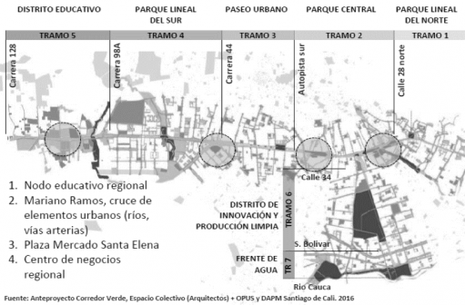
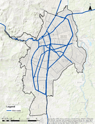
The Caliveable project (www.caliveable.com) is a research initiative led by Dr Daniel Oviedo at the DPU and funded by the Lincoln Institute of Land Policy. The project involves a multi-disciplinary team of UK-based and Colombian researchers seeking to develop frameworks and methods for baseline studies of liveability and the social determinants of health of nascent transport-centred urban projects. The project argues that by building on rigorous and tested frameworks such as liveability, which are cross-cutting to both the built environment and health, it is possible to construct tailored baselines for the design, monitoring and evaluation of the effects of transport-centred interventions on the social determinants of health. The project studies Cali’s Corredor Verde (CV) as the empirical context for the development and implementation of the study. The CV is a large-scale infrastructure and public space investment programme aimed at enhancing social, economic and regional integration with a regional train at the centre of urban interventions traversing the city from north to south.
The Corredor Verde project has a modern public transport system intending to serve as regional link with emerging poles of population and economic growth near Cali (e.g. Yumbo, Palmira). The corridor also intends to become an environmental anchor and axis for supporting urban biodiversity, linking interconnected biodiversity points and support structures – such as waste and recycling plans, nurseries and educational trails. The transport dimension of the project aims to promote active travel and urban transformations based on the notions and principles of TOD, which align with the overall objective of re-unifying the eastern area of Cali with the rest of the city. However, there is no evidence on how this is consistent with the implementation of measures that promote determinants of health and liveability neither on the guidelines or the project’s masterplan. Moreover, given the socio-spatial distribution of the population, the investment rises questions regarding its distributive effects. Will the citizens from both sides of the corridor be benefited equally? Could the CV create an increase in land value and consequently ignite processes of gentrification and expulsion of low-income residents?

Source: Caliveable, 2019; OPUS, DAPM and Espacio Colectivo Architecture team, 2016.

Harnessing the links between transport, liveability and health

We aim to examine liveability in seven domains – employment, food housing, public space, transport, walkability and social infrastructure – linked with health and wellbeing outcomes (6). Two challenges emerge when approaching a project such as the Corredor Verde from a liveability perspective: the first is lack of purpose-built data for comprehensive analysis of the different dimensions of the concept, the second is lack of resources for collecting a sufficient sample that can serve in later stages for impact evaluation. The Caliveable project addresses these challenges using web-based geo-questionnaires designed for participatory mapping. We optimised resources available to deploy targeted field data collection campaigns in areas with lower income and access to technology and neighbourhoods with high levels of illiteracy and other restrictions for self-reporting. Using  Maptionnaire (www.maptionnaire.com) the team has designed a comprehensive 15-minute questionnaire dubbed The Calidoscopio, that allows building indicators based on numerical scales, Likert, multiple choice question, multiple choice grid and draw buttons. Drawbuttons are a feature of the approach of participatory GIS as it enables respondents to map out different features of their behaviour and their urban environment.

The Maptionnaire platform enables the construction of geographical-based features, making it possible to crowdsource mapping for different purposes. For example, a respondent is asked to draw the area of the neighbourhood they perceive as more polluted and then evaluate how they perceive how this contributes/affects their quality of life. The graphical result allows both the interviewee and the researcher to work with a superposition of georeferenced and self-completed information layers. The platform also allows mapping routes and points in the city, which are relevant for transport-specific analysis such as accessibility and walkability. The superposition of layers of analysis through easy visualisation is one of the key advantages of the web-based tool for participatory GIS.

Source: Caliveable, 2019

Initial findings from the deployment of the liveability questionnaire in Maptionnaire have produced comprehensive information about behaviours, preferences, needs and perceptions, not often captured by traditional data collection methods applied in transport studies. The tool enabled the research team, even from the pilot stage, to add a spatial dimension to variables explicitly linked with the social determinants of health, informing location, distribution and characteristics of the built environment from an urban health perspective. This will inform not only planning and development of the Corredor Verde and other relevant transport infrastructure projects in Cali, as well as leaving a replicable methodology for monitoring and evaluation. The Caliveable project seeks to establish alliances with government authorities and researchers for the appropriation of the tool and scaling-up of the methodology for future health monitoring and impact assessments of the Corredor Verde.


Learning from the experience: transport equity and participatory mapping

Experiences with the use of alternative methods for data collection have been introduced in the DPU’s curriculum for years. Such practice has continued in the context of our Transport Equity and Urban Mobility module of the masters in Urban Development Planning course. Students have received training in the Maptionnaire tool and have had the chance of designing and deploying a small-sample test survey in the London Bloomsbury area. Students from across the DPU and the Bartlett have used participatory GIS questionnaires to address issues such as night-time mobilities, liveability and well-being related to transport, transport and security, and walkability. The experience with the use of innovative methods and technological tools for data collection have served for collective reflections about the role of data in leading to more inclusive and sustainable urban transport planning and the need for grounding innovative methods in rigorous conceptual frameworks and context-specific considerations as those covered during the module. The exercise also informed reflections related to research ethics, data management and privacy and the challenges of development research in the digital age.


References

  1. Paget-Seekins, L., & Tironi, M. (2016). The publicness of public transport: The changing nature of public transport in Latin American cities. Transport Policy, 49, 176-183.
  2. Vergel-Tovar, C. E., & Rodriguez, D. A. (2018). The ridership performance of the built environment for BRT systems: Evidence from Latin America. Journal of Transport Geography.
  3. Sarmiento, O. L., del Castillo, A. D., Triana, C. A., Acevedo, M. J., Gonzalez, S. A., & Pratt, M. (2017). Reclaiming the streets for people: Insights from Ciclovías Recreativas in Latin America. Preventive medicine, 103, S34-S40.
  4. Salvo, D., Reis, R. S., Sarmiento, O. L., & Pratt, M. (2014). Overcoming the challenges of conducting physical activity and built environment research in Latin America: IPEN Latin America. Preventive medicine, 69, S86-S92.
  5. Becerra, J. M., Reis, R. S., Frank, L. D., Ramirez-Marrero, F. A., Welle, B., Arriaga Cordero, E., … & Dill, J. (2013). Transport and health: a look at three Latin American cities. Cadernos de Saúde Pública, 29, 654-666.
  6. Badland, H., Whitzman, C., Lowe, M., Davern, M., Aye, L., Butterworth, I., … & Giles-Corti, B. (2014). Urban liveability: emerging lessons from Australia for exploring the potential for indicators to measure the social determinants of health. Social science & medicine, 111, 64-73.


Health in urban development blog series

How and in what ways can local-level risk information about health and disasters influence city government practices and policies?
By Cassidy A Johnson

Treat, contain, repeat: key links between water supply, sanitation and urban health
By Pascale Hofmann

Health in secondary urban centres: Insights from Karonga, Malawi
By Donald Brown

Gaza: Cage Politics, Violence and Health
By Haim Yacobi


If you are interested in DPU’s new MSc in Health in Urban Development, more information can be found on our website.

Mapping Everyday and Episodic Risks

By Rita Lambert, on 1 December 2015

The cLIMA sin Riesgo research project in Lima, Peru, adopts participatory mapping as a means to gather quantitative and qualitative information to capture varying degrees of natural and man-made conditions of vulnerability that affect women and men living in the center and in the periphery of the city. The process is designed to open up dialogue between various stakeholders, with the aim of informing the design of interventions that prevent and reduce risks.

To better understand the everyday risks that inhabitants of the two case study sites are exposed to, we spatialise our inquiry capturing how these risks are distributed and where they accumulate in space (Figure 1). This is a necessary step in identifying how, and where, risk traps need to be disrupted. Preliminary findings suggest that actions taken in one place to mitigate risk may, in effect, externalise the risk to other locations. Hence mapping to make visible the interdependencies that constitute and shape a given territory becomes a vital step in our enquiry, particularly as we seek to devise solutions for an integrated, and co-produced planning.

Figure 1. Drone image of Barrios Altos used to identify residential plots, cultural heritage buildings and other uses such as storage, which is defacing the historic centre. Photo: Rita Lambert

Figure 1. Drone image of Barrios Altos used to identify residential plots, cultural heritage buildings and other uses such as storage, which is defacing the historic centre. Photo: Rita Lambert

This notion of interdependencies materialise at different scales in both Barrios Altos (BA) and José Carlos Mariátegui (JCM). Therefore the analysis is undertaken at various scales. In BA, some of the quintas (multi familiar residential plots) that have private ownership, also present a weakened social organisation.  The quinta, which used to function as an identifiable unit, with common areas and the shared goal amongst residents to improve these areas collectively, now works as a group of individual structures.  The impact of such changes is noted as some households undertake improvement works and in doing so, move away from the traditional one storey structure made of adobe, replacing it with multi-storey brick and concrete buildings. As the structural integrity of the buildings are weakened due to the disparate materials used, the residents are differentially exposed to risk. Besides the increased physical risks that such practices bring, the weakened collective action and organisation also increases the vulnerability of residents to land trafficking activities.

Figure 2. Surveying team in action in BA. Photo Rita Lambert

Figure 2. Surveying team in action in BA. Photo Rita Lambert

Moving out of the quinta and analysing the scale of the manzana (block), it is possible to capture the increasing threats which are claiming the Historic Centre. Land speculation is leading to the slow eviction of  many vulnerable tenants. Moreover, the cancerous growth of storage facilities, also increases the likelihood of fires with the storage of highly flammable materials. If a quinta is adjacent to any of these conditions, it is also more vulnerable, as different land use types interact to increase risk.

In JCM, the interdependencies materialise on the slope. Risk is unevenly distributed with those higher up the slope having to pay more to mitigate risk and make the area habitable. However the occupation in the higher parts, as well as the opening up of roads by large scale land traffickers to capitalise in this area, also increases risk for the lower parts e.g rock falls etc. The latter also have to invest to cope with this risk. Hence mapping at the scale of settlements can make visible where risk mitigation strategies are taken and where risk is externalised to.

Figure 3. Undercutting of slope to create a habitable plot led, in this case, to the partial collapse of the foundation of an existing structure. Photo: Rita Lambert

Figure 3. Undercutting of slope to create a habitable plot led, in this case, to the partial collapse of the foundation of an existing structure. Photo: Rita Lambert

Having analysed how risk is mapped by various institutions in Lima, the project acknowledges the need to work at a finer scale. Many of the official maps homogenise risk painting large areas in red, whilst a more grainier and differentiated understanding of everyday risk is sought in this project. For this purpose, the base maps used also need to be at a level which show subdivisions in built structures. As the Cadastral Institute of Lima only provides the information at manzana or plot level, the SEDAPAL maps are hereby used as a base because  they show water connection in every household and thus capture subdivisions. Furthermore, in the process of data collection, high resolution drone images for each area are used in a process of manual mapping (Figure 1) undertaken in parallel to digital mapping using EpiCollect+, a free application on smartphones which enables the digitalisation of surveys as these are collected.

Figure 4. Inhabitants of JCM indentifying their plots and the limits of their settlements. Photo: Rita Lambert

Figure 4. Inhabitants of JCM indentifying their plots and the limits of their settlements. Photo: Rita Lambert

Departing from the need to map everyday risks at various scales, the project will undertake geo-referenced surveys in both areas at: 1) the household level, to assess the individual investments made to mitigate risk; and 2) at the quinta level in BA and the settlement level in JCM, to assess the collective investments.  The data collection takes a significant representative number: in BA, 30% of quintas in a manzana (40 manzanas in total are chosen, representing half of BA area) and in JCM, 30% of occupied plots for each of the 11 settlements under study. The participatory nature of the process involves capacity building in mapping, the integration of residents in data collection, and the co-design of the survey to include information that inhabitants deem important to them. This means that the method is also used to strengthen existing processes of change, particularly supporting social mobilisation and integrated planning. In BA, community leaders, accompany the fieldwork, sharing information and communicating with others in their neighborhood. This is a necessary step to promote collective action and resist unwanted changes. In JCM, on the other hand, identifying the various investments made over time in each settlement, and making visible the increased investments that need to be made to continue this form of urbanisation raises consciousness of the ripple effect created by atomised actions upon the territory.  This paves the way for an integrated planning between settlements but also more coordinated actions between inhabitants and state agencies.

For more information of the research project cLIMA sin Riesgo please visit the site: http://www.climasinriesgo.net/

You can also access some of the outputs released so far in the following links:

Newsletter No 1, June 2015 “Reframing Urban Risks”

Policy Brief: No 1, June 2015 “Urban Risk: In search of new perspectives”

Video Interview with Principal Investigator of cLima sin Riesgo, Adriana Allen, about the importance of amplifying knowledge of everyday and episodic risks and the objectives of the project


Rita Lambert is a teaching fellow at the Development Planning Unit, UCL, where she is primarily engaged in the planning and delivery of the practice module of the MSc in Environment and Sustainable Development.

Originally from Ethiopia, she undertook her university studies in Edinburgh and London. She graduated from the Architectural Association in London, where she later taught for 4 years in the final years of the Diploma in Architecture.  In 2009, she studied in the MSc in Environment and Sustainable Development, at the Development Planning Unit , UCL.

Her particular interest lies in mapping, as a tool which can be adopted by ordinary citizens to navigate institutional barriers and expand the room for manoeuvre towards environmentally just urbanisation.

Street Messages and Creative Placemaking

By ucfucmt, on 17 November 2015

“Unfold a street map of London, place a glass, rim down, anywhere on the map, and draw round its edge. Pick up the map, go out into the city, and walk the circle, keeping close as you can to the curve. Record the experience as you go, in whatever medium you favour: film, photograph, manuscript, tape. Catch the textual run-off of the streets; the graffiti, the branded litter, the snatches of conversation. Cut for sign. Log the data-stream. Be alert to the happenstance of metaphors, watch for visual rhymes, coincidences, analogies, family resemblances, the changing moods of the street. Complete the circle, and the record ends. Walking makes for content; footage for footage”

Robert MacFarlane, a Road of One’s Own

Picture taken by Claire M. Tunnacliffe in Brixton, London

Picture taken by Claire M. Tunnacliffe in Brixton, London


In July 2015, I received a grant from the Academy of Urbanism to explore street messages and creative placemaking within rapidly changing urban spaces. Broadly, my research has explored the encounter with artistic interventions within the urban environment and how they interact with our everyday lives. Within this project more specifically I wanted to go to the encounter of urban street art in four neighbourhoods of London which were all going through processes of change: Brixton, Peckham, Brockley & Shoreditch. This sought to do three things:


  1. Collect images to refer back to and see if themes would become apparent,
  2. Create a working definition of creative place making in terms of street art, and,
  3. Understand where street art fits into narratives of rapidly changing spaces.


What is urban street art and/or street messages?

I was about half way through the project that I stopped referring to the art I was encountering in the street as urban street art, but as street messages. I was rather confusingly for others, and myself, either interchangeably using the words or just saying street messages.

Street art is, basically, art in the street.

But, the reason why I decide to move away from calling it street art is because it did not encompass everything I began to encounter in the street. I wanted it to include, yes, what we understand as street art, but also graffiti (from the italian graffiare, to scratch), tagging (writing one’s name or symbol), feel good stuff, retorts, hactivism (to distort the original meaning of something, like road signs, to create new meaning), calligraffiti, portrait pieces, community murals, inspirational quotes, etc.

I’m personally, drawn to seeking out what seems to be the more impulsive act of grabbing a pen or a spray can and writing on the walls or surfaces. It comes from an individualistic desire but connects to others because it comes from a personal place, connecting empathically.

I guess the difference I am trying to make here is that there were some encounters with street art or street messages that can be immediately understood. You do not have to go away and do some research to understand what that particular piece is trying to do, and you do not need to be in the street art or graffiti world to understand it. I understand it because the message is clear, and I connect to it as a person.

Providing context to the images changes how we engage with it, and therefore how we respond to it. This came up during various points of the project. Because the project was taking place in the street and at the point of encounter with urban street art, I could not assume that people who pass by it go or would go home to research. I wanted to understand their view of the art as they saw and understood it in the very real here and now.


What about the process?

Walking & Filming

Over the months of July & August I set out on a series of walks with different people. I don’t know how you experience the city, but I’ve walked a lot across it. Walking is something that I think in a place like London that is so busy and stressful and where we all lead these very full lives, slowing down is not something that comes quite as naturally anymore. So part of what I wanted to do to understand different areas was to go out there and get a bit – well – lost. And it was in that process of unknowing, the destination, the people we would meet, the conversations that we would have, without having an agenda, which proved to be very exciting. By slowing down, we were able to tap into the pulse of the place, and at the same time open ourselves up to encounter.

During the course of the project I was lucky to meet Jayni Gudka, a filmmaker who wanted to do a short film around the experience of the project. Creating a film was never something I thought of doing, but is a really lovely way to showcase what and how the project was undertaken.


Neighbourhoods & Talking to People.

London is a constantly changing city, but Brixton, Peckham, Brockley & Shoreditch were interesting in the way street art was framed in each context – part of it’s identity, sometimes to raise awareness, part of regeneration projects, and sometimes to argue the appropriation and use of space. When I was doing my background research on the areas, all had the word gentrification as part of their descriptions, and I wanted to explore how street art and messages fit within those processes.

It was during these walks that I had young urbanists, urban planners, academics, artists, photographers, a filmmaker, strangers, coerced friends, an accountant, an art psychotherapist, a wide range of people that responded to the call out for walkers. I was never lonely on my walks. This response I think is indicative of how many people connected to the project aims.

Photography & Mapping.

I wanted to incorporate an element of mapping into the process. While walking in an area, I would take pictures and locate these images onto a map. By creating a virtual map that could be referred to, I wanted to see what themes would immediately jump out.

There were several problematics with this though. Firstly, I realised that I was taking pictures very much from my lived experience, what was making ME stop and making ME think and making ME want to take a picture – it could have been a different interpretation by someone else. Lesson learnt, I need to involve more people at this stage. Secondly, these pictures are not exhaustive and I have simply taken into account a tiny percentage of what’s out there.

Workshop

As the walks came to a close and I now wanted to understand the outcomes of it, I organised a workshop to answer some of the aims I had initially set out with. It was also really important involve others in this process, as I wanted to dilute my interpretation of things from my own experience – and a wide range of people were invited to take part. As a group we set about figuring out themes. This involved using the same map you can see over there, and placing images that were taken on the walks around it. By first separating them into neighbourhoods, and then into categories, themes began to emerge.


What happened?

Over the course of the walks, and during a workshop that took place back in September, themes started to become apparent. Such as:

  1.     Against the system/Critiques of Technology.
  2.     Instructions & Street Philosophy.
  3.     Aesthetic – images that possibly needed more of a context and background to them to undertand.
  4.     Animals/Nature.
  5.     Gentrification.
  6.     Love.

But what do these themes mean in the context of these neighbourhoods?


BRIXTON

Picture taken by Claire M. Tunnacliffe in Brixton, London

Picture taken by Claire M. Tunnacliffe in Brixton, London


Brixton is a bustling area, a transportation and market hub. It’s very diverse. It’s also rapidly changing. Earlier this year, network rail began evicting some 30 local independent businesses from within the arches running along Atlantic Road and Station Road, some of which have been in the area for around 40 years. Together with the market, they constitute what is largely considered the heart of Brixton.

The Save the Arches petition began as a response to that, and part of it was also a movement started by local street artist PINS. Initially contacted by a local business to paint their shutters in response to the eviction, PINS then contacted some of his artist friends, spoke to other businesses, and organised more shutters to be painted, helping to raise awareness of the situation. This image is now iconic of the struggle happening in Brixton.

Walking around Brixton was a lot of fun and we met and spoke to many people. The importance of community – through the Save Brixton Arches Campaign shutters, but also to the responses around them – the writings I miss my Brixton, F*%& your new flats, and others – were indicative of feelings around the changes taking place in the area.

We met Phil, Amara & Aleksi from Small World Urbanism, an organisation that uses gardening and art with a community focus. On the day we were walking they were painting bees and planting on beehive place – this small oasis of plants and animals in an urban environment felt like a haven, particularly against the new Brixton Pop structure. Lining the walls were also portraits by James Pearson, an Australian artist who had done the portraits of characters of this particular stretch. We met a few of them, particularly John who spent a long time telling us about growing up in Brixton, the businesses lining the road. There was a great energy about the place, people stopping and chatting and adding their own thoughts to the changes in Brixton.

PECKHAM

Picture taken by Claire M. Tunnacliffe in Peckham, London

Picture taken by Claire M. Tunnacliffe in Peckham, London

I don’t really know Peckham. Before the walks, I’d been there once or twice over the last couple of years. Coming out of the station, you’re fed out of small tunnels and into a bustling high street of stalls piled high with yam and cassava, fishmongers and butchers, and music blasting in the street. Peckham is one of the most diverse communities in London, which also plays home to many of its best art schools. It is an area that’s undergone changes in the last few years, with the influx of cafes, wine bars, niche shops and artists studios. One of my favourite pieces that we came across during those walks was a David de Brito (São Paolo) painting that originally read “I love Peckham” and where someone had come by and written over it – I hate the new Peckham.

Just off Rye Lane, walking past vegetable stalls, you come into a parking area with lots of cars, a restaurant, and a lot of graffiti, tags and street art. We also spoke to a man in his fifty’s sitting on a chair. I asked him about the street art and graffiti. He says he started it all. One day a girl came and did it, took a couple of pictures, but the next day he got there and someone had written all over it. He rang her up and she said that was just the way of the street – open to response, to be defaced, to be altered to be hated or loved. I think this touches on how street art, graffiti occupies such a different space in our visual culture. With advertising we aren’t allowed to respond, if we do it is vandalism, but with street art and messages you can. It becomes a really fluid space for dialogue, even if it’s just to swear.


BROCKLEY

Picture taken by Claire M. Tunnacliffe in Brockley, London

Picture taken by Claire M. Tunnacliffe in Brockley, London


Brockley was an interesting walk as it was so different from Brixton & Peckham. It didn’t have the same activity, hustle and bustle, there were less people milling around, it had a much more suburban feel to it. As an area it deserved more walks at various times during the week. It didn’t quite work as a space to just go and see what happens.

Here, the walks actually followed the Brockley Street Art Festival that took place earlier in the summer. These paintings are legal, having sought the OK of the local council to paint on walls and hoardings. The catalyst for the festival was actually because just outside Brockley Station a Bob Marley Mural was removed to build new flats. The community was upset as it had been around for forty years. So, it set out to recreate it and then some.

The festival itself aimed to improve the appearance of the Brockley Corridor and its surrounding neighbourhood through a showcase of murals by local, national, and international artists. I was personally really interested in some writing on hoardings, actually on the outside of this new building going up which has three white women shopping for cacti (who knew it was a thing?) and someone has taken a pen and responded with “the mortgages are like so affordable” but also “Brockley is on the down turn, like the rest of UK”.

I did speak to a few people, and everyone found them quite beautiful. But it remained at that. So, Brockley primarily seemed more aesthetic in its use of street art, but also had some retort in the form of these scribblings on hoardings. I left feeling like Brockley was at the beginning of certain change.

SHOREDITCH

Picture taken by Claire M. Tunnacliffe in Shoreditch, London

Picture taken by Claire M. Tunnacliffe in Shoreditch, London

Shoreditch needs no introduction. Because it’s such a vibrant space for street art, I initially didn’t want to go there as I thought that whatever ‘messages’ I was hoping for wouldn’t be there – too consumeristic, I thought. Intrinsically, this is the space that revealed the most pieces against the system. During the final walk in Shoreditch, the term “post-gentrification” was used, and it came up again in the workshop. Though there are several problematics with using phrases like this, I believe it helped to understand that a change has occurred so fundamentally that it now did not look like anything it once was.

As the last area to go walking in, it was easier to look back on the four neighbourhoods as different moments in a process of change. The themes revealed a narrative around changing spaces, and in Brockley-Brixton-Peckham & Shoreditch street art becomes embroiled in processes of change.

The other neighbourhoods seemed to fit into different stages of change with Brixton, Peckham, Brockley and Shoreditch all sitting on some spectrum of change, and with urban street art framing some of the narratives of that change. I think something to tease out of this project is to focus more on what those phases would be.

What is Creative Placemaking?

I became aware that I hadn’t really given a definition of what this means. That’s predominantly because throughout the project, I’ve been trying to define it. I obviously had some notions of what it did mean to me, but again in the same way with just going for a walk, I wanted to see what would happen if I didn’t try to shove my preconceived idea of what it had to mean without interacting with it in the first place.

It was during the workshop that we began deconstruct and then reconstruct each word. What this meant was that when we recombined them they revealed new understandings. So for example, creative place making also became: innovative environment building, or; chance transcient curating, or; ephemeral attachment consciousness.

In a nutshell, this is what Creative Placemaking has come to mean to me: the act of creating something that connects you to a physical space for a moment. In that moment, that space is yours and forms your identity.

Is there a single definition? Absolutely not. I believe that Creative Placemaking can be very different things depending on intent of the maker – Indeed, I would argue that creative place making can only be experienced by the maker. Is it a working definition? Yes. Creative place making, is also not a process with an end point, but the constant transforming, defining and re-defining, and curating of public spaces. Street art and street messages exist in an interesting space. By straddling legal and illegal divides, by being driven by different needs – community, individualistic, ego, aesthetic – it is a very active process.

Finally, I believe that street art creates narratives, allowing us to understand changing spaces. In order to understand a community, we should look at its walls.


Claire is a DPU MSc Environment & Sustainable Development Alumni. Since graduating in 2012, she continues to research the role of urban street art in re-naturing urban imaginations and experiences. She is a PhD student at the Bartlett School of Architecture exploring street messages in West African urbanism. However, her interests are interdisciplinary; community engagement, urban street art, public interest design, sustainable development, town planning, creative cities, art psychotherapy, mental health, the psychodynamics of public spaces, and their impact on place making in the city. Her project Street Messages & Creative Place Making was funded by the Academy of Urbanism Young Urbanist Small Grants Scheme.


Exploring possibilities for community-led urban land development in Dar es Salaam

By ucfurli, on 19 May 2015

For the past two-weeks students of the MSc Urban Development Planning have been working in three sites across Dar es Salaam, Tanzania, as part of their field trip project supporting community-based initiatives for informal settlement upgrading.

Working with the Center for Community Initiatives (CCI), a local NGO, and members of the Tanzanian Federation of the Urban Poor, students have been trying to understand the realities of urban life in these three areas while developing ideas to guide more socio-environmentally just trajectories of urban development at the city-wide scale.

Incomplete houses on the Chamazi site Image: Rafaella Lima

Incomplete houses on the Chamazi site
Image: Rafaella Lima

The three sites in which the groups are based—Karakata, Chamazi, and Mabwepande—have much in common: they are all growing peri-urban areas, they are all mostly “informal” or “unplanned”, most residents are low-income, and they face similar interlinking challenges such as infrastructure, access to basic services, sanitation, and solid waste disposal. But they also represent different patterns of land acquisition and development within the Tanzanian context.

Learning about the Gulper machine, a mechanism that the Federation has been using for the emptying of pit latrines in Karakata.

Learning about the Gulper machine, a mechanism that the Federation has been using for the emptying of pit latrines in Karakata.

Karakata is the longest-established settlement of the three, and developed as residents from elsewhere in the city moved further out in search of more affordable land and rent prices. Considering Karakata’s close proximity to Julius Nyerere International Airport, as well as its diverse array of livelihood activities, the value of the land is currently rising at a rapid rate.

Residents face big issues such as sanitation and access to medical services, and the rapid erosion of the river in the area presents a grave environmental threat. Students assigned to this site have been working on ideas such as community-led environmental risk assessments and a more sustainable model for the Federation’s waste-disposal system.

Mapping the route between Chamazi housing site and the town centre.

Mapping the route between Chamazi housing site and the town centre.

In Chamazi, Federation members formed a housing cooperative to collectively purchase a plot of land to build homes for those who were evicted by the government from Kurasini Ward in 2008, due to the expansion of the port area.

However, since the project began in 2009, many houses have not been completed and a high percentage of families have yet to move to the site. One hypothesis for this has been that Chamazi’s distance from the city center (sometimes 3-4 hours with traffic) means much fewer livelihood and employment opportunities.

But the Chamazi site is not as isolated as it once was; in only the past few years the area around Chamazi town has grown rapidly, bringing new businesses, markets and services. UDP students have been exploring the seeming disconnect between the housing site and the town, along with the financing of the housing project to understand how it can remain affordable and viable.

A student-led focus group trying to understand the dominant challenges in Mabwepande.

A student-led focus group trying to understand the dominant challenges in Mabwepande.

Mabwepande is another peri-urban site for relocated people, however in this case the government allocated land for victims of flooding in the more central Suna zone.

At the moment the area feels rural and many residents use the non built-up space for agricultural purposes, but we have yet to see how increased development of the area and new pressures on land will affect them.

As the Federation has only just begun working in this site, Mabwepande had yet to be mapped in a way that was accessible to its residents. Along with conducting interviews and focus groups to begin to build a larger picture of the Mabwepande community, students created maps with the help of community members to be shared on the site.

Students present some of their findings and ideas to community members in Karakata.

Students present some of their findings and ideas to community members in Karakata.

These three sites are illuminating important citywide processes, such as the uncertain institutional relationships that govern the urban poor’s access to land (for example, there is no clear resettlement policy that might guide the relocation of people like in Chamazi and Mabwepande).

Students are understanding the notion of “scale” in practice, as they come to grips with the scale of informality and poverty across Dar es Salaam. This has been underpinned by the rainy season, in which intense flooding across the city has brought the hardships faced by Dar’s poorer residents into clear focus.

Observing a Federation and CCI-led focus group used in settlement profiling in Vingunguti settlement.

Observing a Federation and CCI-led focus group used in settlement profiling in Vingunguti settlement.

Finally, there is the challenge of gathering reliable data in a city that is growing so rapidly, in a context where certain forms of knowledge are not recognized. The field trip focuses on the way knowledge is built at the local level as students learn from the Federation model of settlement profiling, enumeration, and mapping.

In return, students offer input and experiences from their diverse home countries to try and support community-led processes of co-production of housing, land development, and knowledge.

The Philippine Alliance: collaboration for planning and design

By ucfujmm, on 17 March 2015

In January this year, three DPU alumni travelled to the Philippines to work with the Philippine Alliance as part of the DPU-CAN-ACHR Junior Professional programme for six months. This blog kicks off a four-part series from the interns, serving as an introduction to the work of the Alliance.

The next posts will explore and reflect on different aspects of its work; community mapping (as told by Mariangela Veronesi, based in Metro Manila), community mobilisation (thoughts from Laura Hirst, in Davao) and settlement planning and design (from Jessica Mamo, in Mandaue). This first post gives a brief overview of the history, structure and different partners in the Alliance, along with how they work with the urban poor in the Philippines.

Community mapping in Barangay Ilang, Davao City, March 2015. © Laura Hirst

Community mapping in Barangay Ilang, Davao City, March 2015. © Laura Hirst

The Philippine Alliance: a brief background

The Philippine Alliance works with the urban poor living in informal settlements across the Philippines. They also work with other vulnerable groups, such as communities living on land susceptible to natural and man-made disasters or those facing the threat of eviction. Through partnerships with local government and other stakeholders they provide sustainable housing solutions for the urban poor.

The Alliance itself is a partnership between five organisations; Homeless Peoples Federation Philippines Inc. (HPFPI), Philippine Action for Community-led Shelter Initiatives Inc. (PACSII), Technical Assistance Movement for People and the Environment Inc. (TAMPEI), Community Resources for the Advancement of Capable Societies (CoRe-ACS), and LinkBuild. Each of these organisations has a particular role, and work together throughout the process of acquiring land tenure and providing new housing solutions for the urban poor.

Homeless Peoples Federation Philippines Inc

The work of HPFPI started in the 1990s with the creation of savings groups among waste-pickers living on a garbage dump site in the barangay (neighbourhood) of Payatas, in Quezon City, Metro Manila. Originally addressing immediate needs, the programme evolved to tackle issues of land security and eviction. Its successes in Quezon City, in addition to local and international networking and exchanges, encouraged the federation to intensify its work and expand across the country.

Today HPFPI is a national federation of community associations and savers pursuing community-led housing and upgrading processes.

The main role of the federation is to promote and facilitate savings among member-communities, as a way of building their financial capability to invest in their own development. This mobilisation aims to uphold the aspirations of its members to secure their own land, maintain decent living conditions, break the cycle of poverty, and protect their dignity and human rights.

Diagram 1: The Philippines Alliance; Partners and their main responsibilities

Diagram 1: The Philippines Alliance; Partners and their main responsibilities

Philippine Action for Community-led Shelter Initiatives Inc

PACSII is a non-profit NGO, registered in 2002, and serves as the intermediary support institution to HPFPI, coordinating the Alliance’s programmes across the various regions, providing overall guidance in their mission.

PACSII provides extensive assistance on legal and financial matters, finding resources, serving as a legal holder for these resources, but most importantly giving the federation the space and opportunity to genuinely develop as a community-driven institution.

Technical Assistance Movement for People and the Environment Inc

TAMPEI is the technical support unit of the Alliance, supporting the federation in community-led technical processes, specifically through the design of low-cost incremental housing, community upgrading, community mapping and planning initiatives at different scales; from community to city level developments.

Community Resources for the Advancement of Capable Societies and LinkBuild

LinkBuild and CoRe-ACS are newly-formed social enterprise and micro-finance institutions which support the communities that form the federation. LinkBuild provides development finance and builds houses while Core-ACS provides end user financing for low-income families through accessible loan systems.

LinkBuild was formed in order for the Alliance to deliver sustainable housing to scale for HPFPI members, affiliates and partner community networks. HPFPI and TAMPEI are directly engaged in the project planning and implementation processes in order to ensure community preparedness and involvement.

Surplus and cross-subsidy projects are being explored as means to sustain the programs and make housing affordable for very low-income families. Houses constructed by Linkbuild are sold to CoRe-ACS, which is then responsible for handing over the houses to households who have been assessed and approved to receive a housing loan, and administrating and collecting these loans.

Diagram 2: The methodology adopted by the Philippine Alliance, and associated partners involved in each stage

Diagram 2: The methodology adopted by the Philippine Alliance, and associated partners involved in each stage

How the Alliance mobilises member-communities

Although the process varies depending on the context, the starting point for the federation has historically been the mobilisation of communities through the promotion of savings. As communities become mobilised, the aspiration of securing their own land becomes progressively more realistic. Another important stage is the collection of relevant data regarding the community, referred to as community mapping.

If the community has already been organised by HPFPI, the mapping process can represent a crucial step before moving onto planning and design. Nonetheless, mapping can also be used in communities that are not yet organised or involved with HPFPI.

In fact it is often used as a strategy to start interacting with a community and to then introduce the concept of organising and saving to find housing solutions. For large projects, such as housing development, mapping is an important stage which profiles the settlement.

Taking a participatory approach, data is gathered at the household level (for example the number of families, occupations, building structure and facilities), on physical characteristics (such as the boundaries of the settlement and the communities present) as well as on the historical development of settlements.

Once the data has been gathered, verified, analysed and synthesised by community members, it is presented to the wider community, to be used as a tool in the next stage of community land acquisition, planning and design.

What are DPU interns doing?

Throughout our time here we hope to be working in different capacities on all stages of the process in order to support the Alliance in its work and to learn from their experience.

Look out for the three forthcoming posts about our work and experiences in the coming weeks.


Jessica is an architect and has recently completed the MSc in Building and Urban Design in Development at the DPU. Currently, she is working in the Philippines, as part of the DPU-ACHR joint internship programme. Her interests lie primarily in community-led upgrading, particularly with regards to housing and service provision. 

BUDDcamp 2015: Urban Space 2 – Caffaro

By ucfugca, on 25 February 2015

2_caffaro (18)-1_left

URBAN SPACE 2: Via Villa Glori and ex Caffaro Adjacent Area

Caffaro in Brescia is synonymous with pollution. The Caffaro plant has been active since the beginning of the 20th century, producing chemical elements including PCB, which has contaminated vast tracts of land causing serious health problems such as a dramatic increase in cancer rates among the residents.

At the end of 2015, the plant will be definitively closed and with its closure the current occupants will stop performing certain procedures that prevent the pollution to reach the groundwater. Certainly, the closure of the plant and the future of the contaminated area will become yet again a highly debated topic in the local media. The group was asked to explore the possibility of redeveloping the site from a social point of view.

The students felt the need to explore how visible the issue of Caffaro is by investigating how much is known about the plant in its neighbourhood, where almost only migrants have settled.

2_caffaro (19)-1

Spatial Fragmentation

The group writes: “We engaged with the spatial experience of the site, noticing closed green parks, high-walled factory boundaries, unclear pollution warning signs as well as several community activity centres. We got a strong impression of fragmentation and a lack of a singular or coherent identity, spatially or socially. The large presence of migrants from multiple backgrounds, led us to wonder about their perception of Caffaro.

We believe engagement with local communities is essential to create common ground between actors involved. The key point of the interventions is to co-create knowledge of the factory to increase the sense of community by engaging local people in the development agenda.

2_caffaro (10)-1

Mapping Cultures and Languages

Sri addswe mapped the languages spoken by those who live or work around the factory and we proposed to engage the migrants in co-producting knowledge about Caffaro.”

Rui: “we proposed a map that shows where native speakers willing to share information about the pollution are located.”

Group: “The map is made for visitors, existing residents and also new migrants. In cooperation with LDA, newly arrived refugees can find ambassadors of their language/culture to visit and hear stories about Caffaro. Not only does this allow them to be informed about the pollution from the beginning of their stay, but it also has the benefit of increasing their social network as it connects them with long-term residents that share their language.”

2_caffaro (18)-1_right

Having recognised that the existing multiple narratives – amongst which alarmism and denial, indifference and resilience – should be equally represented, a second proposal envisions the creation of ‘community wall paintings’; an activity in which existing residents are asked to decorate the brick walls that enclose Caffaro’s premises.

“Not only will this make the factory (and its story) visible to everyone who visits the area, but it will also bring different local groups and people together in collective activities”.


Giulia Carabelli is the Graduate Teaching Assistant for the MSc BUDD programme. She joined the current MSc students on the BUDDcamp in February. Look out for reflections from the other 2 case studies on the blog tomorrow and Friday.

The BUDDCamp is a 3-day design workshop, part of the MSc Building and Urban Design for Development’s Urban Intervention Studio where students bring together theory and practice by working on the proposal of innovative design strategies for specific urban issues. For the fifth time, the BUDDCamp took place in Brescia (Italy) in collaboration with the Local Democracy Agency (LDA) Zavidovici, an organization working with refugees and asylum seekers in the city.

Engaging youth in representations of place: more than just an open day

By Liza Griffin, on 5 February 2015

This post and the project exploring place in Kilburn has been undertaken in collaboration with Kamna Patel.

Students introduce their representations of their neighbourhood

Students introduce their representations of their neighbourhood

In the old days school level students saw universities as the most mysterious of places – where and what were they, what do they teach and how? They were rarely told anything much in answer – except that it was a very good idea to try and get in. But how did people know where to apply, and what subjects to choose? Little guidance was available.

Today, much has changed. It’s common for prospective university undergraduates, to attend ‘open days’ available throughout the year from all and sundry higher education establishments. At them, potential applicants can hear from academic staff what to expect if they go university, and learn briefly what different subjects have to offer.

All very useful, but now, academics from Development Planing Unit in University College London are going one step further. We are offering some school students the chance to become undergrads for a time and join us in a research project exploring urban citizenship and place-making.

This is what students at St Augustine’s School in Kilburn have recently done. We have collaborated with Helen Allsopp, their teacher, to run a series of workshops on a favourite theme amongst geographers and planners; a ‘sense of place’

First, the workshops explored the students’ own perception of Kilburn, where they live – what is it like for them, and how much have they noticed recent changes in the area. And they explored how the changes going on reflect the broader processes of globalisation that we are constantly hearing about (e.g. big new developments funded by foreign capital, soaring house prices fuelled by demand from people wanting to work in London, changing ethnic mixes, and so forth).

Explanations of the different methodologies used were displayed around the exhibition

Explanations of the different methodologies used were displayed around the exhibition

Then the students used techniques from the social sciences to analyse different portrayals, or ‘representations’ of Kilburn, coming from diverse sources such as websites, films, written texts in books, magazines, music, social media and so on.

Besides these workshops, the students conducted fieldwork in the area. There, intriguingly, they made maps of how people, including themselves, feel about different parts of Kilburn – identifying, for example, ‘spaces of fear’ where it might be dangerous to go at particular times of day or places where they feel more at home. In such exercises they applied different research methods (such as transects walks through their neighbourhood) as used by social scientists and Town Planners amongst others.

In all this, the students were getting much more than just an ‘open day’ afternoon. Theirs was an in-depth experience, sustained over time, of the kinds of things they might expect to be doing at university, including an up to date view of the sorts of research methods and analysis that planners and geographers might apply in their work. And here, the St Augustine’s students were actually sharing in such work.

IMG_3784

The workshops and fieldwork ran over several months, culminating in the students producing their own representations of Kilburn shown at a roving expedition running throughout 2015 – at UCL, at St Augustine’s and at the Tricycle Theatre in Kilburn. The exhibition’s centrepiece is a series of 3D maps of Kilburn produced by the students themselves. These are not a ‘conventional’, accurate-to-scale representations. Instead they incorporate their different perceptions of, and concerns and aspirations for this busy, dynamic and multi-faceted place.

The exhibition opened in January 2015, and at that opening visitors were guided through by some of the students themselves, explaining the maps and models, and recounting how they were produced. They also had to explain to the audience the practical usefulness of such cultural geography work, in developing peoples’ sensitivity to place and encouraging them to think about how they can help to shape places for themselves and help to give them meaning.

The latter was one of our main aims of the project. In our on going action research on this project we plan to reflect upon the extent to which the participating students, through their involvement, were provided with a sense of how they themselves might be able to shape their own urban environment and ask whether this contributed to a nascent sense of citizenship.

IMG_3805

The project is impressive – partly because of the impression which the students make on the visitors as they are guided round. Here is a group of enthusiastic, smart and articulate young people, with a dynamism that will undoubtedly make them an asset to whatever university they eventually choose if they seek to continue their studies. And hopefully they will have a flying start through their experience of doing some university level work with the academics who will teach them.


Liza Griffin is a Lecturer and Co-Director of the MSc Environment and Sustainable Development at the DPU. Kamna Patel is a Lecturer and Co-Director of the MSc Development Administration and Planning. Both have lived in the Kilburn area.

An honest account of participatory research

By Rosalina Babourkova-Horner, on 2 October 2012

Are you like me, forever enthralled by anything with the adjective “participatory” in front of it? If yes then read on. This is the story of how I felt undertaking my first so-called participatory mapping research project. It so happened that a few months ago I managed to receive small funding for a project entitled “Mapping perceptions of environmental risk and well-being in a Roma community”. The study I had conceived was not designed to effect any particular social action or change, which is, I am sure you know, the crux of participatory action research. Far more self-centered, my reasons were to forge contacts with local NGOs in the Roma community where I wanted to conduct fieldwork for my PhD.

Despite being exposed to countless theoretical discussions and practical exercises on participatory research methods, I never had any real hands-on experience of actually conducting participatory research. The study that I had so successfully sold to colleagues who kindly advised me, to the local NGO which enthusiastically agreed to be my partner in this undertaking, and, of course, to the funders, became just a testing ground for my participatory research skills.

To what extent do we as students (PhD, Masters, Undergraduate) have the capacity to run participatory action research, when at the end of the day the results of our study are often there to suit our own purposes? Is it worth experimenting with those methods when the research question has not been developed in collaboration with a community, which wants to effect a particular change? In absence of an organized community that one as a researcher can work with and support using participatory techniques, are we not just imposing “participation” on people who are taxed in so many ways?

Let me give an example. Already the fact that I was discussing a participant recruitment strategy with my partner NGO shows that real voluntary participation from within the community was not the point. My partners had their usual beneficiaries in mind as potential participants. Not knowing any better, I quickly agreed that having a group of young mothers (who anyways came to the social center every day to drop off their children, and a group of young men the NGO was working with on other social projects), would be the easiest and most effective way to get people involved.

On the morning of the first workshop I was overcome by  the anxiety of not knowing who may turn up and also of standing in the midst of a completely alien group of people whose trust I should have theoretically already developed, but whom I had not personally invited to the project.

About five women arrived to participate in something, what exactly in they had no clue. “We asked for 10-15 to come”, said the centre manager apologetically and proceeded to ask one of his female colleagues to step in to raise the participant number. As coercion crept in my project, I resolved myself to remain relaxed and upbeat. I ended up delivering a rushed introductory session to the goals of my project and a warm-up game of matching photos of famous landmarks to their location on a large-scale city map. Disposable cameras were distributed, along with hasty instructions on how to use the cameras and what to photograph. Although the women seemed like they were listening intently and did well in the mapping game, I felt in a way as if I was wasting their time.

The afternoon session  [with a group of young men] was similarly rushed after they all came late. They were a bit dazed from walking around in the 3pm blistering sun, but obviously summoned by their informal leader, were ready like soldiers to obey the commands of the “foreign general”. I was disappointed with my performance of Day 1 and bitter that I was making people I did not know participate in something when they may have other things to do.

Interestingly, the next day all 12 cameras were neatly stacked on the proud centre manager’s desk.I rushed around to find a photo studio that would develop them overnight, only realising that I had not factored in the cost of express service development into my project budget. The next morning, on the way to pick up the photos, I felt like I could not and did not want to do this any more. But as soon as I saw the photos I was suddenly elated again. The participants had really understood what I asked them to capture. I could not wait to show them their pictures.

Four out of six boys came for their second session that afternoon. They were eager to see what they had shot. This time I felt more at ease guiding them through a discussion of the kinds of environmental problems they had photographed. They actively participated in grouping the photos in themes and ranking the significance of risk, and I began to realise that we cannot talk about problems without talking about potential solutions as well. With each problem addressed, they asked “how can we improve this?” and “who is responsible?”. They decided to send the Mayor some of the photographs. We arranged to meet the following week to prepare picture postcards of the settlement and a petition list also to be sent to the Mayor.

The boys were not interested in the body health mapping exercise through which I had planned to elicit how the environmental risks portrayed in the PhotoVoice exercise would impact on participants’ and their relatives’ health. I left it for the group of mothers without having the time to prepare for it. I quickly improvised and drew some funny-looking outlines of human bodies on the back of used paper I had salvaged from the rubbish bin. Although the women joked that this is really not what they look like, the body maps produced a very lively discussion on health issues that affected the women and their relatives. Gradually the discussion turned into the informal impromptu gossip session that I thought I was preventing previously. One of the women exclaimed: “We could sit and talk like that all day!” and the others agreed that they’ll come again next week to finish off our project.

The night before my final session, the one where I had promised participants that we’ll alert the municipality about the problems they identified through an existing (but currently defunct!) online mapping platform, I had to think of another plan. Necessity being the mother of all inventions, I found myself creating Google accounts for all participants so they could collaborate in creating a Google map of the risks in the settlement. With only three of the mothers and two of the boys turning up for the final session and technology not working quite like I expected, we all clustered around one computer and transferred results from the paper map into the Google map.

Thinking back now about the whole process, it was a mixed experience. Although I grew more confident as a facilitator in the process, I must confess that managing a group process is not my forte. I would do it again, but definitely not on my own. Throughout the process I missed working in a team of researchers. I missed the ability to bounce ideas off each other, discuss pros and cons, having someone to advice and motivate me when things don’t quite go to plan. Ironically, in a process that is supposed to be participatory, I felt at times very lonely. Not to make this sound entirely like “doom and gloom.” I cherished that my participants started opening up to me after the second session. Although I did not get the results I expected, trialing the methodologies proved fruitful for my partner NGO who is now interested in using them further. The project led to some social action in the form of a petitions list and letter (complete with photos and digital map of problems) send to the mayor asking for some very urgent infrastructural improvements.

all photos by the author
Disclaimer: The views, opinions and positions expressed within this post are those of the author alone and do not represent those of the Development Planning Unit -UCL .  The copyright of this content belongs to the author and any liability with regards to infringement of intellectual property rights remains with them.