X Close

The Survey of London

Home

Recording the history of London's built environment since 1894

Menu

Archive for January, 2016

Winstanley Estate, Battersea

By the Survey of London, on 29 January 2016

Social housing has been much in the news lately with the Government’s controversial plans to ‘blitz’ what are considered ‘sink’ estates.

‘David Cameron promises to bulldoze Britain’s sink estates’, The Daily Mail, 10 January 2016

‘David Cameron will not be able to redevelop “sink estates” without a fight’, The Guardian, 27 January 2016

One of those said to be earmarked for redevelopment is the Winstanley Estate, north of Clapham Junction, considered a model of its kind when it went up, mostly in the early to mid-1960s. In fact the area involved includes the slightly later York Road Estate which is likely to be entirely rebuilt, following consultation between Wandsworth Council and local residents.

© Historic England, Chris Redgrave

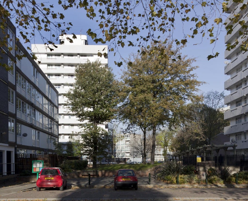
Winstanley Estate, looking north-west from Thomas Baines Road towards Clark Lawrence Court in 2012 (© English Heritage, Chris Redgrave). If you are having trouble viewing images, please click here.

Survey Of London, Battersea, Winstanley Estate, Thomas Baines Road, Battersea, London. General view of housing estate. © Historic England, Chris Redgrave

Winstanley Estate, Thomas Baines Road, photographed in 2012 (© English Heritage, James O. Davies).

The history of the area, its Victorian prehistory of small terraced houses as well as the colourful evolution of the Winstanley and York Road estates from the 1950s to the 1970s were covered in detail in the Survey of London’s volume 50 on Battersea housing (2013). Its assessment generally draws out the relative merits of the Winstanley, with its ‘coherence of design lacking in any other post-war housing built in Battersea’, which is likely to be refurbished, and the ‘uninspired’ York Road with its ‘bulky monotony’, which is to be demolished:

Chapter 8: North of Clapham Junction, draft chapter of Survey of London Volume 50

Survey Of London, Battersea volume. Winstanley Estate, Thomas Baines Road, Battersea, London. General view of Clarke Lawrence Court. © Historic England, JD

Clark Lawrence Court in the Winstanley Estate, photographed in 2012 (© English Heritage, James O. Davies).

York Gardens Pennethorne House London SW11

York Gardens and Pennethorne House, York Road Estate Stage 1, photographed in 2011. Pennethorne House is one of the blocks that is likely to be demolished (© English Heritage, Nigel Corrie).

Though now perhaps best known outside Battersea as the home of garage and hip hop band So Solid Crew, the Winstanley has also provided a filming location for a number of feature films, notably Poor Cow (1967), Ken Loach’s first full-length film as a director, and the Oliver Reed thriller Sitting Target (1972). The Survey was involved with the architecture departments at Cambridge and Liverpool in 2012-13 in a research project called Cinematic Geographies of Battersea. Taking its cue from Jonathan Raban’s 1974 book Soft City, the project explored the different ways that urban histories, such as the Survey, and filmmakers, present the city, whether as the ‘hard city’ found in statistics and maps, or the ‘soft city’ found in the suggestive discontinuities of film. One outcome was a short film about the Winstanley that mixes a voiceover taken from edited Survey of London text about the Winstanley, with archive photos and film clips of the Winstanley, both from newsreel and feature films, to suggest that these hard and soft cities are on a continuum, and not that one is ‘more real’ as Raban suggested, than the other.

The Winstanley Plays Itself by Aileen Reid on Vimeo.

Survey Of London, Battersea, Winstanley Estate, Thomas Baines Road, Battersea, London. Detail of mosaic.

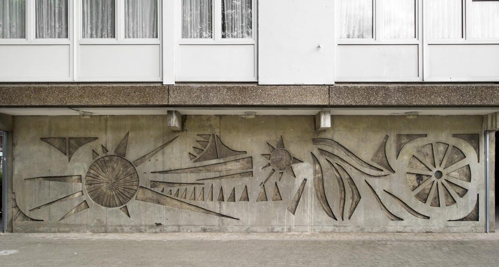
Thomas Baines Road, Winstanley Estate, concrete mural of 1963-5 by William Mitchell & Associates, photographed in 2011 (© English Heritage, James O. Davies).

Whitechapel

By the Survey of London, on 22 January 2016

This blog post is not a history of a site, nor is it like its predecessors about Marylebone or Oxford Street. It is about the Survey of London’s other major current study area, the parish of Whitechapel. This project is still in its early days, so it is too soon for us to be able to offer researched and considered new insights into the area’s architectural history. However, a blog post is an opportunity to keep readers informed of progress, to add to what is on the project’s page on our website.

(© Historic England, Lucy Millson-Watkins)

Altab Ali Park in 2015 (© Historic England, Lucy Millson-Watkins). If you are having trouble viewing images, please click here.

As is explained there, a major new departure for the Survey is being enabled by a significant Arts and Humanities Research Council grant. Starting this month, Dr Duncan Hay, based in the Bartlett’s Centre for Advanced Spatial Analysis with Dr Martin Zaltz Austwick, is working on building an interactive map-based website that when launched in late 2016 will permit public co-production of histories of Whitechapel’s buildings and sites for synthesis by the Survey of London. We are also benefiting from the participation of two research fellows, Shahed Saleem, the architect-author of the first major history of English mosques (forthcoming from Historic England), and Dr Shlomit Flint Ashery, a demographer who is deeply familiar with Whitechapel. Shahed and Shlomit will both facilitate public engagement and further study the area’s recent history. We are also about to employ an archivist for a six-month period to catalogue Whitechapel material at Tower Hamlets Local History Library and Archives ranging from seventeenth-century property deeds to twenty-first century Building Control records. This new catalogue will be accessible to all. Another historian will soon be recruited, and Derek Kendall (formerly of English Heritage) will contribute photography. Around the time of the website launch in the autumn there will be a series of public events to promote awareness of the project and its possibilities.

The Royal London Hospital from Whitechapel Road (© Historic England, Chris Redgrave0

The Royal London Hospital from Whitechapel Road (© Chris Redgrave)

Typically for the Survey of London, early research into Whitechapel’s history has comprised systematic trawls through basic sources, such as District Surveyors’ Returns, The Builder, and the minutes of the Metropolitan Board of Works and London County Council. We have also had a great boon in that Derek Morris has generously given us use of his database derived from eighteenth-century Land Tax records, a core source for his Whitechapel 1600–1800 (2011). All this is vital, but, undigested, not the stuff of blogs.

Cass School of Art (© Historic England, Chris Redgrave)

Central House on Commercial Road, home to the Sir John Cass Faculty of Art, Architecture and Design (© Chris Redgrave)

Location-specific research is beginning on some of the area’s major sites: Altab Ali Park (formerly the parish churchyard where the Church of St Mary Matfelon stood through several rebuilds), the Whitechapel Art Gallery, Toynbee Hall and, largest of all, the Royal London Hospital. Warm archival welcomes promise productive investigations. The former hospital buildings are set to become a town hall for Tower Hamlets Council. We are also keeping an eye on other vulnerable sites where change is in the offing, from a terrace of the early 1870s on Vallance Road (see this post on Spitalfields Life), to Maersk House, Central House (for now still home to the Cass) and the East London Mail Centre on Whitechapel Road.

© Chris Redgrave

3-7 Vallance Road, part of an 1870s terrace that has been threatened with demolition (© Chris Redgrave)

We have also benefitted from contact with students. From our position in the Bartlett School of Architecture the Survey of London is pleased now to be involved in teaching. This academic year, for the first time, the Bartlett is offering a Master’s degree titled Architecture and Historic Urban Environments. For this the Survey has been responsible for a module titled Surveying and Recording of Cities. This has been huge fun, and an excellent opportunity to pass on some of our peculiar practices. We are delighted that two of the students, Niki Tsirimpi and Ananthi Velmurugan, chose sites in Whitechapel for special study. Their work on Gwynne House on Turner Street, Half Moon Passage and the former Whitechapel County Court building on Prescot Street that is now Café Spice Namaste, has given our project significant boosts for which we are most grateful.

Maersk House, 1 Braham Street, from the east (© Historic England, Lucy Millson-Watkins)

Maersk House, 1 Braham Street, of 1976, R. Seifert & Partners, from the east (© Historic England, Lucy Millson-Watkins)

For the time being the Survey’s blog will continue to be dominated by Marylebone and Oxford Street, where study is far more advanced. But if you are interested in the history of Whitechapel please watch this space. Much more, of a more particular nature, will follow, later this year and beyond.

The Royal London Hospital from the north-west (© Chris Redgrave)

The Royal London Hospital from the north-west (© Chris Redgrave)

St Peter’s, Vere Street

By the Survey of London, on 15 January 2016

The small brick church that is St Peter’s, Vere Street, stands just north of Oxford Street, tucked away behind department stores, as inconspicuous as its larger sibling, St Martin-in-the-Fields, is prominent. This modest place of worship was built in 1721–4 as the Oxford Chapel, a private undertaking for the 2nd Earl of Oxford and Mortimer, Edward Harley, who, through marriage to Lady Henrietta Cavendish Holles, had inherited extensive lands north of Oxford Street that were then just beginning to see building development. The architect of the estate chapel was James Gibbs, otherwise associated with the Harley family, and resident across what was then Henrietta Street (now Place) in a new house of his own devising from 1732.

St Peter's, Vere Street from the north-west (© Historic England, Chris Redgrave)

St Peter’s, Vere Street, from the north-west (© Historic England, Chris Redgrave). If you are having trouble viewing images, please click here.

The interior of the chapel, while indebted to Christopher Wren for its basic forms, was in its particulars what John Summerson termed a ‘miniature forecast’ of St Martin’s. [1] Corinthian arcades carry an elliptical nave vault to cross-vaulted aisles, and once private galleries overlook the chancel. In 1734 Edward and Henrietta’s only child, Lady Margaret Harley, married the 2nd Duke of Portland in the chapel. From that marriage the valuable landed estate descended to and took its name from subsequent Dukes of Portland, later passing to Lord Howard de Walden.

(© Historic England, Chris Redgrave)

The chancel from the south-west (© Historic England, Chris Redgrave)

The proprietary chapel was acquired by the Crown in 1817, part of a peculiar arrangement to divest the Portland Estate of surplus ecclesiastical capacity. After a general overhaul it was dedicated to St Peter in 1832. Victorian alterations were of a generally high calibre, and included stained-glass windows by Edward Burne-Jones, all made by Morris & Co., that remain in place. The window at the centre of the south aisle gallery commemorates James Golding Snelgrove, a son of John Snelgrove (co-owner of the Marshall & Snelgrove department store on Oxford Street), who died aged sixteen. Below gallery level is a smaller companion window showing the ‘Reception of Souls into Paradise’. Burne-Jones noted the job in an account book, laden with mock outrage:

‘Large cartoon of Christ entering Jerusalem – for church of SS Marshall & Snellgrove [sic] – another masterpiece charged on so mean a scale of remuneration that I am reluctant to put on record so disgraceful a piece – nothing is so injurious to art as these contemptible prices – they keep alive the dishonest tendencies of the time more than can easily be said.’ [2]

The twentieth century saw gradual decline and after a protracted period of dry rot, de-Victorianizing and muddle, the church was adapted in 1982–3 for office use by the London Institute for Contemporary Christianity, which continues in occupation.

(© Historic England, Chris Redgrave)

The Burne-Jones stained-glass window at the centre of the south aisle gallery, depicting ‘The Entry into Jerusalem’, dates from 1883 (© Historic England, Chris Redgrave)

(© Historic England, Chris Redgrave)

One of a pair of windows on the north side of the church, on the theme of Faith, Hope and Charity. The window was dedicated to John Snelgrove and made following his death in 1903 by Powells, possibly to designs by Henry Holiday (© Historic England, Chris Redgrave)

The photographs for the Survey of London’s account of the south-eastern parts of the historic parish of St Marylebone are by Chris Redgrave, of Historic England. As an additional complement to our investigations, Andy Crispe, also of Historic England, has prepared a fly-through visualization of St Peter’s. We are pleased now to be able to make this publicly available.

Oxford Chapel 3D reconstruction by Andy Crispe from Survey of London on Vimeo.

References

[1] John Summerson, Georgian London, 2003 edn, p. 99

[2] Douglas E. Schoenherr, ‘Edward Burne-Jones’s Account Books with Morris & Company (1861-1900): an annotated edition’, Journal of Stained Glass, vol. 35, 2011

Cavendish Square 2: Nos 11-14

By the Survey of London, on 8 January 2016

This is the second in what will be an occasional series of posts about Cavendish Square. The north side of Cavendish Square has symmetry about its centre. This reflects the prominence of the elevation in relation to the square’s common axis along Holles Street to Hanover Square, a coherent piece of town-planning across two landholdings that is unusual for early eighteenth-century London. But the axis was the extent of the coherence then achieved. The Duke of Chandos’s plans for a full-width palace across Cavendish Square’s north side fell by the wayside when much of his fortune evaporated. Instead he built two big houses at either end and left the middle of the square’s show frontage empty save for use as a rubbish dump. This failure was excoriated by James Ralph in the Critical Review in an account of the square in 1734:

‘… there we shall see the folly of attempting great things, before we are sure we can accomplish little ones. Here ’tis, the modern plague of building was first stayed, and I think the rude, unfinish’d figure of this project should deter others from a like infatuation. When we see any thing like grandeur or beauty going forward, we are uneasy till ’tis finish’d, but when we see it interrupted, or intirely laid aside, we are not only angry with the disappointment, but the author too: I am morally assur’d that more people are displeas’d at seeing this square lie in its present neglected condition, than are entertain’d with what was meant for elegance or ornament in it.’ [1]

Howard de Walden Project. General view of Cavendish Square, Marylebone, Greater London. View from south.

Cavendish Square in 2013, with a view through the trees to Nos 11-14 (© Historic England, Chris Redgrave). If you are having trouble viewing images, please click here.

Extract from the Ordnance Survey First Edition map of Middlesex XVII, showing Cavendish Square and Hanover Square c. 1870 (Reproduced by permission of the National Library of Scotland)

Extract from the Ordnance Survey First Edition map of Middlesex XVII, showing Cavendish Square and its environs, including Hanover Square, c. 1870 (Reproduced by permission of the National Library of Scotland)

So things rested until the Society of Dilettanti acquired the site. Famously bibulous but seriously antiquarian, the Dilettanti began here in 1753 to build an academy for the improvement of painting, sculpture and architecture, shipping in Portland stone for what would have been an important public building and an early essay in neo-classicism, based on the Temple of Rome and Augustus at Pola in Istria, and designed by a sub-committee, Robert Dingley, Sir Francis Dashwood and Col. George Gray. Competition and want of money caused the project to be abandoned and the stone was sold to John Spencer. The columns on the Green Park front of Spencer House of 1755–9 are those intended for Cavendish Square in recycled and cut-down form.

(© Historic England, Chris Redgrave)

The north side of Cavendish Square in 2014, showing Nos 11-14 (© Historic England, Chris Redgrave)

Detail

Detail of the Corinthian portico at Nos 13-14 Cavendish Square, photographed in 2012 (© Historic England, Chris Redgrave)

Cavendish Square’s embarrassing gap mouldered and it was not until 1768–70 that the present buildings went up. Their Portland stone fronts with what Sir John Summerson called ‘magnificent Corinthian porticos’ appear to be a conscious if somewhat mysterious reflection of the abandoned Dilettanti project. [2] This was no academy, merely two pairs of semi-detached houses, a speculation for an MP, George Forster Tufnell, whose family gave its name to Tufnell Park – that’s another story.

11-14 Cavendish Square from the LCC GLC Historic Building Survey drawings collection (© Survey of London, Helen Jones)

Plans of 11-14 Cavendish Square, adapted from a Greater London Council survey of 1966 (© Survey of London, Helen Jones)

The inner houses were entered from a central dividing roadway that led to a stable yard to the rear. At the end of the nineteenth century three of the houses were adapted for the Society of the Holy Child Jesus, a Roman Catholic institution, to be a convent school. After war damage, repairs that included a linking bridge over the road were topped off with Jacob Epstein’s Madonna and Child, erected in 1953. The buildings are now the headquarters of the King’s Fund health charity.

(© Historic England, Chris Redgrave)

Jacob Epstein’s Madonna and Child of 1953, commissioned by the Society of the Holy Child Jesus, a Roman Catholic institution. The Society moved to and took the freehold of No. 11 in 1888-9, added No. 12 in 1891, and then No. 13 in 1898. Photographed in 2014 (© Historic England, Chris Redgrave)

For a fuller account of the eighteenth-century history of this site, see: Peter Guillery, ‘Cavendish Square and Spencer House: Neo-classicism, opportunity and nostalgia’, in The Georgian Group Journal, vol. 23, pp. 75-96.

References

[1] James Ralph, A Critical Review of the Publick Buildings, Statues and Ornaments in and around London and Westminster, 1734, p. 106

[2] John Summerson, ‘The Society’s House: an architectural study’, Journal of the Royal Society of Arts, vol. 102, Oct 1954, p. 924

Chandos House

By the Survey of London, on 1 January 2016

Chandos House is the high point of the Adam Brothers’ Portland Estate Development. Though named after its first resident in 1774, the Whig politician and courtier James Brydges, 3rd Duke of Chandos, it was not designed and built for him, as was previously thought, but was an unusually lavish building speculation on the part of the Adams.

Chandos House, 2 Queen Anne Street (© Historic England, Chris Redgrave)

The façade of Chandos House, 2 Queen Anne Street, built of Craigleith stone with a porch of Portland stone (© Historic England, Chris Redgrave). If you are having trouble viewing images, please click here.

The full story surrounding its construction is not entirely clear but recent research has brought more facts to light. Like the southern half of Portland Place and Mansfield Street, the ground here was included in James Adam’s building agreement with the Duke of Portland in 1767 and was part of Robert’s and James’ master-plan for developing the area. It was constructed around 1769-72 by the Adam contracting and builders’ supplies firm, William Adam & Company, in which all four brothers held equal shares.

Its purpose was twofold: as a showcase for the brothers’ design talents, and as a lure to entice a big-name aristocratic purchaser, who in turn might help draw fashionable metropolitan society to the new housing they were planning in the surrounding streets. But there was a third reason why it was thought worth William Adam & Company undertaking the construction of this and several of the best houses in Mansfield Street and Portland Place as a ‘company’ speculation – and that was in order to promote the company’s business interests. In a later letter to his brother John in Scotland, William Adam explained that when builders first began taking ground at Marylebone, it was decided ‘a very eligible Speculation to build some Houses there on our own Accot… especially as it helped greatly to extend our Connections in the Brick & Timber business’. [1]

The Doric porch at Chandos House (© Historic England, Chris Redgrave)

The entrance porch at Chandos House, with typically unconventional Adam order capitals atop the fluted columns. (© Historic England, Chris Redgrave)

Detail of the porch at Chandos House, carved of Portland stone (© Historic England, Chris Redgrave)

Detail of the porch, carved of Portland stone. The frieze is decorated with rams’ heads linked by swags (© Historic England, Chris Redgrave)

The Adams, as was their wont, expected great things of the house. A company financial statement of January 1772 noted that by then they had received but refused an offer of 11,000 guineas for it. However, their increasing financial problems, which were exacerbated by the Scottish banking crash in the summer of 1772, the cessation of work at the Adelphi and a general downturn in the building trade, made it difficult for them to find a purchaser, and the house was added by the brothers, along with two properties in Mansfield Street, to the top prize valued at £50,000 in the Adelphi lottery sale held a year later.

By then it had been mortgaged two or three times over to the banker and international financier Sir George Colebrooke. It is not clear what happened to the house at or immediately after the Adelphi lottery sale but it was back in the Adams’ ownership by June 1774 when the Duke of Chandos agreed to buy it from them for £11,000. This was less than they had already turned down, and less than they owed Colebrooke, but in their situation was too good an offer to refuse. As part of the deal they were required to pay interest on Chandos’s loan, as well as ground rents and all other taxes and charges until all outstanding building work was done to his satisfaction – indicating that even then the house was still unfinished. [2]

A view of the stairwell at Chandos House (© Historic England, Chris Redgrave)

A view of the top-lit stairwell, showing the ceiling with central oculus. The ceiling suffered bomb damage in the Second World War and was restored in the 1950s (© Historic England, Chris Redgrave)

Detail of the stair rail at Chandos House (© Historic England, Chris Redgrave)

Detail of the wrought-iron balustrade on the staircase. The balustrade incorporates Adam’s favourite anthemion motif, picked out in gilt. (© Historic England, Chris Redgrave)

In terms of its architecture, Chandos House is notable for several reasons. Most immediately obvious is its unusual use of Craigleith stone as the facing material for its rather austere, stripped-down façade. The plainness is relieved by a crisply carved porch of Portland stone and elegant wrought-iron railings and lampholders.

The fireplace in the front room of the ground floor at Chandos House (© Historic England, Chris Redgrave)

The marble chimneypiece in the front dining room. The central relief panel depicts the bull being led to sacrifice. The roundel above is John Bacon’s Aeneas Escaping Troy originally in 53 Berners Street when it was occupied by the Royal Society of Medicine, and moved here when the RSM acquired Chandos House. (© Historic England, Chris Redgrave)

Chandos House was the first of Robert Adam’s four great masterpieces of central London townhouse design – the others being 20 St James’s Square; Derby House, Grosvenor Square; and Home House, Portman Square – and it prefigures their achievement in bringing together sophisticated sequences of rooms of varying size and shape, for both public and private use, as well as services, on a central London house plot. Although not as lavish in its interiors as the other three, which were commissioned by very wealthy private clients, its rooms nonetheless form a very important surviving example of Adam’s decorative style – in this case designed with enough flexibility to appeal to a wide range of potential purchasers.

A view of the ceiling in the ground floor reception room at Chandos House (© Historic England, Chris Redgrave)

A view of the ceiling in the front dining room, from the door to the back parlour. The delicate fluted  columns are in a version of Adam’s ‘Spalatro’ Order.  (© Historic England, Chris Redgrave)

Detail of the ceiling in the front room on the first floor of Chandos House (© Historic England, Chris Redgrave)

Detail of the ceiling in the principal drawing room on the first floor, painting of ‘Nymphs decorating a Herm’ attributed to Antonio Zucchi (© Historic England, Chris Redgrave)

As part of a major restoration for the Royal Society of Medicine in the 2000s, stolen chimneypieces were substituted with replicas and the Adam ceilings were restored and carefully repainted in tones based on the Adam office drawings at Sir John Soane’s Museum. New carpets were made based on a variety of Adam designs.

References

[1] Blair Adam Muniments
[2] Middlesex Deeds Register 1770/1/381; 1770/2/40; 1772/6/378: Blair Adam Muniments, NRAS1454/4/16/18: Public Advertiser, 23 May 1772; 13 March 1773; 26 July 1773: Journals of the House of Commons, 13th Parliament of GB: 6th Session (26 Nov 1772 – 1 July 1773), p. 339