X Close

Risk and Disaster Reduction Blog

Home

UCL Department of Risk and Disaster Reduction

Menu

Vulnerability is the root cause of Pakistan’s susceptibility to disasters

By Joshua Anthony, on 21 November 2022

Author: Dr. Laila Shahzad*


According to the IPCC AR5, the human influence on the planetary climate system is undeniable and emissions from greenhouse gases (GHGs) are at the highest levels ever seen in the history of mankind. These climatic changes have had widespread impacts on human and natural systems. The most visible effects of changing climate are variation in rainfall pattern, increasing average temperature, glacier melting, rising sea levels, crop diseases, species invasions, weather related disasters and many more. Human activities involved in bringing these changes are industrial processes, fossil fuel burning, vehicular emission, and agriculture. The unpredictable rainfall patterns and variable seasonal precipitation badly influence the soil water availability for crop, loss from floods or drought, and become a serious issue for the farmers of South Asia and policy makers as a greater threat to food security.

South Asia, a region chiefly described as having agricultural-based economies, is considered as the most vulnerable region in the world. As the change in food growth and production will directly affect the food needs of burgeoning population due to disturbance in financial, ecological, and social systems on this part of planet earth. The situation in the region is worsened by locality, topography, socio-political influences, literacy rate, unskilled labourers, economic instability, poverty, and livelihood dependency on natural resources.

Pakistan, a country with 225 million (approx.) inhabitants suffered by the unprecedented floods in June 2022 which lasted for months. Torrential monsoon rains triggered the severe flooding which washed away thousands of houses and crop land leaving people homeless and food insecure.

A little background

Pakistan is the second largest country by its area in South Asia after India, and is highly vulnerable to climatic changes, ranked among the top ten countries by the Global climate risk index of the world in past many years. The country is recurrently affected by the disasters in both the long term index and in the index of a respective year, alluding to the persistent nature of underlying vulnerabilities. The climate of the country ranges from subtropical arid to semi-arid and temperate to alpine. Precipitation varies from 100 to 2000 mm mainly from June to September across the countryside. It is broadly an agrarian country with a contribution of 21% to GDP from agriculture which provides employment to 62% of the population. The main crops are wheat, cotton, and rice grown at different agro-ecological zones of the country with diversified hydrological, soil, and climatic conditions. Temperature and rainfall show constantly increasing and decreasing trends, respectively. Since the start of the 20th century, the rising temperature has caused an increase in demand of evapotranspiration for crops by up to 10-30%. The agricultural system in Pakistan is already worsened by the urbanisation as it has decreased the production due to conversion of fertile land into housing societies. On the other side, recurring floods end up losing the soil fertility and disturbing the crop cycle.

Floods of 2022: a compound disaster

The 2022 Pakistan floods caused unprecedented damage to agriculture crops, livestock, and infrastructure, including damages to storage facilities with tons of grain, posing unmeasurable risk. Badly affected crops include—but are not limited to—rice, sugarcane, cotton, wheat, and small-scale farmers totally lost their livelihood. Pakistan is the world’s fifth-largest producer of cotton and produces about 5% of world’s demand which will affect the supply due to flood damages.

According to the World Bank, the worst hit sectors are housing, agriculture, livestock, and, lately, transport and communications with significant damages of USD 5.6 billion, USD 3.7 billion, and USD 3.3 billion, respectively (Pakistan Floods 2022 Post-Disaster Needs Assessment). This actually calls for cascading effects as such massive disasters have tangible and intangible losses; in terms of water borne diseases, shortage of food, price hike, loss of machinery, post disaster trauma, losing mental health and wellbeing, and disturbing the crop cycle due to water logging.

So now the question arises: could this event be controlled or at least better managed? What Strategies did Pakistan have to minimise flood losses? The government of Pakistan is currently in the phase of recovery, where bringing people back to normal life is not easy. Though time has proved that this tragic event has to be a turning point when it comes to making disaster risk reduction policy for the vulnerable. The policy should have focused on the most vulnerable in enhancing climate resilience and adaptations by developing community-based disaster management at district and tehsil levels. Focus should be on nonstructural risk reduction measures by giving disaster education to the masses. In the shortest way, the emergency health system, training local farmers, introducing livelihood diversification, and emergency cash transfer system can be prioritized. This calls for interactive and integrated polices where communities need to be prepared for future disasters and be a part of policy making. The government tiers have to be more connected than working in isolation as managing the compound impacts will not be an easy job.

With the theme of building back better, Pakistan should not only manage the losses and provide immediate support to families; rather, a long way to go is “to plan” as climatic emergencies will keep coming with more magnitude and frequency, and to the more vulnerable.


*Dr. Laila Shahzad is a post-doctoral fellow in the Institute for Risk and Disaster Reduction, UCL London and Assistant professor at Sustainable Development Study Centre, GC University, Lahore, Pakistan. | lailashahzad@gcu.edu.pk

What Do Students of Disaster Research?

By Joshua Anthony, on 12 October 2022

As a trans-disciplinary department, the Institute for Risk and Disaster Reduction (IRDR) fosters disaster-risk research from a variety of perspectives and experience. From previous and ongoing crises to future perils, work done by our staff and students is positioned to respond to the increasing necessity for disaster research imposed by unrelenting exposure to hazards and vulnerabilities. Students attending IRDR learn about these complex interactions and develop the skills needed to assess the many dimensions of disaster. This article presents a short collection of research projects conducted by some of our master’s students.


Evacuation Decision Model of Flood-Affected People in South Kalimantan, Indonesia

Flood is the most prominent hazard in South Kalimantan Province, Indonesia. On January 2021, South Kalimantan suffered from the most severe flood in the last 60 years, which inundated 10 out of 13 regencies/cities in the province. Moreover, the event generated over 100 thousand dollars of economic losses, nearly 80 thousand people affected, and 21 death tolls. As for December 2021, floods hit the province again and impacted several regions. To save more lives in future events, evacuation for people at risk is an important action in the emergency phase. However, evacuation decision-making involves complex variables such as sociodemographic conditions, capacity, risk, as well as warning systems. Therefore, this study aims to identify the significant variables that influence people’s evacuation decision.

This study will focus on two districts, one in Tabuk River District (rural area) and another one in West Banjarmasin District (urban area). The two regions were severely flooded in January and December 2021. Tabuk River District is frequently flooded due to fluvial (river) flooding, while West Banjarmasin District is frequently flooded due to tidal flooding. My data collection method will distribute questionnaires to people in the flood-affected area and data analysis will be conducted using a binomial regression model.

Khonsa Zulfa | khonsa.zulfa.21@ucl.ac.uk


Copula theory with applications to assess flood risk in the Calgary region, Canada

As a geologist, I have always been intrigued by the occurrence of extreme natural phenomena. For that reason I chose for my dissertation project the study area of Canada, and more specifically the region of South Alberta, in Calgary. Canada is a flood prone country, which has faced extreme floods over the years; however, the 2013 flood in southern Alberta was one of the costliest disasters in Canadian history. That being the case, I was really interested in identifying and estimating the potential flood risk in this particular region with the use of the copula theory, which is a statistical method that allows us to consider a number of factors related to flood risk, and then provide the right mitigation measures to tackle this hazard. In that way, we could understand the probability that a flood event of a particular intensity will occur over an extended period, and thus, make the right decisions to protect the general public from an imminent disaster—having always in mind that prevention is better than cure.

Kleoniki Theodoridou | kleoniki.theodoridou.20@alumni.ucl.ac.uk


Agent-Based Tsunami Evacuation Model for Tsunami Risk Assessment in Tanjung Benoa, Bali, Indonesia.

Bali, a world-famous tourist area, is one of Indonesia’s islands prone to megathrust earthquake-generated tsunamis with magnitudes up to M9.0 due to its location on the subduction zone between Eurasia and the Australia plate. Therefore, understanding risk and the ability to evacuate during tsunami is critical and essential to reducing the risk, which is mostly influenced by people-behaviour in decision-making. This study aims to model the tsunami evacuation to analyze the tsunami risk, including casualty estimation and shelter analysis in Tanjung Benoa village, Bali, Indonesia. This study includes tsunami hazard modelling using COMCOT v1.7 software, people-behaviour surveys about tsunami evacuation through questionnaires, and modelling the tsunami evacuation using agent-based model in NetLogo software. The tsunami model shows that the estimated arrival time ranges from 15-20 minutes with 15 meters of maximum tsunami height. Of 300 respondents, the majority (87.7%) will choose to evacuate by foot and the rest (12.3%) by vehicle, with the departure time 5 minutes after the shaking, resulting tsunami evacuation model with a casualty estimation of up to 22.2%. Improving the tsunami preparedness strategies is essential for the stakeholders—especially adding more vertical tsunami shelters, as this study also found that the capacity of the current shelters in Tanjung Benoa is still less than 50% of the total population.

Giovanni Cynthia Pradipta | giovanni.pradipta.21@ucl.ac.uk


How far do India’s Disaster Risk Reduction policies consider the sustainable livelihood needs of tribal women: A case of Keonjhar District, Odisha

In this study, I evaluated whether disaster risk reduction (DRR) policies reduce tribal women’s vulnerability and offer sustainable livelihood options. Moreover, I proposed ways to improve the effectiveness of these policies by identifying their shortcomings. Using a gender lens and Sendai Framework, this study contributes to the literature on the convergence of DRR with the Sustainable Development Goals in the context of the marginalized group of tribal women. Presently we don’t find any DRR policy explicitly addressing this issue of tribal women. Though different Central and State programs for reducing the overall vulnerability of women are in progress. The government is taking a variety of measures and gender-inclusive disaster governance is gradually gaining ground.

Swati Sharma | swati.sharma.21@ucl.ac.uk


The IRDR Master’s Programmes facilitate research in a wide variety of topics.

Thank you to our student contributors,

Joshua Anthony, Editor of IRDR blog.

Joshua.anthony.19@ucl.ac.uk | Please get in contact if you would like to contribute to this blog.

Resilience, semantic satiation, conflation, and Maslow’s hierarchy: I can only take so much!

By Joshua Anthony, on 24 August 2022

Author: Dr Chris Needham-Bennett


I am getting worried with hearing ‘resilience’ used incautiously. The word (a general noun) which, once a welcome umbrella term to describe the results of the contributory disciplines of business continuity, disaster recovery, crisis management, emergency response, etc., has become a hackneyed media mantra. The England middle order cricket team batsmen, the Lioness’s England football team are ‘resilient’, a company or local council has ‘built in resiliency’ (whatever that is). The Ukrainians are resilient. My local community needs to achieve resilience. I need to achieve personal resilience for my mental well-being; I am not sure to what?

This blog makes two fundamental points, the first is a conflation of resilience with mental well-being, stress management and associated issues, the second is the overuse of the term and a consequent diminution of its genuine meaning.

Alexander (2013)[1] (noting several other authorities), cautioned that resilience might not have the ‘power’ to be a paradigm, yet almost a decade later—whilst it arguably is far from a paradigm—there is little doubt of a fascination with the phrase and burgeoning academic research[2] (some of which is attributable to climate change research). Moser et al. (2019)[3] note in their abstract that, ‘Resilience has experienced exponential growth in scholarship and practice over the past several decades.…it is an increasingly contested concept.’

The question to my mind is why is there such a fascination with the word? First let us discount hitherto traditional uses of the word which could include its proper application to botany, pharmacology, risk in some instances, material sciences, and metallurgy.

My increasing suspicion is that it is to do with a burgeoning societal self-obsession and narcissism combined with a notion of zero risk. Society appears to have latched onto a phrase which has been hijacked by a quasi-utopian vision which is manifested as follows.

The conflation with ‘well-being’

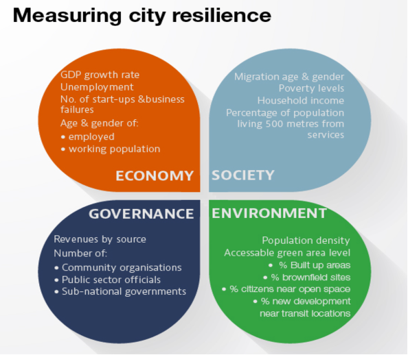
At the macro level, the OECD measures resilient cities using the criteria outlined below[4]. Some of these seem an expression of good economic common sense. Others such as ‘% of citizens near open space’ seem a little tentative and debatable as to their links to resilience.


Four areas that drive resilience. Source: OECD Regional Development[4].

Perhaps as importantly, their definition as to what is resilience is, is tinged with slightly trendy overtones of a ‘brave new world’.

‘Resilient cities are cities that have the ability to absorb, recover and prepare for future shocks (economic, environmental, social & institutional). Resilient cities promote sustainable development, well-being and inclusive growth.’

Sadly, the definition does not really define precisely what the city will be resilient to, rather it is left in vague terms of ‘shock’. It does not mention some of the more critical resilience issues lower down on Maslow’s hierarchy (1943 version; cited by McLeod 2022)[5] such as power, housing, water, sewage, defence, health, and food, without which the ability to live ‘500 metres from services or near an open space or well-being and inclusive growth’ might appear somewhat academic.

At the opposite end of the resilience spectrum, at the individual level, a simple google search of ‘personal resilience course’, offers a spectacular array of over 82 million results. A brief survey of the top five of them indicates that their duration is one day or in some cases half a day. The general view is that personal resilience is a skill or attribute that can be acquired in about 8 hours (the extreme min/max range for the duration of such courses appears to be 90 minutes to a 12-week period).

Robertson et al. (2015) expressed some reservations as to the evidence of the efficacy of such courses. Naturally since 2015 more evidence might be apparent but truly longitudinal studies of the ongoing effect of course completed a decade ago are yet to be available. Their practitioner notes state that,

‘Despite conceptual and theoretical support for resilience training, the empirical evidence is tentative, with the exception of a large effect for mental health and subjective well-being outcomes.’[6]

One BBC report cites Dr Michael Pluess from Queen Mary University of London who is testing for the resilience gene, in which case if discovered it would potentially invalidate the courses cited above.

There is a real danger that resilience, which is a fundamentally practical issue at both the macro and micro level is suborned by the burgeoning but evidentially limited literature on resilience’s relationship to well-being, inclusivity, and mental health. Such links also veneer the unpalatable hard choices that real resilience demands. Put as simply as possible we all might live near open spaces and be very inclusive, but if London’s water supply remains dependent solely on abstraction from the rivers Thames and Lee[7] then it does not matter how ‘positive’ you might feel about the City in about 20 years you will not have enough to drink (perhaps counterintuitively based on a multi-year average, London has only 100mm more rainfall than Jerusalem)[8].

Semantic Satiation

But is there any evidence that the overuse of a word diminishes somehow its value. Broadly speaking yes there is, and it is technically called ‘semantic satiation’. Smith and Klein (1990) noted that ‘Prolonged repetition of a word results in the subjective experience of loss of meaning, or semantic satiation’[9]. At risk of oversimplifying their diligent study, it works something like this; on a relatively infrequent basis I inform my partner that I love her. It seems to cheer her up. If I informed her of my love on a daily basis she would be delighted for a while, then she would suspect that I am having an affair, then she would get bored with it and then perhaps later even angry. The phrase would become increasingly less meaningful and impactful.

At a more serious level it does seem to me to do some harm. In reality a lot of ‘building resilience’ is really risk mitigation or some type or diversification in the case of supply chains. If for instance, we take Markovic’s 1952 diversification theory[10] (disputed by later critics) it does supposedly make an investment portfolio more resilient to market volatility, but the critical issue or activity is diversification which is a ‘thing’ in its own right with a word all of its own to describe it. Now one can make the argument that the end result is a more resilient portfolio, but one should not be tempted to change resilience to an activity which requires it to be a verb. Diversify is the verb or ‘doing word’; resilience is the result. Similarly, if we claim that all activities are resilience measures it somehow diminishes the utility or worth of risk assessments, risk mitigation, plans and responses all of which combine to achieve resilience.

Conclusion

It might be easy to dismiss these concerns as semantic academic posturing yet the power of words, their definitions, associations, and nuances are what will shape the future of resilience. I would wish resilience to remain practical, efficacious, and most importantly simple. Let us leave resilience as an ambition or end state that is achieved through an array of distinct professional activities. Let us also ensure that the fundamental hard and often costly problems associated with resilience are not whitewashed with an ephemera of pleasantries normally found at the higher altitudes of Maslow’s hierarchy of needs. There may well be benefits to stress or coping management courses but let us call them just that, not personal resilience.


Dr Chris Needham-Bennett is Managing Director at Needhams1834 Ltd and Visiting Professor at University College London.

Email Chris at: chris@needhams1834.com


References

[1] Alexander, D. E.: Resilience and disaster risk reduction: an etymological journey, Nat. Hazards Earth Syst. Sci., 13, 2707–2716, https://doi.org/10.5194/nhess-13-2707-2013, 2013.

[2] https://ensia.com/articles/what-is-resilience/

[3] Moser, S., Meerow, S., Arnott, J. et al. The turbulent world of resilience: interpretations and themes for transdisciplinary dialogue. Climatic Change 153, 21–40 (2019). https://doi.org/10.1007/s10584-018-2358-0

[4] https://www.oecd.org/cfe/regionaldevelopment/resilient-cities.htm

[5] McLeod, S. A. (2022, April 04). Maslow’s hierarchy of needs. Simply Psychology. www.simplypsychology.org/maslow.html

[6] Robertson, I.T., Cooper, C.L., Sarkar, M. and Curran, T. (2015), Resilience training in the workplace from 2003 to 2014: A systematic review. J Occup Organ Psychol, 88: 533-562. https://doi.org/10.1111/joop.12120

[7] https://web.archive.org/web/20150325074128/http://www.london.gov.uk/sites/default/files/water-strategy-oct11.pdf

[8] https://www.sdjewishworld.com/2011/11/20/rain-in-jerusalem-almost-as-much-as-london/

[9] Smith, Lee, Klein, Raymond Evidence for semantic satiation: Repeating a category slows subsequent semantic processing. Journal of Experimental Psychology: Learning, Memory, and Cognition, Vol 16(5), Sep 1990, 852-861

[10]  Portfolio Selection, Harry Markowitz – The Journal of Finance, Vol. 7, No. 1. (Mar., 1952), pp. 77-91


Inclusion, Intersectionality, and the Humanitarian Shelter Sector

By Mhari Gordon, on 4 July 2022

Mhari Gordon is an IRDR PhD Student.


The 28th UK Shelter Forum (UKSF) in May 2022 included thought-provoking talks by practitioners and academics on whether the humanitarian shelter sector is ready to respond to the effects of climate change. The ‘Climate Charter’ emphasises the need to “support those who are the most at risk, taking into account the influence that individual characteristics… have on people’s capacities and vulnerabilities.” The importance of inclusive approaches is widely recognised by humanitarian organisations, but how should they put this commitment into practice? At the UKSF Phil Duloy from FCDO chaired a breakout group exploring opportunities for the shelter sector to be more inclusive and intersectional in its approach to the climate crisis. The panel included Hayley Capp from CARE International UK, Kevin Blanchard from DRR Dynamics and Maria Kett from UCL Population Health Sciences.

Photo of Panel including, from left to right, Phil Duloy, Hayley Capp, Kevin Blanchard and Maria Kett. Photo by Ilan Kelman.

Unequal Realities

It has become well-established that individuals are affected by crises and disasters to different extents and that, simply put, the marginalised and minority populations are ‘hit the hardest’. There are numerous examples of double injustices whereby certain individuals are marginalised and experience higher levels of poverty due to social, gender, sexuality, or cultural norms and are therefore more susceptible to the effects of climate change. Capp shared specific examples in the case of women and girls. Women tend to have limited access to and control of resources such as mobile phones, cash transfers, and insurance mechanisms. These resources are important during crises as they foster disaster resilience and recovery. Additionally, women and girls can be faced with lose-lose situations. For example, on one hand, there may be barriers to mobility for leaving their home and on the other, they may face gender-based violence risks in shelters if there are inadequate divisions or security considerations. These limitations are reflected in disaster statistics, such as the 2014 earthquake and tsunami in Indonesia whereby females accounted for two-thirds of the deaths. So, this leads to bigger questions such as how does the shelter sector deal with the underlying reasons and situations which have created such vulnerabilities within its humanitarian response?

Intersectionality and Labels

The use of the ‘intersectionality’ concept, which can recognize personal identities and characteristics, is offered as a framework to understand how different groups experience vulnerability, exposure, and resilience. However, this is not an easy task. Kett observed that even when the intersectionality framework is used within humanitarianism, there is still the presence of ‘silo-ing’ and that the sector does not “necessarily have the tools yet to really operationalise this on the ground.”. The categorisations of gender, sexuality, age, disability, etc., disenable an individual from being truly reflected. It can lose nuances such as a woman who is queer, elderly, and has hearing difficulties. Moreover, it does not necessarily measure vulnerabilities comparatively. For example, a man with a disability can be less marginalised than a woman without in some social contexts. The context of where the humanitarian assistance is being delivered is crucial to understand.

There needs to be careful consideration of how these individual characteristics are being termed, framed, and assessed; that the labelling does not further emphasise the marginalisation or difference from what is considered ‘mainstream’ or ‘acceptable’ within certain norms. Kate Crawford, a panellist from the preceding Humanitarian Institute Evening Conference, noted that labelling can place the vulnerability onto the individual, instead of recognising that it is the societal system that has created vulnerabilities for them. Additionally, there is a danger that labels may create further risks for individuals; for example, if the national state does not recognise an ethnicity. This leads to several ethical questions. How willing are people to be (self-) enumerated? What if an individual has a ‘characteristic’ they are able or want to hide, but it is a determinant of being more vulnerable?

Next Steps

These discussions raise questions about how to put into practice the first commitment of the Climate Charter on supporting those most at risk whilst accounting for individual characteristics and situations, as well as the third commitment on inclusive participation of people in humanitarian programmes. From the opinions shared by the panellists, there are currently few success stories of vulnerable people or minority groups being meaningfully included in wider humanitarian responses, expect where the specific aim of the project had a particular focus on inclusion. However, there remains only limited inclusion mainstreaming in humanitarian projects. Moreover, inclusion frameworks are largely missing in disaster policies. Blanchard identified that there are presently six countries that actively include LGBTQIA+ people in disaster risk reduction (DRR) policies. Additionally, the concept of inclusion is largely missing from the UNDRR Sendai Framework thus leaving a desert in disaster policies. So, what does this mean in terms of the humanitarian response to present and future disasters? How can we better represent inclusion frameworks within wider policies and, most importantly, ensure their application on the ground?

The panellists shared that there is still an opportunity for using the intersectionality framework when well applied, as it can collect representative data of the diversity in our communities. Moreover, intersectionality can also identify tools and knowledge that communities need to respond to vulnerabilities and foster resilience. This would help to design appropriate humanitarian shelter responses for people in need. However, the intersectionality framework may face barriers. Some characteristics, such as ethnicity or sexual orientation, can be protected in one country and legal cause for persecution in another. Therefore, not all data sets represent the most marginalised or at-risk people. Social protection schemes, also known as public safety net programmes, have previously been used in humanitarian responses in the form of increased cash transfers or disability allowances to support more vulnerable individuals during disasters. However, if certain individuals are excluded from beneficiary lists (data sets), there is the danger that they are further marginalised during the humanitarian and disaster response. This example highlights how certain data presentations can lead to pitfalls of not reaching individuals most in need during disasters. Furthermore, it demonstrates the difficult task at hand for humanitarian assistance to reach those most at risk, whilst working with and respecting the sovereignty of the host nation. Therefore, it is paramount that attention is paid to how the data is collected and stored – especially for hyper-marginalised groups – as well as how data is analysed and used.

The key suggestion made by the panellists was to work with existing support groups that are either in the country or the region. Networks such as women’s rights groups, disabled people’s organisations, or LGBTQIA+ groups already contain a wealth of knowledge and strong social networks that can identify those most in need whilst doing it in a safe manner. The caveat is that these groups are typically underfunded and work with limited resources. However, this avenue presents an opportunity for the shelter sector to work with and support local-level actors whilst driving a more inclusive humanitarian response to ensure that no one gets left behind.


More details on the 28th UK Shelter Forum (including videos of several sessions) can be found here: https://www.shelterforum.info/uk-shelter-forum-28-climate-change/

The Martian Residual Crustal Magnetic Fields: A Mitigation Measure Against Space Radiation to Astronauts?

By Joshua Anthony, on 22 October 2021

Author: Shiba Rabiee, recent postgraduate student from IRDR, UCL. Shiba.rabiee.20@ucl.ac.uk | Linked In


Mars is approximately half of the size of Earth and is the fourth planet from the Sun. Due to its many similarities with Earth, Mars is argued to be the second most habitable planet in our solar system. The definitive goal has, therefore, always been a human exploration mission on Mars. After decades of research and space agencies working towards this goal, the founder of SpaceX, Elon Musk, announced in an interview that by 2026 they would be able to send astronauts to Mars in cooperation with NASA [1].

However, in deep space astronauts are exposed to dangerous levels of space radiation (i.e. Galactic Cosmic Radiation and Solar Energetic Particles), and Mars is no exception despite its similarities with Earth. In contrast to Earth’s dense atmosphere enabled by its global dipole magnetic field, Mars has residual crustal magnetic fields that cause a very thin atmosphere (~1% of Earth’s) [see Illustration 1] [2, 3]. This creates a highly radioactive and complex environment on Mars that has detrimental, and ultimately lethal, effects for astronaut’s health [3-5].

(Illustration 1. Source: Shiba Rabiee [panel a., created in Microsoft Word]; Kevin M. Gill [panel b., with modifications by Shiba Rabiee]. Cartoon illustrating the global dipole magnetic field of Earth (panel a.) and the residual crustal magnetic fields of Mars (panel b.)).

Throughout the years of sending astronauts into Low Earth Orbit (160-1000 km altitude above Earth), medical doctors and psychiatrists working with astronauts have noticed a decrease in their holistic health when operating a space mission [6, 7]. Space agencies have, therefore, several times encouraged engineers to develop mitigation measures for high radiation exposure but without much success. Shielding measures are essential, yet many issues arise with the creation of shielding such as high financial expense, how to transport the shielding to Mars, and how the material(s) will act in the Martian environment. Space radiation is, therefore, generally acknowledged as a potential barrier for human exploration missions both during Cruise-Phase and whilst on a planet or moon [8].

As space agencies try to create innovative solutions for spacecrafts and crewmembers during Cruise-Phase for a Mars mission, bigger challenges await when arriving on the red planet. A mission to Mars would require astronauts to stay on the planet for several weeks due to the distance between Mars and Earth. In combination with the Martian environment, long-duration space exploration poses several risks and increases the vulnerability to multiple hazards amongst both crewmembers and spacecrafts. Thus, in order to ethically send astronauts to Mars, the radiation problem has to be solved. Research to investigate the mitigation of radiation exposure and associated risks is important to protect good health.

The complexity of creating and transporting affordable mitigation measures has left space agencies with the question of whether to use resources from the Martian environment. A promising mitigation measure currently being discussed is the use of the Martian regolith as a shielding measure by creating a habitat of tunnels beneath the surface of Mars. Yet, this will not provide shielding for astronauts undergoing an extravehicular mission (spacewalk). A human exploration mission will, however, demand exploration of the Martian environment outside the habitat. The need for further investigation and the development of additional mitigation measures, therefore, remains.

The objective of my thesis was to investigate the use of the residual crustal magnetic fields of Mars as a mitigation measure against space radiation exposure during e.g., extravehicular missions. Research on the magnetic fields have been previously conducted [8-16], wherefrom the general argument is that the Martian atmosphere and the magnetic fields provide an equal amount of shielding against space radiation [8] [16]. Yet, these were founded on hypotheses as the Martian atmosphere was not considered during the simulation models [8]. Thus, it was unknown whether the atmosphere could, in fact, provide corresponding shielding measures.

The Martian atmosphere has roughly two orders of magnitude smaller column density than that of Earths and comprises ~95.1% carbon dioxide [16-19]. This, in combination with continuing atmospheric escape, causes the Martian atmosphere to provide almost no shielding against space radiation. Depending on the solar cycle and the chosen location, the estimations conducted for the thesis does, however, imply a potential prolonged extravehicular mission of e.g., ~34 sec/day to ~74 min/day within a field strength of 14 nT [see magnetic fields strength map for the range of field strengths measured at 400 km altitude]. These estimates will increase with increasing field strengths, thus, indicating that the residual crustal magnetic fields can be used as a mitigation measure. Moreover, the estimates imply a significant difference between shielding provided by the atmosphere and the residual crustal magnetic fields.
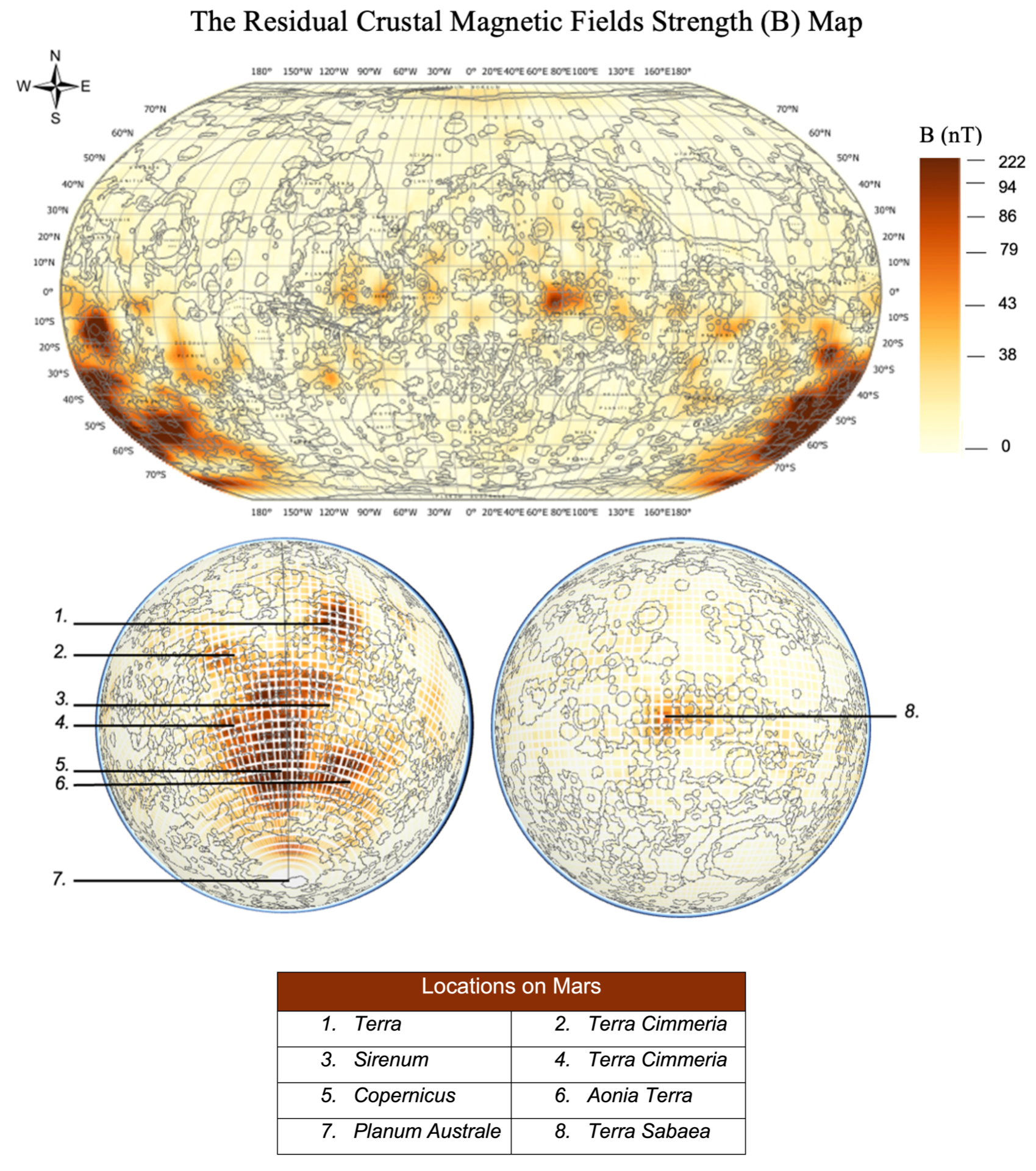
(Illustration 2. Source: Shiba Rabiee. Data source: Planetary Geologic Mapping Program; The Planetary Data System; the ArcGIS ESRI geodatabase. Map presenting the residual crustal magnetic field strengths measured by Mars Global Surveyor at 400 km altitude).

This conclusion is founded on methods and various assumptions. To confirm the results presented, further investigation of the residual crustal magnetic fields needs to be completed. Suggestions for potential future missions and research has, therefore, additionally been presented and discussed in the thesis.

Mars has been argued to have looked very similar to Earth ~3.8 billion years ago [see Illustration 3] [20]. Further investigations of the residual crustal magnetic fields of Mars will not only enable an understanding of its potential to act as a shielding measure, but similarly to Mars, atmospheric escape can also be found on Earth. Yet, despite long investigations of Earth’s atmospheric escape many questions remain unanswered. A comprehensive investigation of the residual crustal magnetic fields and its relation to the Martian environment could, therefore, inform about the core of Mars and the planets atmospheric escape, consequently enabling an understanding of the atmospheric leakage on Earth. Research in this area may provide essential information of what could be the future of Earth.

(Illustration 3. Source: Kevin M. Gill [modifications by Shiba Rabiee]. Depiction of the evolution of Mars from ~3.8 billion years ago (left) to the Martian environment today (right)).


Shiba Rabiee is a recent postgraduate student from IRDR, UCL. Email at Shiba.rabiee.20@ucl.ac.uk| Linked In


References

[1] Wall, Mike (2020): SpaceX’s 1st crewed Mars mission could launch as early as 2024, Elon Musk says. SPACE.com. https://www.space.com/spacex-launch-astronauts-mars-2024 [Accessed 17.02.2021].

[2] Matthiä, Daniel; Hassler, Donald M.; Wouter de Wet; Ehresmann, Bent; Firan, Ana; Flores-McLaughlin, John; Guo, Jingnan; Heilbronn, Lawrence H.; Lee, Kerry; Ratliff, Hunter; Rios, Ryan R.; Slaba, Tony C.; Smith, Micheal; Stoffle, Nicholas N.; Townsend, Lawrence W.; Berger, Thomas; Reitz, Günther; Wimmer-Schweingruber, Robert F.; Zeitlin, Cary (2017): The radiation environment on the surface of Mars – Summary of model calculations and comparison to RAD data. Life Science in Space Research, Volume 14. pp. 18-19.

[3] Hassler, Donald M.; Zeitlin, Cary; Wimmer-Schweingruber, Robert F.; Ehresmann, Bent; Rafkin, Scot; Eigenbrode, Jennifer L.; Brinza, David E.; Weigle, Gerald; Böttcher, Stephan; Böhm, Eckart; Burmeister, Soenke; Guo, Jingnan; Köhler, Jan; Martin, Cesar; Reitz, Guenther; Cucinotta, Francis A.; Kim, Myung-Hee; Grinspoon, David; Bullock, Mark A.; Posner, Arik; Gómez-Elvira, Javier; Vasavada, Ashwin; Grotzinger , John P.; MSL Science Team (2014): Mars’ Surface Radiation Environment Measured with the Mars Science Laboratory’s Curiosity Rover. Science. Volume 343, Issue 6169, 1244797. pp. 1-6.

[4] National Aeronautics and Space Administration [NASA] (2020): What is space radiation?. NASA. https://srag.jsc.nasa.gov/spaceradiation/what/what.cfm [Accessed 08.08.2021].

[5] National Aeronautics and Space Administration [NASA] (2019): NASA’s MMS Finds Its 1st Interplanetary Shock. NASA. https://www.nasa.gov/feature/goddard/2019/nasa-s-mms-finds-first-interplanetary-shock  [Accessed 08.08.2021].

[7] Kennedy, Ann R. (2014): Biological effects of space radiation and development of effective countermeasures. Life Sciences in Space Research. Volume 1. DOI: 10.1016/j.lssr.2014.02.004. pp. 10-43.

[8] Durante, Marco (2014): Space radiation protection: Destination Mars. Life Sciences in Space Research. Volume 1. DOI: 10.1016/j.lssr.2014.01.002. pp. 2-9.

[9] Acuña, M.H.; Connerney, J.E.P.; Wasilewski, P.; Lin, R.P.; Anderson, K.A.; Carlson, C.W.; McFadden, J.; Curtis, D.W.; Mitchell, D.; Reme, H.; Mazelle, C.; Sauvaud, J.A.; d’Uston, C.; Cros, A.; Medale, J.L.; Bauer, S.J.; Cloutier, P.; Mayhew, M.; Winterhalter, D.; Ness, N.F. (1998): Magnetic Field and Plasma Observations at Mars: Initial Results of the Mars Global Surveyor Mission. Science. Volume 279, Issue 5357. DOI: 10.1126/science.279.5357.1676. pp. 1676-1680.

[10] Acuña, M. H.; Connerney, J.E.P.; Ness, N.F.; Réme, H.; Mazelle, C.; Vignes, D.; Lin, R.P.; Mitchell, D.L.; Cloutier, P.A. (1999): Global distribution of crustal magnetization discovered by the Mars Global Surveyor MAG/ER experiment.Science. Volume 284, Issue 5415. DOI: 10.1126/science.284.5415.790. pp. 790–793.

[11] Hiesinger, Harald; Head III, James W. (2002): Topography and morphology of the Argyre Basin, Mars: implications for its geologic and hydrologic history. Planetary and Space Science. Vol. 50, issues 10-11. https://www.sciencedirect.com/science/article/abs/pii/S0032063302000545. pp. 939-981.

[12] Mitchell, D.L.; Lillis, R.J.; Lin, R.P.; Connerney, J.E.P.; Acuña, M.H. (2007): A global map of Mars’ crustal magnetic field based on electron reflectometry. Journal of Geophysical Research 2007. Vol. 112, EO1002. Doi: 10.1029/2005JE002564. pp. 1-9.

[13] Dartnell, L.R.; Desorgher, L.; Ward, J.M.; Coates, A.J. (2007): Martian sub-surface ionizing radiation: biosignatures and geology. Biogeosciences. Volume 4, Issue 4. DOI: https://doi.org/10.5194/bg-4-545-2007. pp. 545-558.

[14] Lesur, V., Hamoudi, M., Choi, Y., Dyment, J., & Thébault, E. (2016). Building the second version of the World Digital Magnetic Anomaly Map (WDMAM). Earth Planets Space, 68, 27. https://doi.org/10.1186/s40623-016-0404-6. pp. 1-13.

[15] Langlais, Benoit; Thébault, Erwan; Houliez, Aymeic; Purucker, Micheal E.; Lillis, Robert J. (2019): A New Model of the Crustal Magnetic Field of Mars Using MGS and MAVEN. Journal of Geophysical Research: Planets. Volume 124. DOI: https://doi. org/10.1029/2018JE005854. pp. 1542-1569.

[16] Carr, M.H. (1996): Water on Mars. Oxford University Press. Environmental Science, Physics Bulletin. Volume 38. DOI: https://doi.org/10.1088/0031-9112%2F38%2F10%2F017. pp. 374-375.

[17] Jakosky, B.M.; Slipski, M.; Benna, M.; Mahaffy, P.; Elrod, M.; Yelle, R.; Stone, S.; Alsaeed, N. (2017): Mars’ atmospheric history derived from upper-atmosphere measurements of 38Ar/36Ar. Science. Volume 355, Issue 6332. DOI: 10.1126/science.aai7721. pp. 1408-1410.

[18] Nier, A.O.; Hanson, W.B.; Seiff, A.; McElroy, M.B.; Spencer, N.W.; Duckett, R.J.; Knight, T.C.D.; Cook, W.S. (1976): Composition and Structure of the Martian Atmosphere: Preliminary Results from Viking 1. Science. Volume 193, Issue 4255. DOI: 10.1126/science.193.4255.786. pp. 786-788.

[19] Nier, A.O.; McElroy, M.B. (1977): Composition and Structure of Mars’ Upper Atmosphere: Results From the Neutral Mass Spectrometers on Viking 1 and 2. AGU. Journal of Geophysical Research. Volume 82, Issue 28. DOI: https://doi.org/10.1029/JS082i028p04341. pp. 4341-4349.

[20] National Aeronautics and Space Administration [NASA] (2017): The Look of a Young Mars. NASA.https://www.nasa.gov/content/goddard/the-look-of-a-young-mars-3 [Accessed 25.08.2021].

Illustrations and Map

Gill, Kevin M. [modified by Shiba Rabiee] (2015): Mars. Flickr. https://www.flickr.com/photos/53460575@N03/16716283421 [Accessed 13.10.2021].

ArcGIS: ESRI geodatabase – ESTRI_ASTRO. https://www.arcgis.com/home/user.html?user=esri_astro [Accessed: 10.05.2021].

NASA: Planetary Data System. https://pds-ppi.igpp.ucla.edu/search/?t=Mars&facet=TARGET_NAME [Accessed: 27.05.2021].

USGS; NASA: The Planetary Geologic Mapping Program. https://planetarymapping.wr.usgs.gov [Accessed: 04.05.2021].

Gill, Kevin M. [modified by Shiba Rabiee] (2015): Evolution of Mars. Flickr. https://www.flickr.com/photos/53460575@N03/17234143751 [Accessed 14.10.2021].

WHO Classification for Emergency Medical Teams: A Step in the Wrong Direction?

By Navonel Glick, on 20 April 2021

National/international medical professionals working together at a clinic in Ormoc, Philippines – a model that is no longer allowed by the current WHO EMT guidelines. Photo Credit: Boaz Arad/IsraAID (2013)

In 2013, Typhoon Haiyan devastated the Philippines and galvanised the international community. Organisations, like the American Red Cross, sent full-scale field hospitals. Others, like IsraAID, despatched medical personnel and supplies, providing surge capacity to local clinics.

Integrating external resources into existing healthcare systems is an effective strategy, with potential long-term benefits. Yet, while such activities may be a model for integrating disaster risk reduction into response, World Health Organization (WHO) guidelines do not permit them.

The WHO classification system was created to counter the variation “in capacities, competencies and adherence to professional ethics” amongst Emergency Medical Teams (EMTs). Each of the three approved EMT types must operate independently and be self-sufficient for 2–4 weeks. This emphasis on independence avoids ‘burdening’ affected populations, but it leaves no room for interventions to support national/local healthcare institutions.

In fact, the WHO’s 91-page document outlining EMT minimum standards contains no reference to existing healthcare systems, let alone strategies for cooperation. This omission perpetuates the myth that ‘helpless’ disaster-affected people need international organisations to ‘save them’, instead of recognising that disaster response is often locally driven. Further, EMTs acting alone face avoidable linguistic, cultural, and logistic obstacles that hamper the quality of care provided. Setting up alternative healthcare locations, pathways, and practices may also sow confusion, thus increasing long-term vulnerability by undermining trust in the healthcare system.

Efforts to standardise EMTs and rout out malpractice and disaster tourism are welcome. But the WHO guidelines sadly disregard successful integrated models, like IsraAID’s, instead promoting foreign intervention over local capacity and prevention. If only the WHO abided by their own Health Emergency and Disaster Risk Management framework.

Corona Wars: The Cost of Calling Disasters ‘Wars’

By Patrizia Isabelle Duda, on 4 May 2020

Written by Patrizia Isabelle Duda and Navonel Glick

War on Coronavirus poster

On March 17th, U.S. President Trump began calling the Covid-19 pandemic a “war”, to wide acclaim by supporters and scathing condemnation by critics.

The reasons for using the war metaphor are straightforward. By calling the pandemic a war, Trump is appealing to a familiar scenario that we feel we ‘know’ how to relate to. It ostensibly simplifies the crisis, mobilises the public, and calls for unity.

The war metaphor is a powerful and effective tool that is often used in politics, but it is also pervasive in the world of disaster risk reduction and response. The historical links between disaster management and the military are well-documented. Today, from operational frameworks like the Incident Command System (ICS) that were inspired by military management structures, to the extensive use of military terminology like ‘deploy’, ‘mission’, or ‘surge’ by even the most ‘military-averse’ NGOs (e.g. IRC, Plan International), the connection remains.  Even the widely revered (and much maligned) ‘logical framework’, meant to improve transparency and accountability in the aid sector, originated in planning approaches for the U.S. military.

At first glance, the war metaphor makes sense. The chaotic images from disaster areas that make the headlines are reminiscent of war zones, and the associated urgent, high-stress, life-and-death decisions demand composure, bravery, and decision-making attributes that we have learned to equate with our armed forces.

Yet, the analogy quickly crumbles. For one, as most disaster practitioners would confirm, the period immediately following a disaster which might require such an approach, at best, represents only a fraction of any disaster response effort, let alone long-term recovery or disaster risk reduction (through sustainable development).

In addition, as our experience in the field shows, armed forces are notoriously poor at interacting with vulnerable civilian populations, particularly in complex situations of unrest. More importantly, the war analogy is plagued by a core contradiction. While it can be argued that armies engage in war to ‘defend’ or ‘protect’ a population, destruction is often their main tool for doing so. This is not what disaster response or humanitarian aid are about, much less how one reduces disaster risks and builds disaster-resilient communities.

So why does the war metaphor continue to dominate the field? The simple answer may be because it works. It appeals to the pleasure-pain principle, triggers our basic fight-or-flight instincts, and provokes a reaction.

Yet, this strategy may be poorly suited to pandemics. We rightfully celebrate our health-care workers and other front-line personnel as ‘heroes’—yet another war term—and many of them may be faced with ‘war-like’ situations of urgency and life-and-death situations. But for the rest of us, “wash your hands” and “stay at home” are woefully anti-climatic ‘weapons’ to ‘fight’ the ongoing coronavirus ‘enemy’.

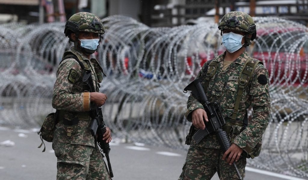
Photo credit: hairul_nizam / Shutterstock.com

Furthermore, the ‘war metaphor’ may succeed in the short-term during a crisis, but such bursts of energy (or adrenaline) cannot be maintained over time. Pandemics are not addressed by acute, short-term measures or bursts of adrenaline, but instead, by a complex web of systematic health and public health initiatives, drawn out over a long period of time.

The most damning trait of the war metaphor is, therefore, the focus on the disease itself, instead of the systemic issues that allowed it to become a pandemic. Diseases, much like earthquakes or hurricanes, are natural hazards. They only become disasters when we are left exposed and vulnerable to them by insufficient preparedness and poor risk reduction measures. Thus, tackling the underlying social, economic, and political systemic issues that drive disaster vulnerability should be our priority.

The analogy of a marathon instead of a sprint comes to mind, except that in this case the race has no end. In fact, it never was a race to begin with. This may be the biggest fallacy with using the war metaphor for disasters: wars are arguably won or lost; at least they (should) end. Disaster preparedness and reducing risks do not—they are an ongoing process of achieving and maintaining sustainable practices.

The war metaphor, therefore, from the very beginning, begs to disappoint, because there will not be the closure it promises. Calling our health workers and other frontline workers ‘life-saving heroes’ is an admirable title they deserve, but were they any less worthy of it before the pandemic? And will they not continue to perform the same essential role once the coronavirus pandemic has passed?

In this time of acute crisis, when the lack of preparedness and risk reduction is painfully exposed, we may be glad to have the war metaphor for the action that it catalyses. But by continuing to prioritise response over prevention, and perpetuating the myth of the ‘race’, what social habits will we continue to reinforce, and at what cost?

What would an alternative look like?

Conflict, Disaster, and Disease: A Colossal Catastrophe Looms in the Rohingya Camps in Cox’s Bazar, Bangladesh

By Bayes Ahmed, on 20 April 2020

A panoramic view of the Kutupalong Rohingya camp in Cox’s Bazar district, Bangladesh. Source: Bayes Ahmed, fieldwork, 2019.

On 17 April 2020, another boat floating in the Bay of Bengal for two months was found carrying 30 dead bodies and 400 other Rohingya refugees, mostly women and children, fleeing armed conflict from Myanmar. Also, since 23 March 2020, the Myanmar military has been carrying out daily airstrikes and shelling in Rakhine State resulting in at least 32 civilian deaths, mostly women and children, and destroying homes and schools. The killing of innocent people and civilians by the Myanmar Army/Tatmadaw in Rakhine is still taking place fearlessly despite the International Court of Justice (ICJ), the principal judicial organ of the United Nations (UN), officially endorsed the ‘Rohingya identity’ in January 2020 and ordered the Myanmar government not to commit acts of genocide and take effective measures to prevent the destruction of any evidence related to genocide. The final verdict on the prevention and punishment of the Crime of (Rohingya) Genocide against Myanmar is pending.

The crisis is not new. The Rakhine State of Myanmar and Cox’s Bazar District of Bangladesh share international borders, and both countries were commonly ruled by the British Empire. Being the same colony for over 120 years, eventually, the Muslim Bengalis and Buddhist Rakhine people travelled between the two states (formerly known as the Arakan State) for business, agricultural and other purposes. However, since the independence of Burma in 1948, the Muslim population in Rakhine have been labelled as ‘illegal Bengali migrants’ and later on referred to as the Rohingyas. Failing to permanently expel the Rohingyas from Rakhine, the Burmese (Military) government, introduced a citizenship law in October 1982 stating that “full citizens are descendants of residents who lived in Burma prior to 1823 or were born to parents who were citizens at the time of birth”. The amended law has a clear link with the Muslim migration during the British rule in Burma between 1824-1948. Eventually, the Rohingyas lost their citizenship and became stateless.

Since then persistent torture, human rights violation and persecution followed by a number of major military crackdowns, a genocidal policy adopted by the Myanmar Army, communal violence between Muslims and Buddhists in Rakhine, and killing and murder of innocent civilians and burning down their homestead resulted in the forced displacement of Rohingyas to Bangladesh notably in 1978, 1992, 2012, 2016, 2017, and in 2019. Recently, Médecins Sans Frontières (MSF) estimated that at least 6,700 people lost their lives due to direct violence in Myanmar between 25 August and 24 September 2017. The UN estimates that over one million stateless Rohingya are still remaining in Rakhine State (600,000 displaced and 470,00 non-displaced). The actual number is unknown due to fabrication in Myanmar’s national population census and strategically replacing the names of local villages/townships. The Rohingyas are facing extreme discrimination and are being denied basic humanitarian access, livelihoods and services in Myanmar. In contrast, Bangladesh is currently hosting over 860,000 Rohingyas (78% of them are women and children) in the UN registered camps in Cox’s Bazar and over 300,00 of them are hiding as undocumented refugees. The crisis has adversely impacted more than 444,000 Bengali host community members in Cox’s Bazar.

An enormous protected area of hill forests in Cox’s Bazar district (6,000 hectares) has already been wiped out to build makeshift shelters by cutting hills and to arrange fuel for cooking for the Rohingyas. They are living in camps that are absolutely vulnerable to landslides, flash flooding, cyclones, and fire hazards. Between April to November 2019, at least 1400, 500, 70, and 35 major incidents were reported across all camps related to landslide/soil erosion, wind/storm, flood, and fire hazard respectively. As a result, over 85,000 individuals were affected and 4,000 households were displaced to another location. No effective early warning system is available for them, although the partners are consistently working to make the camps weather-proof and resilient to natural hazards.

Multi-hazard prone Rohingya makeshift camps in Cox’s Bazar district, Bangladesh. Source: Bayes Ahmed, fieldwork, 2018-2020 and Inter Sector Coordination Group (ISCG), 2019.

The Rohingyas in Cox’s Bazar are not allowed to move outside the camps and build permanent shelters. No formal education is also allowed. They depend on nominal humanitarian assistance from the UN such as basic food (rice, palm oil, and lentils). These embargos are imposed mostly to comply with the standard UN refugee mandates. The novel Coronavirus (COVID-19) pandemic is posing another major threat to the Rohingyas, as they are living in exceedingly overcrowded camps and the existing health centres are not equipped with necessary testing and treatment facilities. The same situation applies to the host communities. As instructed by the UN, the partners are advancing with the construction of an isolation and treatment centres, reducing activities to essential services and assistances only, promoting hygiene activities, training healthcare workers, and ensuring social distancing inside the camps. As of 20 April 2020, the entire Cox’s Bazar district including the camps are now locked down, and no Rohingya is even allowed to move between two camps until further notice.

Activities are undertaken to prevent COVID-19 outbreak in the Rohingya camps in Cox’s Bazar district, Bangladesh. Source: Inter Sector Coordination Group (ISCG), 2020.

The Rohingyas are also afraid to go back to Myanmar as they suspect fresh attacks on them by the Myanmar Army. The repatriation process is halted. The Rohingyas have strong community bonding and trying their best to adapt in this dreadful situation, however, all these efforts are not enough to ensure resilient futures for them. Given the international and national resolutions, the only sustainable solution for the Rohingya refugees would be to repatriate them in Myanmar with safety and dignity. 

Overall, the genocide-fled Rohingyas and already over-stressed Bangladeshi host communities in Cox’s Bazar are not ready to face the impending threats of natural hazard-induced disasters and Coronavirus pandemic. If, for example, a landslide/cyclone disaster and COVID-19 outbreak collide in the coming months, then it would be another catastrophic humanitarian crisis. The threat is inevitable, but nobody knows any decisive remedy to tackle it. Now, we can only pray for a strong cyclone or consecutive torrential rainfall events not to occur during the cyclone and monsoon season (May-November) or the Coronavirus not to spread in the Rohingya camps in Cox’s Bazar. Yet, there is no hope for their sustainable repatriation, integration, third-country settlement, or justice. The situation is somewhat true or even worse for the remaining 70 million displaced people worldwide – their sufferings have no limits!

Even a pod of whales can travel from the Indian to the Atlantic Ocean, a flock of birds can fly from one continent to the other, but unfortunately, we have created such a sickening (in)human civilisation where a group of distressed people fleeing war, conflict, climate change and natural disasters are not allowed to move freely or even claim basic human rights for their minimal level of survival. This is the bitter truth! The only long-lasting solution to this grave crisis would be to fully support global truce (including the insurgents and militias), end hatred and discrimination towards minority and refugee population, and promote peace, sustainable economic growth, and global and regional cooperation gradually.

Rohingya camps in the no man’s land in Tumbru, Naikhongchari Upazila, Bandarban district, Bangladesh. Source: Bayes Ahmed, fieldwork, 2018.

Author: Dr Bayes Ahmed, UCL IRDR

UCL Humanitarian Institute Masterclass: Earth Observation and Natural Hazards

By Saqar ' M Al Zaabi, on 5 March 2020

Written by Dr Akhtar Alam, Research Fellow at UCL IRDR

A masterclass was organised by UCL Institute for Risk and Disaster Reduction (IRDR) on February 20, 2020. Attended by twenty-five researchers, practitioners and students from different institutions, the event included lectures, proactive sessions and a laboratory exercise.

The morning session started with a lecture on the application of Earth Observation (EO) technology in monitoring and mitigating natural hazards, delivered by Aisha Aldosery, a PhD student at UCL IRDR. She presented an overview of the fundamental principles of remote sensing, data products and space programmes. She also discussed the applications of this technology to collect information on various natural hazards.

The second lecture was an illustration of a case study – “Cyclone risk assessment of the Cox’s Bazar district (CBD) in SE Bangladesh”, delivered by Dr Akhtar Alam, Research Fellow at UCL IRDR. He demonstrated the use of EO data, statistical methods and GIS for simulating risk scenarios at varied spatial scales of the study area. He also discussed the issues concerning the availability and selection of the data, uncertainties and limitations of the procedures, and validation of the results in the risk assessment process.

In addition to the conceptual discussions, the participants were given an exercise on risk mapping. The objective was to simulate the spatial patterns of risk with a manual procedure. It imitated the complementary use of EO technology, Geographic Information System (GIS) and Analytic Hierarchy Process (AHP) for mapping the risk. This was an exciting session where participants were divided into groups and engaged in the activity. At the end of the session, they were given a chance to express their views and present the results of the exercise.

The afternoon session was devoted to a GIS exercise in the laboratory.  Original raster data layers were provided to the participants to perform a landslide hazard analysis. The learning outcomes included visualization, interpretation and integration of the standardized raster data layers for weighted overlay analysis in ArcGIS, deriving weights of different parameters and checking the consistency of the weighting process using AHP, and developing a landslide hazard map of the study area from the given data layers.

The participants expressed positive feedback about the event.

Natural Hazards, Conflicts and Disasters in the Himalayan Region

By Saqar ' M Al Zaabi, on 3 March 2020

Written by IRDR Master’s student Ronja Lutz

The UCL Humanitarian Institute evening conference, held on 19 February 2020 and chaired by Prof Peter Sammonds, presented a panel of four speakers giving diverse perspectives on disaster relief in the Himalayan region.

Dr Jessica Field from Brunel University gave the first talk. She introduced the history of disaster relief in India in order to zoom in on the situation in Ladakh. She characterised disaster governance in this region of Northern India as focused on top-down security and military interventions, relief practices as centred on hazards, and being reactive rather than proactive. Of particular interest was her analysis of relief work in the context of different actors, governmental and non-governmental, competing for legitimacy.

The second talk, by Sultan Bhat of Kashmir University, was focusing on factors that make the Kashmir valley vulnerable to hazards such as floods. He then highlighted changes due to tourism, such as deforestation, expanding settlements, that lead to increased vulnerability. In a long-term overview spanning several centuries, he was able to show that not only vulnerability but also the occurrence of floods in the Kashmir valley has increased.

Third up was Dr Punam Yadav from UCL’s Institute for Risk and Disaster Reduction (IRDR), presenting on the conflict in Nepal and its effects on women. She gave an overview of Nepal’s Civil War 1996–2006, in the wake of which around 70,000 people are still displaced. Despite the numerous negative effects of conflict, Dr Yadav pointed out how conflict can create spaces for women. For example, the political representation of women has increased from 6% to 33% after the introduction of a quota in 2007, and 20% of combatant roles in the military are now reserved, arguably due to women’s involvement in civil war combat.

The final talk by IRDR’s Akhtar Alam gave a broader overview of the challenges to disaster risk reduction in the Himalayas in the future. After surveying the numerous natural hazards in the region, including earthquakes, flash floods, and landslides, he pointed out that despite a high occurrence of hazards across the whole region, the vulnerability of certain regions is what ultimately determines fatality rates. For example, Myanmar and Bangladesh saw relatively few incidents compared to other regions, but a very high death toll. Consequently, he urged for increasing resilience to natural hazards, for example by improving and enforcing building standards in the face of earthquake risks. Similar to Dr Field, he cited a focus on response instead of prevention and a neglect of community involvement as obstacles to preventing disasters in the Himalayan region.

The event was live-streamed and you still can watch the video on the Institute for Risk and Disaster Reduction YouTube channel: https://youtu.be/dhYU0MuJf3g