X Close

UCL IRDR Blog

Home

UCL Institute for Risk and Disaster Reduction

Menu

Mapping the world’s largest hidden resource

By Mohammad Shamsudduha, on 15 February 2024

photograph of a water pump in wet agricultural land
Groundwater-fed irrigation in southwest Bangladesh (credit: Ahmed Rahman, UCL IRDR)

Water sustains life and livelihoods. It is intrinsically linked to all aspects of life from maintaining a healthy life, growing food, and economic development to supporting ecosystems services and biodiversity. Groundwater—water that is found underneath the earth’s surface in cracks and pores of sediments and rocks—stores almost 99% of all liquid freshwater on Earth. Globally, it is a vital resource that provides drinking water to billions of individuals and supplies nearly half of all freshwaters used for irrigation to produce crops. But are we using it sustainably?

Abstraction


Groundwater is dug out of subsurface aquifers by wells and boreholes, or it comes out naturally through cracks of rocks via springs. Today, about 2.5 billion people depend on groundwater to satisfy their drinking water needs, and a third of the world’s irrigation water supply comes from groundwater. It plays a crucial role in supplying drinking water during disasters such as floods and droughts when surface water is too polluted or absent. Despite its important role in our society, the hidden nature of groundwater often means it is underappreciated and underrepresented in our global and national policies as well as public awareness. Consequently, A hidden natural resource that is out of sight is also out of mind.

Some countries (e.g., Bangladesh) are primarily dependent on groundwater for everything they do from crop production to the generation of energy. Other countries like the UK use surface water alongside groundwater to meet their daily water needs; some countries (e.g., Qatar, Malta) in the world are almost entirely dependent on groundwater resources. Because of its general purity, groundwater is also heavily used in the industrial sector.

photograph of man taking measurements at a borehole
Measuring groundwater levels in a borehole in Bangladesh by IRDR PhD student Md Izazul Haq

Monitoring


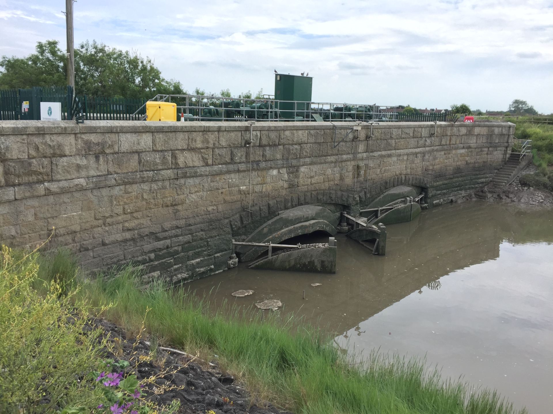
Despite our heavy reliance on it, there is a lack of groundwater monitoring across the world. Monitoring of groundwater resources, both quality and quantity, is patchy and uneven. Developed countries like Australia, France and USA have very good infrastructure for monitoring groundwater. Monitoring is little or absent in many low- and medium-income countries around the world. There are some exceptions as some countries in the global south such as Bangladesh, India and Iran do have good monitoring networks of groundwater levels.

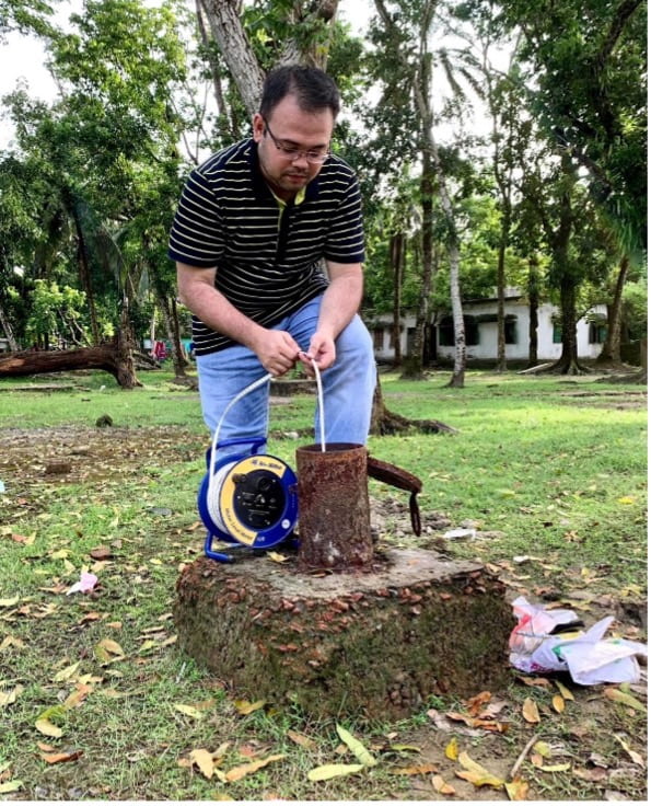
Groundwater storage changes are normally measured at an observation borehole or well manually with a whistle attached to a measuring tape, so when it comes into contact with water, it makes a sound. It can be also monitored by sophisticated automated data loggers. Groundwater can be monitored indirectly using computer models and, remotely at large spatial scales, by earth observation satellites such as the Gravity Recovery and Climate Experiment (GRACE) twin satellite mission. Models and satellite data have shown that groundwater levels are falling in many aquifers around the world because of over-abstraction and changes in land-use and climate change. However, due to lack of global-scale monitoring of groundwater levels, mapping of world’s aquifers has not been done at the scale of its use and management.

Current research


New research published in Nature (Rapid groundwater decline and some cases of recovery in aquifers globally) led by researchers from UCL, University of California at Santa Barbara and ETH Zürich has analysed groundwater-level measurements taken over the last two decades from 170,000 wells in about 1,700 aquifer systems. This is the first study that has mapped trends in groundwater levels using ground-based data at the global scale in such an unprecedented detail that no computer models or satellite missions have achieved this so far. The mapping of aquifers in more than 40 countries has revealed great details of the spatiotemporal dynamics in groundwater storage change.

The study has found that groundwater levels are declining by more than 10 cm per year in 36% of the monitored aquifer systems. It has also reported rapid declines of more than 50 cm per year in 12% of the aquifer systems with the most severe declines observed in cultivated lands in dry climates. Many aquifers in Iran, Chile, Mexico, and the USA are declining rapidly in the 21st century. Sustained groundwater depletion can cause seawater intrusion in coastal areas, land subsidence, streamflow depletion and wells running dry when pumping of groundwater is high and the natural rates of aquifer’s replenishment are smaller than the withdrawals rates of water. Depletion of aquifers can seriously affect water and food security, and natural functioning of wetlands and rivers, and more critically, access to clean and convenient freshwater for all.

The study has also shown that groundwater levels have recovered or been recovering in some previously depleted aquifers around the world. For example, aquifers in Spain, Thailand as well as in some parts of the USA have recovered from being depleted over a period of time. These finding are new and can shed light on the scale of groundwater depletion problem that was not possible to visualise from global-scale computer models or satellites. This research highlights some cases of recovery where groundwater-level declines were reversed by interventions such as policy changes, inter-basin water transfers or nature-based but technologically-aided solutions such as managed aquifer recharge. For example, Bangkok in Thailand saw a reversal of groundwater-level decline from the 1980s and 1990s following the implementation of regulations designed to reduce groundwater pumping in the recent decades.

Groundwater is considered to be more resilient to climate change compared to surface water. Experts say climate adaptation means better water management. Globally, the awareness of groundwater is growing very fast. It has been especially highlighted in the latest IPCC Sixth Assessment Report, the UN World Water Development Report 2022 (Groundwater: Making the invisible visible), the UN Water Conference 2023, and more recently in COP28 (Drive Water Up the Agenda). Groundwater should be prioritised in climate and natural hazard and disaster risk reduction strategies, short-term humanitarian crisis response and long-term sustainable development action.

Read the full nature article.


Dr Mohammad Shamsudduha “Shams” is an Associate Professor in IRDR with a research focus on water risks to public health, sustainable development, and climate resilience.


The views expressed in this blog are those of the author.

Read more IRDR Blogs

Follow IRDR on Twitter @UCLIRDR

The Search for a Natural River

By Joshua Anthony, on 27 January 2023

Following the UK’s exit from the European Union, the legacy leftover from the EU’s Water Framework and Flood Directives, which jointly encourage sustainable management of flood risk, lives on. The UK has seen a number of similar national policy frameworks implemented aiming to reduce flood risk while improving water quality and biodiversity, with over 100 river restoration projects seen in London alone between 2000 and 2019. Most of these efforts are geared towards sustainability in the face of climate change, but, with regards to the long-term, the river itself is often left out of the plans.

The historic human efforts to manage rivers have been progressively called into question over their sustained maintenance costs and an incongruity with environmental and ecological health. An alternative solution is to renaturalise and restore natural processes—reconnecting rivers with their floodplains, reintroducing wild species, run-off targeted tree planting—but this would also be to submit to a changing and dynamic landscape. Rivers can change course—sometimes very suddenly—or silt-up and become unnavigable. True sustainability should therefore account for the long term changes of rivers, but these changes are rarely accounted for in flood risk management policy. As Andrew Revkin asks: “sustain what?”

The problem with “natural”

The problem is partially semantical. The terms renaturalisation, restoration, and rewilding carry with them the image of an implied prior state or a “Lost Paradise”. Ironically, it is precisely the long legacy of human engineering, which some modern schemes are trying to reverse, that denies us the knowledge of a natural state; it is difficult to look into the past, when the waters are so muddied by our imprint. As a result, our ability to assess the future impact of renaturalisation is equally hindered. 

Arguably nowhere in the UK is this problem illustrated better than in the Somerset Levels, which as far back as the roman occupation of Britain has seen artificial drainage and reclamation in order to take advantage of its pastoral and arable potential. At present, the flat, largely reclaimed floodplain relies heavily on a vast network of excavated drainage ditches (rhynes in the local vernacular), sluice gates (clyces), and pumping stations that push the water through the highly banked and augmented river channels; a £100 million tidal barrier has just been approved on the River Parrett, while existing rivers continue to be enlarged to carry extra flood water. Clearly, it is hard to imagine what natural means in this context.

A clyce (sluice gate) in Highbridge that stops in the inflow of tidal water.

Seeing Into the Past

Fortunately, remnants of abandoned rivers—palaeochannels—that have long since stopped flowing through the Levels litter its landscape and offer a glimpse into the past. There are numerous examples of such ancient rivers still visible on the Somerset landscape today, which often surface during high flood stages, but are now easily identifiable with the advent of Light Detection and Ranging (LiDAR) technology, which provides high-resolution elevation data. Palaeochannels have been of interest to researchers in this area because they reveal historic drainage patterns, showing in which direction rivers used to flow before being redirected or abandoned long ago.

Where archaeological records are unavailable—often early in or before human occupation—the reasons for change are less clear. Were the causes human made, or related to a historical climatic shift? And could this inform the way we plan rivers today? To find out more, it is necessary to dig deeper into the landscape. 

The Somerset Levels have experienced their own fair share of devastating floods and are intensely embroiled in the debate between hard engineering measures and natural flood management, which has previously culminated in fierce criticism of the Environment Agency for not carrying out regular dredging. This image reveals an ancient river channel emerging from the flood waters of 2013/2014 around Burrowbridge, Somerset.

Seeing Beneath the Surface

Beneath the sediment that buries them are rivers preserved from a past time. Within the sediment is contained information from the processes and conditions that presided over the river’s eventual abandonment. Here we can see the geometry of the river and look for signs of erosion and migration, and indicators for the causes of abandonment.

A seismic refraction survey conducted in the Somerset Levels.

To overcome the logical problem of seeing buried features, geophysical methods offer a quick and non-invasive way of imaging the subsurface. By applying a force to the ground and measuring a response from beneath, a model of the rivers can be produced. These methods have been tested extensively by scientists for many years in a variety of environments, including floodplain sediments, and are in the UK probably most famously associated with Time Team’s “geofizz”, due to their strong archaeological applications. 

This research uses a combination of electrical resistivity, seismic refraction, and ground penetrating radar methods to image the buried cross-section of ancient rivers. In this way, the river acts as an archaeological feature for investigating the past, and is hoped to provide reference states for river systems that have existed prior to and throughout different periods of human occupation. Surveys have been completed on two sites on either side of the River Parrett, clearly showing the extent of the historical river systems. More are to follow at different sites across the Somerset Levels. 

Imagery of a buried channel as depicted by measurements of resistivity to an electrical current.

Glimpsing into the past of ancient river systems could help in planning for the future development of renaturalised rivers, by exploring scenarios where the measures that humans (and rivers) have grown accustomed to are absent. It may be that, like a river, management plans must be dynamic and adaptable to natural change; otherwise, a one-size-fits-all approach to sustainability is bound to become unsustainable.


To find out more about this project, email me at joshua.anthony.19@ucl.ac.uk

Josh Anthony is a PhD Candidate at IRDR and Editor of the IRDR blog.

Vulnerability is the root cause of Pakistan’s susceptibility to disasters

By Joshua Anthony, on 21 November 2022

Author: Dr. Laila Shahzad*


According to the IPCC AR5, the human influence on the planetary climate system is undeniable and emissions from greenhouse gases (GHGs) are at the highest levels ever seen in the history of mankind. These climatic changes have had widespread impacts on human and natural systems. The most visible effects of changing climate are variation in rainfall pattern, increasing average temperature, glacier melting, rising sea levels, crop diseases, species invasions, weather related disasters and many more. Human activities involved in bringing these changes are industrial processes, fossil fuel burning, vehicular emission, and agriculture. The unpredictable rainfall patterns and variable seasonal precipitation badly influence the soil water availability for crop, loss from floods or drought, and become a serious issue for the farmers of South Asia and policy makers as a greater threat to food security.

South Asia, a region chiefly described as having agricultural-based economies, is considered as the most vulnerable region in the world. As the change in food growth and production will directly affect the food needs of burgeoning population due to disturbance in financial, ecological, and social systems on this part of planet earth. The situation in the region is worsened by locality, topography, socio-political influences, literacy rate, unskilled labourers, economic instability, poverty, and livelihood dependency on natural resources.

Pakistan, a country with 225 million (approx.) inhabitants suffered by the unprecedented floods in June 2022 which lasted for months. Torrential monsoon rains triggered the severe flooding which washed away thousands of houses and crop land leaving people homeless and food insecure.

A little background

Pakistan is the second largest country by its area in South Asia after India, and is highly vulnerable to climatic changes, ranked among the top ten countries by the Global climate risk index of the world in past many years. The country is recurrently affected by the disasters in both the long term index and in the index of a respective year, alluding to the persistent nature of underlying vulnerabilities. The climate of the country ranges from subtropical arid to semi-arid and temperate to alpine. Precipitation varies from 100 to 2000 mm mainly from June to September across the countryside. It is broadly an agrarian country with a contribution of 21% to GDP from agriculture which provides employment to 62% of the population. The main crops are wheat, cotton, and rice grown at different agro-ecological zones of the country with diversified hydrological, soil, and climatic conditions. Temperature and rainfall show constantly increasing and decreasing trends, respectively. Since the start of the 20th century, the rising temperature has caused an increase in demand of evapotranspiration for crops by up to 10-30%. The agricultural system in Pakistan is already worsened by the urbanisation as it has decreased the production due to conversion of fertile land into housing societies. On the other side, recurring floods end up losing the soil fertility and disturbing the crop cycle.

Floods of 2022: a compound disaster

The 2022 Pakistan floods caused unprecedented damage to agriculture crops, livestock, and infrastructure, including damages to storage facilities with tons of grain, posing unmeasurable risk. Badly affected crops include—but are not limited to—rice, sugarcane, cotton, wheat, and small-scale farmers totally lost their livelihood. Pakistan is the world’s fifth-largest producer of cotton and produces about 5% of world’s demand which will affect the supply due to flood damages.

According to the World Bank, the worst hit sectors are housing, agriculture, livestock, and, lately, transport and communications with significant damages of USD 5.6 billion, USD 3.7 billion, and USD 3.3 billion, respectively (Pakistan Floods 2022 Post-Disaster Needs Assessment). This actually calls for cascading effects as such massive disasters have tangible and intangible losses; in terms of water borne diseases, shortage of food, price hike, loss of machinery, post disaster trauma, losing mental health and wellbeing, and disturbing the crop cycle due to water logging.

So now the question arises: could this event be controlled or at least better managed? What Strategies did Pakistan have to minimise flood losses? The government of Pakistan is currently in the phase of recovery, where bringing people back to normal life is not easy. Though time has proved that this tragic event has to be a turning point when it comes to making disaster risk reduction policy for the vulnerable. The policy should have focused on the most vulnerable in enhancing climate resilience and adaptations by developing community-based disaster management at district and tehsil levels. Focus should be on nonstructural risk reduction measures by giving disaster education to the masses. In the shortest way, the emergency health system, training local farmers, introducing livelihood diversification, and emergency cash transfer system can be prioritized. This calls for interactive and integrated polices where communities need to be prepared for future disasters and be a part of policy making. The government tiers have to be more connected than working in isolation as managing the compound impacts will not be an easy job.

With the theme of building back better, Pakistan should not only manage the losses and provide immediate support to families; rather, a long way to go is “to plan” as climatic emergencies will keep coming with more magnitude and frequency, and to the more vulnerable.


*Dr. Laila Shahzad is a post-doctoral fellow in the Institute for Risk and Disaster Reduction, UCL London and Assistant professor at Sustainable Development Study Centre, GC University, Lahore, Pakistan. | lailashahzad@gcu.edu.pk

What Do Students of Disaster Research?

By Joshua Anthony, on 12 October 2022

As a trans-disciplinary department, the Institute for Risk and Disaster Reduction (IRDR) fosters disaster-risk research from a variety of perspectives and experience. From previous and ongoing crises to future perils, work done by our staff and students is positioned to respond to the increasing necessity for disaster research imposed by unrelenting exposure to hazards and vulnerabilities. Students attending IRDR learn about these complex interactions and develop the skills needed to assess the many dimensions of disaster. This article presents a short collection of research projects conducted by some of our master’s students.


Evacuation Decision Model of Flood-Affected People in South Kalimantan, Indonesia

Flood is the most prominent hazard in South Kalimantan Province, Indonesia. On January 2021, South Kalimantan suffered from the most severe flood in the last 60 years, which inundated 10 out of 13 regencies/cities in the province. Moreover, the event generated over 100 thousand dollars of economic losses, nearly 80 thousand people affected, and 21 death tolls. As for December 2021, floods hit the province again and impacted several regions. To save more lives in future events, evacuation for people at risk is an important action in the emergency phase. However, evacuation decision-making involves complex variables such as sociodemographic conditions, capacity, risk, as well as warning systems. Therefore, this study aims to identify the significant variables that influence people’s evacuation decision.

This study will focus on two districts, one in Tabuk River District (rural area) and another one in West Banjarmasin District (urban area). The two regions were severely flooded in January and December 2021. Tabuk River District is frequently flooded due to fluvial (river) flooding, while West Banjarmasin District is frequently flooded due to tidal flooding. My data collection method will distribute questionnaires to people in the flood-affected area and data analysis will be conducted using a binomial regression model.

Khonsa Zulfa | khonsa.zulfa.21@ucl.ac.uk


Copula theory with applications to assess flood risk in the Calgary region, Canada

As a geologist, I have always been intrigued by the occurrence of extreme natural phenomena. For that reason I chose for my dissertation project the study area of Canada, and more specifically the region of South Alberta, in Calgary. Canada is a flood prone country, which has faced extreme floods over the years; however, the 2013 flood in southern Alberta was one of the costliest disasters in Canadian history. That being the case, I was really interested in identifying and estimating the potential flood risk in this particular region with the use of the copula theory, which is a statistical method that allows us to consider a number of factors related to flood risk, and then provide the right mitigation measures to tackle this hazard. In that way, we could understand the probability that a flood event of a particular intensity will occur over an extended period, and thus, make the right decisions to protect the general public from an imminent disaster—having always in mind that prevention is better than cure.

Kleoniki Theodoridou | kleoniki.theodoridou.20@alumni.ucl.ac.uk


Agent-Based Tsunami Evacuation Model for Tsunami Risk Assessment in Tanjung Benoa, Bali, Indonesia.

Bali, a world-famous tourist area, is one of Indonesia’s islands prone to megathrust earthquake-generated tsunamis with magnitudes up to M9.0 due to its location on the subduction zone between Eurasia and the Australia plate. Therefore, understanding risk and the ability to evacuate during tsunami is critical and essential to reducing the risk, which is mostly influenced by people-behaviour in decision-making. This study aims to model the tsunami evacuation to analyze the tsunami risk, including casualty estimation and shelter analysis in Tanjung Benoa village, Bali, Indonesia. This study includes tsunami hazard modelling using COMCOT v1.7 software, people-behaviour surveys about tsunami evacuation through questionnaires, and modelling the tsunami evacuation using agent-based model in NetLogo software. The tsunami model shows that the estimated arrival time ranges from 15-20 minutes with 15 meters of maximum tsunami height. Of 300 respondents, the majority (87.7%) will choose to evacuate by foot and the rest (12.3%) by vehicle, with the departure time 5 minutes after the shaking, resulting tsunami evacuation model with a casualty estimation of up to 22.2%. Improving the tsunami preparedness strategies is essential for the stakeholders—especially adding more vertical tsunami shelters, as this study also found that the capacity of the current shelters in Tanjung Benoa is still less than 50% of the total population.

Giovanni Cynthia Pradipta | giovanni.pradipta.21@ucl.ac.uk


How far do India’s Disaster Risk Reduction policies consider the sustainable livelihood needs of tribal women: A case of Keonjhar District, Odisha

In this study, I evaluated whether disaster risk reduction (DRR) policies reduce tribal women’s vulnerability and offer sustainable livelihood options. Moreover, I proposed ways to improve the effectiveness of these policies by identifying their shortcomings. Using a gender lens and Sendai Framework, this study contributes to the literature on the convergence of DRR with the Sustainable Development Goals in the context of the marginalized group of tribal women. Presently we don’t find any DRR policy explicitly addressing this issue of tribal women. Though different Central and State programs for reducing the overall vulnerability of women are in progress. The government is taking a variety of measures and gender-inclusive disaster governance is gradually gaining ground.

Swati Sharma | swati.sharma.21@ucl.ac.uk


The IRDR Master’s Programmes facilitate research in a wide variety of topics.

Thank you to our student contributors,

Joshua Anthony, Editor of IRDR blog.

Joshua.anthony.19@ucl.ac.uk | Please get in contact if you would like to contribute to this blog.

Risk, Resilience and Gender in the Current Petrópolis Tragedy

By Joshua Anthony, on 10 March 2022

Written by Dr Louisa Acciari and Mônica Ribeiro.


This is the worst tragedy lived by Petrópolis to date, even though floods and landslides are nothing new to this region. According to Agencia Brasil, so far, the Civil Defence was able to count 232 deaths, while over 1,000 people were made homeless. Among the victims, the gender gap is quite expressive: 138 women compared to 94 men. This means that, as of today, about 60% of the victims are women. Similar catastrophic events have hit the city before; in 1988, floods led to 134 deaths, and in 2011, landslides – also provoked by heavy rains – led to 73 fatalities. This comes on top of the on-going pandemic crisis, with a current weekly rate of 5,000 infections and around 70 deaths in the state of Rio de Janeiro. Despite the unprecedented scale of the event, the mechanisms are well-known and this disaster could have been prevented.

Credits to: Fernando Frazão/ Agência Brasil


An avoidable disaster

Investments, containment, and protection projects cannot be treated as a surprise or an emergency when rains are forecasted for every beginning of the year. Nature is implacable: it does not wait for political election or the end of the sanitary crisis. Yet, the state’s responsibility is huge. If local powers were used to invoke the lack of economic resources for structural protection, now, the bill will be higher: we need new houses, new streets, new plans, indemnities, sanitary adjustments, investment in public health. This comes along with mourning and suffering in the face of loss of human life. Numerous testimonies of families affected by the tragedy are being published. Those are people who lost their spouse, children, grandparents… as well as their homes and living environment.

The areas impacted by the landslides are known to be risky: the 2007 Municipal Risk Reduction Plan indicated the ‘high’ and ‘very high risk’ areas, which were precisely those affected in the city of Petrópolis. Despite the existence of such a plan, persistent problems of land tenure, irregular occupation, increasingly intense rain and lack of proper urban planning, keep putting vulnerable populations at risk in the region. Specifically, in the Morro da Oficina, more than 700 houses were in danger, with more than 240 identified at the highest risk level. Those are the houses of low-income families who are left with little alternatives.

In a text published in 2013, Eduardo Antonio Licco already pointed out the deficiencies in urban planning and early warning systems in Petrópolis. For instance, interviews with victims of the 2011 floods reveal that the noise of the rain covered that of the alert sirens, and that people did not how to proceed in this type of situation. In the face of existing evidence, one could expect that local and federal authorities would have taken more robust actions to protect the inhabitants of Petrópolis.

The politics of death

This tragedy comes at a time where the Brazilian government is already being accused of crimes against humanity for its bad management of the Covid-19 crisis. For so many of us, it feels like human life does not matter to decision-makers. Scholars and social movements alike have referred to the concept of necropolitics, coined by the African author, Achille Mbembe (2003), which describes the politics of death organized by the state. According Mbembe, in exceptional situations, the state would have an illegitimate use of force to determine who should live and who should die. The abandonment by the Brazilian state of the most vulnerable sections of the population in the face of Covid-19, and now with the landslides in Petrópolis, can be understood as a way of organizing the death of the poorest.

According to mapping conducted by the journal UOL on the Portal of Transparency of the municipality of Petrópolis, in 2021, 2 million BRL (approximately 290,000 GBP) were reserved – but not actually spent – for works of prevention of landslides. In contrast, the marketing and Christmas lighting budget amounted to 5.5 million BRL (approximately 800,000 GBP); twice the budget for disaster prevention. The amount allocated to “scenic, ornamental and decorative lighting for Imperial Christmas 2021” exceeds the resources for containment works in the 1st District – the most affected by the rains – as indicated in the mapping carried out by the Municipal Risk Reduction Plan.

Gender and intersecting inequalities

Finally, we can notice the higher death rate for women; out of the 232 fatalities, 138 were women and 94 men. Although it is way too soon to draw definitive conclusions, and keeping in mind that this proportion may change, we can try to suggest some possible explanations.

Many studies show that women are more vulnerable to disasters, because of a combination of factors such as their social roles, lack of access to resources or political marginalisation. Research on floods points to the fact that women tend to feel more responsible for their families, making them less likely to evacuate the affected-area on time, and that once in a shelter, they will take on all the reproductive and caring tasks to keep their families alive (see for instance Siena & Valencio, 2009).

An exemplary case of these gendered-dynamics is women affected by dams, as in the city of Morada Nova de Minas. Since 1960, with the construction of the Três Marias dam, forced migration and reduced income have affected the population, especially women. In 2019, after the rupture of the Brumadinho dam and speculation of water contamination, it was noticed that despite the loss of work and reduced income, women stayed and resisted on their lands, often mentioning their support network, bonds of affection, and cultural connection.

The burden of care work has been widely debated in the context of the pandemic crisis, and existing data show that women have absorbed the core needs of their households during the lockdown period, often at the detriment of their own remunerated job and well-being. In Brazil, a survey conducted by the feminist organisation SOF shows that 50% of women started taking care of someone during the pandemic, while 40% said that the situation of social isolation put the sustainability of their household at risk. Thus, we could imagine that many women, mothers, and spouses, were at home taking care of the house or of someone else.

What now?

While rescue services are still working to save lives and identify the names of those missing, we can reflect on the state of public policies in Brazil. Rains are nothing new and they will certainly happen again, so it is time that our elected representative make the right decisions and investments, and start valuing human lives. Local plans for risk reduction and emergency response already exist; all it takes is adequate resources to make them effective. How many more tragedies do we need for governments to take action?

If you read these lines and want to support the victims, here is a link with a list of local actors that are accepting donations: https://www.cnnbrasil.com.br/nacional/saiba-como-ajudar-as-vitimas-das-chuvas-em-petropolis-rj/.


Dr Louisa Acciari is Research Fellow and Co-director of the Centre for Gender and Disaster at the University College London (UK), and Research Associate of the Núcleo de Estudos em Sexualidade e Gênero (NESEG) at the Federal University of Rio de Janeiro. Louisa is also the Global Network Coordinator for GRRIPP.

Email: l.acciari@ucl.ac.uk

Recent publications: Pinto, C., Acciari, L., Brites, J. et al. (2021) Os sindicatos das trabalhadoras domésticas em tempos de pandemia: memórias da resistência, FACOS-UFSM: https://www.ufsm.br/editoras/facos/os-sindicatos-das-trabalhadoras-domesticas-em-tempos-de-pandemia-memorias-da-resistencia/

Acciari, L., del Carmen Britez, J., & del Carmen Morales Pérez, A. (2021). Right to health, right to live: domestic workers facing the COVID-19 crisis in Latin America. Gender & Development, 29(1), 11-33.

Mônica Ribeiro is a doctoral student at the Graduate Program in Sociology and Anthropology at the Federal University of Rio de Janeiro, researcher at the Núcleo de Estudos em Sexualidade e Gênero (NESEG). Mônica is Professor of Scientific Methodology at the Instituto de Ensino Superior Planalto – IESPLAN and Coordinator of the Scientific Journal of the Institution.  

Email: monicatsribeiro@gmail.com

Recent publications: Ribeiro, M.T.S. (2021) Vozes Submersas: Políticas Públicas, desenvolvimento e resistência lá na Morada. Belo Horizonte: Editora Dialética.

https://www.amazon.com.br/Vozes-Submersas-pol%C3%ADticas-desenvolvimento-resist%C3%AAncia-ebook/dp/B099SCKWS4/ref=cm_cr_arp_d_product_top?ie=UTF8

Ribeiro, M. T. S; Collares, I. Z.; Calazans, D.R.N de S. et al (2021): The construction of the Três Marias dam and the absence of public policies for the arrival of the waters in the municipality of Morada Nova de Minas in Brazil. Edward Elgar Publishing:

https://www.elgaronline.com/view/edcoll/9781800889361/9781800889361.00023.xml

Kashmir’s lockdown increases disaster risk

By Jessica Field, on 19 August 2019

On 5 August 2019, the Government of India unilaterally reorganised Jammu and Kashmir state into two Union Territories – Jammu and Kashmir, and Ladakh – and revoked Article 370, which contained protected privileges for the disputed territory. Tens of thousands of soldiers have been deployed to the region, tens of thousands of tourists and workers have fled

Since 4 August, Kashmir Valley has been on a communications blackout and curfew, which poses serious disaster risks for the population as well as everyday challenges, fear and fury.

Kashmir Valley and Ladakh are frequently lauded as two of the most beautiful parts of South Asia. The Valley is bounded by the Himalayan mountain range and has the nickname “paradise on earth”; Ladakh is high up in the desert mountains and often called “Little Tibet,” or the “Roof of the World”.[i] Their location and climates, however, make them incredibly hazard-exposed.[ii] Most of the Kashmir region falls under a seismic zone V (the highest earthquake risk category), and the entire erstwhile state is prone to a variety of hazards. During winter, intense snowfall can cut off large parts of the region for months. Avalanches and landslides are commonplace. From July to September, Jammu, Kashmir and Ladakh are at particular risk of flooding – Kashmir from heavy rains, Ladakh from cloud bursts and Glacial Lake Outburst Floods. These risks are often exacerbated by poor city planning and illegal developments in flood plains.

Dal Lake, Srinagar. Photo: J. Field

As a result of a number of recent disasters,[iii] local government officials across Jammu, Kashmir and Ladakh have been attempting to improve their Disaster Management planning – both in terms of Disaster Risk Reduction (DRR) and emergency response. Ladakh began developing its own District Disaster Management Plan after severe floods in 2010 and since 2017 has been working to update it. Reacting to the devastating 2014 floods in Kashmir, the district administration moved to develop its own Disaster Management Plan shortly after.

These Disaster Management Plans are still under development and have a long way to go before they effectively incorporate inclusive and vulnerability-responsive DRR and plan for a more effective emergency response. The Government of India’s latest moves in the region have potentially pushed their development back several paces, and the the total security lockdown of Kashmir may significantly increase disaster risks for an already vulnerable population.

As Ilan Kelman and I have argued elsewhere, some of the weaknesses in effective emergency planning have long existed as a result of the protracted security environment in Kashmir and Ladakh, where hazard-centred and military-led responses have too often been prioritised over longer-term DRR or more inclusive emergency planning.

Since 5th August 2019, these challenges have multiplied.

In this current moment, residents of Kashmir are experiencing lockdown and a widespread communications blackout. For 12 days, mobile phones, landlines and internet services were entirely cut (with sporadic access only coming to some areas in recent days). A strict curfew has been imposed, and the Valley’s political leaders have been put under house arrest. People have not been able to access medical treatment, withdraw cash, or travel out of the area. In Ladakh, Kargil too has faced lockdown. These restrictions have serious disaster risk implications.

Firstly, effective disaster management and emergency responses require active and accessible communication: i.e. operational early warning systems, communication infrastructure that connects residents to each other as well as their government, and access to information (reports suggest that some Kashmiris didn’t know why they were under lockdown several days after the constitutional change, let alone what they should do in a hazard scenario). Worryingly, communication blackouts are not tools deployed in extraordinary circumstances in Kashmir – they are a regular occurrence, with 54 internet shutdowns in 2019 alone.

Effective disaster management and emergency responses also require mobility and access to healthcare services: i.e. the possibility to visit hospitals when required (and for those hospitals to be stocked with sufficient supplies); the possibility to evacuate to a safer location in the event of a hazard; the ability to visit and check on vulnerable family members, or get personal supplies from stores.

Importantly, effective disaster management and emergency responses require trust. You need responsible and accountable individuals in charge of planning, monitoring and emergency responses (not locked up under house arrest in Kashmir, or feigning ‘peaceful’ stability from Delhi). The Government of India should recall its record of centre-led disaster relief in the Valley is not such a good one. Its failure to effectively respond, compensate and rehabilitate survivors of the 2014 floods in Jammu and Kashmir fomented a sense of disaffection that fed into the 2016 violence in the Valley.[iv]

Beyond the immediate challenges, in the medium term the existing Disaster Management Plans currently held by Srinagar and Leh administrations may well have to be completely redrawn, as protocols for coordination and resources will likely be redundant now the state has been broken into two Union Territories. These drastic governance changes were literally brought in overnight without warning, preventing any Disaster Management transition. All of this has occurred at a time of year when flood risks are typically high.

For residents in Kashmir and Kargil, who are partly or wholly cut off from the outside world and held under a military curfew, the basic needs of the present are the most urgent. But the lockdown is significantly increasing their vulnerability to hazards, too. The government needs to seriously consider their responsibility in this regard as they have created this situation. Moreover, effective disaster risk reduction and emergency response plans are highly sensitive to the surrounding context and do not simply materialise when a hazard strikes.

Tuturk in Nubra Valley, Ladakh. Photo: J. Field

Dr Jessica Field is an Associate Professor of International Affairs at O.P. Jindal Global University, India, and a Research Associate at IRDR, UCL. Her research interests are in the history and politcs of humanitarianism and disaster management.
Jessica has been a Researcher/Co-Investigator on two of IRDR’s recent research projects: Increasing Resilience to Environmental Hazards in Border Conflict Zones, and Rohingya Journeys of Violence and Resilience in Bangladesh and its Neighbours. On these projects, Jessica has led field research in Ladakh, Hyderabad and Calcutta, undertaking interviews with crisis-affected communities and archival research on the wider context of disasters and displacements.

Notes

[i] J. H. Fewkes, Trade and Contemporary Society Along the Silk Road: An entho-history of Ladakh, London: Routledge, 2009, p.19.

[ii] Kshitij Gupta, ‘Long Term Disaster Recovery in Kashmir’, in Long Term Disaster Recovery in Kashmir, Southasiadisasters.net, AIDMI, Issue no. 163, (October 2017): 13-14; Mihir R. Bhatt, ‘Risks in High Altitudes: How to Think About Action?’ in Community Managed Disaster Risk Reduction in High Altitude Areas,Southasiadisasters.net, AIDMI, Issue no. 85, (June 2012): 3-4.

[iii] On 6 August 2010, Ladakh experienced a cloudburst and severe flooding, which killed over 200 people and devastated Leh city and nearby villages. In September 2014, the wider Kashmir region in both Pakistan and India saw the worst floods it had experienced in decades, killing over 400 and displacing almost a million. In August last year, flash floods caused serious damage across Jammu and Kashmir.

[iv] F. Espada, ‘On Authority and Trust: A reflection on the effectiveness of disaster management in Bangladesh, India and Nepal’, in ed. Espada, F. (London: Save the Children & HCRI, 2016): 123-155. Available: http://humanitarianeffectivenessproject.com/wp-content/uploads/2016/05/South-Asia_Fernando_Espada_HAT.pdf