X Close

UCL IRDR Blog

Home

UCL Institute for Risk and Disaster Reduction

Menu

Solidarity with the people of Pernambuco

By Louisa Acciari, on 10 June 2022

This blog was originally posted on the GRRIPP website: https://www.grripp.net/post/solidarity-with-the-people-of-pernambuco, on Tuesday 7 June 2022. 

As we were gathered for our first GRRIPP LAC face-to-face event in Recife, Brazil, we and our partners found ourselves in the middle of the disaster that hit the city. An intense and never-seen-before volume of rains took the state, causing the rivers to rage and destroying homes, families and lives. The Civil Defence was able to confirm 128 deaths, and 9,302 people were made homeless. The scale of the disaster is unprecedented.

The lack of proper public policies and prevention measures, in addition to the intensification of climate change, make Recife a city particularly at risk. While the level of rain that fell onto the state of Pernambuco is higher than usual, this event is far from being unpredictable. According to a risk analysis from Recife’s own local council, based on data from the Intergovernmental Panel on Climate Change (IPCC Climate Change), the city occupies the 16th position of vulnerability worldwide. The region combines low topography juxtaposed with areas with high risk of landslides, intense urbanization, high population density and high ecological, tourist and economic values.

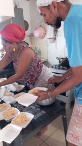
As rescue services couldn’t reach the most remoted areas, local communities organised themselves to survive and help each other. Two of our GRRIPP awardees, Cosmonucleação Regenerativa and Quilombo do Catucá, are located in some of the most affected areas of Recife and Pernambuco. While their material losses are high, they have been doing an incredible work of solidarity and support in their neighbourhoods. The leaders from the projects, mostly black and indigenous women living in the periphery, are acting as focal points and caretakers for the victims in their communities. They hosted families who had to leave their house, cooked and distributed food baskets in their area, and continue organising solidarity actions locally. Since last week, we were able to map a first list of 140 families being directly supported by our awardees in four territories.

To attend to the needs of the most vulnerable, they are organising a fundraising. The money will enable them to provide basic food baskets and hygiene material, as well as buying blankets and clothe for those who lost their homes. We are sharing here their initiative, and calling on your generosity to support their campaign and contribute to their emergency fund.

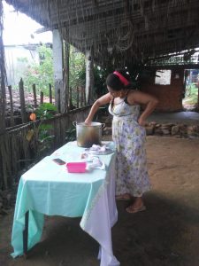
Solidarity actions in Zona da Mata Norte 


Credits to: Marília Nepomuceno

Solidarity Actions in Quilombo do Catucá


Credits to: Louisa Acciari and Moabia dos Anjos 

To contact them directly:

smariliapinheiro@gmail.com

elainemsalbuquerque@gmail.com

chadeterra@gmail.com

In solidarity with all the people of the state Pernambuco,

The GRRIPP Team

The Kedarnath Tragedy: Breakdown or Breakthrough?

By Joshua Anthony, on 1 April 2022

Author: Savin Bansal


The cataclysmic ‘Kedarnath tragedy’ of June 2013, triggered by overwhelming flash-floods and landslides in Uttarakhand, the Greater Himalayan State of India, instigated losses worth US$ 1billion, mortality at a gory high of 5000 and led to an equal number still being reported as missing. The destruction of critical infrastructure left several lakhs of pilgrims and tourists stranded for several weeks together.

The region has been long fraught with frequent, severe and uncertain onslaught of geophysical and hydrometeorological hazards, is seismically dynamic, afflicted with climatic extremes and is witness to the growing human-environment interactions. Though the moderate magnitude events probably have become a reality in the region, the 2013 hydrometeorological extreme remains unique in terms of the historic trends and exceedance probability.

The monsoon in June 2013 arrived almost two weeks earlier than expected. The torrential cloudbursts and massive Glacial Lake Outburst Floods (GLOF) resulted in a sudden swelling of the Mandakini, Alakananda, Bhagirathi and Kali river basins. Being a renowned pilgrimage and eco-tourism circuit in India, the region saw the disaster coinciding with the peak congregation, affecting more than 900,000 lives and precipitating grave infrastructure failure in just over three days. The towns of Kedarnath, Rambara and Gaurikund dotted along the Mandakini valley bore the maximum brunt.

The aftermath rendered the key public assets and critical infrastructure dysfunctional, and the exigent business processes compromised. The ravaged quintessential schools-hospitals, buckled highways and bridges, wrecked civic service delivery systems, snapped telecommunication networks, and incapacitated fire and emergency operation services only amplified the atrocious impacts. This not only compromised the relief-rescue operations but severely subdued the coping capacity of the community.

Chinks in the Armour

Many victims had misled themselves to cascading floods and landslips, several children and elderly to trauma and injuries, with others succumbing to lost will and hope. The disquieting spectacle of vanished settlements, frenzied victims and bewildered response put up a horrendous spectacle to behold. In retrospect, the delayed response and resource sub-optimization are attributed to the iniquitously deficient Risk Management framework detailed as:

Imperception of the significance the resilience holds for critical infrastructural systems:

The colossal impact was strikingly disproportionate to the infrastructure resilience levels, adaptation and coping capacities of the communities. Ironically, it took a catastrophe of such a stupendous magnitude to realise the growing reliance of society upon interconnected functional nodes and closely coupled systems. The setbacks on such systems empowered vulnerabilities to generate escalation points that spawned devastating cascades further to propagate through socio-economic systems.

Information asymmetry and risk communication deficit:

The small-scale pre-disaster (preparedness phase) knowledge sharing and generalized oblivion about risk perception and assessment among the emergency response agencies, media, volunteers, and local inhabitants denied the potential victims an opportunity to take informed decisions to protect themselves.

Inconsiderate of known-knowns:

Lack of preparedness, scenario planning, functional disaster management and resilience plans, decentralized resource inventories and inept Emergency Operation Centres accentuated the vulnerability and limited the Hazard risk-vulnerability-analysis (HRVA) capability. The underdeveloped forecasting and early warning systems subdued the evacuation mechanisms and alert protocols further.

Benighted and at odds with the idea of inter-agency coordination and collaboration:

The existence of multiple information flowlines and command structures only rendered the response entities confounded and aid agencies disoriented. It proliferated the unverifiable inputs and compromised priority sequencing. The squandering of initial golden hours of search-rescue owed itself substantially to this fallacy.

Joint Rapid Damage and Needs Assessment

The multi-sectoral damage and needs assessment carried out by the Government in collaboration with the multilateral development institutions (the World Bank and Asian Development Bank) laid the framework for stimulating major policy shift to proactive risk management besides sustainable recovery and reconstruction.

Massive investment mix in the form of IDA (International Development Assistance) and federal assistance were deployed for Risk Reduction Investments in (i) multi-hazard resilient assets such as strategic roads and bridges, public schools, and hospitals, (ii) augmenting emergency response capacities through provisioning of modern search-rescue equipment and training, (iii) bolstering hydro-meteorological network and Early Warning Systems (EWS), (iv) establishment of a risk assessment-modelling framework and a geospatial decision support system, (v) and institutionalising the Uttarakhand State Disaster Management Authority (USDMA) to operate and function in conformance with the Sendai Framework for Disaster Risk Reduction (2015-30). 

Lessons Learned

Eventually, taking the event in its stride, the State has literally risen from the ashes by drawing on the lessons learned in its wake. The pace of recovery and policy instruments deployed have been exemplary. The Risk Management framework developed is espoused as a best-practice model and now serves as a blueprint for other state entities and the neighbouring Himalayan nations.

Being at the core of economy, critical infrastructure was duly recognised as the central factor in enabling labour productivity, redistributive justice and serving our most basic needs to assuring a decent quality of life. Any disruptions therein are a drag on economies that disconcert communities through denting households’ consumption, well-being, and the productivity.

Hence, the formal mechanisms to appraise the cost-benefit ratio of ex-ante policy measures do exist now insomuch as critical asset resilience is concerned. This assumes substance in the context of minimizing the recurrent disruptive shocks on infrastructure and livelihoods, and averting the prohibitively high ex-post reconstruction cost. A pre-emptive investment in more resilient infrastructure is clearly a cost-effective and robust choice, the net result of which is a $4 in benefit for each dollar invested in resilience.

Furthermore, the policy commitments for increased resource allocation towards disaster-climate risk mitigation, reinforced multi-hazard Early Warning Systems, fully equipped District Emergency Operation centres and risk informed development planning are a reality of the day.

In addition, Incident Response System (IRS), a structured framework that enhances interoperability and behaviour coordination under multi-layered team settings is integrated well into the Emergency Response model of the State. It has proved to be critical in stimulating calibrated response to critical events all this while by bringing the disparate units together to share resources, authority and knowledge.

Conclusion

Overall, every time such low probability tail events fleet past us, they never fail to encourage adopting a paradigm shift in the ways we perceive, respond and live through the hazards. Parting ways with the reactive emergency response regime shall require mainstreaming the Disaster-Risk Reduction into development plans, policy and investments. The bottom line is that the victims endangered by life threatening exigencies don’t deserve such gratuitous procrastination and inefficiencies.


Savin Bansal is an Indian civil servant (Indian Administrative Service) and presently pursuing a Master’s degree in Risk, Disaster and Resilience at IRDR, University College London. Serving the Government of Uttarakhand, India, as an administrator and public policy practitioner, he has an extensive experience in Disaster-Climate risk management domain as a decision-maker and leading multilateral development projects.

Contribute to the discussion: savin.bansal.21@ucl.ac.uk

Disclaimer: The views and perceptions expressed are in personal capacity and can’t in anyway be construed as that of the Government of Uttarakhand, Government of India or the University College London.


 

Conflict, Disaster, and Disease: A Colossal Catastrophe Looms in the Rohingya Camps in Cox’s Bazar, Bangladesh

By Bayes Ahmed, on 20 April 2020

A panoramic view of the Kutupalong Rohingya camp in Cox’s Bazar district, Bangladesh. Source: Bayes Ahmed, fieldwork, 2019.

On 17 April 2020, another boat floating in the Bay of Bengal for two months was found carrying 30 dead bodies and 400 other Rohingya refugees, mostly women and children, fleeing armed conflict from Myanmar. Also, since 23 March 2020, the Myanmar military has been carrying out daily airstrikes and shelling in Rakhine State resulting in at least 32 civilian deaths, mostly women and children, and destroying homes and schools. The killing of innocent people and civilians by the Myanmar Army/Tatmadaw in Rakhine is still taking place fearlessly despite the International Court of Justice (ICJ), the principal judicial organ of the United Nations (UN), officially endorsed the ‘Rohingya identity’ in January 2020 and ordered the Myanmar government not to commit acts of genocide and take effective measures to prevent the destruction of any evidence related to genocide. The final verdict on the prevention and punishment of the Crime of (Rohingya) Genocide against Myanmar is pending.

The crisis is not new. The Rakhine State of Myanmar and Cox’s Bazar District of Bangladesh share international borders, and both countries were commonly ruled by the British Empire. Being the same colony for over 120 years, eventually, the Muslim Bengalis and Buddhist Rakhine people travelled between the two states (formerly known as the Arakan State) for business, agricultural and other purposes. However, since the independence of Burma in 1948, the Muslim population in Rakhine have been labelled as ‘illegal Bengali migrants’ and later on referred to as the Rohingyas. Failing to permanently expel the Rohingyas from Rakhine, the Burmese (Military) government, introduced a citizenship law in October 1982 stating that “full citizens are descendants of residents who lived in Burma prior to 1823 or were born to parents who were citizens at the time of birth”. The amended law has a clear link with the Muslim migration during the British rule in Burma between 1824-1948. Eventually, the Rohingyas lost their citizenship and became stateless.

Since then persistent torture, human rights violation and persecution followed by a number of major military crackdowns, a genocidal policy adopted by the Myanmar Army, communal violence between Muslims and Buddhists in Rakhine, and killing and murder of innocent civilians and burning down their homestead resulted in the forced displacement of Rohingyas to Bangladesh notably in 1978, 1992, 2012, 2016, 2017, and in 2019. Recently, Médecins Sans Frontières (MSF) estimated that at least 6,700 people lost their lives due to direct violence in Myanmar between 25 August and 24 September 2017. The UN estimates that over one million stateless Rohingya are still remaining in Rakhine State (600,000 displaced and 470,00 non-displaced). The actual number is unknown due to fabrication in Myanmar’s national population census and strategically replacing the names of local villages/townships. The Rohingyas are facing extreme discrimination and are being denied basic humanitarian access, livelihoods and services in Myanmar. In contrast, Bangladesh is currently hosting over 860,000 Rohingyas (78% of them are women and children) in the UN registered camps in Cox’s Bazar and over 300,00 of them are hiding as undocumented refugees. The crisis has adversely impacted more than 444,000 Bengali host community members in Cox’s Bazar.

An enormous protected area of hill forests in Cox’s Bazar district (6,000 hectares) has already been wiped out to build makeshift shelters by cutting hills and to arrange fuel for cooking for the Rohingyas. They are living in camps that are absolutely vulnerable to landslides, flash flooding, cyclones, and fire hazards. Between April to November 2019, at least 1400, 500, 70, and 35 major incidents were reported across all camps related to landslide/soil erosion, wind/storm, flood, and fire hazard respectively. As a result, over 85,000 individuals were affected and 4,000 households were displaced to another location. No effective early warning system is available for them, although the partners are consistently working to make the camps weather-proof and resilient to natural hazards.

Multi-hazard prone Rohingya makeshift camps in Cox’s Bazar district, Bangladesh. Source: Bayes Ahmed, fieldwork, 2018-2020 and Inter Sector Coordination Group (ISCG), 2019.

The Rohingyas in Cox’s Bazar are not allowed to move outside the camps and build permanent shelters. No formal education is also allowed. They depend on nominal humanitarian assistance from the UN such as basic food (rice, palm oil, and lentils). These embargos are imposed mostly to comply with the standard UN refugee mandates. The novel Coronavirus (COVID-19) pandemic is posing another major threat to the Rohingyas, as they are living in exceedingly overcrowded camps and the existing health centres are not equipped with necessary testing and treatment facilities. The same situation applies to the host communities. As instructed by the UN, the partners are advancing with the construction of an isolation and treatment centres, reducing activities to essential services and assistances only, promoting hygiene activities, training healthcare workers, and ensuring social distancing inside the camps. As of 20 April 2020, the entire Cox’s Bazar district including the camps are now locked down, and no Rohingya is even allowed to move between two camps until further notice.

Activities are undertaken to prevent COVID-19 outbreak in the Rohingya camps in Cox’s Bazar district, Bangladesh. Source: Inter Sector Coordination Group (ISCG), 2020.

The Rohingyas are also afraid to go back to Myanmar as they suspect fresh attacks on them by the Myanmar Army. The repatriation process is halted. The Rohingyas have strong community bonding and trying their best to adapt in this dreadful situation, however, all these efforts are not enough to ensure resilient futures for them. Given the international and national resolutions, the only sustainable solution for the Rohingya refugees would be to repatriate them in Myanmar with safety and dignity. 

Overall, the genocide-fled Rohingyas and already over-stressed Bangladeshi host communities in Cox’s Bazar are not ready to face the impending threats of natural hazard-induced disasters and Coronavirus pandemic. If, for example, a landslide/cyclone disaster and COVID-19 outbreak collide in the coming months, then it would be another catastrophic humanitarian crisis. The threat is inevitable, but nobody knows any decisive remedy to tackle it. Now, we can only pray for a strong cyclone or consecutive torrential rainfall events not to occur during the cyclone and monsoon season (May-November) or the Coronavirus not to spread in the Rohingya camps in Cox’s Bazar. Yet, there is no hope for their sustainable repatriation, integration, third-country settlement, or justice. The situation is somewhat true or even worse for the remaining 70 million displaced people worldwide – their sufferings have no limits!

Even a pod of whales can travel from the Indian to the Atlantic Ocean, a flock of birds can fly from one continent to the other, but unfortunately, we have created such a sickening (in)human civilisation where a group of distressed people fleeing war, conflict, climate change and natural disasters are not allowed to move freely or even claim basic human rights for their minimal level of survival. This is the bitter truth! The only long-lasting solution to this grave crisis would be to fully support global truce (including the insurgents and militias), end hatred and discrimination towards minority and refugee population, and promote peace, sustainable economic growth, and global and regional cooperation gradually.

Rohingya camps in the no man’s land in Tumbru, Naikhongchari Upazila, Bandarban district, Bangladesh. Source: Bayes Ahmed, fieldwork, 2018.

Author: Dr Bayes Ahmed, UCL IRDR

Resilient to Landslides: The Indigenous Tribal Communities of Bangladesh

By Bayes Ahmed, on 4 July 2016

Landslides are common socio-natural hazards in the Chittagong Hill Districts (CHD) of Bangladesh. Communities living in the hills of CHD can be categorized as urbanized and tribal, each community experiences a different level of risk to landslides. With this knowledge, I conducted fieldwork in the three tribal hill tracts districts (Bandarban, Khagrachari and Rangamati) in Bangladesh from November 2015 – January 2016. The primary objective of this fieldwork was to understand what makes the tribal communities resilient to landslides. The IRDR and Commonwealth Scholarship Commission funded the fieldwork. I conducted household level questionnaire surveying and community based focus-group discussions in four tribal communities in CHD. This blog is all about sharing my experience working with a remote tribal community named Sandak Para in Thanchi sub-district, Bandarban, Bangladesh.

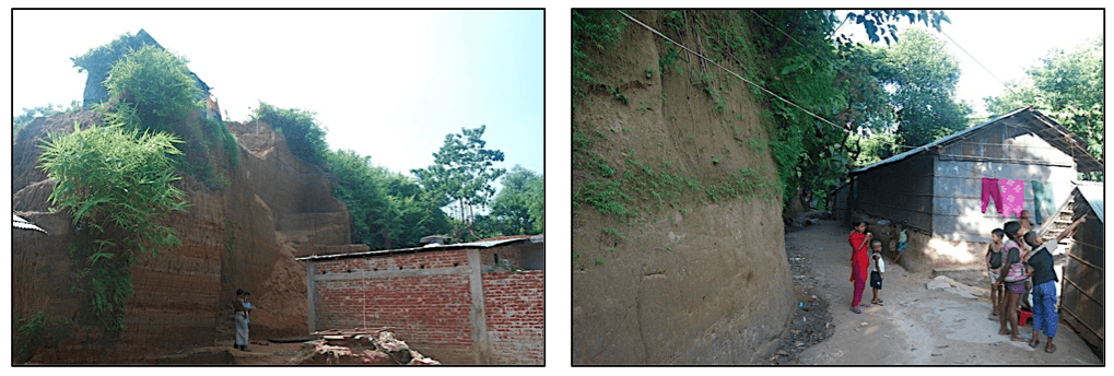
Landslides causing human casualties and massive property destruction are mainly visible within the urbanized communities in Chittagong and Cox’s Bazar. Indiscriminate hill cutting and development of unplanned settlements in the hills during the monsoon mainly cause the landslides. In contrast, the tribal people living in the remote and rural hill areas experience few or no similar landslide disasters.

Thanchi_BayesSandak Para Community in Bandarban.

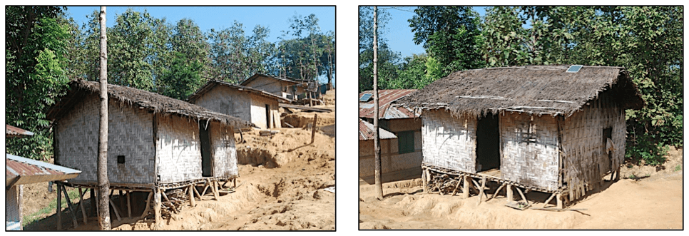
The typical tribal houses are made of locally available materials – bamboo, wood, mud and corrugated iron sheets. The foundation is laid on bamboo/tree trunks on a raised plinth from the ground and the roof is typically thatched.

Thanchi_Bayes_2Typical tribal housing – Sandak Para, Bandarban.

Tribal people have lived here permanently for few generations and no Bengali (people not living in the hills are called as Bengali/ settlers by the tribes) were found in the community. The traditional shifting cultivation (or slash and burn agriculture) is the primary occupation. There is no formal electricity supply, but people use solar power for household activities. There is no drainage network. Water supply is a major problem as people are mostly dependent on water from the Sangu River or from the nearby falls. The average monthly income of a household ranges from US$12-20 that is low earning in Bangladesh.

The architecture of the houses is helping to make the community physically less vulnerable to landslides. The raised plinth allows the rainwater to flow naturally and freely below the houses. The construction materials of the houses are lightweight and therefore not life threatening, even if the houses collapse in earthquakes or landslides. The tribal people do not cut the hills like in the urbanized areas, instead they try to build houses horizontally in the same line of hill-slopes using bamboo or tree trunks in layers. This is the indigenous knowledge applied by the tribal people to protect themselves from landslides or slope collapses.

Vulnerable Houses in CHDHouses built by cutting hills vertically in urbanized hill communities.

From initial observation, I found that the tribal communities are also addressing the different thematic dimensions of vulnerability in relation to landslides:

Economic dimension: alternative livelihood options, less damage to physical assets, and not using the hills for commercial activities.

Social dimension: no massive damage to social systems ranging from individual to collective, accessibility to necessary infrastructure and services, and social cohesion.

Cultural dimension: by treating the hills as sacred place and using centuries-old rich indigenous and local knowledge to deal with the hill environment.

Environmental dimension: protecting the hills by not destroying the hill-forests and cutting the hills in an unstable manner.

Institutional dimension: there are no power politics and few external influences; instead there is a strong local and regional network with autonomous administration.

From my fieldwork, it is evident that the indigenous tribal communities in CHD are more resilient to landslides than the urbanized settlers. It would be highly recommended to address community vulnerability by incorporating indigenous knowledge in local planning to reduce the risks of landslide disasters in the highly urbanized hill areas of Bangladesh.

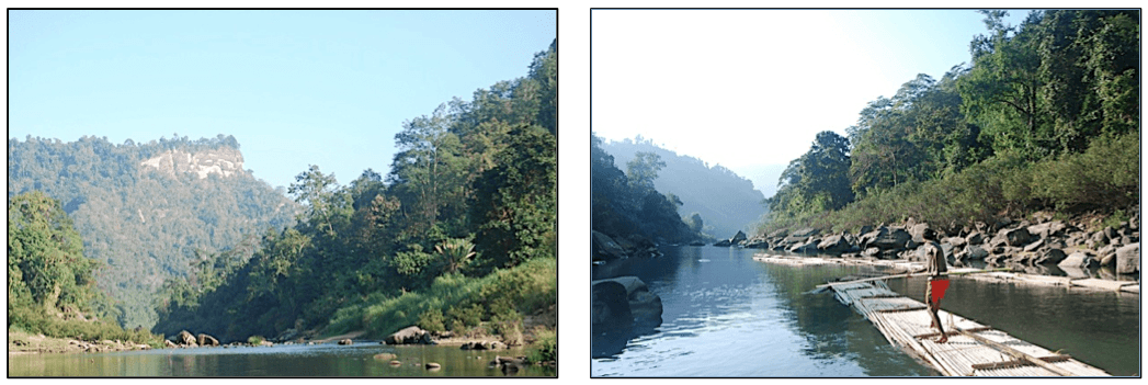
After several days of long and tiring work in the field, I took a boat ride with my field assistants; who are from the Marma tribe, in the Sangu River towards Remakri. The mesmerizing beauty of Sangu River, the surrounding green and untouched hills, the helpful tribal people, freedom from the chaotic and polluted city life and finally clean air and fresh food, all made me feel like I was in the most beautiful place on earth. I want to go back to this place again, just to enjoy the natural beauty and share some more moments with the indigenous tribal people of Bangladesh!

Bayes_4 Bayes_5Scenic beauty of Sangu River, Bandarban.

© Bayes Ahmed

Email: bayes.ahmed.13@ucl.ac.uk