X Close

Risk and Disaster Reduction Blog

Home

UCL Department of Risk and Disaster Reduction

Menu

Reflections on 2024 Noto earthquake: do we need to pay more attention to the ‘human’ element of disaster?

By Miwako Kitamura, on 3 May 2024
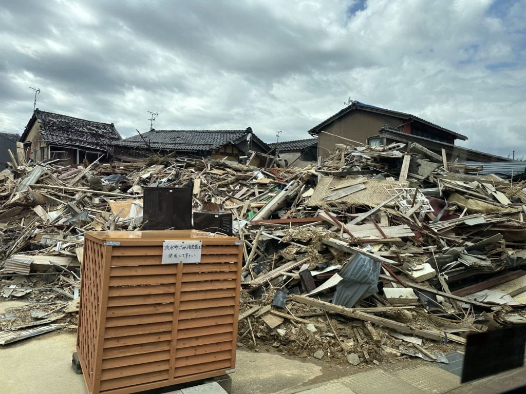
photograph of debris from a destroyed house. A surviving piece of wooden furniture stands in the foreground
Houses destroyed by the 2024 Noto earthquake in Anamizu, 16 April 2024

A 7.5 magnitude earthquake struck Noto Peninsula of Japan on New Year’s Day in 2024. Family members had come home to celebrate the New Year when the earthquake hit. Japan has a high level of awareness on disaster preparedness and mitigation. Despite this, more than 240 people lost their lives, 60,000 buildings were damaged and 25,000 people had to be evacuated from their homes. It is important to note that the deaths were caused by the earthquake where several buildings, especially the old structures collapsed. The new year’s earthquake also caused a tsunami, which arrived only a few minutes after the earthquake. However, the majority of people died from earthquakes, with only two people killed by the tsunami, which shows high awareness about tsunami preparedness among the general population, compared to the earthquakes. This shows more work needs to be done on earthquake preparedness in Japan, beyond a focus on developing and investing in resilient infrastructure.

In this short blog, we will shed some light on the experiences of people who are managing the evacuation centres, especially those evacuation centres that are led by the community. We will examine the current situation by putting gender and communities at the centre of our analysis.
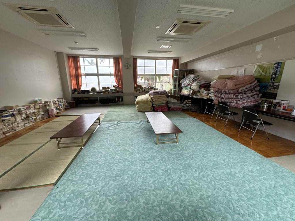
photograph of a large room with two long tables in the middle of the room. Books stacked up on the left wall. Chairs, blankets, and some kitchen equipment stacked on the right wall. Blankets stacked up against back windows too.
Community Evacuation Centre, in Sunran No Sato Kobushi. Photo taken on 16 April 2024

Although there are many government run evacuation centres, there are also several community-run evacuation centres. In Japan, community-led shelters are commonly referred to as “voluntary shelters.” Leaders of these shelters typically include local community figures and temple and shrine heads, and, as observed during the Great East Japan Earthquake, leaders of traditional performing arts groups have frequently assumed these roles. Importantly, the foremost consideration for these community-oriented shelters is their trustworthiness. What we found was that due to the gender division of labour, which is still strongly present in Japanese society, taking care of the people in the evacuation centres becomes and remains the responsibility of women, including cooking, cleaning, and caretaking roles.

One important thing to note here is that these women, often wives/daughters/daughters-in-law, of the community leaders who automatically become the caretaker of the entire community in the times of crisis, are themselves the survivors of such events. However, they need to sacrifice their own needs and look after others. With harmony being the central key in Japanese social organisation, speaking of their own needs is seen as being selfish. Hence, no one is willing to do that: they would rather suffer than to bear the consequences of social stigma. This creates an environment where these women who are responsible for running the evacuation are often double victims: victims of the disaster and also the victims of post-disaster responsibilities.  

The person responsible for one of the evacuation centres we visited said it is comparatively manageable soon after the disaster as we only need to manage their immediate needs and there are more volunteers. However, as the time passes, people would like their normal life to return, which means a need for proper meals, proper sanitation, healthcare services, better accommodation and so on. The volunteers often go back to everyday life and the support from the government often dries out in about three months but the needs of those who are left behind – still in evacuation centres for various reasons – remain or they need even further support. Hence, taking care of the evacuees becomes a bigger responsibility, which needs to be factored into the discussions around disaster mitigation.

As evidenced during fieldwork and engagement activities in the communities affected by the earthquake in Noto, there are key local contexts and practices which must be appreciated and factored into future preparedness and response activities for disaster risk reduction. Discussions with stakeholders and local leaders for example highlighted the central value of community involvement in shaping and informing responses to disasters.

Photograph of rubble from a destroyed building.
Houses destroyed by the 2024 Noto earthquake in Anamizu, 16 April 2024

While it was reported that affected communities following the earthquake were more reserved in their engagement with the national government, they engaged readily and openly when responses were designed and driven by local communities, as evidenced by the creation of these community evacuation centres. These observations on the need to centre community involvement in disaster risk reduction and response are further substantiated by existing evidence from another disaster case study in Japan— the 2011 Tōhoku earthquake and tsunami which underscored a similar significance regarding the importance of contextually-appropriate and community-supported activities for disaster risk reduction and preparedness and response to events including earthquakes and tsunamis in regionally and geographically diverse countries, like Japan.

Our visit to the Noto Peninsula also revealed important observations and considerations on local understandings of leadership in disaster contexts, and how entrenched and gendered understandings of what constitute leadership can serve as a barrier to further vital involvement and participation of communities during events like earthquakes.  This was made apparent during discussions with female local leaders in Noto who had noted and reflected on how, despite their extensive involvement in disaster response and support activities, they did not consider themselves to be ‘leaders’ in these disaster contexts. Instead, many of their channels of leadership and support, including organising community efforts, food provision and emotional support had been regarded as traditionally ‘female’ associated practices and expectations rather than leadership roles during emergencies like earthquakes.

Again, this underscores the need to integrate local thinking and contexts in working to improve and promote local leadership during disasters in Japan by including gender frameworks to uncover how existing power dynamics and divisions of labour produce inequitable understandings of leadership, and where possible and when contextually-appropriate, to engage and work with these local communities to promote and centre diverse profiles and practices of disaster leadership and engagement of women and gender-diverse communities.

Our observations from these fieldwork activities investigating gender and women’s leadership in the Noto Peninsula also hold broader importance for the fields of disaster risk reduction and global health beyond preparing for and responding to earthquakes. Japan continues to be vulnerable to a broad scope of public health risks including earthquakes, tsunamis, volcanic activity, floods, typhoons and the climate change emergency. Despite ongoing disaster and resilience planning, there remains a critical need for the ongoing consideration and integration of gender-focused and community-centred participation and leadership activities as revealed during these fieldwork engagements to ensure that future responses and recovery to these events are both sustainable and equitable. 


Co-authors

Dr Miwako Kitamura is an Assistant Professor at the International Research Institute of Disaster Science at Tohoku University

Dr Anawat Suppasri is an Associate Professor at the International Research Institute of Disaster Science at Tohoku University

Ms Hayley Leggett is a PhD candidate at the School of Engineering at Tohoku University

Dr Anna Matsukawa is an Associate Professor at University of Hyogo

Dr Stephen Roberts is Lecturer in Global Health at the Institute for Global Health at University College London

Dr Punam Yadav is an Associate Professor at the Institute for Risk and Disaster Reduction at University College London


The views expressed in this blog are those of the author(s).

Read more IRDR Blogs

Follow IRDR on Twitter @UCLIRDR

Using Fault data in seismic hazard and risk assessment: A fault2SHA initiative

By Joanna P Faure Walker, on 22 March 2021

Effective fault data presentation helps make progress in the calculation of earthquake hazard and risk. 

Cross-disciplinary working can help progress. For calculating seismic hazard, the Fault2SHA Working Group has brought together data providers, modellers and seismic hazard and risk practitioners to help promote the use of fault data in seismic hazard assessment… Fault2SHA representing fault – to – seismic hazard assessment.

In the case of earthquake hazard and risk calculations, a key barrier to fault-based seismic hazard assessment has been the availability of data in a format that can be easily incorporated into calculations of hazard and risk. This has hindered efforts to provide long-term views of hazard and risk. Long-term, multi-millennia time frames cover several seismic cycles such that the long-term behaviour of faults can be identified and not miss out faults capable of hosting earthquakes which have not ruptured within a short-term observation periods (tens or hundreds of years). A further restriction has been the difficulty for modellers to interrogate the detail and uncertainties in primary data. To address these issues, the Fault2SHA Central Apennines laboratory, led by Dr Joanna Faure Walker (UCL IRDR), has created a database structure demonstrating a usable format by which geologists can present data that can be directly incorporated into hazard and risk calculations. To demonstrate its effectiveness, the laboratory has tested the database to calculate simplified calculations of risk in the Central Apennines and demonstrated the effectiveness, even at a simple level, for identifying which faults threaten the public the most and where additional data would have the most impact on current calculations. It is hoped those working in other regions can help the endeavour of promoting the use of faults in seismic hazard assessment through adopting a similar approach.

This work brings together researchers from different research groups in the UK, Italy and France: Joanna Faure Walker, Paolo Boncio, Bruno Pace, Gerald Roberts, Lucilla Benedetti, Oona Scotti, Francesco Visini, and Laura Peruzza

The two papers are published Scientific Data and Frontiers in Earth Science, while the database is available through PANGAEA.

Fault2SHA Central Apennines Database and structuring active fault data for seismic hazard assessment 

Which Fault Threatens Me Most? Bridging the Gap Between Geologic Data-Providers and Seismic Risk Practitioners

Fault2SHA Central Apennines Database

The Fault2SHA working group runs a monthly online learning series to help cross-disciplinary working and annual workshops.  The learning series and 2020 workshop is available through the Fault2SHA youtube channel. A summary of the database is provided by Joanna at 17 mins into the first session of the Fault2SHA 5th workshop:Promoting Faults in Seismic Hazard Assessment


A step closer in earthquake forecasting

By Joanna P Faure Walker, on 16 August 2019

Dr Zoe Mildon, former IRDR PhD student and now lecturer at University of Plymouth, together with Dr Joanna Faure Walker  (UCL IRDR), Prof Gerald Roberts (Birkbeck) and Prof Shinji Toda (Tohoku University IRIDeS), have published a paper in Nature Communications showing we are a step closer in understanding which faults could rupture in the next earthquake:

Coulomb pre-stress and fault bends are ignored yet vital factors for earthquake triggering and hazard

In this paper, we use long-term stress loading on faults in the central Apennines, Italy, together with stress loading from historical earthquakes in the region to test whether we can identify faults which have a positive stress and hence are ripe for rupture.  We found that 97% large earthquakes within the central Italian Apennines from 1703-2006 occurred on positively stressed faults. Therefore, we can use our modelling to calculate which faults are currently positively stressed and hence help us to determine which faults could rupture in the future. This is not the same as earthquake prediction – saying exactly when and where an earthquake will occur, but it is a step closer to better seismic hazard assessments and understanding why, how and when earthquakes occur.

Dr Joanna Faure Walker standing by a limestone fault scarp in the central Italian Apennines

The paper is available through open access: Mildon et al. (2019)

An article was written about the paper in the Daily Mail

The original press release is available here.

This work is part of the IRDR’s continuing collaboration with Tohoku University, IRIDeS (International Research Institute for Disaster Science). Our collaboration has led to papers including topics such as earthquake stress transfer (Mildon et al., 2016), disaster fatalities (Suppasri et al., 2016), and temporary housing (e.g. Naylor et al., 2018).

New paper on segmented normal fault systems

By Joanna P Faure Walker, on 19 June 2019

Publication of: Occurrence of partial and total coseismic ruptures of segmented normal fault systems: Insights from the Central Apennines, Italy by Iezzi et al. (2019)

Francesco Iezzi (PhD student, Birkbeck) together with Prof Gerald Roberts (Birkbeck), Dr Joanna Faure Walker (IRDR) and Ioannis Papanikolaou (Agricultural University of Athens) have published a detailed study of the long-term displacements across the fault responsible for the 2009 L’Aquila Earthquake, Italy, and the surrounding faults. This reveals that the different faults are behaving together so that the displacement across the system of faults looks similar to if it were one larger fault on ten thousand and million year timescales. This finding can help provide clues regarding the relative local seismic hazard between the different fault segments. The study also provides evidence that the vertical displacement (throw) across a fault increases across fault bends, a result that has been demonstrated in previous papers by the research group (e.g. Faure Walker et al., 2009; Wilkinson et al., 2015, Iezzi et al., 2018). The Iezzi et al. (2019) paper discusses the synchronised and geometrically controlled activity rates on the studied faults in terms of the propensity for floating earthquakes, multi-fault earthquakes, and seismic hazard.


Photograph of damage following the 2009 L’Aquila earthquake, taken by Joanna Faure Walker while accompanying the EEFIT mission.

More data needed for better earthquake hazard and risk calculations

By Joanna P Faure Walker, on 6 November 2018

New research demonstrates the importance of having detailed measurements at multiple sites along a fault of how fast the fault is moving and how the surface orientation of the fault changes. To access the full paper click here.

Why do we need fault measurements?

Measurements of fault slip rate and the geometry of the fault (it’s 3d orientation) can be used to calculate earthquake recurrence intervals to give probabilities of how likely earthquakes of different magnitudes are to occur. We also need these measurements to model how much ground shaking there will be at given locations. Hazard maps of expected ground shaking can be used to inform building codes and identify where buildings including homes and schools might need retrofitting to improve their resistance to earthquake shaking.

There are other methods available for creating earthquake hazard maps, such as using historical records of earthquake shaking. However, these records unlikely go back far enough in time to capture all faults capable of hosting large earthquakes because some faults will not have hosted earthquake within the time period covered by such records. Therefore, the hazard from some faults would be missing in hazard maps based solely on historical seismicity leading to underestimations in earthquake hazard.

What new insights have been revealed in the research publication?

The paper, entitled “Variable fault geometry suggests detailed fault slip rate profiles and geometries are needed for fault-based probabilistic seismic hazard assessment (PSHA)” demonstrates that relying on only one or a few measurements of how fast the fault is moving along a fault and projecting these measurements along the entire fault may lead to underestimating the uncertainty in the earthquake hazard calculations. Crucially, there may be locations where the hazard is underestimated, meaning people could be at more risk than suggested by simpler models (the converse is also possible). Therefore, earthquake hazard assessments based on fault parameters need to either use detailed measurements including measurements of how fast the fault is moving at multiple sites along the fault or to incorporate how the lack of such data increases the uncertainty in calculated earthquake hazard assessments.

Why are detailed measurements not being already used?

In many regions it is difficult to constrain the fault slip rate (how much the fault has moved in a given time) or throw rate (vertical component of slip rate) along a fault at even one location, let alone several. However, there are regions where this is possible so as more data is collected, this detail should help to improve earthquake hazard assessments both in those regions and worldwide.

Where can I find out more?

Faure Walker J., Visini F., Roberts G., Galasso C., McCaffrey K., and Mildon Z., (2018) Variable fault geometry suggests detailed fault slip rate profiles and geometries are needed for fault-based probabilistic seismic hazard assessment (PSHA), Bulletin of the Seismological Society of America, doi: 10.1785/0120180137

The Fault2SHA Working Group is an ESC (European Seismological Commission) group of researchers in both universities and civil protection authorities collaborating to increase incorporation of fault data in seismic hazard assessments and to improve our understanding of how such data should be used.

Fault2SHA has successful session at ESC 2018 in Malta

By Joanna P Faure Walker, on 7 September 2018

The Fault2SHA ESC (European Seismological Commission) Working Group hosted a session on Wednesday 5th September at the ESC 2018 Meeting held in Valletta, Malta. Oona Scotti represented the group in her keynote on the opening day of the conference, in which she addressed “Modelling fault systems in PSHA: Challenges Ahead”. The Fault2SHA Working Group, for which I am on the Executive Committee, links different researchers working on faults and seismic hazard assessment (SHA) in Europe and beyond. This collaboration has brought together field geologists, fault-modellers and probabilistic seismic hazard modellers. The group provides a forum in which data, results, modelling capabilities, and improvements in scientific understanding can be shared. If you want more information, and to join, see Fault2SHA. The next Fault2SHA workshop will be in Kaust, Saudi Arabia, in November 2018 and the next meeting will run on 3rd-5th June 2019 in Barcelona, Spain.

I lead the Fault2SHA Central Apennines Laboratory. Our team comprises researchers from Italy (Paolo Boncio, Bruno Pace, Laura Peruzza, Francesco Visini), France (Lucilla Benedetti, Ooona Scotti) and the UK (Joanna Faure Walker, Gerald Roberts). At ESC in Malta, I introduced the central Apennines Laboratory and our current activities to the wider working group. The Central Apennines, as well as being a beautiful place to conduct fieldwork with the opportunity to obtain detailed datasets, suffers from large magnitude earthquakes. Indeed, earthquakes in the Central Apennines have featured widely in the UK press due hosting the two deadliest earthquakes in Europe of the last ten years: the 2009 L’Aquila sequence and the 2016 Amatrice-Norcia sequence.


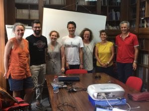
The Fault2SHA Central Apennines Laboratory, which formed in January 2018, held an in-person meeting in July at the University of Chieti-Pescara, Italy. The photograph shows (from left to right) Oona Scotti, Francesco Visini, Joanna Faure Walker, Bruno Pace, Laura Peruzzi, Lucilla Benedetti, and Paolo Boncio.

During the Fault2SHA ESC session, I presented a second talk and a poster about my research investigating the importance of incorporating detailed fault geometry for understanding seismic hazard. The oral presentation demonstrated the importance of incorporating detailed fault geometry and loading on faults between earthquakes in Coulomb Stress Transfer modelling, a process that causes the stress on faults to change in response to an earthquake on a neighbouring fault. This was based on work carried out by Zoe Mildon (former IRDR PhD student, now a lecturer at the University of Plymouth) in collaboration with Gerald Roberts, Shinji Toda and myself (see Midon et al. 2016 and Mildon et al. submitted preprint). The poster displayed the importance of detailed fault geometry and slip-rate data for calculating earthquake probabilities and ground shaking intensities. I further represented Zoe for her poster within the session on earthquakes in regions of distributed deformation, that showed surface ruptures from the 1997 Colfiorito Earthquake in the central Apennines was due to primary earthquake slip (see Mildon et al., 2016 for details).

I thank all those at the conference with whom I had interesting discussions and I look forward to seeing all of our research progress.

Roots of earthquake-prone faults brought to light

By Joanna P Faure Walker, on 25 November 2013

Earthquakes affect many highly populated areas around the world so understanding what controls the distribution and frequency of them is a top priority for the earth science and disaster risk reduction communities. Often, however, the controlling factors remain elusive because scientists have limited information about what happens deep down in the Earth’s crust where earthquakes initiate. A recent Nature Geoscience article (Cowie et al. (2013) published online on 3rd November, 2013) has shed light on the problem, and has shown how phenomena on the surface can be linked to the movement of rocks in the deep crust.

(more…)

Fieldwork in Abruzzo: Four years on from L’Aquila

By Luke N J Wedmore, on 19 April 2013

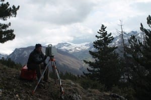
With the 4-year anniversary of the devastating L’Aquila earthquake occurring in the middle of my first PhD fieldtrip to Italy, the importance of studying active faults in the Abruzzo region remained at the front of my thoughts throughout my trip. The aim of the trip was to use Laser scanning (LiDAR) and ground penetrating radar (GPR) to increase our understanding of the active earthquake faults in the area. The group comprised Dr. Joanna Faure Walker (UCL IRDR), Dr. Ken McCaffrey (Durham University) and Dr. Laura Gregory (University of Leeds).

Dr. Ken McCaffrey (Durham University) using LiDAR to scan active normal faults in Abruzzo

Dr. Ken McCaffrey (Durham University) using LiDAR to scan active normal faults in Abruzzo

The first week was spent collecting GPR and LiDAR data along active faults, while the second week was spent hunting for potential future data collection sites. The active normal faults in this area can be seen in the landscape due to the existence of prominent limestone bedrock fault scarps on the side of steep mountains. However, such fault scarps are not present everywhere; for example, part of the fault responsible for the 1915 Avezzano earthquake that killed over 30,000 people crosses the Fucino plain. The Fucino basin is a former lake bed that was drained in the 1800’s. Consequently, the fault scarp has been obscured by erosion from the lake and more recently by intensive farming. LiDAR scans of sites along the fault trace within the plain ensure that we have a 3D digital image of the current state of the fault.

LiDAR scanning on the Fucino Plain

During the course of the two-week trip I visited 10 active faults across the region of Abruzzo and collected large quantities of data to process over the coming months. Visiting the faults for the first time was invaluable to my understanding of the earthquake hazard and overall seismic risk that people in the area are subject to.  Observing spectacular villages that cling to the sides of mountains located in the hanging walls of active faults and larger towns in the basins below highlighted the potentially devastating impact earthquakes in the area could have.  The results of my work will feed into a larger NERC funded study which aims to determine the time since each active fault last produced an earthquake; being a first year PhD student, this is a fantastic opportunity for me and I am looking forward to contributing to such an innovative and exciting project.