X Close

Risk and Disaster Reduction Blog

Home

UCL Department of Risk and Disaster Reduction

Menu

Mapping the world’s largest hidden resource

By Mohammad Shamsudduha, on 15 February 2024
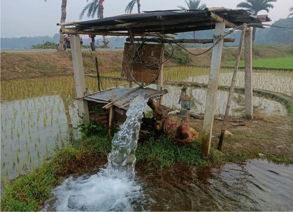
photograph of a water pump in wet agricultural land
Groundwater-fed irrigation in southwest Bangladesh (credit: Ahmed Rahman, UCL IRDR)

Water sustains life and livelihoods. It is intrinsically linked to all aspects of life from maintaining a healthy life, growing food, and economic development to supporting ecosystems services and biodiversity. Groundwater—water that is found underneath the earth’s surface in cracks and pores of sediments and rocks—stores almost 99% of all liquid freshwater on Earth. Globally, it is a vital resource that provides drinking water to billions of individuals and supplies nearly half of all freshwaters used for irrigation to produce crops. But are we using it sustainably?

Abstraction


Groundwater is dug out of subsurface aquifers by wells and boreholes, or it comes out naturally through cracks of rocks via springs. Today, about 2.5 billion people depend on groundwater to satisfy their drinking water needs, and a third of the world’s irrigation water supply comes from groundwater. It plays a crucial role in supplying drinking water during disasters such as floods and droughts when surface water is too polluted or absent. Despite its important role in our society, the hidden nature of groundwater often means it is underappreciated and underrepresented in our global and national policies as well as public awareness. Consequently, A hidden natural resource that is out of sight is also out of mind.

Some countries (e.g., Bangladesh) are primarily dependent on groundwater for everything they do from crop production to the generation of energy. Other countries like the UK use surface water alongside groundwater to meet their daily water needs; some countries (e.g., Qatar, Malta) in the world are almost entirely dependent on groundwater resources. Because of its general purity, groundwater is also heavily used in the industrial sector.

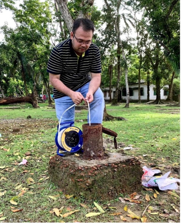
photograph of man taking measurements at a borehole
Measuring groundwater levels in a borehole in Bangladesh by IRDR PhD student Md Izazul Haq

Monitoring


Despite our heavy reliance on it, there is a lack of groundwater monitoring across the world. Monitoring of groundwater resources, both quality and quantity, is patchy and uneven. Developed countries like Australia, France and USA have very good infrastructure for monitoring groundwater. Monitoring is little or absent in many low- and medium-income countries around the world. There are some exceptions as some countries in the global south such as Bangladesh, India and Iran do have good monitoring networks of groundwater levels.

Groundwater storage changes are normally measured at an observation borehole or well manually with a whistle attached to a measuring tape, so when it comes into contact with water, it makes a sound. It can be also monitored by sophisticated automated data loggers. Groundwater can be monitored indirectly using computer models and, remotely at large spatial scales, by earth observation satellites such as the Gravity Recovery and Climate Experiment (GRACE) twin satellite mission. Models and satellite data have shown that groundwater levels are falling in many aquifers around the world because of over-abstraction and changes in land-use and climate change. However, due to lack of global-scale monitoring of groundwater levels, mapping of world’s aquifers has not been done at the scale of its use and management.

Current research


New research published in Nature (Rapid groundwater decline and some cases of recovery in aquifers globally) led by researchers from UCL, University of California at Santa Barbara and ETH Zürich has analysed groundwater-level measurements taken over the last two decades from 170,000 wells in about 1,700 aquifer systems. This is the first study that has mapped trends in groundwater levels using ground-based data at the global scale in such an unprecedented detail that no computer models or satellite missions have achieved this so far. The mapping of aquifers in more than 40 countries has revealed great details of the spatiotemporal dynamics in groundwater storage change.

The study has found that groundwater levels are declining by more than 10 cm per year in 36% of the monitored aquifer systems. It has also reported rapid declines of more than 50 cm per year in 12% of the aquifer systems with the most severe declines observed in cultivated lands in dry climates. Many aquifers in Iran, Chile, Mexico, and the USA are declining rapidly in the 21st century. Sustained groundwater depletion can cause seawater intrusion in coastal areas, land subsidence, streamflow depletion and wells running dry when pumping of groundwater is high and the natural rates of aquifer’s replenishment are smaller than the withdrawals rates of water. Depletion of aquifers can seriously affect water and food security, and natural functioning of wetlands and rivers, and more critically, access to clean and convenient freshwater for all.

The study has also shown that groundwater levels have recovered or been recovering in some previously depleted aquifers around the world. For example, aquifers in Spain, Thailand as well as in some parts of the USA have recovered from being depleted over a period of time. These finding are new and can shed light on the scale of groundwater depletion problem that was not possible to visualise from global-scale computer models or satellites. This research highlights some cases of recovery where groundwater-level declines were reversed by interventions such as policy changes, inter-basin water transfers or nature-based but technologically-aided solutions such as managed aquifer recharge. For example, Bangkok in Thailand saw a reversal of groundwater-level decline from the 1980s and 1990s following the implementation of regulations designed to reduce groundwater pumping in the recent decades.

Groundwater is considered to be more resilient to climate change compared to surface water. Experts say climate adaptation means better water management. Globally, the awareness of groundwater is growing very fast. It has been especially highlighted in the latest IPCC Sixth Assessment Report, the UN World Water Development Report 2022 (Groundwater: Making the invisible visible), the UN Water Conference 2023, and more recently in COP28 (Drive Water Up the Agenda). Groundwater should be prioritised in climate and natural hazard and disaster risk reduction strategies, short-term humanitarian crisis response and long-term sustainable development action.

Read the full nature article.


Dr Mohammad Shamsudduha “Shams” is an Associate Professor in IRDR with a research focus on water risks to public health, sustainable development, and climate resilience.


The views expressed in this blog are those of the author.

Read more IRDR Blogs

Follow IRDR on Twitter @UCLIRDR

The Search for a Natural River

By Joshua Anthony, on 27 January 2023

Following the UK’s exit from the European Union, the legacy leftover from the EU’s Water Framework and Flood Directives, which jointly encourage sustainable management of flood risk, lives on. The UK has seen a number of similar national policy frameworks implemented aiming to reduce flood risk while improving water quality and biodiversity, with over 100 river restoration projects seen in London alone between 2000 and 2019. Most of these efforts are geared towards sustainability in the face of climate change, but, with regards to the long-term, the river itself is often left out of the plans.

The historic human efforts to manage rivers have been progressively called into question over their sustained maintenance costs and an incongruity with environmental and ecological health. An alternative solution is to renaturalise and restore natural processes—reconnecting rivers with their floodplains, reintroducing wild species, run-off targeted tree planting—but this would also be to submit to a changing and dynamic landscape. Rivers can change course—sometimes very suddenly—or silt-up and become unnavigable. True sustainability should therefore account for the long term changes of rivers, but these changes are rarely accounted for in flood risk management policy. As Andrew Revkin asks: “sustain what?”

The problem with “natural”

The problem is partially semantical. The terms renaturalisation, restoration, and rewilding carry with them the image of an implied prior state or a “Lost Paradise”. Ironically, it is precisely the long legacy of human engineering, which some modern schemes are trying to reverse, that denies us the knowledge of a natural state; it is difficult to look into the past, when the waters are so muddied by our imprint. As a result, our ability to assess the future impact of renaturalisation is equally hindered. 

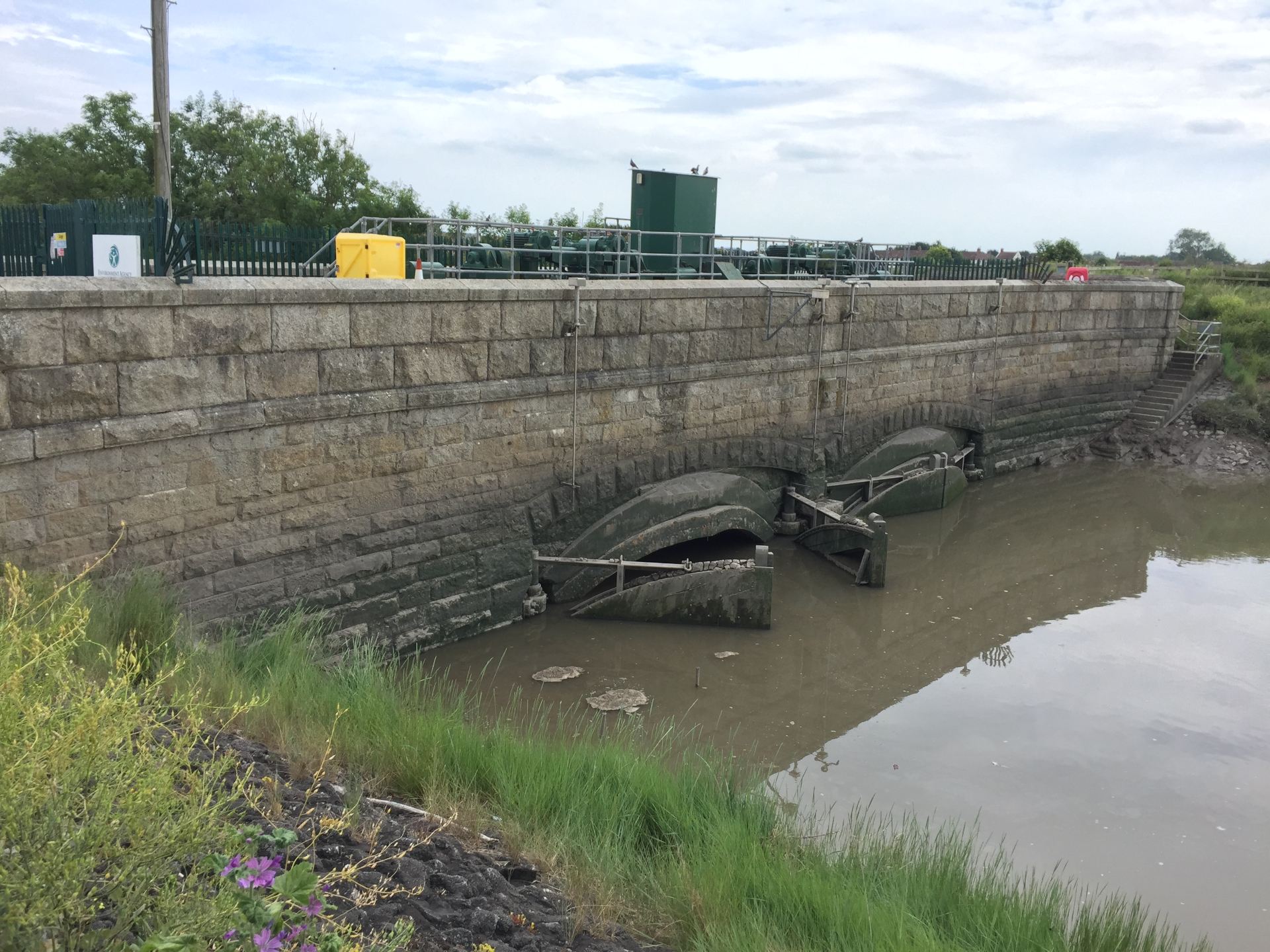
Arguably nowhere in the UK is this problem illustrated better than in the Somerset Levels, which as far back as the roman occupation of Britain has seen artificial drainage and reclamation in order to take advantage of its pastoral and arable potential. At present, the flat, largely reclaimed floodplain relies heavily on a vast network of excavated drainage ditches (rhynes in the local vernacular), sluice gates (clyces), and pumping stations that push the water through the highly banked and augmented river channels; a £100 million tidal barrier has just been approved on the River Parrett, while existing rivers continue to be enlarged to carry extra flood water. Clearly, it is hard to imagine what natural means in this context.

A clyce (sluice gate) in Highbridge that stops in the inflow of tidal water.

Seeing Into the Past

Fortunately, remnants of abandoned rivers—palaeochannels—that have long since stopped flowing through the Levels litter its landscape and offer a glimpse into the past. There are numerous examples of such ancient rivers still visible on the Somerset landscape today, which often surface during high flood stages, but are now easily identifiable with the advent of Light Detection and Ranging (LiDAR) technology, which provides high-resolution elevation data. Palaeochannels have been of interest to researchers in this area because they reveal historic drainage patterns, showing in which direction rivers used to flow before being redirected or abandoned long ago.

Where archaeological records are unavailable—often early in or before human occupation—the reasons for change are less clear. Were the causes human made, or related to a historical climatic shift? And could this inform the way we plan rivers today? To find out more, it is necessary to dig deeper into the landscape. 

The Somerset Levels have experienced their own fair share of devastating floods and are intensely embroiled in the debate between hard engineering measures and natural flood management, which has previously culminated in fierce criticism of the Environment Agency for not carrying out regular dredging. This image reveals an ancient river channel emerging from the flood waters of 2013/2014 around Burrowbridge, Somerset.

Seeing Beneath the Surface

Beneath the sediment that buries them are rivers preserved from a past time. Within the sediment is contained information from the processes and conditions that presided over the river’s eventual abandonment. Here we can see the geometry of the river and look for signs of erosion and migration, and indicators for the causes of abandonment.

A seismic refraction survey conducted in the Somerset Levels.

To overcome the logical problem of seeing buried features, geophysical methods offer a quick and non-invasive way of imaging the subsurface. By applying a force to the ground and measuring a response from beneath, a model of the rivers can be produced. These methods have been tested extensively by scientists for many years in a variety of environments, including floodplain sediments, and are in the UK probably most famously associated with Time Team’s “geofizz”, due to their strong archaeological applications. 

This research uses a combination of electrical resistivity, seismic refraction, and ground penetrating radar methods to image the buried cross-section of ancient rivers. In this way, the river acts as an archaeological feature for investigating the past, and is hoped to provide reference states for river systems that have existed prior to and throughout different periods of human occupation. Surveys have been completed on two sites on either side of the River Parrett, clearly showing the extent of the historical river systems. More are to follow at different sites across the Somerset Levels. 

Imagery of a buried channel as depicted by measurements of resistivity to an electrical current.

Glimpsing into the past of ancient river systems could help in planning for the future development of renaturalised rivers, by exploring scenarios where the measures that humans (and rivers) have grown accustomed to are absent. It may be that, like a river, management plans must be dynamic and adaptable to natural change; otherwise, a one-size-fits-all approach to sustainability is bound to become unsustainable.


To find out more about this project, email me at joshua.anthony.19@ucl.ac.uk

Josh Anthony is a PhD Candidate at IRDR and Editor of the IRDR blog.