X Close

Risk and Disaster Reduction Blog

Home

UCL Department of Risk and Disaster Reduction

Menu

Archive for the 'IRDR funded travel and projects' Category

IRDR Masters student publishes Early Warning and Temporary Housing Research. This is part of the on-going collaboration between UCL-IRDR and IRIDeS-Tohoku University

By Joanna P Faure Walker, on 4 June 2018

Angus Naylor, an IRDR Masters student alumni and Masters Prize Winner, has published the research conducted for his Independent Research Project. The research was carried out as part of his MSc Risk, Disaster and Resilience with me, his project supervisor, and our collaborator at Tohoku University IRIDeS (International Research Institute of Disaster Science), Dr Anawat Suppasri.

Following the Great East Japan Earthquake and Tsunami in 2011, UCL-IRDR and Tohoku University IRIDeS wanted to join forces to learn more about both the fundamental science and impacts of disasters both in Japan and around the world. Naylor’s recently published paper adds to other collaborative outputs from the two institutes: Mildon et al., 2016, investigating Coulomb Stress Transfer within the area of earthquake hazard research; Suppasri et al., 2016 investigating fatality ratios following the 2011 Great East Japan Tsunami; and IRDR Special Report 2014-01 on the destruction from Typhoon Yolanda in the Philippines. The two institutions have met on a number of occasions, and have an upcoming symposium in October 2018.

In 2014, three and half years after the Great East Japan Earthquake and Tsunami destroyed much of Tohoku’s coastline, I led and Dr Anawat Suppasri organised a joint UCL-IRDR and Tohoku University IRIDeS team, visiting residents of six temporary housing complexes in Miyagi and Iwate prefectures. While there, we used written questionnaires and informal group interviews to investigate the suitability of early warning systems and the temporary housing among the elderly population affected by this event.

When analysing the results, we found overall that age was not the principal factor in affecting whether a warning was received, but did play a significant role regarding what was known before the warning was received, whether action was taken and how temporary and permanent housing was viewed. The results suggest that although the majority of respondents received some form of warning (81%), no one method of warning reached more than 45% of them, demonstrating the need for multiple forms of early warning system alerts. Furthermore, only half the respondents had prior knowledge of evacuation plans with few attending evacuation drills and there was a general lack of knowledge regarding shelter plans following a disaster. Regarding shelter, it seems that the “lessons learned” from the 1995 Kobe Earthquake were perhaps not so learnt, but rather many of the concerns raised among the elderly in temporary housing echoed the complaints from 16 years earlier: solitary living, too small, not enough heating or sound insulation and a lack of privacy.
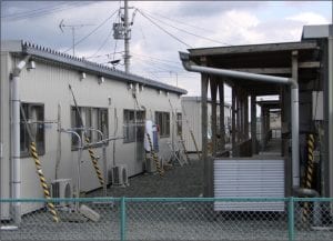
An example of Temporary Housing following the Great East Japan Earthquake and Tsunami visited during the fieldwork for this study (Photograph: Dr Joanna Faure Walker)

The research supports previous assertions that disasters can increase the relative vulnerabilities of those already amongst the most vulnerable in society. This highlights that in order to increase resilience against future disasters, we need to consider the elderly and other vulnerable groups within the entire Early Warning System process from education to evacuation and for temporary housing in the transitional phase of recovery.

The paper, ‘Suitability of the early warning systems and temporary housing for the elderly population in the immediacy and transitional recovery phase of the 2011 Great East Japan Earthquake and Tsunami’ published in the International Journal of Disaster Risk Reduction, can be accessed for free until 26th July here, after this date please click here for standard access.

The authors are grateful for the fieldwork funds which came from The Great British Sasakawa Foundation funding to UCL-IRDR and MEXT’s funding to IRIDeS. The joint UCL-IRDR1 and IRIDeS2 fieldwork team comprised Joanna Faure Walker1, Anawat Suppasri2, David Alexander1, Sebastian Penmellen Boret2, Peter Sammonds1, Rosanna Smith1, and Carine Yi2.

Angus Naylor is currently doing a PhD at Leeds University
Dr Joanna Faure Walker is a Senior Lecturer at UCL IRDR
Dr Anawat Suppasri is an Associate Professor at IRIDeS-Tohoku University

Research Update: Localising Emergency Management in Nigeria

By Rebekah Yore, on 7 November 2017

Article by Emmanuel Agbo

The recent devastating effects of natural hazards globally, such as hurricanes, floods, earthquakes, erosion, tsunamis, and landslides, in spite of the many predictive, defensive and reduction measures, call for great concern. Though this situation is often largely attributable to climate change, population growth and urbanisation, its catastrophic effect to humans and the environment, shows to a greater extend the limitations of science and technology and the many disasters risk reduction measures in disaster management. It also highlights a potential need for more proactive measures towards disaster risk reduction.

6d28a69f5c648644e434b02cf9824450Nonetheless, government commitment and willingness to undertake disaster risk reduction measures proves to be a veritable tool for effectiveness in disaster management. While the viability of this tool is undoubtably clear, its implementation often becomes distorted in most developing nations. This is so, as the shared responsibility between the state, the federal and the local government, in a top-down disaster operational approach as practice by most developed economies and adopted by many developing nations, suffers lots of implementation flaws. This occurs frequently within federated nations, where each government level is viewed as a sovereign state. This approach of emergency management places the civil protection measures at the mercy of politicians, who often prefer the provision of relief material to disaster victims in a bid to secure cheap political points rather than engaging in activities that will better prepare the vulnerable towards disaster incidents.

Nigeria-1

In recognition of these challenges, and in the quest to better prepare for disasters, my research supposes that locally institutionalising an emergency management culture within developing nations, serves to quell inconsistencies in its emergency operational framework. As all disasters, regardless of scale, happen first in communities, the local people are always the first to address its occurrences. To achieve greater preparedness, the level of information and awareness of hazards, as well as the potential mitigation strategies at the local level, needs be enhanced. To this end my research, through the Institute for Risk and Disaster Reduction research fund assistance, recently involved undertaking a field assessment of community perceptions of flood hazards, preparedness, and response within a number of flood vulnerable communities in Nigeria. Its preliminary findings point to poor preparedness and weak knowledge of flood emergency response, weak mitigation measures and poor defense mechanism. Also of notable finding is the gap in communication between the civil protection agencies and the rural vulnerable communities during and after disaster incidents. While most of these factors exist, and continually require review in most developing nations, there is a need for demonstrating complete structures to improve on these challenges. This is the focus of my research. 

Investigating the Implementation of Disaster Education in Indonesia

By ucfbnnu, on 15 May 2017

Schools can play an important role in reducing the impact of disasters, and students can be very vulnerable to the effects of disasters if they are not prepared with sufficient knowledge. My study therefore focuses on the integration of disaster risk reduction (DRR) concepts into the Secondary High School curriculum in Indonesia. As part of my research, I travelled to Indonesia from March to April this year.

Throughout my work in Indonesia, I was able to meet and interview several DRR education stakeholders, who play an important role in the development of disaster education in the country, including the National Curriculum Centre, the National Disaster Management Agency, the Indonesian Science Institute, and three NGOs: Plan International, Lingkar and Kerlip.

I also had the opportunity to discuss with a number of teachers, the integration of DRR concepts in their curricula at the Secondary High School in Banda Aceh. Many agreed that Indonesia is a highly disaster-prone nation and that students need to be adequately prepared. However, they also pointed out that limited knowledge, a lack of materials and insufficient support all hinder the implementation of these DRR processes in schools. The teachers believed that such problems can be minimised with greater support, especially from local government, and stated that if DRR concepts are fully integrated into school curricula, more children will have a better understanding of DRR and will work towards transforming their societies.

Meeting with Head of National curriculum centre

The study provided critical information and recommendations for governments, both local and central, regarding the importance of disaster education in schools. The insight might help in formulating policies and designing programmes on disaster management. It will benefit education-based stakeholders and strengthen DRR in school curricula through building knowledge of risk, increased skills, and improved awareness. It will also provide solutions from current disaster problems and assist in the prevention of further catastrophes.

During this trip, I presented my work at the 4th TWINSEA International Workshop on ‘Lessons Learnt and Outlook, Enhancing Resilience in Indonesia and South East Asia Cities through Low Regret Adaptation Measures’. As a part of the workshop, I also attended the book launch of Disaster Risk Reduction in Indonesia to which I contributed, adding my experience to the chapter titled ‘Integrating Disaster Risk Reduction and Climate Change Adaptation into School Curriculum: From National Policy to Local Implementation’ (http://link.springer.com/chapter/10.1007/978-3-319-54466-3_8).

Book DRR in Indonesia

The workshop attracted 140 attendees, including researchers, academics, practitioners, and government delegates from seven countries around the world, who presented on multi-disciplinary aspects of the development of DRR in Indonesia. It was organised by the Indonesian Institute of Science – International Centre for Interdisciplinary and Advanced Research (LIPI-ICIAR), Universitas Pendidikan National (UNDIKNAS), the Franzius Institute for Hydraulic, Waterways and Coastal Engineering at the University of Hannover, and the United Nations University Institute for Environment and Human Security (UNU-EHS).

For more information on Nurmalahayati’s work, or to contact her at the IRDR: https://www.ucl.ac.uk/rdr/people/nurmalahayati-nurdin

Interview with Rebekah Yore, PhD Candidate at IRDR and Research Associate at Rescue Global

By ucfbtag, on 23 August 2016

Rebekah Yore is a second year PhD Candidate in the Institute for Risk and Disaster Reduction. She is carrying out a PhD co-sponsored by Rescue Global, an international organisation specialised in disaster risk reduction and response. In her PhD, she explores how local and international intervention following the initiar-yorel aftermath and transitional period of disasters affects the continuing vulnerability of individuals, households and communities. 

We interviewed her to know more about the upcoming projects and fieldworks in Afghanistan and Tajikistan which she will be visiting in September along with the Rescue Global team.

-Rebekah, what does your job at Rescue Global involve?

As Rescue Global’s first co-sponsored PhD student, my broader academic work aims to contribute theoretical and practical knowledge to practitioner policy at operational, tactical and strategic levels. My focus is on the transitional phase to disaster recovery, and as Rescue Global work around the entire disaster cycle, I hope to be able to directly inform their evolving practice. On a day-to-day level, I have the chance to write online copy, critically appraise theory and practice in Disaster Risk Reduction and Response (DRR&R) trends, deliver analyses of academic and industry reports, and attend and present at national and international conferences.

  -You are going to Afghanistan and Tajikistan in September. How long will you stay there for? Which areas will you be visiting?

Yes. Rescue Global has partnered with the EU Border Management Northern Afghanistan Project (EU-BOMNAF), an EU-funded project administered by the United Nations Development Programme (UNDP), to deliver Disaster Risk Management (DRM) training to border communities and border security forces along the northern border of Afghanistan. The project, known as “Operation Resilient Borders” at Rescue Global, will last for two weeks and is one of a series of missions. There is a gender diversity emphasis this time, and Tajik and Afghan women will also be involved from the areas of Khumrogi, Eshkashem and Ishkashim. For more details of the project so far, see: http://bit.ly/2awcgDM.

-What are the objectives that this field operation seeks to achieve?

11705260_10155821821120015_4791213970532712511_nThe border area between Tajikistan and Afghanistan is very vulnerable to both natural and manmade hazards. Weather conditions, the mountainous landscape and the proximity to a seismic fault all expose the area to regular geophysical and hydro-meteorological disasters. This mission seeks to support the continued development and delivery of the DRM training curriculum, this time including groups of local women as vital caregivers, first responders and conduits of life-saving knowledge.

– How DRR awareness is going to be developed and nurtured at long term?

The training sessions are delivered through both classroom instruction and interactive working groups so that the students then lead practical application exercises to reinforce their learning. Sessions are held in both Tajikistan and Afghanistan, and follow an ‘exchange’ method where border forces are trained together, and in their opposite colleagues’ location. By training all forces as colleagues through several sessions over a longer period of time, and by including local community leaders in the training events, reinforced DRM awareness is spread among men and women along the entire border community.

Resilient to Landslides: The Indigenous Tribal Communities of Bangladesh

By Bayes Ahmed, on 4 July 2016

Landslides are common socio-natural hazards in the Chittagong Hill Districts (CHD) of Bangladesh. Communities living in the hills of CHD can be categorized as urbanized and tribal, each community experiences a different level of risk to landslides. With this knowledge, I conducted fieldwork in the three tribal hill tracts districts (Bandarban, Khagrachari and Rangamati) in Bangladesh from November 2015 – January 2016. The primary objective of this fieldwork was to understand what makes the tribal communities resilient to landslides. The IRDR and Commonwealth Scholarship Commission funded the fieldwork. I conducted household level questionnaire surveying and community based focus-group discussions in four tribal communities in CHD. This blog is all about sharing my experience working with a remote tribal community named Sandak Para in Thanchi sub-district, Bandarban, Bangladesh.

Landslides causing human casualties and massive property destruction are mainly visible within the urbanized communities in Chittagong and Cox’s Bazar. Indiscriminate hill cutting and development of unplanned settlements in the hills during the monsoon mainly cause the landslides. In contrast, the tribal people living in the remote and rural hill areas experience few or no similar landslide disasters.

Thanchi_BayesSandak Para Community in Bandarban.

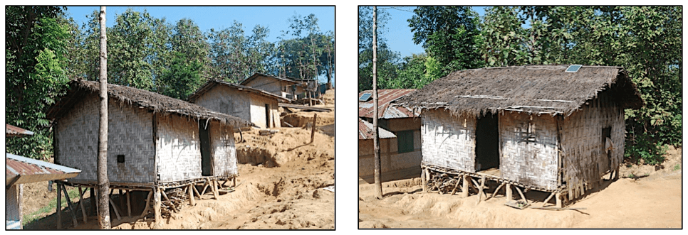
The typical tribal houses are made of locally available materials – bamboo, wood, mud and corrugated iron sheets. The foundation is laid on bamboo/tree trunks on a raised plinth from the ground and the roof is typically thatched.

Thanchi_Bayes_2Typical tribal housing – Sandak Para, Bandarban.

Tribal people have lived here permanently for few generations and no Bengali (people not living in the hills are called as Bengali/ settlers by the tribes) were found in the community. The traditional shifting cultivation (or slash and burn agriculture) is the primary occupation. There is no formal electricity supply, but people use solar power for household activities. There is no drainage network. Water supply is a major problem as people are mostly dependent on water from the Sangu River or from the nearby falls. The average monthly income of a household ranges from US$12-20 that is low earning in Bangladesh.

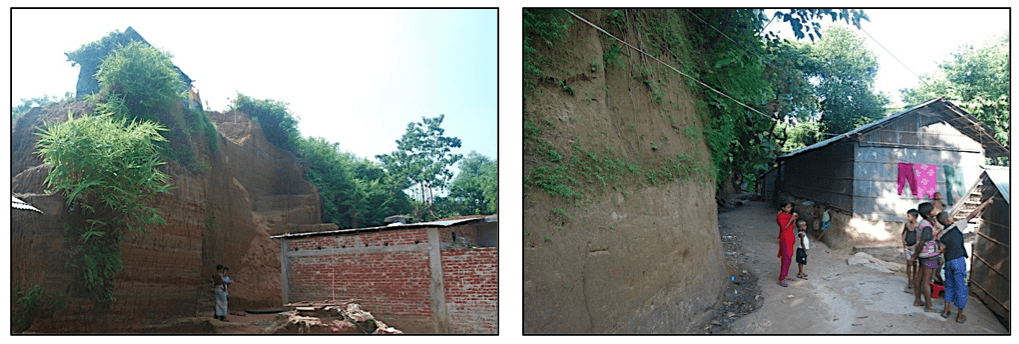
The architecture of the houses is helping to make the community physically less vulnerable to landslides. The raised plinth allows the rainwater to flow naturally and freely below the houses. The construction materials of the houses are lightweight and therefore not life threatening, even if the houses collapse in earthquakes or landslides. The tribal people do not cut the hills like in the urbanized areas, instead they try to build houses horizontally in the same line of hill-slopes using bamboo or tree trunks in layers. This is the indigenous knowledge applied by the tribal people to protect themselves from landslides or slope collapses.

Vulnerable Houses in CHDHouses built by cutting hills vertically in urbanized hill communities.

From initial observation, I found that the tribal communities are also addressing the different thematic dimensions of vulnerability in relation to landslides:

Economic dimension: alternative livelihood options, less damage to physical assets, and not using the hills for commercial activities.

Social dimension: no massive damage to social systems ranging from individual to collective, accessibility to necessary infrastructure and services, and social cohesion.

Cultural dimension: by treating the hills as sacred place and using centuries-old rich indigenous and local knowledge to deal with the hill environment.

Environmental dimension: protecting the hills by not destroying the hill-forests and cutting the hills in an unstable manner.

Institutional dimension: there are no power politics and few external influences; instead there is a strong local and regional network with autonomous administration.

From my fieldwork, it is evident that the indigenous tribal communities in CHD are more resilient to landslides than the urbanized settlers. It would be highly recommended to address community vulnerability by incorporating indigenous knowledge in local planning to reduce the risks of landslide disasters in the highly urbanized hill areas of Bangladesh.

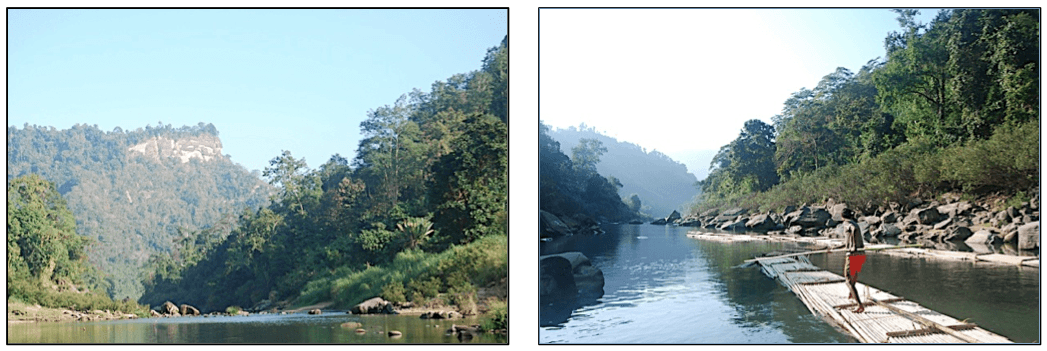
After several days of long and tiring work in the field, I took a boat ride with my field assistants; who are from the Marma tribe, in the Sangu River towards Remakri. The mesmerizing beauty of Sangu River, the surrounding green and untouched hills, the helpful tribal people, freedom from the chaotic and polluted city life and finally clean air and fresh food, all made me feel like I was in the most beautiful place on earth. I want to go back to this place again, just to enjoy the natural beauty and share some more moments with the indigenous tribal people of Bangladesh!

Bayes_4 Bayes_5Scenic beauty of Sangu River, Bandarban.

© Bayes Ahmed

Email: bayes.ahmed.13@ucl.ac.uk

Investigating communications after the Canterbury earthquakes – fieldwork

By ucfbtag, on 10 September 2015

Serena Tagliacozzo is a PhD student in the IRDR who is investigating the requirements for a web-based platform to allow effective communication between authorities and citizens in the disaster recovery phase. The platform would allow citizens to effectively share their knowledge and experiences with planners and developers, and for authorities to communicate plans to interested parties. Serena has recently visited Christchurch, NZ, to discuss with citizens and authorities the effects of the 2010 and 2011 earthquakes that destroyed parts of the city. She shares her experiences in this post.

me

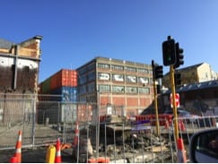
When I arrived in Christchurch, on the evening of the 8th August, it was dark and cold. The morning after, the city welcomed me with some snow, which fortunately stopped after few hours. Walking across the city centre, my impression was of a big construction site, with repair works in progress everywhere. The red cones dispersed throughout the city remains the symbol of the Christchurch’s struggle to recover from the devastating earthquakes that hit the Canterbury region in September 2010 and February 2011.

works

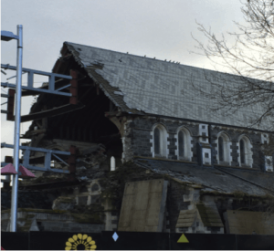
Following these two large events, the whole area experienced moderate to severe aftershocks for almost two years, making it more difficult for the repair companies to start the demolition/rebuilding of the damaged infrastructure and dwellings and for the population to return to normality. After almost five years from the earthquake of February 2011, Christchurch has now entered into the reconstruction phase. Many aspects of this reconstruction process remain controversial. For example the future of the Christchurch Cathedral (which dates back to the 19th century) is uncertain, with some people wanting to demolish it and rebuild a brand new one while others advocate preserving the historical building.

Christchurch Cathedral

The controversies do not exist solely on the rebuilding of the physical environment. The city is split socially, between those who experienced less damage and had their houses repaired in relatively short time, and those living in the most damaged areas whose property has not yet been repaired. For these people, most of who were living in the east part of the city where the liquefaction caused a drop in the ground level (which resulted in an increase of the flood risk), the recovery is far from being complete.

future

The scope of my fieldwork was to gather data on the communication practices that take place between government agencies and residents during the reconstruction phase from the Canterbury earthquakes. During the course of my fieldwork, I had the chance to interview and speak with many people from community based groups and associations born in the wake of the earthquake. All of them shared with me their stories of hope and the struggle to recover and to be listened to about their concerns for the future of their city. They also voiced a general distrust toward some of the authorities in charge with the management of the recovery process and concerns about the centralisation in the decision-making.

I also had the chance to interview and meet with government officers working in the main recovery agencies, including Christchurch City Council, Stronger Christchurch Infrastructure Rebuilding Team (SCIRT), Canterbury Earthquake Recovery Authority (CERA), Earthquake Commission (EQC), New Zealand Police, Red Cross, District Health Board. They told me about the challenges of leading a huge recovery effort and communicating effectively with increasingly frustrated residents. They also confirmed the importance of communicating timely and accurately recovery information through a multitude of channels so that to reach out to the different social groups. Within this communication landscape, social media platforms are being embraced by government agencies to reach a broader audience.

What I will take from this fieldwork is the incredible struggle of Christchurch and the Canterbury region to bounce back (or bounce forward). Whilst some choices made regarding the management of the recovery process are debatable, it should never be forgotten that recover from a disaster is a long-lasting, complex, challenging and sometimes nerve-wracking process. This is true for the residents that live through it, as well as for the government agencies that lead it. Good communication practices between recovery agencies and residents can make this process smoother and more participative.

Chilean Volcano Field Work

By Amy L Chadderton, on 10 February 2014

In 2008 Chaitén Volcano in Chile reawakened spectacularly after what was thought to be over 5000 years of slumber. In early May 2008 the residents of nearby Chaitén town received just 24 hours warning of the imminent eruption in the form of earthquakes strong enough to knock objects from shelves. Residents of the small town, known as the Gateway to Patagonia, one of Chile’s most spectacular and remote regions, evacuated themselves from their vulnerable position at the mouth of the Chaitén River, directly downstream of the volcano.

Eruption at Chaitén Volcano, May 2008 (Carlos Gutierrez)

Eruption at Chaitén Volcano, May 2008 (Carlos Gutierrez)

The eruption began explosively after all residents had safely departed the town and continued effusively for the next 2 years. What made this eruption particularly significant and thrust this small forgotten corner of the world into the global limelight was its extremely sudden onset coupled with the fact that rhyolitic eruptions are so rare that this eruption was the first to be observed in over 100 years. This rarity meant that it was an extremely appealing case study to focus my PhD research on, and an even more appealing place from which to collect experimental samples. This fascination is what led to myself and 6 colleagues, including Professor Peter Sammonds (UCL) and Dr Hugh Tuffen (Lancaster University), to set out on New Years Eve 2013 on the mammoth journey to Southern Chile to visit this incredible volcano.

After four flights, the last of which was in a 9-seater aeroplane that landed on a landing strip that doubled as a main road when flights weren’t expected, and two days, we finally made it to the trailhead of the hike up to the crater rim of Chaitén Volcano.

Professor Peter Sammonds, Amy Chadderton, Dr Hugh Tuffen setting off to Chaiten dome

Setting off up the volcano

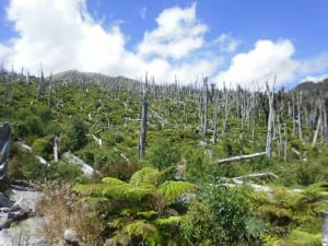
This relatively short yet steep hike up the flank of the volcano took us up through the blast zone, an area of once-dense forest that was destroyed by pyroclastic flows generated from the eruption. An encouraging sign of recovery on these slopes was the re-colonisation of vegetation where previously only sporadic trees stripped of all foliage and bark remained standing.

Vegetation regrowth in blast zone

Vegetation regrowth in blast zone

Reaching the crater rim and seeing Chaitén’s 400m lava dome come into view was an awe-inspiring sight. Its imposing size and impressive slopes made for some unforgettable first impressions from the rim. We set up camp on the crater rim as the sun was setting and took in the spectacular scenery.


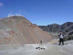
Despite my enthusiasm for the field trip, I must admit that the descent into the crater the following day was not my favourite activity. The 50m scramble down the perilous near-vertical unconsolidated slope was a challenge, but the end location definitely made the journey worth it. Gazing up at the dome from the crater floor allowed us to fully appreciate its true magnitude.


Most of the dome’s lower slopes are covered in scree, but small intact outcrops offered us tantalizing glimpses into the make-up of the dome itself. It was from one of these outcrops on the earliest lobe of the eruption that I collected my largest sample of rhyolite. Weighing in at 26kg it proved a challenge to transport but hopefully will provide an excellent insight into how this rhyolitic dome formed. Littering the crater floor we also found a plethora of incredibly interesting samples. I collected 3 more large blocks of sample material from the crater floor, including a 7kg piece of an obsidian volcanic bomb. As we could only collect what we could carry we had to be selective, however, and several large volcanic bombs had to be admired and recorded but alas left where we found them. With the help of Hugh and Peter and two trips down the volcano I managed to collect 55kg of sample material from Chaitén Volcano, making it a very successful field trip indeed!

Chaitén Lava Dome

Chaitén Lava Dome

The samples collected from Chaitén will enable me to better understand the dynamics of the 2008 eruption via laboratory analogue experiments. I will measure the permeability of cored samples under volcanic conditions simulated in the lab in order to help determine how gas escapes from the volcano during eruptions. Gas escape greatly influences the dynamics of the eruption and ultimately how dangerous a volcano can be.

Arctic Field Training in Svalbard (Spitsbergen)

By Stanislav Pavlov, on 29 April 2013

Arctic sea ice cover has had a high profile in the media over the last few years. There has been a growing interest in the region from across the scientific community, such as oceanographers and marine engineers in particular. The Arctic ice cover has reduced, allowing increasing access to the natural resource base in the arctic and has the potential to open new shipping routes.

As part of my PhD project researching the risks of Arctic offshore operations we were invited to participate in a field training course organized by the University Centre of Svalbard (UNIS) in Svalbard – far in the Arctic north. Together with Prof. Peter Sammonds we left the relative luminosity and warmth of London to arrive in Longyearbyen, the world’s northernmost town at 78°North, during the peak of the polar night season.

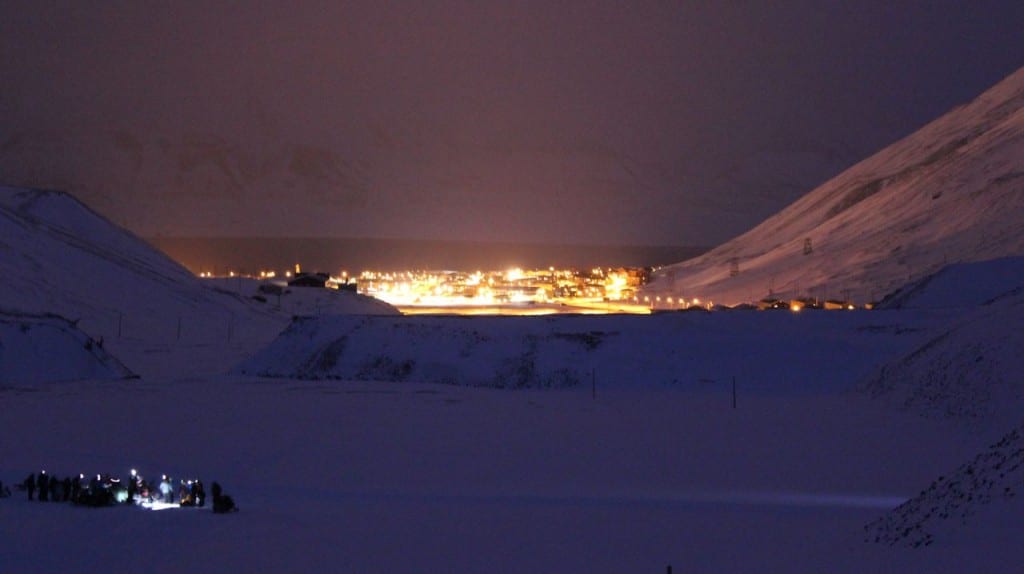
Field training in the afternoon with Longyearbyen town in the background

Field training in the afternoon with Longyearbyen town in the background

Over the course of one week we practiced skills, both indoors and in the field, essential for work in the Arctic region. These included first aid, sea and emergency rescue, rifle training, crevasse and avalanche rescue etc.  Activities that would otherwise seem relatively mundane were much more difficult to accomplish in the freezing cold. Tasks such as setting up camp or equipment, were made much more difficult by several layers of clothing and necessitated efficient team effort. The wind and visibility were key unpredictable variables that would change the conditions in a very short space of time.

It was refreshing to see many participants in the safety course, highlighting the number of scientists who are working on understanding the arctic environment. The equipment given to participants in field experiments was excellent and the rescue service in Svalbard was second to none.

During our stay we understood the importance of the skills needed to operate in this fragile and ever changing environment. In addition we were in an excellent position to observe and absorb the unusual Arctic environment. In particular we were surprised to find that the ice cover did not extend to the main part of the island, and was only partially covering the northeasterly corner of the island. This was not surprising as the ice cover has been at its lowest levels in past few years.

It was easy to see that with the lower levels of ice cover, an increasing exploration of these areas will be very likely in the near future. As with any oil exploration there are many risks involved in the operations. The key for our research at IRDR is to research the associated risks involved in such activities. So far there have not been any major incidents in the Artic seas, but with ever increasing activity in the region the understanding of the risks is vital in preventing and dealing with any possible future disasters.

Svalbard Rescue Services demonstrating a rescue operation with a Super Puma helicopter

Svalbard Rescue Services demonstrating a rescue operation with a Super Puma helicopter

Our visit to the Arctic was an amazing experience and the completion of the safety course will allow us to participate in future fieldwork projects within Svalbard and obtain valuable field data to further our understanding of the Arctic sea ice.

Fieldwork in Abruzzo: Four years on from L’Aquila

By Luke N J Wedmore, on 19 April 2013

With the 4-year anniversary of the devastating L’Aquila earthquake occurring in the middle of my first PhD fieldtrip to Italy, the importance of studying active faults in the Abruzzo region remained at the front of my thoughts throughout my trip. The aim of the trip was to use Laser scanning (LiDAR) and ground penetrating radar (GPR) to increase our understanding of the active earthquake faults in the area. The group comprised Dr. Joanna Faure Walker (UCL IRDR), Dr. Ken McCaffrey (Durham University) and Dr. Laura Gregory (University of Leeds).

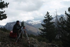
Dr. Ken McCaffrey (Durham University) using LiDAR to scan active normal faults in Abruzzo

Dr. Ken McCaffrey (Durham University) using LiDAR to scan active normal faults in Abruzzo

The first week was spent collecting GPR and LiDAR data along active faults, while the second week was spent hunting for potential future data collection sites. The active normal faults in this area can be seen in the landscape due to the existence of prominent limestone bedrock fault scarps on the side of steep mountains. However, such fault scarps are not present everywhere; for example, part of the fault responsible for the 1915 Avezzano earthquake that killed over 30,000 people crosses the Fucino plain. The Fucino basin is a former lake bed that was drained in the 1800’s. Consequently, the fault scarp has been obscured by erosion from the lake and more recently by intensive farming. LiDAR scans of sites along the fault trace within the plain ensure that we have a 3D digital image of the current state of the fault.

LiDAR scanning on the Fucino Plain

During the course of the two-week trip I visited 10 active faults across the region of Abruzzo and collected large quantities of data to process over the coming months. Visiting the faults for the first time was invaluable to my understanding of the earthquake hazard and overall seismic risk that people in the area are subject to.  Observing spectacular villages that cling to the sides of mountains located in the hanging walls of active faults and larger towns in the basins below highlighted the potentially devastating impact earthquakes in the area could have.  The results of my work will feed into a larger NERC funded study which aims to determine the time since each active fault last produced an earthquake; being a first year PhD student, this is a fantastic opportunity for me and I am looking forward to contributing to such an innovative and exciting project.