X Close

The Survey of London

Home

Recording the history of London's built environment since 1894

Menu

Archive for the 'Whitechapel' Category

Whitechapel Bell Foundry

By the Survey of London, on 14 May 2021

It was announced today that permission is to be granted for a hotel conversion of the Whitechapel Bell Foundry. It is timely, and sad, to repost this account from December 2016.

On 2 December it was announced that the Whitechapel Bell Foundry will close in May 2017. This will mark the end of what has been a remarkable story. Business cards claim the bell foundry as ‘Britain’s oldest manufacturing company’ and ‘the world’s most famous bell foundry’ – the first not readily contradicted, the second unverifiable but plausible. It has been said that the foundry ‘is so connected with the history of Whitechapel that it would be impossible to move it without wanton disregard of the associations of many generations.’[1] The business, principally the making of church bells, has operated continuously in Whitechapel since at least the 1570s, on its present site with the existing house and office buildings since the mid 1740s.

Project: Site: Whitechapel Bell Foundry, 32-34 Whitechapel Road, Tower Hamlets, London. Exterior, view fron north.

Shopfront at the east end of 32–34 Whitechapel Road in 2010 (© Historic England Archive, photographed by Derek Kendall)

The foundry’s origins have been traced to either Robert Doddes in 1567 or Robert Mot in 1572, giving rise to a traditional foundation date of 1570. It is said then to have been in Essex Court (later Tewkesbury Court, where Gunthorpe Street is now). There is no continuous thread, but it has also been suggested that the Elizabethan establishment had grown out of a foundry in Aldgate that can be tracked back to Stephen Norton in 1363.
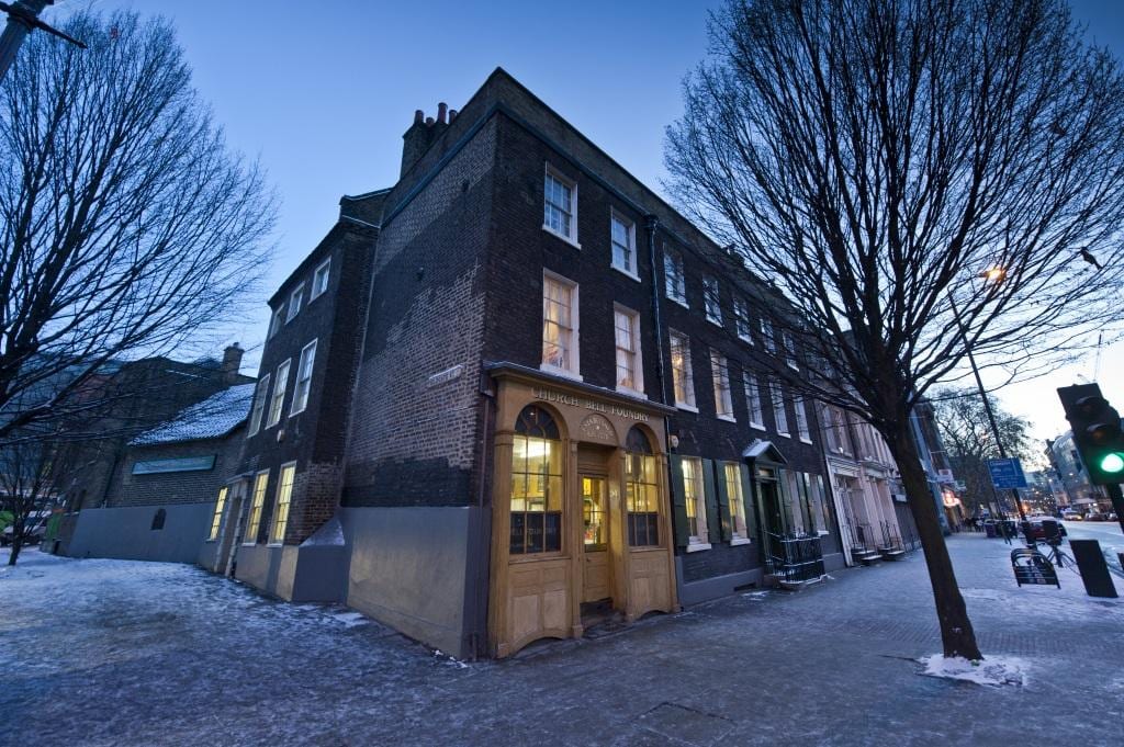
Project: Site: Whitechapel Bell Foundry, 32-34 Whitechapel Road, Tower Hamlets, London. Exterior, view fron north east.

Whitechapel Bell Foundry in 2010, from the north-east at the corner of Whitechapel Road and Plumber’s Row (© Historic England Archive, photographed by Derek Kendall)

From 1701 Richard Phelps was in charge. He made the great (5¼ ton) clock bell for St Paul’s Cathedral in 1716. When he died in August 1738 he was succeeded by Thomas Lester, aged about 35, who had been his foreman. It has been supposed that within the year Lester had moved the foundry into new buildings on the present site on Whitechapel Road, a belief which can be traced to Amherst Tyssen’s account of the history of the foundry in 1923, where he related that ‘according to the tradition preserved in the foundry and communicated to me by Mr John Mears more than sixty years ago, Thomas Lester built the present foundry in the year 1738 and moved his business to it. The site was said to have been previously occupied by the Artichoke Inn.[2] That has never been corroborated and it is implausible as such a move would take more than a few months.
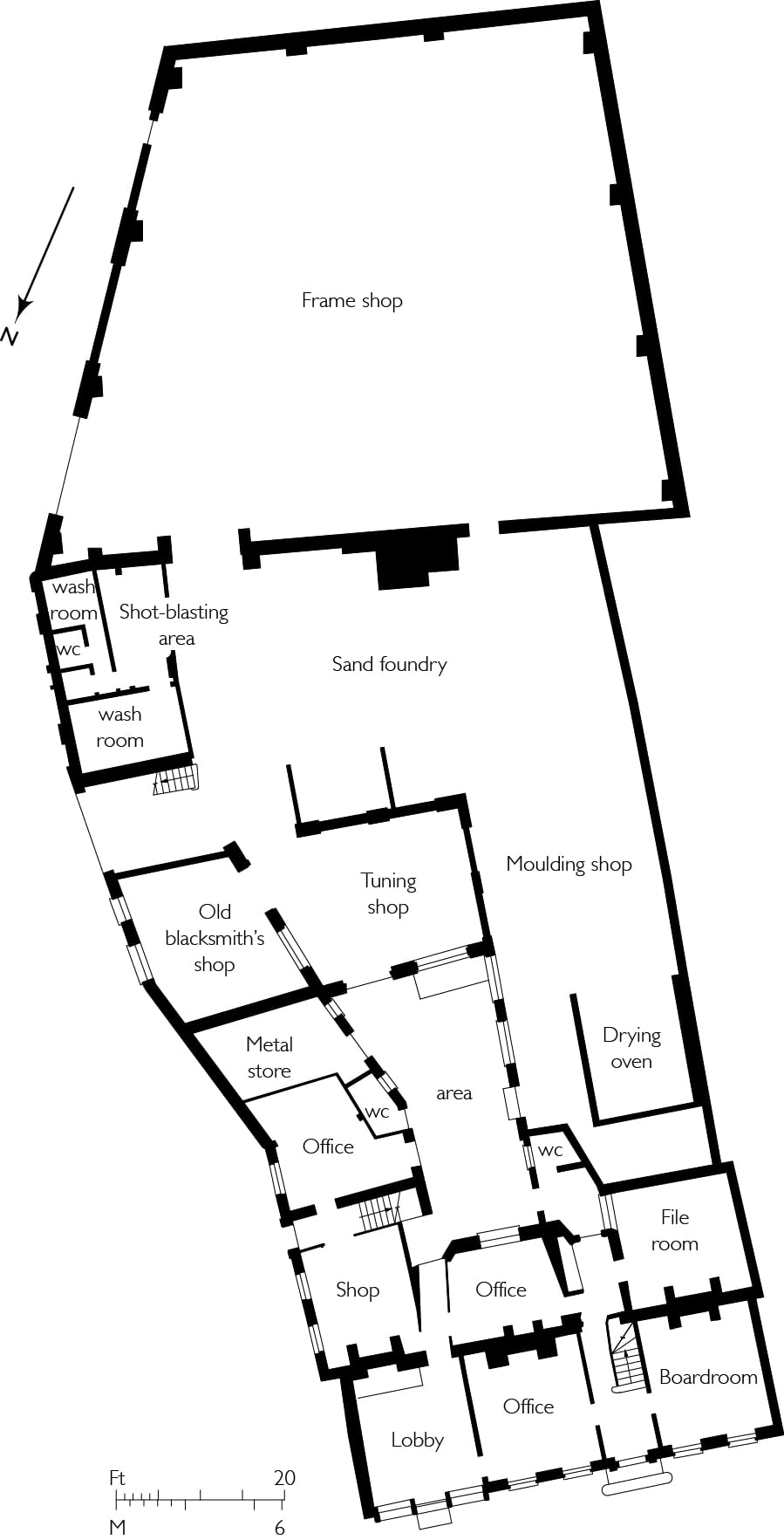
bell foundry ground floor plan

Ground-floor plan of the Whitechapel Bell Foundry (Survey of London, Helen Jones)

Contemporary documentation suggests a slightly later date for the move. An advertisement in the Daily Advertiser of 31 August 1743 reads: ‘To be let on a Building Lease, The Old Artichoke Alehouse, together with the House adjoining, in front fifty feet, and in Depth a hundred and six, situated in Whitechapel Street, the Corner turning into Stepney Fields.’ Those measurements tally well with the foundry site. Stepney Manor Court Rolls (at London Metropolitan Archives) refer to ‘the Artichoke Alehouse, late in the occupation of John Cowell now empty’ on 8 April 1743 and to ‘a new built messuage now in possession of Thomas Leicester, formerly two old houses’ on 15 May 1747. A sewer rates listing of February 1743/4 does not mention Lester at the site. The advertised building lease was no doubt taken by or sold on to Lester, who undertook redevelopment of the site in 1744–6, clearing the Artichoke. The motive for the move would have been the opportunity for a larger foundry and superior accommodation on this more easterly and therefore open site.
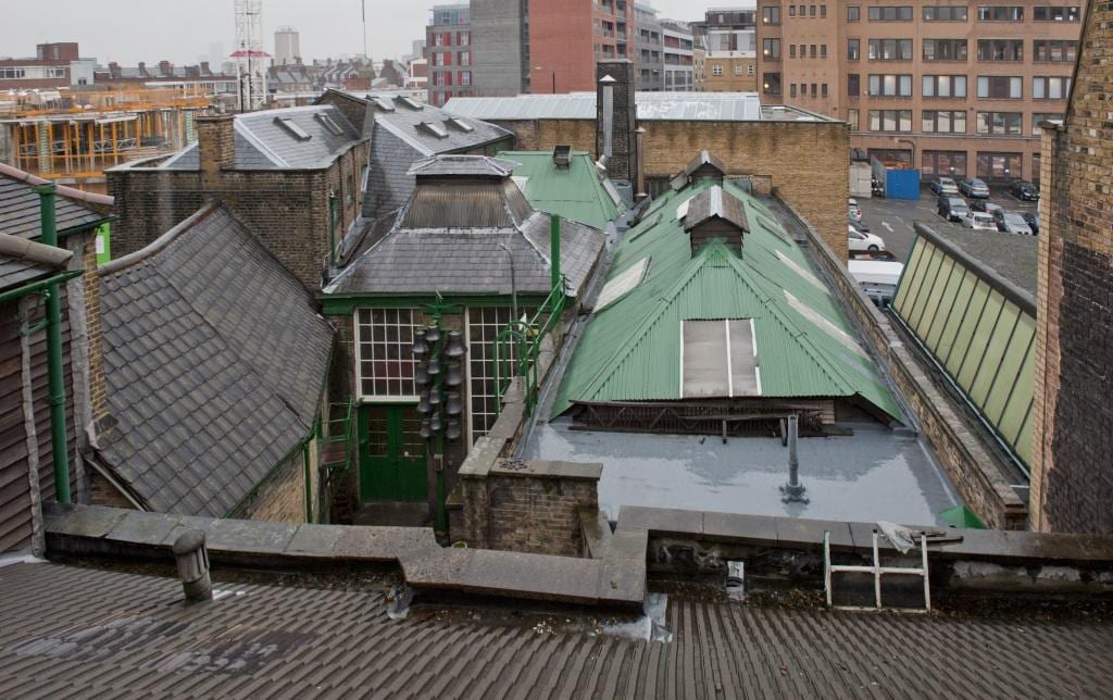
Project: Hidden London Site: Whitechapel Bell Foundry, 32-34 Whitechapel Road, Tower Hamlets, London. Exterior, roofscape over house.

View of the Bell Foundry’s workshops from the roof of the front range, looking south in 2010 (© Historic England Archive, photographed by Derek Kendall)

The seven-bay brick range that is 32 and 34 Whitechapel Road is a single room deep with three rooms in line on each storey, all heated from the back wall. It was built to be Lester’s house and has probably always incorporated an office. The Doric doorcase appears to be an original feature, while the shopfront at the east end is of the early nineteenth century, either an insertion or a replacement. Internally the house retains much original fielded panelling, a good original staircase, chimneypieces of several eighteenth- and nineteenth-century dates and, in the central room on the first floor, a fine apsidal niche cupboard. Behind the east end is 2 Fieldgate Street, a separately built house of just one room per storey, perhaps for a foreman. Its Gibbsian door surround is of timber, as is its back wall.
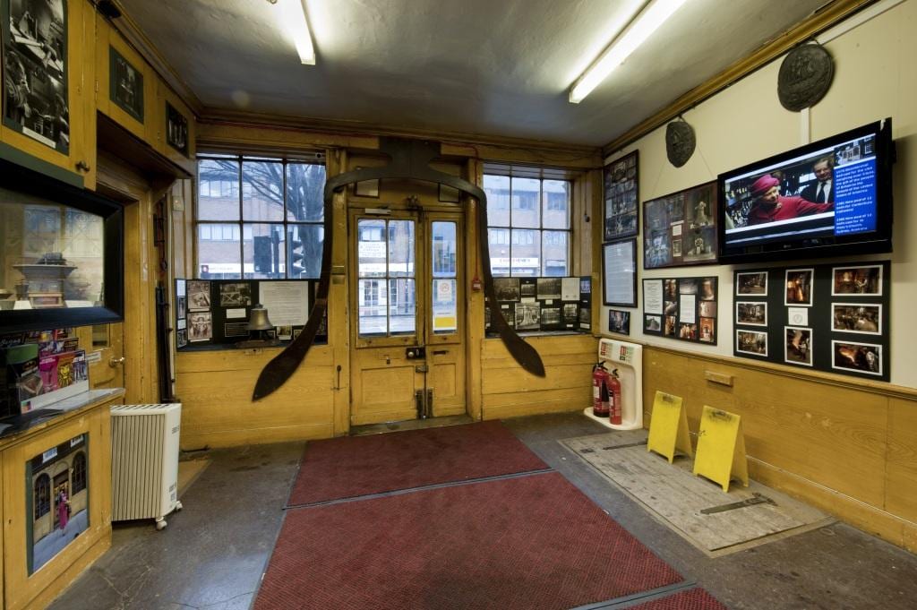
Project: Hidden London Site: Whitechapel Bell Foundry, 32-34 Whitechapel Road, Tower Hamlets, London. Interior of shop with casting profile of Big Ben over door..

The ground-floor front ‘lobby’ (former shop) at 34 Whitechapel Road in 2010, showing the casting profile of Big Ben over the front door (© Historic England Archive, photographed by Derek Kendall)

Eighteenth-century outbuildings to the south are single storeyed: a former stables, coach-house and smithery range along Fieldgate Street; and the former foundry (latterly moulding shop) itself, across a yard behind the west part of the house. Facing the street on the former stabling range is a tablet inscribed: ‘This is Baynes Street’ with an illegible date, perhaps 1766, a reference to what later became Fieldgate Street. This junction, which now incorporates Plumber’s Row, bisected property owned by Edward Baynes from 1729.
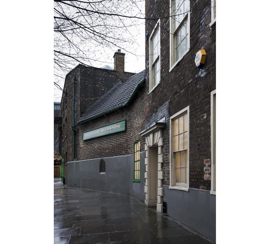
Project: Hidden London Site: Whitechapel Bell Foundry, 32-34 Whitechapel Road, Tower Hamlets, London. Etxrior, side elevation to Plumbers Row.

Plumber’s Row range in 2010 (© Historic England Archive, photographed by Derek Kendall)

Tablet inscribed ‘This is Baynes Street’ on the foundry’s former stabling range (© Historic England Archive, photographed by Derek Kendall)

Thomas Lester took Thomas Pack into partnership in 1752 and acquired ownership of the foundry from a younger Edward Baynes in 1767. Lester’s nephew William Chapman was a foundry foreman who, working at Canterbury Cathedral in 1762, met William Mears, a young man he brought back to London to learn the bell-founding trade. Lester died in 1769 and left the foundry to relatives to be leased to Pack and Chapman as partners. After Pack died in 1781 Chapman was pushed out and for a few years descendants of Lester ran the establishment. Their initiative failed and William Mears returned in partnership with his brother Thomas, who came to Whitechapel from Canterbury. Ownership of the property remained divided among descendants of Lester and in 1810 Thomas Mears was still trading as ‘late Lester, Pack and Chapman’. On a promotional sheet he listed all the bells cast at the foundry since 1738, 1,858 in total, around 25 per year – including some for St Mary le Bow in 1738, Petersburg in Russia in 1747, and Christ Church, Philadelphia, in 1754.
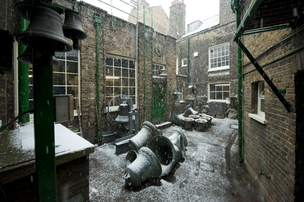
Project: Site: Whitechapel Bell Foundry, 32-34 Whitechapel Road, Tower Hamlets, London. Exerior, bells in courtyard.

Inner yard of the bell foundry, looking north-west in 2010 (© Historic England Archive, photographed by Derek Kendall)

A son, also Thomas Mears, acquired full control of the foundry in October 1818 when Lester’s descendants sold up. The younger Mears took over the businesses of four rival bell-founders and undertook works of improvement. By 1840 the firm had only one major competitor in Britain (W. & J. Taylor of Oxford and Loughborough). The next generation, Charles and George Mears, ran the foundry from 1844 to 1859, the highlight of this period being the casting in 1858 of Big Ben (13.7 tons), still the foundry’s largest bell. From 1865 George Mears was partnered by Robert Stainbank. Thereafter the business traded as Mears & Stainbank up to 1968. Arthur Hughes became the foundry manager in 1884 and took charge of operations in 1904.

Project: Site: Whitechapel Bell Foundry, 32-34 Whitechapel Road, Tower Hamlets, London. Exerior, bells in courtyard.

Inner yard of the bell foundry, looking south in 2010 (© Historic England Archive, photographed by Derek Kendall)

Given the ownership history, there was little significant investment in the buildings before 1818. However, the smithery end of the eastern outbuilding does appear to have been altered if not rebuilt between 1794 and 1813. Around 1820 a small pair of three-storey houses was added beyond a gateway that gave access to the foundry yard. There are also early nineteenth-century additions behind the centre and west bays of the main house, the last room incorporating a chimneypiece bearing ‘TM 1820’. Thereafter, possibly following a fire in 1837 or in the 1850s, the smithery site was redeveloped as a three-storey workshop/warehouse block extending across a retained gateway. In 1846 the foundry was enlarged with a new furnace by enclosing the south end of the yard, to make an 11.5 ton bell for Montreal Cathedral. Another furnace was added in 1848 when a tuning machine was housed in a specially built room that ate further into the yard with a largely glazed north wall. Two years later a 62ft-tall chimney was erected against the south wall. A large additional workshop or back foundry had been added to the far south-west by the 1870s, by when the pair of houses to the south-east had been cleared for a carpenter’s shop, the front wall retained with its doors and windows blocked. The whole Plumber’s Row range has latterly been used for making handbells and timber bell wheels.
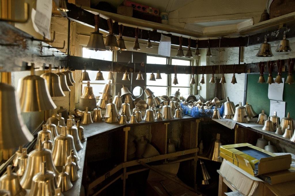
Project: Site: Whitechapel Bell Foundry, 32-34 Whitechapel Road, Tower Hamlets, London. Interior, hand bell blanks.

Handbell workshop in 2010 (© Historic England Archive, photographed by Derek Kendall)
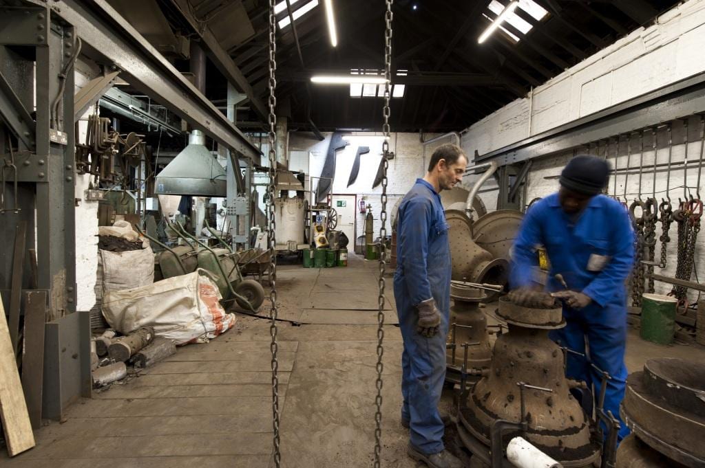
Project: Site: Whitechapel Bell Foundry, 32-34 Whitechapel Road, Tower Hamlets, London. Interior, casting room, preparing the moulds.

Moulding shop, showing moulds being prepared in 2010 (© Historic England Archive, photographed by Derek Kendall)

The back foundry was damaged during the Second World War. Proposals to rebuild entirely behind the Whitechapel Road houses emerged in 1958 by when the foundry was already protected by listing. The workshops were considered expendable, but even then it was suggested that the timber jib crane on the east wall should be preserved. First plans were shelved and a more modest scheme of 1964–5 was postponed for want of capital, though plant and furnaces were replaced and there were repairs. In 1972 Moss Sprawson tried to acquire the site for office development. For the foundry, Douglas Hughes (one of Arthur’s grandsons) proposed a move east across Fieldgate Street to what was then a car park owned by the Greater London Council. A move entirely out of London was also considered. The GLC’s Historic Buildings Division involved itself in trying to maintain what it considered ‘a unique and important living industry where crafts essentially unchanged for 400 years are practised by local craftsmen.’[3] But plans came unstuck again in 1976 when the GLC conceded it had no locus to help keep the business in situ. In the same year the UK gave the USA a Bicentennial Bell cast in Whitechapel.

A large new engineering workshop was at last built in 1979–81, with James Strike as architect. At the back of the site, it was faced with arcaded yellow stock brick on conservation grounds. In 1984–5 the GLC oversaw and helped pay for underpinning and refurbishment of the front buildings. The shopfront was grained and the external window shutters were renewed and painted dark green. In 1997 proprietorship passed to Douglas Hughes’s nephew, Alan Hughes, and his wife, Kathryn. The foundry has since continued to manufacture, though not without growing concerns as to its tenability in Whitechapel. Now the Hughes have announced that the foundry will close in May 2017 after sale of the site. The future of the business is to be negotiated.

We are very grateful to Alan Hughes for showing us round the premises and sharing his knowledge of the foundry.

The Survey of London has launched a participative website, ‘Histories of Whitechapel’. Please visit at: https://surveyoflondon.org. We welcome contributions from any and all. For more information about the Whitechapel Bell Foundry, and to add your memories and photographs, please visit https://surveyoflondon.org/map/feature/155/detail/.
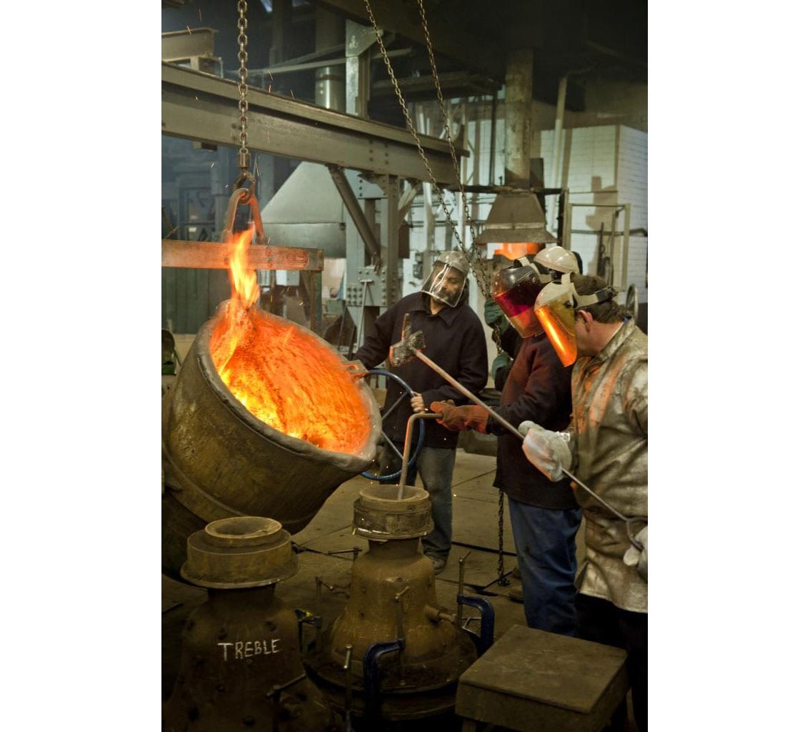
Project: Site: Whitechapel Bell Foundry, 32-34 Whitechapel Road, Tower Hamlets, London. Interior, casting room, filling the moulds.

Sand foundry, filling the moulds in 2010 (© Historic England Archive, photographed by Derek Kendall)

Project: Site: Whitechapel Bell Foundry, 32-34 Whitechapel Road, Tower Hamlets, London. Interior, bell tuning room.

Tuning shop in 2010 (© Historic England Archive, photographed by Derek Kendall)

Project: Site: Whitechapel Bell Foundry, 32-34 Whitechapel Road, Tower Hamlets, London. Interior, bell store, recently cast bells.

Bell recast in 2010 (© Historic England Archive, photographed by Derek Kendall)

References

[1] D. L. Munby, Industry and Planning in Stepney, 1951, p. 254

[2] Amherst D. Tyssen, ‘The History of the Whitechapel Bell-Foundry’, Transactions of the London and Middlesex Archaeological Society, vol. 5, 1923, p. 211

[3] London Metropolitan Archives, LMA/4441/01/0821

The former ‘Colonial House’, 17 Leman Street, Whitechapel

By Survey of London, on 23 October 2020

In the nineteenth century, East London was referred to as the Deutsche Kolonie by the German community and ‘our London ghetto’ by the Jewish community. For British sociologist Michael Banton, by 1955 Stepney could comfortably be regarded as ‘The Coloured Quarter’, its identification as a centre for post-war Afro-Caribbean settlement coming under wider public scrutiny as a result of regular letters in the national press criticising government authorities for inaction in the provision of housing.

A number of groups commissioned surveys which aimed to assess the welfare and living conditions of the East End’s Black community, concerned about issues of segregation in the built environment and acutely aware of the dangers of ‘ghettoization’. The experience of the unofficial ‘colour bar’ on resident Black seamen was of especial interest in these studies. During the Second World War and afterwards, Britain politicians did not generally and overtly support segregation. Yet discrimination was by no means absent in British space, and a de facto segregation cut across both private and public urban spaces. Reports suggested that the bar was most evident in port cities like London. For Black seamen in wartime and post-war East London, the existence of a colour bar was indisputable.

From the 1940s, the so-called ‘coloured question’ in London’s East End was a matter of strategic importance for government authorities. The provision of accommodation for seamen was one aspect of this question. Seamen’s hostels had become an issue during the war, responsibility for the ‘special wartime measure’ for seamen from the colonies given over to the Colonial Office, with increasing resources diverted to attend to these men after the Colonial Development and Welfare Act of 1940 was passed. Colonial labour to support the war effort had been actively sought, with recruitment calls made in British colonies in the West Indies and West Africa, yet onshore accommodation for sailors prioritised white British seamen. In an attempt to redress this imbalance, 17 Leman Street, Whitechapel, was acquired by the Colonial Office in 1942 and converted into the only seamen’s hostel for Black men in London. For less than a decade, this small government-sponsored hostel provided thirteen beds for seamen from British colonies in the Caribbean and West Africa.

17 Leman Street in 2007, photograph by Danny McLaughlin, from surveyoflondon.org

The Colonial Office was in fact involved in the establishment of a national network of ‘Colonial Houses’. Whilst often small in scale, seamen’s hostels such as the one in Whitechapel can be seen as flashpoints for discontent as the national identity and rights of Black migrants from British colonies were contested by employers, activists, local and government authorities and the men themselves, against the backdrop of emerging understandings of race relations in the United Kingdom.

Built in 1861–3 as a German Mission School, the two-storey hostel was situated at the north end of Leman Street, near Whitechapel High Street, until demolition in 2008 to make way for a twenty-three storey tower hotel of short-stay serviced apartments (15–17 Leman Street). Despite functioning for less than a decade as a government-funded hostel that was the subject of some local controversy, Colonial House was well-documented as a result of its connection to the Colonial Office and a group of tireless East London campaigners. Bert Hardy made a series of black-and-white photographs in 1949.

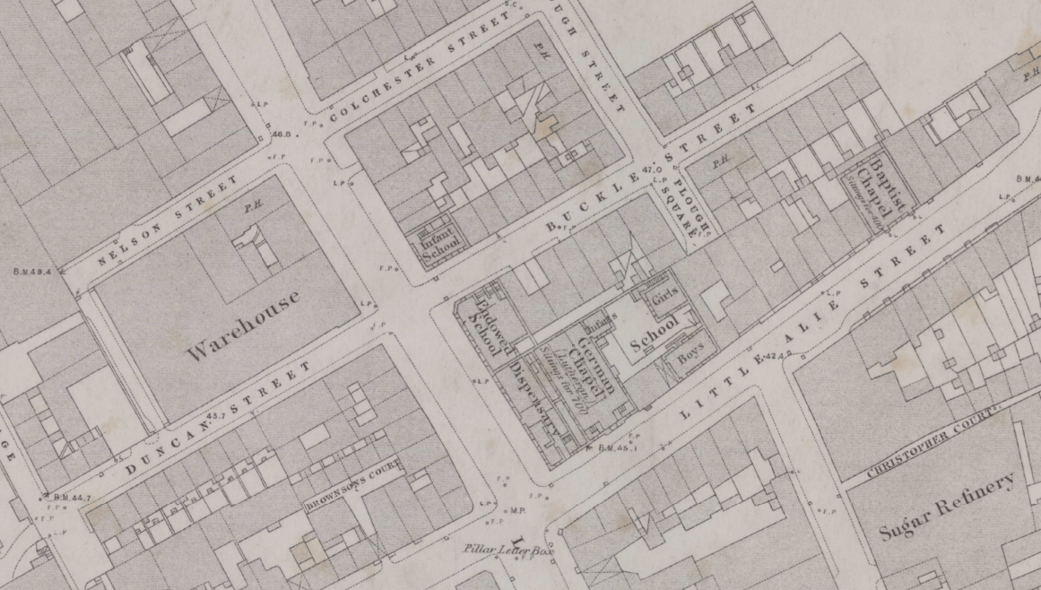
Paternalistic welfare provision for migrant communities was well-established in the Leman Street building long before use as the Colonial House hostel. It was constructed to host education, recreation and acculturation activities for diasporic groups, firstly German Christians and then East European Jews. The German Mission Day School replaced an eighteenth-century tenement and bakery on the site in 1861–3. The purpose-built school was one of a handful of educational buildings clustered on Buckle Street and the east end of Alie Street. This group of buildings was fashioned primarily to serve a large local German population that was closely associated to the sugar-refining business during the eighteenth and nineteenth centuries. The school was designed by Edward Ellis, a London architect better known for his work on offices and warehouses. With a long elevation to Buckle Street and a steeply pitched gable roof, the two-and-a-half storey building assumed an institutional Gothic Revival style, typical of its time. It was formed of London stock brick with black- and red-brick headed arched openings. A large ground-floor corner schoolroom was accessed through decorated double-doors located in a narrow wing extension facing onto Leman Street. An office and further large schoolroom were on the first floor. The top floor provided separate living accommodation for the school’s two teachers. In its unassumingly reserved exterior, the school was matched by other buildings constructed for the local German community, none of which sought to broadcast their ‘alien’ status.

Ordnance Survey map of 1873 showing the infant school at the junction of Leman Street and Buckle Street

By the end of the century, with many German families having moved out of Whitechapel to more salubrious suburbs and many free English schools in operation, leaders concluded that the ‘German Poor School’ should be given up. It closed in 1897 and the schoolhouse was let out for commercial purposes, the rent channelled into funding German education in other parts of the capital.

By 1903 the former school building was in use by the Jewish Working Girls’ Club (JWGC). The purchase of the leasehold was made possible through the support of one individual, (Lady) Julia Henry, daughter of the prominent Jewish-American philanthropist, Leonard Lewisohn. Henry’s support was prompted by an anxiety to show American goodwill towards English Jews in the light of tightening immigration policies in the US, which restricted Jewish movement into the country as religious refugees. The former Mission School was adapted without significant architectural alteration to suit its new purpose by the architect M. E. Collins, who, on completion, reported that the Club contained ‘every accommodation, including the usual recreation rooms, a kitchen, scullery, library and other rooms’. [1] The day-to-day running of the Club was reliant on voluntary contributions and teachers were mostly volunteers from the well-meaning and already settled middle classes, concerned that the assimilation of poor Jewish children from Eastern Europe was occurring neither rapidly nor effectively enough. With 160 girls regularly attending evening and Sunday classes in such subjects as needlework, cooking, Hebrew and religion, singing and drilling in the early 1900s, the Club ‘exceedingly flourish[ed]’ well into the 1920s. [2] The JWGC appears to have continued on until at least the late 1930s before closure around the beginning of the Second World War, the Jewish exodus from East London ‘well-nigh complete’ by the late 1950s.

Requisitioned for use by the War Office soon after the outbreak of war, the former school became a hostel for Black seamen from the British colonies in 1942. In spite of a proliferation of local seamen’s hostels, ‘coloured colonials’ were frequently turned away or were reticent to take up beds reserved for them in larger hostels, aware that their very presence might result in social unrest, as it had in the recent past.

The Colonial Office hostel at Leman Street was intended for thirteen seamen, whose stay was limited to a maximum of three weeks on the basis that they were only temporary residents awaiting their next contract at sea. Accommodation included a basement dining room and kitchen, a ground-floor common room and office, with a large open dormitory, and a small adjoining bedroom on the first floor. The self-contained second-floor flat once home to the German teachers was assigned to the hostel’s warden. Equipped with a billiard table and piano, the common room was intended to serve an important social function, where, it was envisioned, ‘men can sit and talk’. But in the extent of its provision and the effectiveness of its organisation, the small hostel fell woefully short, dogged by problems from its inception and only deepening after the end of the war. Three successive wardens failed to maintain order in the house as men arriving at the hostel often struggled to find places on ships leaving the port, overstayed and grew restless. Although intended only as a place of short-stays for ‘the floating population’, the hostel frequently housed teenage stowaways and those with longer-term ambitions to settle permanently in the country. Local boarding-house keeper Kathleen Wrsama despaired at the lack of support given to these men, who arrived with little or no knowledge of the culture and institutional systems in England. She recalled, ‘The Colonial Office opened a house and you know what it was known as? It was known as the government gambling den. I used to laugh at that. They did nothing for the poor boys’. [3]

Cafés around the west end of Cable Street, often run by former seamen, formed a valuable network of informal social spaces through which private lodging places could be found. A pattern of friendly association brought men into this alternative economy, as former colleagues set up unregistered lodging houses hosting a circuit of friends and friends of friends who arrived after a period of time at sea. Along Cable Street, three-storey bomb-damaged terraced houses in a state of considerable disrepair accommodated cafés on the ground floor, dancing clubs in the basement, and bedrooms on the upper floors. In 1944, thirty-four such humble cafés were identified. African-origin men were the most affected by deficient housing conditions. Derek Bamuta noted, ‘I have reason to suspect that a lot of them actually sleep in bombed out houses’ after having wandered the streets until the early hours of the morning.’ [4] By 1950, those living in unofficial lodgings in the Cable Street area were deemed to be enduring the worst possible conditions. Once settled in temporary accommodation, there were few opportunities for Black tenants to move out of the area; many white landlords would not accept them.

Much to the dismay of local activists such as Edith Ramsay, a councillor, and Father St John Beverley Groser, who saw Colonial House as tokenistic, by 1946 inefficient management of the hostel had caused the Colonial Office to quietly close it only for it to be hastily re-opened soon after. For Ramsay, this episode was evidence of a dereliction of public duty and the abandonment of principles set out in legislation such as the Colonial Development and Welfare Act 1940 which shifted government policy away from a laissez-faire attitude to the colonies and its peoples towards investment in their social, physical and economic needs. The hostel was consistently oversubscribed, with Ramsay reporting that up to forty men could be packed into the building using mattresses on the floor in the mid-1940s. It only catered for a very small percentage of non-resident seamen, and left the needs of the wider resident ‘coloured’ community entirely unattended.

Closure of the tiny Colonial House became representative of what was perceived to be central government’s confused policy and piecemeal approach to the issue of housing British ‘colonials’ in the UK. After a visit to the Leman Street hostel in 1944, a shocked civil servant, Frank de Halpert, exclaimed, ‘Here we are in the greatest city in the world, with the largest colonial empire, and that is the hostel we offer!’ Linking it to a broader political disregard for British territories overseas, he assessed ‘it is on a par with our [political] treatment of the colonies to which in Parliament we devote one or at most two days per annum’. [5]

The London County Council (LCC) also recognised the housing shortage that was affecting growing numbers of Afro-Caribbean men, and particularly seamen, who continued to arrive in the East End. But it held that responsibility to provide suitable hostels for this group lay firmly with the Colonial Office. On the basis that the East End Welfare Advisory Committee would provide essential advice on the running of the hostel, the LCC persuaded the Colonial Office to defer permanent closure of the Leman Street hostel. With the inadequacy of the hostel provision more widely accepted than before, after re-opening discussions turned to consider the construction of a large purpose-built hostel to accommodate approximately 100 men. The bomb-damaged site of St Augustine’s Church on Settles Street was surveyed, as was a property on Wellclose Square, and another on Dock Street, but at the last minute the Colonial Office unexpectedly withdrew its support for the scheme. The existing thirteen-bed hostel muddled on.
Closure of Colonial House was again announced in October 1949. Hopes of a new centre had long since dissipated; blindsided local campaigners felt their considerable efforts to improve conditions had been shamefully undermined. The Colonial Office argued that it had ‘no authority to provide accommodation for colonials permanently resident in the UK and this was primarily a matter for local authorities.’ [6] At this time, while the ‘coloured question’ at last received substantial media attention, the Black population of Stepney had in reality already begun to decline, slowly migrating out of bomb-stricken environments as the demolition of properties earmarked for redevelopment began.
After the Colonial Office’s eventual retreat, in the 1950s the hostel operated briefly under the private management of a West Indian, Donald Watson (or Watkins) of Ladbroke Grove, before transferring to the LCC for use as a reception centre for ‘stowaways’, a scheme partially administered through the London Council of Social Service. By 1959, the centre had closed and the building was used for commercial purposes by H. Bellman & Sons, dressmakers.

The apart-hotel of 2014–16 at 15–17 Leman Street is the glazed slab to the left of centre. Photograph of 2016 by Derek Kendall for the Survey of London

*This blog post is expanded upon in the article ‘Accounting for the hostel for “coloured colonial” seamen in London’s East End, 1942–1949’ published in a special issue of National Identities on ‘Architecture, Nation, Difference’ (October 2020). The first fifty downloads are free using this link.

1 – Jewish Chronicle, 1 May 1903, p. 22

2 – Jewish Chronicle, 16 March 1923, p. 38

3 – Black Cultural Archives, BCA/5/1/24

4 – Derek Bamuta, ‘Report on an Investigation into conditions of the coloured people in Stepney (1949). Prepared for the Warden of the Bernhard Baron Settlement’, Social Work, January 1950, pp. 387–95

5 – Tower Hamlets Local History Library and Archive, P/RAM/3/1/6

6 – Black Cultural Archives, Banton/1

The Mulberry Gardens and the German Roman Catholic Church of St Boniface in Whitechapel

By Survey of London, on 18 September 2020

Immediately south-east of Altab Ali Park in Whitechapel is Mulberry Street, a short quiet back street the west end of which is anchored by the strikingly tall bell-tower of the German Roman Catholic Church of St Boniface, a building of 1959–60. This blogpost presents the church in the context of the longer and previously untold history of its site.

The Mulberry Gardens, south-east of Whitechapel parish church, in the 1740s (extract from John Rocque’s map of London of 1746, courtesy of Layers of London and The British Library)

An approximately four-acre quadrilateral of ground lying south of present-day Mulberry Street was a mulberry plantation, laid out with paths in a grid. Mulberries had been introduced to London by the Romans and were commonly used for making medieval ‘murrey’ (sweet pottage) as well as for medicinal purposes, but there is no basis here for supposing such early origins. The neatly planned grove may have arisen from James I’s attempt to establish native silk production in 1607–9 when around 10,000 saplings were imported and distributed by William Stallenge and François Verton through local officials at six shillings for a hundred plants, less for packets of seeds. Mulberry gardens thus came about across England, echoes of the King’s own of four acres in the grounds of St James’s Palace. The commercial project failed, black mulberries (Morus nigra) having been acquired rather than the white (Morus alba) that silkworms tend to favour, somewhat mysteriously as this choice cannot have been made in ignorance. There was a second mulberry garden close by, across Whitechapel Road in Mile End New Town, north of what is now Old Montague Street and east of Greatorex (formerly Great Garden) Street. Land to the east of that south of Old Montague Street appears also to have been similarly planted. Spitalfields was already at the beginning of the seventeenth century a centre of silk throwing and weaving. Peter Coles has written a history of London’s mulberries.

Whitechapel’s so-designated mulberry garden, like that at the palace, eventually fell to use as a pleasure ground. But there was an intervening period of use as a market garden. Around 1679, Giles Kinchin, a Ratcliff gardener, appears to have been granted a lease of the property by Stepney manor. John Martyr, an apprentice who married Kinchin’s widow, Ann, in 1705 succeeded as the site’s proprietor. The property passed to stepson William Kinchin in 1723, but the gardening venture failed and in 1728 the younger Kinchin’s brother-in-law Rowland Stagg took over, thereafter adapting the premises to be a pleasure ground. There was a garden house near the north end and recreational use continued up to at least 1760, when the arrest of four young gamblers by Sir John Fielding’s runners was indicative of anxieties about the presence of vice. An executed pirate refused burial elsewhere was interred in the otherwise disused grounds in 1762.

Engraved view of the encampment of German refugees in the Mulberry Gardens in 1764 (courtesy of London Metropolitan Archives)

The Mulberry Garden ‘behind Whitechapel Church’ was made new use of for a few weeks in late 1764 as a temporary asylum, a tented camp for around 400 deceived and destitute refugees from the Palatinate and Bohemia who had been abandoned on what they had undertaken as a journey to Nova Scotia. Helped by exhortations to charity and by local people, notably other Germans, in particular the Rev. Dr Gustav Anton Wachsel, the first pastor at the German Lutheran Church of St George on Alie Street, the refugees were able after all to depart and, following a petition to King George III, to settle in South Carolina. The garden remained untenanted until 1772 when John Holloway, a Goodman’s Fields cooper, acquired freehold possession of the property and adjoining lands (about 4.5 acres in all) from Stepney manor for building.

The former Mulberry Gardens as built up from 1784 (extract from Richard Horwood’s map of London of 1799, courtesy of Layers of London and The British Library)

Under Holloway’s ownership streets were laid out from 1784 with more than 150 humble two- and three-storey houses, up by the 1790s on leases of from sixty-one to eighty-one years. Union Street was formed as a widening and continuation of Windmill Alley, a passage from Whitechapel Road. What had been a rope walk to the east became Plumber’s Row, probably because a property at the north end of its west side pertained to Alderman Sir William Plomer. Great Holloway Street and Little Holloway Street ran east–west roughly on the present line of Coke Street, and Mulberry Street crossed as what is now Weyhill Road continuing north to a small open space that John Prier laid out as Sion Square in 1788–9. The Mulberry Tree public house stood on the north side of Little Holloway Street where greater density was interposed with the formation from 1788 of Chapel Court between Union Street and Mulberry Street; that finished up in the twentieth century as Synagogue Place. Holloway’s estate as a whole was sold off at auction in 1839.

Sion and Chapel as place names in the late 1780s have their explanation in the early adaptation of an attempt to sustain the allures of the locality as a pleasure ground. A large site on the east side of Union Street, 100ft by 160ft, was taken in June 1785 on an eighty-one year lease by George Jones, a ‘riding master’, in partnership with James Jones. The Joneses built premises that were a riding school by day and an entertainment venue in the evenings. These opened in April 1786 as Jones’s Equestrian Amphitheatre, an almost circular polygon of about 100ft diameter with galleries on a ring of columns for a capacity audience of 3,000 under a copper-covered dome. The venue incorporated scenery and machinery, and its ceiling was decorated with ‘painted palm-trees and other forms’. [1] Shows at this early circus displayed ‘a great variety of incomparable horsemanship, and various other feats of manly activity’. [2] With William Parker, George Jones also held leases on the north side of Union Row (present-day Mulberry Street) including the Union Flag public house. Across Union Street a six-house quasi-crescent mirrored the amphitheatre’s shape. The circus venture folded in April 1788, perhaps on account of licensing difficulties, with a send-off that included non-equestrian acts from Sadler’s Wells and Philip Astley’s Royal Grove. Astley’s Riding School and Charles Hughes’s rival Royal Circus, Equestrian and Philharmonic Academy, both close to Westminster Bridge on the Surrey side, had probably inspired if not actually produced the Joneses in the first place.

At its closure the amphitheatre had been let for conversion to use as a chapel for the Countess of Huntingdon’s Connexion. Founded in 1783 as a dissenting denomination, the Connexion had already converted another circular pleasure pavilion, the Spa Fields Pantheon in Clerkenwell. In 1790 the Union Street building became the Sion (or Zion) Methodist Chapel, a stronghold of Calvinistic Methodism that had its own school.

London’s German Catholic Mission acquired Lady Huntingdon’s Sion Chapel in 1861. This congregation, unique in England, had its origins in 1808 at the Virginia Street Chapel, just south of Whitechapel in Wapping. There were thousands of German Catholics in the area, largely employed in sugar refining. A year later the mission moved to premises in the City that were dedicated to SS Peter and Boniface, the last appropriate as having gone to Germany as an English missionary (born Wynfrid).

German Roman Catholic Church of St Boniface, interior of the building of 1873–5, as extended in 1882, photographed c.1900 (courtesy of London Metropolitan Archives)

In 1862 the former circus building was given a thorough refit in a Romanesque style, work overseen by F. Sang that included an 18ft-wide Caen stone altar. At the opening the Rev. Dr Henry Edward Manning preached and Cardinal Wiseman blessed the church. A section of the building east of the amphitheatre was adapted for the mission’s school in 1870–1. Then, in May 1873, the old theatre suffered a spectacular collapse of its domical ceiling and had to be cleared. Manning helped Father Victor Fick raise funds for a replacement building. A German Gothic scheme by E. W. Pugin (who had prepared plans for a building for the Mission in 1859–60) was superseded by a loosely Romanesque design from John Young, that style preferred by Manning who attended the opening in 1875. In front of a basilican brick church, a square west tower bore Royal Arms, an overt proclamation of loyalty, and came to incorporate a mosaic of 1887 showing St Boniface preaching. Set back from the street, the church was gradually enclosed by later brick structures by Young in a similar manner. There was the addition of a presbytery to the south in 1877, a northern school range in 1879, and eastwards extension of the church with an apse and enhanced interior decoration in 1882, this carried through by Father Henry Volk and justified on the grounds of a growing immigrant congregation. Stained-glass windows and wooden Stations of the Cross were of German origin. There were further works in 1885, when bells made at the neighbouring Whitechapel Bell Foundry were added to the tower. In 1897 Father Joseph Verres gained approval for the formation of a covered playground below a schoolroom and sanitary block to the north-east. More improvements and an extension of this block followed in 1907–8 and 1912–13.

Dispersal and expulsion of members of the congregation aside, St Boniface suffered heavily the consequences of Britain’s wars with Germany. Damaged in a Zeppelin raid in 1917 and having been confiscated as enemy property, the church passed in 1919 into the ownership of the Catholic Archdiocese of Westminster. Consecration followed in 1925 when Father Joseph Simml was installed as priest. Then a high-explosive bomb destroyed the church in September 1940. Simml, an opponent of Fascism, stayed through the war, sometimes preaching in the open air. The congregation retreated to the easterly school buildings.

Rebuilding was pursued after the war despite the loss of much of what had been left of the congregation to more salubrious parts of London. Some remained willing to travel to Whitechapel, and from 1949 there were also new immigrants, predominantly women, many from East Germany drawn to work in factories, hospitals and homes, for education or through marriage, sometimes to British soldiers of the post-war occupation. Some German prisoners of war also stayed on. War-damage assessment was handled for the Archdiocese by Plaskett Marshall & Son, architects, who prepared a conservatively historicist scheme for a new church in 1947. Without funding this was premature, but on archdiocesan advice the firm was kept on. Upon the death of the senior partner, his son, Donald Plaskett Marshall, took control through Plaskett Marshall & Partners; he worked extensively for the Roman Catholic Church in its London diocese in the 1950s.

Model for the rebuilding of the Church of St Boniface to designs by Toni Hermanns, as displayed in 1954 (photograph courtesy of TU Dortmund, Baukunstarchiv NRW) and as surviving (photograph courtesy of the parish of St Boniface)

From 1952 the rebuilding was pursued by Father Felix Leushacke (1913–1997), thinking big in anticipation of future growth and working with Simml, who brought a liking for Bavarian Baroque to the project. Alongside war-damage compensation there was to be financial help from the West German government. The first plans for the new building disappointed Leushacke so in 1954 he involved a German architect and friend, Toni Hermanns of Cleves (Leushacke’s birthplace). Hermanns visited the site, prepared numerous possibilities in sketches and then presented worked-up plans and a model that were photographed and published. The model and preliminary sketches survive at the church. Hermanns, a strongly imaginative architect best known for the Liebfrauenkirche in Duisburg of 1958–60, proposed a cuboid block, to be lit by numerous small round windows in a radiating pattern on a long west (liturgical south) elevation. The Archdiocese vetoed the scheme ­– Leushacke quoted its response as ‘Never!’, upon which Plaskett Marshall said (an assertion that he was to remain in control in Leushacke’s view), ‘And now you leave the dirty work to me!’ [3] Plaskett Marshall worked up revised plans in close if fraught consultation with Leushacke in 1955–6, encountering many more objections from Bishop George Craven at Westminster. The scheme was settled with approval from the newly installed Archbishop William Godfrey in 1957 after debate over the cubic or auditory nature of the main space, progressively non-processional for a Catholic congregation at this date. Higgs & Hill Ltd undertook construction beginning in November 1959 and the new Church of St Boniface opened in November 1960, Cardinal Godfrey being present at both the start of work and the opening. A building of some architectural panache, the Church of St Boniface is unlike other work by Plaskett Marshall and does seem in significant measure to reflect Hermanns’s approach and aesthetic, though Hermanns was not involved after 1954. Wynfrid House, a guest house of 1968–70 adjoining to the east and also by Plaskett Marshall, supplies a telling comparison.

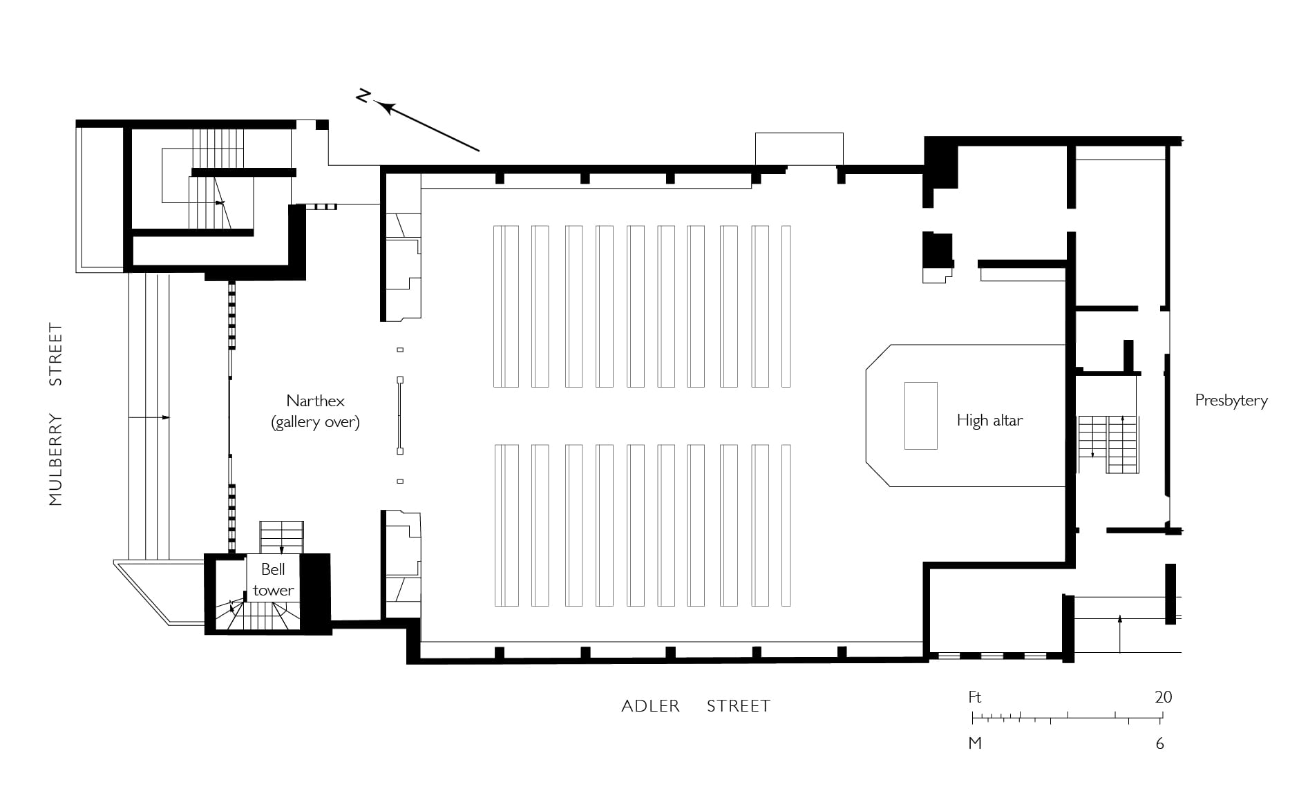
German Roman Catholic Church of St Boniface, Mulberry Street, Whitechapel, in 2003 (photograph by Jonathan Bailey for English Heritage, © Historic England Archive) and ground plan (drawing by Helen Jones for the Survey of London)

The church has a concrete encased steel portal-frame structure. The main walls are of hand-made dark-brown bricks rising to a clerestorey. Above, concrete eaves, cast (unusually) on plastic-lined shuttering for a coffered effect, underlie a copper roof that was supplied by the Ruberoid Co. Ltd. The upper-storey of a Westwerk is faced with small coloured-glass windows in a grid of black mosaic crosses on a yellow ground. The south-west tower rises 130ft and is clad with concrete slabs faced with grey-scale patterning in ceramic mosaics. At its top an open belfry houses the salvaged locally made Victorian bells. This slender and prominent landmark tower was chosen in an either-or situation in preference to central heating, toilets and a vestry room, prestige trumping comfort. The building as a whole is remarkable for the richness, originality and elegance of its decoration. The plain three-storey presbytery to the south facing Adler Street, habitable by 1962, contrasts with ochre two-inch bricks.

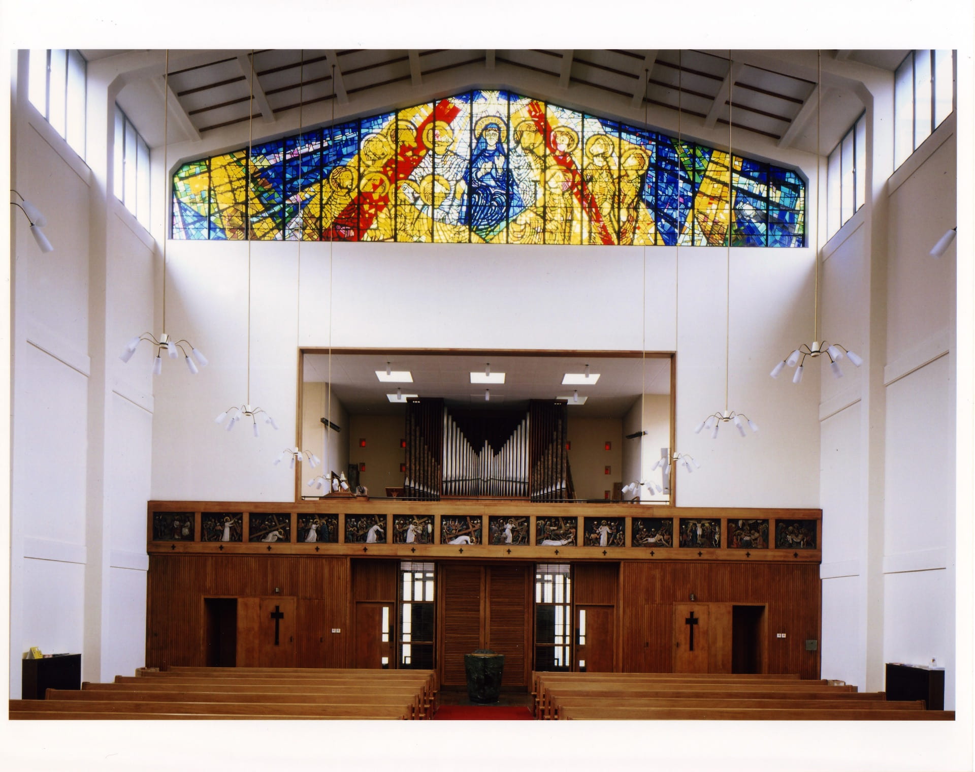
German Roman Catholic Church of St Boniface, interior views in 2003, showing the south (liturgical east) end (top), and north (liturgical west) end (bottom) (photographs by Jonathan Bailey for English Heritage, © Historic England Archive)

The church interior is spacious and light, generally white in its surfaces setting off fittings and stained glass of distinction. Within a timber-lined narthex, it provided seatings for 200 in the nave and sixty in a north gallery. The high altar, Lady Altar, tabernacle plinth, and a quasi-triangular font are all of a dark green marble, with a chancel floor of white Sicilian marble, enlarged after the Second Vatican Council of 1962–5. On the south (liturgical east) wall there is a large sgrafitto mural of Christ in Glory above St Boniface preaching to the faithful, made by Heribert Reul of Kevelaer, which is near Cleves. Figurative and decorative wrought iron is by Reginald Lloyd of Bideford, Devon – four panels (altar rails resited as a kind of reredos in the post-Vatican II reordering of the sanctuary) and a gallery front depicting the Crucifixion with the Nativity and the Resurrection. An ambo or pulpit front depicting the parable of the sower has been removed since 2003. There is a lectern of 1980, made by Lloyd to mark the thirteenth centenary of St Boniface’s birth in Devon. The font has a bronze cover commemorating Simml (d. 1976), also by Reul. To the north (liturgical west) the gallery front has the Stations of the Cross, relief carvings from Oberammergau (by Georg Lang selig Erben), eleven of fourteen dating from 1912 and reused from the old church. Romanus Seifert & Sohn made the organ in 1965. A spectacular stained-glass window by Lloyd above the gallery depicts Pentecost. The congregation began to disperse and dwindle and since the 1970s the church has been shared with a Maltese community.

1 – The Builder, 4 October 1862, p. 713

2 – Morning Herald, 20 April 1786

3 – Felix Leushacke, ‘Memorandum über Damalige Umstände beim Wiederaufbau des Anwesens der deutschen katholischen Mission in den Jahren 1958/60 für St Bonifatius-Kirche und Pfarrhaus und 1968/70 für das Gemeindezentrum Wynfrid-Haus in London Whitechapel’, 1993, typescript held in the parish archive at the Church of St Boniface, p. 3

Central House and 1–13 Adler Street: flatted factories in Whitechapel

By Survey of London, on 24 July 2020

Central House on the south side of Whitechapel High Street is in the middle of a transformation, not its first.

Central House in July 2020 prior to the addition of extra storeys, view from the north-west (Survey of London)

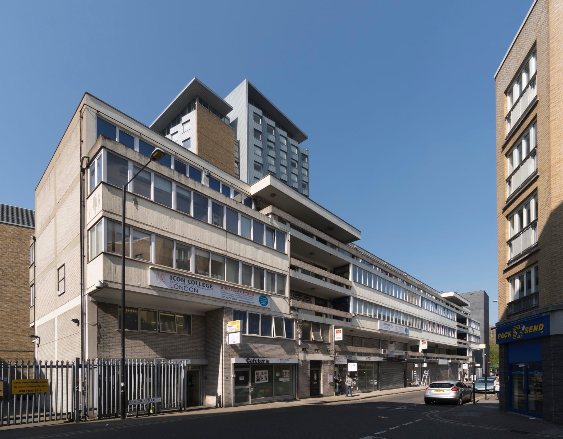
The building began as a flatted factory, that is rentable spaces for small-scale industry, an important aspect of post-war reconstruction and planning in east London. Another roughly contemporary flatted factory survives close by, on the west side of Adler Street. This post presents both these buildings of the early 1960s, also accounting for what has happened to them since.

Central House, Whitechapel High Street, 1964–5, Lush & Lester, architects, view from the north-east in 2016 (photographed by Derek Kendall for the Survey of London)

1–13 Adler Street, 1963–4, Yorke, Rosenberg & Mardall, architects, view from the south-east in 2017 (photographed by Derek Kendall for the Survey of London)

The County of London Plan of 1943 prescribed distinct zones of activity, recommending the dispersal of industry away from London’s inner boroughs. It was recognised, however, that small factories and workshops, heretofore scattered hither and thither, could not realistically be banished but would need in some degree to be kept close to the housing of those they employed, preferably gathered together in low-rent premises.

The plan therefore recommended the building of flatted or ‘unit’ factories, ‘which have proved suitable for clothing, some types of light engineering, light chemicals and chemists’ preparations, and furniture, although the latter will require more room for saw benches.’ [1] In keeping with this the Stepney–Poplar Reconstruction Scheme of the late 1940s envisaged an industrial enclave to either side of Plumbers Row, a heavily bombed area that extended west to Adler Street. Denys Munby presented formidable evidence in favour of industrial relocation in Industry and Planning in Stepney: A Report presented to the Stepney Reconstruction Group (1951). But, having investigated multi-storey flatted factories, the LCC reaffirmed their desirability in East London in 1954 as redevelopment began to swing into action. A Unit Factories programme was begun and an exemplar followed at Long Street in Haggerston in 1958–9. Further support for this approach to keeping employment local had come from Michael Young and Peter Willmott in Family and Kinship in East London (1957).

Compulsory purchase and other difficulties meant that Walter Bor, the planner–architect in charge of redevelopment in Stepney in the LCC Architects’ Department’s Town Planning Division, had to revisit plans for the Plumbers Row area in 1959 to accept mixed use before he had worked up a scheme for unit factories/workshops. He turned to another site on the west side of Adler Street (beyond the zone), where houses of the 1780s flattened in the war had been cleared. Alternatives for a two-storey building were prepared and revised and in 1961 Yorke, Rosenberg & Mardall were engaged to see the job through. They prepared a scheme for a five-storey block to house fifteen units of from 600 to 2,200 square feet for light industry or wholesale showrooms above seven ground-floor shops, with access galleries off two stair and lift landings to permit subdivision. A specification for fair-faced concrete finish of the highest standard was questioned but approved as being of ‘architectural importance’. When tenders came in too high, the architects were obliged to reduce the estimate of £124,520 by £22,000. In the event the contract went to William Willett (Contractors) Ltd in 1963 for £110,430 and the building was completed in 1964. Early tenants were mostly in the rag trade, largely tailors.

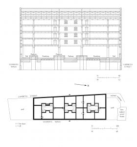
1–13 Adler Street as built in 1963–4 (drawn by Helen Jones for the Survey of London)

Built with a reinforced-concrete frame and grey-brick infill panels on a regular grid, the Adler Street building has cantilevering that with its recessed galleries gives the long elevations dramatic Modernist geometry of the kind to which the term Brutalist is now often applied. Much of the fair-faced concrete has been painted, rougher aggregate staying exposed on the gallery rails. Parts of the building have been adapted for educational use, the second and third floors unified for the Icon College of Technology and Management London.

1–13 Adler Street, view from the north in 2017 (photographed by Derek Kendall for the Survey of London)

Meanwhile, close by to the west, planning for the roadworks that were to create the Gardiner’s Corner gyratory system meandered through the 1950s. The intended rerouting of the end of Commercial Road precipitated the compulsory purchase of a site on the south side of Whitechapel High Street that had for many decades housed Davis’s Feather Mill. In 1959 Lush & Lester, architects, a partnership formed in 1956 by Cecil Lush and Alfred Lester, approached the LCC to propose an eight-storey building on what would remain of this site, suggesting warehouses and showrooms below a flatted factory. This fitted well with the LCC’s approach to Stepney’s comprehensive development and was favourably received.

Reduced to six storeys, Lush & Lester’s scheme was granted planning permission in 1961. Central & District Properties Ltd of Berkeley Square secured a 99-year lease from the LCC and carried forward the development, starting with site clearance in 1963. Central House went up between June 1964 and June 1965. Taylor, Whalley & Spyra were the engineers, responsible for precast-concrete panels, and Tersons Ltd the contractors.

Lush & Lester responded to the challenge of building cheaply and sturdily with a pragmatism that was characteristic of their work. Central House has a simple reinforced-concrete frame of six bays east–west and ten bays north–south. Continuous windows wrap around all sides of the building. On the short north and south elevations, off-centre open staircases are recessed above projecting balconies over entrances for access to the workshops on the second to fifth floors. Seven ground-floor showrooms were given corresponding first-floor warehouses or workshops. An eastern service lane off Manningtree Street snakes around a semi-circular substation to underground parking. The ground and first floors were immediately occupied by textile businesses, but other intentions were diverted. The Sir John Cass School of Art was accepted as the main tenant of the rest of the building. Modular partitions made it readily adaptable to educational purposes, but the logic of the flatted factory was lost.

Central House, view from the north in 2016 (photographed by Derek Kendall for the Survey of London)

In 1978 Roy Sandhu, a lower-storey tenant through Roy Manufacturing Co. (Fashion) Ltd, acquired the Central House freehold. With the rag trade on the wane, in 1986 Sandhu turned to property development. He commissioned Ian Ritchie, a Wapping-based architect, to reimagine a site that stretched from Commercial Road to St Mary’s Gardens (Altab Ali Park), taking in Central House and involving the closure of White Church Lane. The speculative scheme tested the appetite for a monolithic banking centre just east of the City, presenting a potential rival to Canary Wharf.

The proposal consisted of a semi-cylindrical office tower of sixty storeys, taller than any tower in Europe at the time, inflected with High-Tech nuance. Dealing floors clad in translucent glass were to be punctuated by open garden levels at strategic intervals. A four-storey mixed-use podium was a concession to the urban context, so too was new parkland behind the tower, envisioned to extend and upgrade St Mary’s Gardens. Sandhu’s project was widely reported, at least in part on account of his rags-to-riches story and bold ambition. Roy’s Corner, as the scheme was mockingly dubbed, was not well received by Tower Hamlets Council and local residents. Criticism focused on the tower’s high proportion of office space, its potential impact on the rag trade, and its unprecedented scale. An unfavourable political climate ensured the controversial scheme was shelved. Even so, it was resurrected in 1988 with only a slight reduction in height. It failed once more, though Ritchie claimed, to the incredulity of critics but with some foresight, that ‘the tower will be hardly visible from street level until you look upwards and then it will be like gazing into the 21st century.’ [2]

Via a series of mergers, the Sir John Cass School of Art was subsumed into London Metropolitan University (LMU) in 2002. Central House had been retained throughout, used for teaching art, craft and design since the 1960s, with additional workshops at what had been the London College of Furniture to the east on Commercial Road. In 2011 the University moved its Architecture Department from Holloway Road premises to Central House to create a unified ‘creative hub’. All floors of the building came into the possession of the Faculty of Art, Design and Architecture and a thorough refurbishment was undertaken by Cartwright Pickard, architects. Reorganization of the ground floor and basement created new entrance, gallery, café, gym and studio spaces.

Robert Mull, LMU’s Director of Architecture and Dean of the Cass Faculty, commissioned insiders Florian Beigel, Philip Christou and the Architecture Research Unit (ARU), to re-conceive the upper floors of the building to facilitate the teaching of architecture. Their scheme reasserted the original structure, but deliberately sought to disrupt its pragmatism to allow informal connections between disciplines to emerge serendipitously. After relocating to Central House in 2013, students and staff acknowledged the efficacy of Beigel, Christou and the ARU’s sensitive interventions. Moreover, the ‘Aldgate Bauhaus’ benefited from proximity to the East End art scene and the Whitechapel Gallery. Confidence in the future culminated in July 2015 in a proposal for a large installation of external signage designed by art Professor Bob and Roberta Smith. It was to proclaim ‘Art Makes People Powerful’. Subsequent events suggested otherwise.

Central House, view along the north front in 2016 (photographed by Derek Kendall for the Survey of London)

In October 2015, under heavy financial pressures, LMU’s management presented a ‘one campus, one community’ plan, anticipating the closure of nineteen courses and a much-reduced student body. Central House was designated for sale and the Cass was to be relocated to Holloway Road, its new custom-designed teaching spaces discarded. The proposed closure was met with fierce opposition, perceived to be a short-sighted commercial decision, and indicative of an identity crisis afflicting former polytechnics. A ‘Save the Cass’ campaign drew widespread support, including from David Chipperfield, Richard Rogers and Nicholas Serota. The sale of Central House was debated in the House of Lords, but the government declined to take action and LMU’s management kept its resolve.

In February 2016 Frasers Property purchased Central House from LMU for £50m, a price the University noted was ‘significantly above the expected market level’. [3] The Cass vacated on 31 August 2017, relocating to Calcutta House off the north side of Whitechapel High Street. Initial plans for a retail, hotel and office tower of around thirty storeys, with outline designs prepared by Arney Fender Katsalidis, were scaled back in 2018 in favour of an office-block scheme by Allford Hall Monaghan Morris. This was approved and is being carried forward by BAM Consruction. It retains the north, south and west walls of Central House and adds six storeys in somewhat mirroring form, though in steel and darker hued, a parti that claims inspiration from Rachel Whiteread’s Fourth Plinth.

1 – J. H. Forshaw and Patrick Abercrombie, County of London Plan, 1943, pp. 97–8

2 – East London Advertiser, 6 August 1988

3 – Building Design, 23 February 2016

The Tilbury Shelter

By the Survey of London, on 17 April 2020

During the Blitz in 1940–1 a Whitechapel building, the Commercial Road Goods Depot, housed the East End’s single biggest bomb shelter. The history of what was known as the Tilbury Shelter seems timely, if only as a reminder of how different that crisis was from the one we are presently living through. What follows is based on research and text prepared for the Survey of London by Rebecca Preston. We would like also to acknowledge help from Robert Thorne, Tim Smith and Peter Kay.


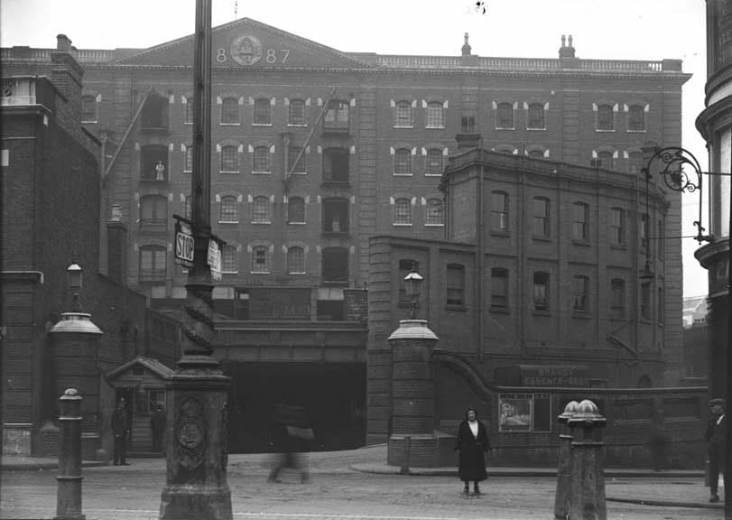
Commercial Road Goods Depot from the north, c.1905 (© Museum of London/PLA Collection)

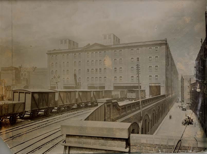
Commercial Road Goods Depot from the south, c.1905 (© Museum of London/PLA Collection)

The Commercial Road Goods Depot was a behemoth of a building that extended from the Commercial Road near its west end as far south as the viaduct of the London and Blackwall Railway, beside Cable Street. It was built in 1884–7 by the London, Tilbury and Southend Railway Company as a receiving and forwarding depot for merchandise dealt with at the East and West India Dock Company’s Tilbury Docks, which opened in 1886. The premises comprised ground-level vaults with viaduct-level sidings, a shunting yard and a branch line, and a goods station below the colossal warehouse. It was all demolished in 1975.

Commercial Road Goods Depot, plans at street-level (left) and upper rail-level (right) (drawn by Helen Jones for the Survey of London based on drawings by Tim Smith)

The London, Tilbury and Southend became part of the London, Midland and Scottish Railway Company (LMS) in 1923 as part of the ‘grouping’ or reorganisation imposed on private railway companies following the experience of government-run railways during the First World War. The lower levels of the Commercial Road goods depot served as general stores. The warehouse above was bonded and used by the Port of London Authority (PLA), the public trust that succeeded London’s private dock companies in 1909, as vast tea stores containing 78,000 chests.

Bulking tea for the PLA in the Commercial Road warehouse (from William Ukers, All About Tea, 1935)

In April 1940 the LMS agreed to the use of the Commercial Road Goods Depot as an air-raid shelter, provided Stepney Borough Council scheduled sufficient wardens to work under the company’s police, and that notices prohibiting smoking were put up in English and Yiddish. Initially the plan, probably a temporary measure, was to create two adjoining shelters, one for LMS personnel and a second ‘PLA Shelter’, above, for 1,400 members of the public. There were fears that ‘people caught in the streets would rush for this shelter as they did during the last war’.1 In preparation, the PLA’s engineers, Rendel, Palmer & Tritton, oversaw the bricking up of lower windows. However, when Stepney Council proposed using both the PLA and LMS sections as an official public air-raid shelter, the lower LMS section was refused approval by the Ministry of Home Security because it would involve ‘dangerously large concentrations of people in one shelter and because the Railway Company insisted that the roadway through the LMS sections be kept open for traffic’.2

Commercial Road Goods Depot, cross section looking south and typical warehouse floor plan (drawn by Helen Jones for the Survey of London based on drawings by Tim Smith)

The LMS Chief Engineer, R. C. Cox, noted that should the building be hit by a large bomb there was ‘a rather large calamity factor’, but that this was a necessary risk in the absence of other shelters in the area. In early September 1940, when the night raids of the Blitz began, the London Civil Division Region Officer told the Stepney Air Raid Precautions (ARP) Controller that ‘we must face facts as they are: this is not a public shelter but large numbers of people are using it as such and we cannot keep them out in present circumstances’.3 The LMS Goods Manager then agreed that about two-fifths of the low-level depot, the northern parts, could be used as a shelter under Stepney’s auspices with police protection, especially at Hooper Street, to keep out crowds.

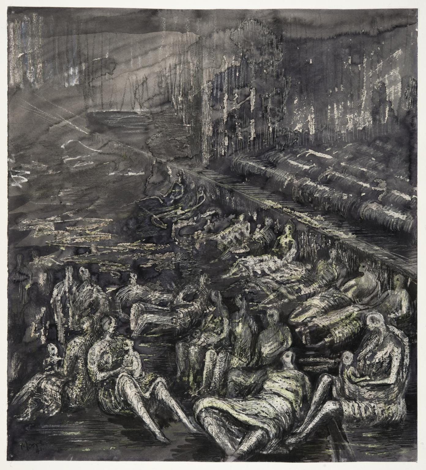
The public, however, took possession of both the official (PLA) and unofficial (LMS) parts, thereby creating London’s largest air-raid shelter, which quickly became known as the Tilbury Shelter. Stepney was told that it must accept the situation and install sanitation. Works undertaken through Rendel, Palmer & Tritton were held up by labour shortages and were not complete in the official shelter until at least December. They eventually included bunks, lights, WCs, canteen facilities and medical supervision. When a head count was first taken in October 1940, some 8,000 people were found across both sections of the shelter. It was reported that on most nights the shelter held 14,000, thronging on a rainy night to form a ‘grim haven of 16,000’.4 There might have been exaggeration, but even so, in December official sources counted 4,244 people sheltering in the unofficial (LMS) lower-depot section, which remained ‘bare of amenities except hessian screened chemical closets’.5

Henry Moore, ‘A Tilbury Shelter Scene’, 1941 (© Tate Gallery, presented by the War Artists Advisory Committee, 1946, http://www.tate.org.uk/art/work/N05708, CC-BY-NC-ND)

This unofficial shelter was managed internally by the Communist Tilbury Shelter Committee, the leading organisers of which in its early years appear to have been its Secretary, a Mr Neidle, and Miss M. Ackerman, the Honorary Secretary, who gave her address as 153f Back Church Lane. To the PLA Police, which held jurisdiction at the Tilbury Shelter, the mass of people in the unofficial section in particular presented the threat of unrest whipped up by political agitators. The social research organisation, Mass Observation, sent observers to report on life in the shelter, ‘to make a complete study of the sociology of the largest underground concentration of humans yet known’.6 It noted that the efforts of the PLA Police to prevent the sale of the Daily Worker were usually outwitted by the occupants, ‘by no means all of whom are Communist sympathisers’, on freedom-of-speech grounds.7

Edward Ardizzone, ‘Shelter Scenes’, 1941 (Imperial War Museum, Art.IWM ART LD 1091.  © IWM. Original Source: http://www.iwm.org.uk/collections/item/object/497)

Bunks were installed in 120 triple tiers in the PLA or warehouse section of the Tilbury Shelter in late October 1940. Within a month the vaults of the unofficial LMS or goods depot section had also been ‘fully bunked’.8 Nina Hibben, a Mass Observation worker, recorded that ‘The first time I went there, I had to come out, I felt sick. You just couldn’t see anything, you could smell the fug, the overwhelming stench … there were thousands and thousands of people lying head to toe, all along the bays and with no facilities … the place was a hell hole, it was an outrage that people had to live in these conditions’.9 Despite such accounts, it seems that a kind of order prevailed as necessary routines were established. Life in the cavernous interiors of the Tilbury Shelter was depicted by Henry Moore, as an official war artist, by Edward Ardizzone and Feliks Topolski, as Civil Defence artists, and by Rose Henriques, a local resident and philanthropist.

Rose Henriques, ‘Sleepers’, Tilbury Shelter, 1940 (© Museum of London)

Both sections of the Tilbury Shelter were ticketed and monitored by the police, the official part accessed from Commercial Road and the unofficial part, now cut off by a brick wall, from Hooper Street. Closure of the unauthorised part of the warehouse, if tickets for other shelters were provided, was pursued and resisted in early 1941. Colin Penn, an architect with Communist sympathies, appears to have been to the fore among five architects from the Association of Architects, Surveyors and Technical Assistants who compared the Tilbury Shelter with alternative accommodation. On finding that the majority was less safe than the unofficial LMS section, the architects refused to recommend dispersal and occupants broke down the dividing wall. The police prevented a subsequent meeting, at which the architects were due to speak, called in protest against the eviction of the remaining occupants, which now numbered between 1,200 and 4,200 depending on the severity of raids. Public resistance to evictions and closure of the unofficial shelter continued. By May 1941, however, after the last major attacks of the Blitz, the unofficial sections were ‘not of course used at all now’ and were soon taken over as an official shelter in readiness for further bombing.10

There were still rumblings of discontent during 1942 and 1943, when low numbers of occupants were recorded. Eleanor Roosevelt visited the Tilbury Shelter with King George VI in October 1942. Other interventions were made by Rear-Admiral the Rev. A. R. W. Woods, Chaplain of the Red Ensign Club (sailors’ hostel) on Dock Street. In November 1944, a deputation from the Hindustani Markaz (Indian Centre), 14 White Church Lane, was received by the Ministry for Home Security, the Stepney ARP Controller and the High Commissioner for India. It complained of offensive behaviour, that officials had on numerous occasions insulted members of the local Indian community in the shelter or prevented their entry on racist grounds.

Commercial Road Goods Depot from the south-west c.1970 (photograph by Dan Cruickshank)

Meanwhile the warehouse had itself been bombed. In early November 1940 a direct hit destroyed practically all of the roof and much of the top floor. This caused the PLA to wind up use of the building as a tea warehouse. Part of the warehouse was taken over by the Ministry of Supply and the US Army, which formed a large canteen at the north end. By 1946 the US Army had left, the Ministry of Supply was storing ‘portable house’ or Prefab parts, and the PLA had returned with tea. The vaults and ground floor once again became an LMS goods depot. The depot ceased operations in 1967 and demolition followed in 1975. The site was redeveloped for the National Westminster Bank as a computer centre. In recent years it has once again been redeveloped with tall blocks of housing.

Former Commercial Road Goods Depot hydraulic pumping station, Hooper Street, view from the west in 2019 (photographed for the Survey of London by Derek Kendall)

The only substantial surviving reminder of the railway goods-handling complex is its former hydraulic pumping station on Hooper Street, which was converted to office use in 2002–4.

1 – The National Archives (TNA), HO207/860

2 – Ibid

3 – Ibid

4 – Illustrated, 5 October 1940, p. 14

5 – TNA, HO207/860

6 – University of Sussex Special Collections, Mass Observation Archive, 486, Sixth Weekly Report for Home Intelligence, November 1940

7 – University of Sussex Special Collections, Mass Observation Archive, 431, Survey of Voluntary and Official Bodies during Bombing of the East End (RF/NM), September 1940

8 – TNA, HO207/860

9 – As quoted in Gavin Weightman and Steve Humphries, with Joanna Mack and John Taylor, in The Making of Modern London, 1983 (2007 edition), p. 260

10 – TNA, HO207/860

Memory Map of the Jewish East End

By the Survey of London, on 30 March 2020

We hope this finds our readership well. We intend to continue to publish posts on the Survey’s blog through these extraordinary times. We are still able to work from our respective isolations, and feel that short reads about aspects of London’s history are likely to be more than usually welcome diversions. An unfortunate consequence of our new circumstances is that, as has been the case everywhere, we have had to cancel events, including two launches, one of a website that was to have taken place at Sandys Row Synagogue on 29 March, another of a book, volume 53 in the Survey’s main series, about Oxford Street, that was to have happened at the London College of Fashion on 20 April. Our continuing posts will start with accounts of those two projects, the website first, then the book.

In collaboration with the artist and writer Rachel Lichtenstein, the Bartlett’s Centre for Advanced Spatial Analysis, the Space Syntax Laboratory and the Survey of London have together created a new website. It is a ‘Memory Map of the Jewish East End’.

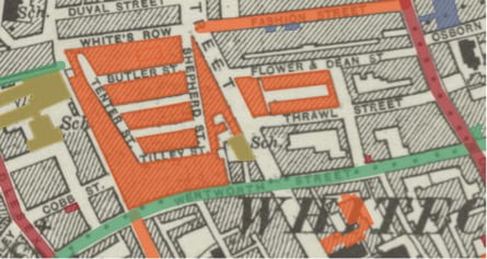
The Memory Map of the Jewish East End Historic Map CC-By-4.0. Reproduced with the permission of the National Library of Scotland

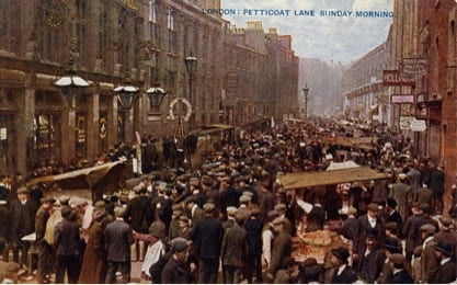
By 1900 the East End was home to over 100,000 Jewish people, most had recently arrived as refugees from Russia and eastern Europe. They settled predominantly in Whitechapel and Spitalfields, the heart of a thriving Jewish quarter, joining an already established community of Jewish migrants from Holland, Germany and other places. By the outbreak of the Second World War, the Jewish population in the area had already started to dwindle. Today very few tangible traces of Jewish East London are left —the kosher shops and restaurants, social and political establishments, synagogues and theatres have nearly all disappeared. The Jewish East End is on the verge of slipping from living memory.

Postcard showing Petticoat Lane market in the early twentieth century

The new website is an interactive ‘Memory Map’ allowing visitors to explore the social and cultural history of the Jewish community in east London. Rachel Lichtenstein’s substantial archive of audio interviews with former and current Jewish residents of East London is brought together with new and archival photographs, material from the Survey of London’s recent work in Whitechapel and other original research, some previously unpublished. Covering more than seventy significant sites, the website aims to become a lasting document of the history and memory traces of the former Jewish East End and to bring the stories, memories, voices and images of this vanishing landscape to new audiences.

Dedicatory plaque on the King Edward VII Memorial Drinking Fountain on Whitechapel Road. Photographed in 2016 by Derek Kendall for the Survey of London

Metal relief sign made for the Jewish Daily Post by Arthur Szyk in 1935 on 88 Whitechapel High Street. Photographed in 2016 by Derek Kendall for the Survey of London

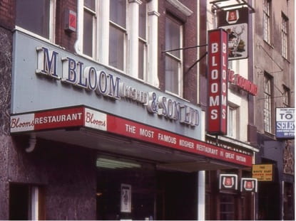
Bloom’s Restaurant, 90 Whitechapel High Street, 1977. Copyright Shloimy Alman

To begin exploring the map, visit https://jewisheastendmemorymap.org/.

A detail from the Memory Map – the Soup Kitchen for the Jewish Poor, 9 Brune Street, Spitalfields


The Gunmakers’ Company’s Proof House complex, 46–50 Commercial Road, Whitechapel

By the Survey of London, on 21 February 2020

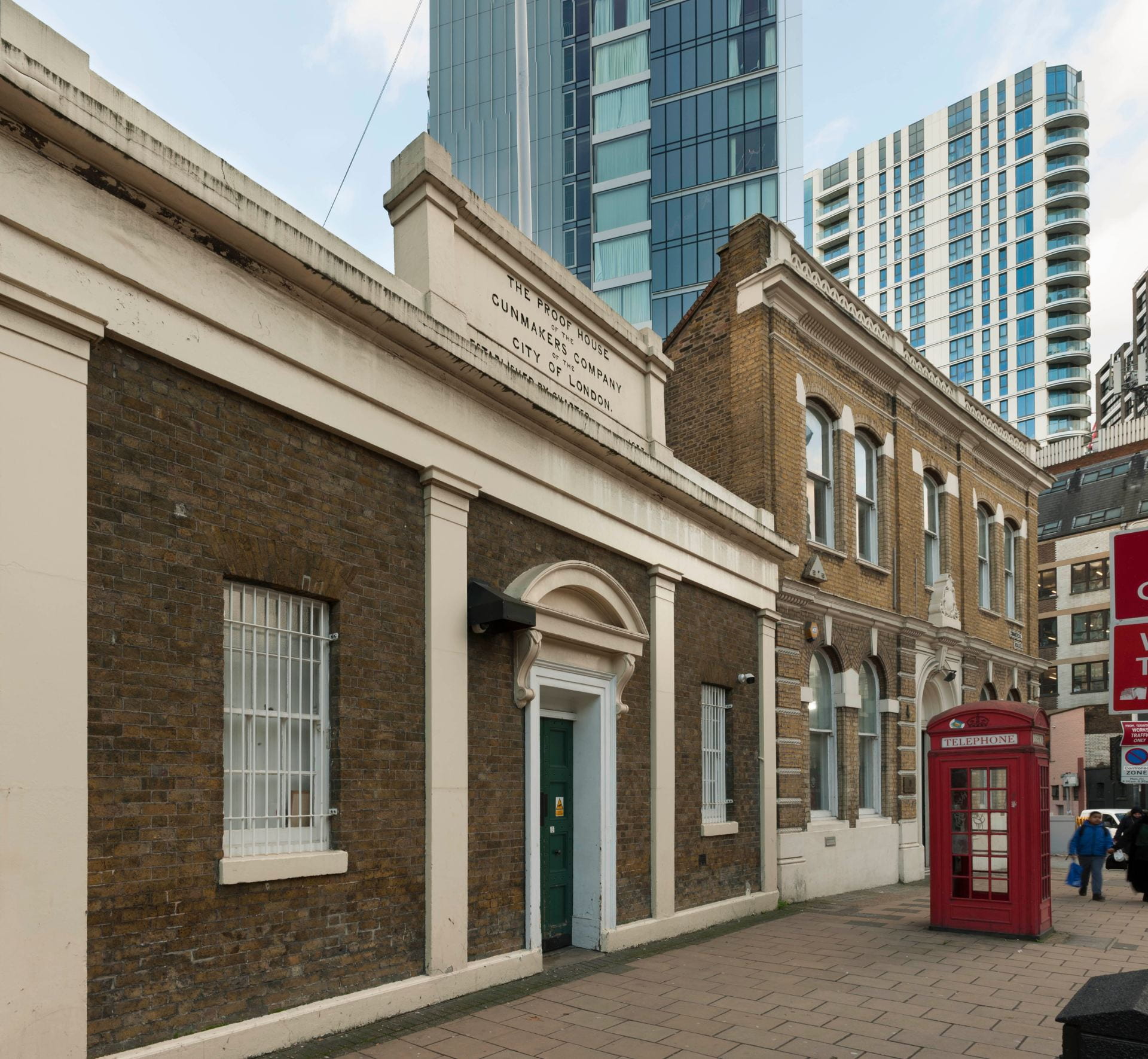
An irregular group of buildings on the south side of Commercial Road near its west end is a unique survival. Here a City Livery Company continues to exercise an original regulatory function on a site it has occupied for nearly 350 years. The buildings are the Gunmakers’ Company’s proof master’s house, proof house and receiving house (alternatively shop, office or room), all largely of the 1820s, and, to the west, the Company’s former Livery Hall, built in 1871, possibly incorporating earlier fabric from an East India Company storehouse of 1808.

The Gunmakers’ Company’s Proof House complex, showing the former receiving house and Gunmakers’ Hall, 46–48 Commercial Road, view from the north-east. Photographed in 2018 by Derek Kendall for the Survey of London

The Worshipful Company of Gunmakers was instituted by charter in 1637, nearly fifty years after a group of gunmakers drew up draft procedures for proving the safety of firearms. Opposition from other interested parties – the Blacksmiths and Armourers – delayed the creation and adoption of the Company until a Royal Commission of 1631 recommended its institution. It received its charter from Charles I, but the proving of guns did not start until the charter was enrolled in 1656. This enabled the Company to test all new hand guns, great and small, pistols and daggs (heavy pistols), produced in London and for ten miles around, or imported, to search for the same, and to ensure that gunmakers had served a seven-year apprenticeship and produced a proof piece to the satisfaction of the Company. The Company’s first proof house, for testing the security of gun barrels by subjecting them to firing loads a quarter to a third heavier than normal, was built in 1657 near Aldgate on land owned by John Silke, a gunmaker. An explosion that damaged Silke’s premises may have encouraged the Company to take a new site in 1663, probably in the Minories or East Smithfield, the centre of the London gunmaking industry.

In 1676 the Company moved to its current site. This appealed, no doubt, because it was then in an open field and had no neighbours to disturb or damage. The site formed part of a larger holding bounded north and east by Church Lane, west by Goodman’s Fields, and extending south as far as present-day Hooper Street. This property was held in 1691 by John Nicoll, probably a Holborn soapmaker who had a family connection with Whitechapel through the Darnelly family, and from 1692 to 1703 by John Skinner, an apothecary with property in Whitechapel High Street. Skinner’s profession may account for the land being denominated the Physick Garden, though the name Jackson’s Garden was also in use. Skinner sold the entire property freehold in 1703 to Benjamin Masters, a mariner, and part was leased to Jonathan Keeling, a gardener, in 1720.

The Gunmakers’ site was at the north-west corner of the Physick Garden. It was an irregular rectangle of ground, approximately 85ft wide by 58ft deep, bounded north by a ‘mudd wall’ and ‘a passage made by and through the mud wall’, west by a ditch and a ropewalk, east by ‘the hedge next to the dung road’,1 and south by another ditch separating it from the rest of Masters’ land. The proof house of 1676 was built by Michael Pratt, a carpenter, who held a lease on the ground.

That proof house had to be rebuilt in 1713, this done by one John Rogers on a new sixty-one-year lease from Masters. Thereafter the Gunmakers acquired the freehold of the site. A proof master’s house was present by 1733 when the master, Humphrey Pickfatt, was taxed for the proof house and a dwelling.

Ground plans of the Gunmakers’ Company’s Whitechapel complex in 1752 (top) and in 1920. Drawing by Helen Jones for the Survey of London

In 1752 a boundary dispute arose with Sir Samuel Gower, who had become the freeholder of land adjoining to the south and west. A plan accompanying the agreement that resolved this dispute reveals that the Gunmakers’ site did not extend eastwards quite to what had become Gower’s Walk, from which it was separated by a long 10ft-wide strip of land, occupied by a greengrocer’s shop with a small house behind. At this stage the Gunmakers’ premises included the proof house, roughly 20ft square, to the east adjoining the greengrocer’s, a privy at the south-east corner of the yard, the 35ft-wide (so double fronted) proof master’s house to the west (on the site of No. 46), the charging house (for charging weapons prior to proof), a shallow building about 20ft wide on Church Lane, with a smaller marking room (for stamping proofed weapons with the Gunmakers’ proof mark) on its east side abutting a narrow yard intruding into the greengrocer’s site on the Gower’s Walk corner.

Datestone on the back wall of the former receiving house. Photographed in 2019 by Derek Kendall for the Survey of London

Thus lay the Gunmakers shortly before a major rebuilding, prompted because the proof house was once again ‘ruinous’. It was reconstructed in 1757–8 ‘on a more beneficial and useful plan’,2 with the proof master’s house adjoining. A date-stone survives, reset on an inner wall of the receiving house (see above). In 1760 the charging house, marking house and counting house, also ‘ruinous’, were rebuilt on the same sites.3 Contention arose in 1781 when Joel Johnson and others complained that the proof house damaged their investment in houses they had built nearby on Gower’s Walk, but the Gunmakers reasonably pointed out that the proof house had been in that location for more than a hundred years, builders must have been aware of this before they chose to build nearby. Further additions and improvements were made, though Johnson refused to sell the easterly strip of land he then held.

Further development happened on the establishment’s west side in the early nineteenth century. The East India Company had been acquiring arms from London gunmakers since 1664. From 1709 to 1766 and again from 1778 it used the Gunmakers’ Company’s facilities to prove its arms. The East India Company built a storehouse and inspection room in 1807–8 on a westerly strip of the Gunmakers’ site, of which it took a ninety-nine-year lease in 1815. A door gave access to the Gunmakers’ yard through which barrels were transferred to the proof house. Beyond, the westernmost end of the Gunmakers’ holding was also developed, with two street-side houses with rear workshops, built in 1812 by John Williams, a bricklayer, on a fifty-seven-year lease. These properties were occupied over the next thirty years by a hairdresser, a bootmaker and a watchmaker, and were together gradually taken over by George Story (1805–1874), a scale-maker and the leaseholder from 1839.

By 1823 the proof house was again dilapidated, and the master’s house ‘likely to endanger the lives of the proof master and his family’.4 Hereafter the site was rearranged much as it is today. The freehold of the easterly strip of land between the proof house and Gower’s Walk was acquired from George Waller, more amenable to a sale than his father-in-law, Joel Johnson. The new proof house and proof master’s house were built in 1826–7 at the north-east corner of the enlarged site, with a single-storey and basement receiving or entrance building adjoining to the west. These buildings were designed by the Company’s surveyor, Robert Turner Cotton (1773–1850), perhaps with input from his son, Henry Charles Cotton (1804–73). John Hill was the bricklayer, and James Bridger of Aldgate the carpenter. Foundations for the proof house, dug and redug, were five bricks thick and more than 12ft deep.

The Gunmakers’ Company’s proof house, Gower’s Walk, view from the south-east in 2015. Photographed by the Survey of London

The proof house itself, up against Gower’s Walk behind the proof master’s house, is outwardly entirely utilitarian, a rectangular stock-brick building with segmental-headed windows at upper levels, of a height necessary to cope with the pressures and gases generated by proving. Most of the windows are blind, though some at least originally had iron louvres to dispel the smoke and pressure. The interior was essentially one space under a cast-iron framed roof, though subdivided in its lower half into two unequal open-topped proving chambers, one the main ‘proof hole’, containing a bed of sand where multiple barrels could be tested at once, the charges set off by a trail of gunpowder. In 1835 the upper part of the proof room was lined with cast-iron plates by Graham & Sons to protect the structure from damage from exploding gun barrels. The original cast-iron roof frame and these plates survived until 1994.

The central bay of the former Gunmakers’ Company’s receiving house of 1826–7. Photographed in 2019 by Derek Kendall for the Survey of London

The proof master’s house on the corner is of conventional three-storeyed design, also in stock brick, with a round-headed ground-floor window, gauged-brick arch heads and a stuccoed door architrave and cornice. The single-storey receiving house, possibly incorporating fabric from the marking house of 1760, originally had a copper-lined gunpowder magazine within its attic. Its three-bay façade, again stock brick but heavily stucco-framed, makes a stronger if entirely conventional classical statement. Four pilasters frame openings, including a central entrance with consoles to a segmental pediment. A rectangular panel atop the entablature announces: ‘THE PROOF HOUSE OF THE GUNMAKERS COMPANY OF THE CITY OF LONDON. ESTABLISHED BY CHARTER ANNO DOMINI 1637’.

By 1857 the East India Company building was unoccupied as small arms for India had come to be supplied by the War Office. The Company surrendered its lease in 1860 and, following a report by the local architect G. H. Simmonds, the building was converted in 1863 to be a committee room for the Gunmakers’ Company. This room seems to have been largely incorporated, rather than rebuilt, when the Gunmakers redeveloped the west side of their property in 1871, extinguishing Story’s lease. Gunmakers’ Hall went up to designs provided by John Jacobs, the builder, but possibly the work of Simmonds. It included the old committee room and a new court room to its west with a new two-storey stock-brick front range in a lumpen Italianate manner. Portland stone dressings, now painted, include an arch-headed central door surround and a pierced cornice balustrade. The impressive panelled court room, with a slightly canted south end, has a bracketed coved ceiling with a central lantern. A heavy court room table was grandly set off on the east wall by a huge trophy of arms, a starburst of more than 1,000 bayonets, military swords, hammers, ramrods etc. In 1893 a further room was created above the committee room, with a staircase inserted at the front of the east side of the entrance lobby, this to designs by W. J. Lambert.

The persistence of the Gunmakers on the increasingly urban site had been challenged since Joel Johnson took issue in 1781. In 1802 the Gunmakers successfully resisted the trustees of the new Commercial Road’s plan to acquire the site, though an Act of Parliament limited the hours of the day when guns could be proved. The Gunmakers succeeded in keeping the site from the Commercial Road trustees once again in 1824, and also saw off further limitation on the hours of proving. In 1882 the London, Tilbury and Southend Railway Company pressed to acquire the site for a vast warehouse that went up to the south, but the Gunmakers had only to relinquish a small strip with sheds. Even so, the south walls of the proof house and court room had to be heavily buttressed following excavations for the railway warehouse’s north yard and extensive vaults.

Gunmakers’ Company’s workshop on the west side of the inner courtyard, view from the north with the inner wall of the proof house visible through the window. Photographed in 2019 by Derek Kendall for the Survey of London

Piecemeal repairs and improvements were made from time to time, mostly reflecting changes in the requirements of proof. The shift from muzzle-loading to breech-loading guns and the consequent need for more complex proving accounted for additions in the yard, a small proof house for testing breech-loading guns in 1866, by when secondary proofing could be conducted with a gun fixed in a frame firing into a bed of sand, and other proving-chamber sheds thereafter. By 1920 low-level viewing shops and proofing rooms snaked around the southern boundary including behind the court room, and a loading shop opened off the receiving room. The Company endured lean years in the 1920s and was obliged to sell Gunmakers’ Hall in 1927, the trophy of arms transferred to the Birmingham Gun Barrel Proof House.

Gunmakers’ Company’s inspection bench in the workshop on the south side of the inner courtyard, with the inner wall of the receiving house visible through the window. Photographed in 2019 by Derek Kendall for the Survey of London

The buyers were Israel Eichenbaum (1874–1935), the owner of a wholesale drapery at 20 Commercial Road, and his son-in-law, Pinkus Segalov (1902–1959), and the building was let to the Order Achei Brith and Shield of Abraham Friendly Society. Jewish friendly societies were similar to other such societies, operating a subscription on which members could call in times of sickness. Mainstream societies sometimes excluded Jews, so specifically Jewish societies came into being from the 1790s. The Order Achei Brith (‘Brethren of the Covenant’), founded in 1894 out of a friendly society founded in 1888, was the first fully to embrace a Masonic character, operating as a Lodge with ceremonies, elaborate regalia and rituals. It merged with the Shield of Abraham Society in 1911 and, in common with other registered friendly societies, was empowered to administer the National Health Insurance Act of that year. It was one of the largest such societies by 1928 when alterations were made by Bovis Ltd to close up the connections between Gunmakers’ Hall and the courtyard of the proof house. The building, now called Absa House, was opened as the Order’s headquarters by Lord Rothschild on 14 October 1928, the consecration conducted by the Chief Rabbi. In 1933 the Order had around 25,000 members. What had been proofing rooms in the yard behind the court room were then rebuilt as an office, reached from a door formed from one of the court room windows. The new room was fully lined in modish vaguely art-deco wooden panelling.

The creation of the welfare state and the loss of the powers bestowed in 1911 reduced the practical need for friendly societies. Meanwhile the Order’s membership dispersed and failed to rejuvenate. By 1948 it was down to around 5,000 members. Amalgamation with the Order Achei Ameth in 1949 formed the United Jewish Friendly Society. From 1955 to 1958 what was now 46 Commercial Road was let to the St Louis Club, a social club, with alterations made by H. J. F. Urquhart, architect, for a restaurant in the former court room, a lounge in the former committee room, and a first-floor billiard room. Thereafter the basement was relet to the Gunmakers for arms storage, with alterations for access through the party wall overseen by Morris de Metz, architect. No. 46 reverted to being offices for the Friendly Society, part let off to Joseph Textiles Ltd, until 1976, shortly before the society’s dissolution in 1979.

To return to the east part of the site, in 1927 the imminent loss of Gunmakers’ Hall caused the Gunmakers’ Company to knock the first-floor rooms of the proof master’s house together to form a new court room, tie-rods being inserted; R. Hewett was the builder. Following war damage, the Company made further alterations in 1952 to designs by Albert Robert Fox, architect, with Wilton & Burgess, builders, to convert the receiving house basement into the court room, the proof master’s house altered back to form a first- and second-floor maisonette. In 1959 glazed timber-framed lean-tos for workshops and rifle storage were added on the south and east sides of the courtyard by Morris de Metz and James Jennings & Son Ltd, builders.

Detail of the inner or west wall of the proof house, showing stone tablets commemorating the rebuilding of 1826 and the refurbishment of 1995. Photographed in 2019 by Derek Kendall for the Survey of London

The only major modernisation of the proof house itself took place in 1993–5 when Thomas & Thomas, surveyors, and E. F. Whitlam, engineers, oversaw works by W. M. Glendinning Ltd, builders. Two floors and a reinforced-concrete ring beam and lateral (spreader) beams were inserted, with a light steel-truss roof replacing late-Georgian cast iron. The extra floors, reached by a new staircase at the north end of the building, allowed for four smaller proofing chambers on the ground floor, equipped with ‘snail-catchers’ to contain the fired bullets, depleting their energy in complex bending lengths of metal tubing, in place of the traditional sandbanks, with ammunition storage, loading rooms, a testing laboratory, gun-mounting room and instrument room on the first floor. The second floor was reserved for storage.

Proof House interior, showing a Lee Enfield rifle set up for proof firing. Photographed in 2019 by Derek Kendall for the Survey of London

The former hall at No. 46 was sold by the United Jewish Friendly Society in 1976 to the Bank of Credit and Commerce International (BCCI), a private bank based in Luxembourg and the Cayman Islands, founded in 1972 and rapidly expanding to become the world’s seventh largest private bank. It closed in 1991 when it was revealed to be a giant money-laundering scheme. The former court room became a banking hall with desks and cashiers, the floor in the canted bay removed to create a double-height space, connecting to the basement by a spiral staircase, with a vast window filling most of the south wall. Six new openings were made on the north and east sides, connecting east to the former committee room, now subdivided into a manager’s office and corridor, and north to the lobby. The one-time first-floor billiard room became a conference room. The architect was Harry S. Fairhurst. After the winding up of BCCI, the Gunmakers’ Company offered the liquidators £80,000 for the building. This was rejected and the building sold at auction for £120,000 to Itzik and Adrienne Robin and Robert and Stephanie Itzcovitz. The Gunmakers finally reacquired the building for £1.1m in 2007. After the departure of BCCI No. 46 was used as a textile showroom until conversion to educational use in 2002, first as an outpost of the City of London College at 71 Whitechapel High Street, and since 2009 as the London College of Christian Revival Church Bible School, founded in South Africa in 1944.

Following the closure of branch proof houses in Manchester and Nottingham in 1996 and 2000, Gunmakers’ Company proofing of military weapons in Whitechapel has increased. By 2008 the proof master’s house was no longer residential, being reserved entirely for offices.

Proof House interior, proofing bay mechanisms. Photographed in 2019 by Derek Kendall for the Survey of London


Display of cartridges in the proving workshops. Photographed in 2019 by Derek Kendall for the Survey of London

A hundred years ago, the Builder observed of the Gunmakers that ‘[t]he history of the Company is devoid of the romantic and historical associations connected with most of the misteries (sic), and is that of a well-organized and managed commercial undertaking, doing much useful work and deriving the necessary income from the fees charged for testing and proving weapons’.5 That still holds true.

References

1.  London Metropolitan Archives (LMA), CLC/L/GI/G/001/MS05231

2.  LMA, CLC/L/GI/G/001/MS05227/001

3.  LMA, CLC/L/GI/G/001/MS05220/009

4.  LMA, CLC/L/GI/G/001/MS05227/001

5.  The Builder, 8 October 1920, pp. 400–1

St George’s German Lutheran Church and Goodman’s Fields

By the Survey of London, on 9 August 2019

St George’s German Lutheran Church on Alie Street is located in an area known as Goodman’s Fields in Whitechapel. Though now associated with the recent Berkeley Homes development to the east of Leman Street, for many centuries ‘Goodman’s Fields’ extended much further west, all the way to Mansell Street. It was named after the Goodman family, who held much of the open pasture land regarded as the ‘fields’ in the late sixteenth century. A hundred years later, under the Leman family, the principal streets – Mansell, Leman, Prescot and Alie Streets, were laid out, and the first proper wave of building development took place.

Second and third waves of development saw these streets and others close to St George’s lined with a mixture of substantial mercantile houses, smaller house-workshops, and large factories. However, industries such as sugar refining and gun making increasingly characterised the area, and, by the middle of the nineteenth century, rows of densely occupied terraced houses were constructed on the last remaining open ground. After population dispersal and extensive bomb damage during the two world wars, Goodman’s Fields suffered a loss of identity and a period of decline, becoming home to many large speculatively built office blocks by the early 1990s. In 2019, the area is undergoing a further transformation, with only a limited proportion of the historical built environment remaining, increasingly overshadowed by tall blocks of flats.

The Survey has prepared a new exhibition centring on buildings local to St George’s German Lutheran Church in Goodman’s Fields. It will be displayed at St George’s on 21st and 22nd September, and thereafter migrate around other Whitechapel venues. This post presents a sample of the exhibition, exploring the history of this quickly changing area.

Alie Street elevation of St George’s German Lutheran Church and associated buildings, from an illustration by Dolfer, 1821. Redrawn by Helen Jones for the Survey of London


St George’s German Lutheran Church

St George’s German Lutheran Church is the oldest surviving German church in Britain. Since the eighteenth century, St George’s has been a haven for thousands of German Protestants seeking economic opportunity and religious asylum in the Whitechapel area. Sugar refining is interwoven with St George’s history, having served as a major economic driver for the German immigrant community. Dederich Beckmann (c.1702–66), a wealthy sugar refiner, was a key founding leader of the church and donated substantially towards its construction. The site of St George’s was purchased in 1762, with construction beginning soon after. Joel Johnson and Company served as builder, possibly also architect, and the chapel was consecrated on 19 May 1763. Before fitting out was complete, the building was enlarged at its north end in 1764–5. The church’s vestry was also built at this time.

The church’s external appearance does not demonstrate any clear German architectural connection, rather it is in keeping with other English Nonconformist chapels of the period. Composed of stock brick, its Alie Street façade is symmetrically arranged and features a central Venetian window flanked by identical doors. Centred above the window is a lunette, perhaps at one time glazed, that now reads ‘Deutsche Lutherische St Georgs Kirche Begründet. 1762’ (St George’s German Lutheran Church. Founded 1762). The church’s slate roofline was initially crowned by a bell turret, clock, and weathervane. This was dismantled in 1934 when rot and woodworm were discovered after several decades of deferred structural maintenance. A plain cross can now be found where there was formerly the clock’s face.

Alie Street elevation of St George’s. Photographed in 2017 by Derek Kendall for the Survey of London

Several sequences of repairs and restoration works resulted in replacement of all the original windows. Little else has been altered externally. However, the present juxtaposition between the simple church and towering neighbouring buildings reflects broader local shifts that have taken place in recent decades. Extensive restoration was undertaken in 2003–4, following the transfer of St George’s to the Historic Chapels Trust in 1999. In 2019, St George’s continues under the care of the Trust in partnership with the Friends of St George’s German Lutheran Church. Together they host talks, tours, concerts, and other public events to connect St George’s to the wider community.

Interior of St George’s, c.1930 (Courtesy of Friends of St George’s)

The arrangement of the sanctuary space reflects the evolutionary process of the church’s use, but also retains its original orientation, laid out in a typical Protestant fashion. Pews and galleries are centred around a main speaking platform, giving liturgical emphasis to preaching and the reading of scripture. This focus became a point of contention when the congregation’s first pastor, Dr Gustavus Anthony Wachsel (c.1735–99) incorporated hymn-singing and other musical performances into the more ‘pious’, word-focused liturgy, earning the chapel the critical nickname ‘St George’s Playhouse’. By 1802, the railed sanctuary had been made smaller, giving congregants closer proximity to the altar, and an organ had been installed. This was replaced by a larger instrument in 1885–6 resulting in the removal of upper galleries, which may have been made superfluous by declining attendances.

Mätzoldzimmer, c.1933 (Courtesy of Friends of St George’s)

In the first few decades of the twentieth century, the St George’s community faced numerous difficulties under the strong and steady leadership of Pastor Georg Mätzold (1862–1930). During the First World War, anti-German sentiment was high, and many congregants returned to Germany or were interned. Despite these challenges, the congregation continued to meet, and following Mätzold’s death, the much-diminished community turned to reviving their religious home. This work included a reorganization of the chapel interior, in which a committee room was made under the south gallery. Dr Julius Rieger commemorated his predecessor by dedicating the room as the Mätzoldzimmer, as it is still known. During and after the Second World War, the congregation not only continued to meet but increased in size as new German refugees entered London’s East End. In the second half of the century, attendances declined. A plan for re-arranging the interior by the architect J. Antony Lewis in 1970 would have removed much of the intact joinery, including the pews and large portions of the galleries. This, however, never came to fruition, allowing the eighteenth-century interior joinery to remain intact. It is a significant survival.

Proposed interior reorganisation by J. Antony Lewis, 1970 (Courtesy of Friends of St George’s)


St George’s Schools

A burial ground east of St George’s church was gradually built over. By 1800, a substantial four-storey parsonage adjoined the church adjacent to which stood a modest clerk’s house, likely constructed when a single-storey school replaced stable and coach-house buildings further east (see the drawn elevation above).

St George’s church foundation included ‘German and English Schools’ from 1765, but an operational school was only formally established in 1805, when the parsonage and clerk’s house were given over for educational use. By 1808 a small school building had been erected, accommodating a mixed class of girls and boys aged seven to fourteen. Pastor Christian Schwabe, who served at St George’s from 1799 to 1843, was instrumental in all this and an experienced teacher. Schwabe moved to Stamford Hill where he established a school for distinguished German families, many of which, with other wealthy German merchants, some involved with sugar refining, supported the new Whitechapel school. Voluntary contributions enabled a proportion of less well-off children to attend on scholarships. The numbers of pupils increased rapidly, and girls were separated from boys after a decade with the girls’ classes moved to the parsonage. Other rooms in the parsonage were given over to a new infants’ school, established in the 1850s.

Watercolour of St George’s Infant School of 1859 (Courtesy of Friends of St George’s)

A two-storey infant school was completed in 1859, funded by W. H. Göschen, a banker who was the son of Goethe’s publisher. Held to be the first of its kind in the city, the school allowed mothers to go out to work during the daytime, ‘an urgent necessity amongst London’s growing German population’. By 1877, 283 children were registered at the infants’ school, and the intake of the junior schools had increased to the extent that the existing accommodation on Alie Street was unsuitable. The whole frontage east of the church was then redeveloped, with E. A. Gruning, himself an immigrant German, being the architect. The most significant benefactor was local sugar baker, James Duncan. The rebuilding was spurred on by the enthusiasm and energy of the Rev. Dr Louis Cappel, minister between 1843 and 1882.

St George’s German and English School. Photographed in 2017 by Derek Kendall for the Survey of London

The elementary school closed in 1917 when Pastor Mätzold was deported to Germany. The lower floors were soon used by tailoring businesses, and the upper storeys let out. By 1949 the infant school was disused. In 1983 St George’s converted the first floor into a student hostel/dormitory and retained the basement as a church hall. Both the schools were wholly converted into residential premises in the 1990s.

17 Leman Street

Opening in 1861, the German Mission Day School replaced an eighteenth-century tenement and family-run bakery. Designed by City architect Edward Ellis, the purpose-built school was one of a handful clustered around Buckle Street and the east end of Alie Street, primarily serving the large local German population. This school was supported by a group of German churches and funded through subscriptions from wealthy German individuals. Its initial aim was to educate the poor children of seamen, and it was in some ways a complement to St George’s Infants’ School. It was well attended, with enrolment reaching 150 within a few years of opening. However, by the end of the nineteenth century many German families had moved out of Whitechapel. This, coupled with the establishment of Board Schools following the Public Schools Act of 1868, led to the school’s closure in 1897 and the building being let out for commercial purposes.

Entrance to 17 Leman Street (now demolished). Photographed in 2007 by Danny McLaughlin

By 1903, the former Mission School was in use by the Jewish Working Girls’ Club (JWGC), which began in 1881 as a small sewing circle. It initially met in a house in Prescot Street and moved to the Gravel Lane Board School in Wapping in 1886. After its relocation to Leman Street, the JWGC purchased the freehold through the support of a Jewish-American philanthropist, Mrs Charles Henry, to serve as a goodwill gesture at a time of restricted US immigration policies. The building was lightly adapted for its new use by the architect M. E. Collins to include recreation rooms, a kitchen, scullery and library. The club was successful through the 1920s, with regular attendances of 160 for classes such as needlework, cooking, Hebrew and religion, singing and drill. Reliant on voluntary contributions from the local Jewish community for its operational expenses, the Club experienced periods of financial instability and closed at the beginning of the Second World War.

Jewish Working Girls’ Club. Reproduced from Living London, George R. Sims (ed.), 1902

Soon after the war’s outbreak, the War Office requisitioned the building for use as a hostel for black seamen from British colonies. Many West Africans and West Indians supported the British war effort by joining the merchant navy and serving in perilous situations at sea. Their arrival on British shores, however, posed difficulties. Those who found themselves in East London encountered underlying racism at the docks and were often turned away from other seamen’s hostels. As the Colonial Office hostel, this building provided a place for twelve men to stay for three weeks at a time, with shared spaces including a dining room, kitchen and common room. Despite the good intentions of providing camaraderie and support, those staying often struggled to find work and settle in the country, leading to criticism of the institution’s management. After much debate over the role of the Colonial Office in providing this support, the hostel’s ownership was transferred into private management in October 1949, in part facilitated by the London Council of Social Service. By 1959, the building was in use as a dress factory by H. Bellman & Sons Ltd. The former school was demolished in 2013, the site now contains a twenty-two storey aparthotel.

The Eastern Dispensary

The Eastern Dispensary was one of the oldest institutions of its kind in London. Founded in 1782 to provide free healthcare to poor local residents, the dispensary was first sited on Alie Street. It claimed an ‘on-call’ midwife, able to care for women in their homes, and a resident medical officer, alongside visiting surgeons and physicians of some standing. By the mid-nineteenth century, against the backdrop of a swollen local population, the old Alie Street premises were deemed no longer fit for purpose. Many London livery companies, local merchants and sugar bakers subscribed to the rebuilding project. The ‘new’ Eastern Dispensary opened at 19A Leman Street in February 1859 to designs by G. H. Simmonds, a local surveyor and the secretary of the dispensary who was also involved with the Royal Pavilion Theatre and the Davenant School. He deployed an Italianate palazzo style, but it is not clear that the original exterior design as seen in The Illustrated London News was wholly implemented.

The Eastern Dispensary in Leman Street. Reproduced from The Illustrated London News, 19 February 1859

The popularity of the dispensary remained high until the 1930s. It drew patients not only from Whitechapel, but from all around London and surrounding counties to visit clinics, many of which were held in the evenings to ensure patients did not lose income, nor employers man-power. Some alterations to the façade were made in 1929, and further repairs followed in 1936. By this time, attendances were dropping due to the improved general health of local people. The loss of population and staff during the war, as well as bomb damage to the building, precipitated the dispensary’s closure in 1940. Governors hoped to re-open it, but the establishment of the National Health Service in 1946 rendered the dispensary redundant. In 1944, the building was briefly occupied by the Jewish Hospitality Committee, who undertook substantial renovation and restoration, purposing the interior as a canteen and social club for the allied forces. Thereafter the lease was transferred to the Association for Jewish Youth. The building was sold in 1952, and then used for several decades by second-hand clothes merchants, S. Turner & Co.

The former Eastern Dispensary. Photographed by Derek Kendall in 2017 for the Survey of London

By 1980 the building was vacant and it suffered some neglect prior to listing in 1986. It was refurbished and insensitively adapted to use as a pub in 1997–8, with little or none of the original interior fittings remaining intact. It is only as a result of this refurbishment that the seven-bay Leman Street façade now does resemble exactly the scheme as published in 1859. Rustication extends across the lower storey, the first-floor windows are pedimented, and the roofline is articulated by a projecting cornice, above which sits an inscribed ‘Eastern Dispensary’ panel. The Dispensary Pub closed in mid-2019 and the building currently stands vacant once again.

The last jellied eel men in Whitechapel

By the Survey of London, on 12 July 2019

Jellied eels are a delicacy that divides opinion. The cold, viscous texture, and a colour that can only be described as grey, are not immediately suggestive of epicurean treats. But to many East Enders they are the taste of home. This is especially true if they now live a long, long way from Aldgate Pump. Mark Button, managing director of Barneys Seafood, the last jellied eel company in Whitechapel, knows this only too well. ‘We send them all over the country… We post them up to Scotland and Wales, a lot to the South coast, the Kent coast is still a very good area for jellied eels and even down to Devon and Cornwall.’ But sadly, though Mark plans to carry on jellying eels, from the end of September it won’t be in Whitechapel. Gentrification has caught up with the railway arches in Chamber Steet, in the south-west corner of Whitechapel, a stone’s throw from the Tower of London, that have housed Barneys for more than fifty years.

Mark Button, right, Managing Director of Barneys Seafood, outside the shop door at 55 Chamber Street, with his son Harry. Photographed in 2019 by Derek Kendall for the Survey of London.

Jellied eels are a cheap, traditional London dish going back to the eighteenth century. Eels were formerly plentiful in the Thames downriver towards the estuary, and the method of preparation served both to cook the eels and to preserve them. Though nowadays you are more likely to find them on a day out to the seaside at Southend or the south coast, both areas that buy Mark’s eels in large quantities, up until the 1970s jellied eels were readily available on market stalls and in pie and mash shops throughout east and south London. Only a few of these vendors now remain.

The most famous of jellied eel stalls in Whitechapel was Tubby Isaacs at Aldgate, at the south end of Petticoat Lane market. The original Tubby Isaac was Isaac Brenner, who opened his stall in Whitechapel in 1919, but emigrated to the United States in 1940.[1] Tubby Isaac’s or Isaacs, as the stall came generally to be known, was taken over by Soloman Gritzman – with Brenner’s departure Gritzman ‘became’ Tubby Isaacs.[2]

Solly Gritzman had a brother, Barney, who was in the same line of work and it is from Barney Gritzman that Barneys Seafood is descended. But, as with many East End stories, this was no tale of brotherly love. ‘There was a feud between the two brothers’, says Mark. ‘They had stalls opposite each other but they didn’t speak… they’d even spit at each other.’ This went on for more than twenty years.

Barneys Seafood, tucked under in railway arched a stone’s throw from Tower Bridge. Photographed in 2019 by Derek Kendall for the Survey of London.

Barney Gritzman had taken over the railway arches in Chamber Street as a lockup for the stall at Aldgate. At that time they really were railway arches, sitting under the junction of two different railways – the surviving line which had begun as the London and Blackwall, one of London’s earliest railways, leading to Fenchurch Street station, and the London and North Western Railway branch leading up to the Haydon Square goods depot, between Mansell Street and the Minories. That branch line closed in the late 1960s, when Barney’s shop and factory became a railway arch without a railway. This was the point at which Mark Button’s father, Eddie, took over from Barney Gritzman.

‘My Dad was one of fourteen children of a builder but decided he didn’t want to do that so he started to look around for other work. He started in a pie and mash shop, handling eels. He worked for Cooke’s pie shop in Stratford, and he then got a job at the old Billingsgate Market in Lower Thames Street working with eels, being a blocksman with fish, where they would prep fish for West End restaurants, and finally he bought Barney’s seafood stall at Aldgate in 1969.’

It was in the Chamber Street arches that Eddie Button developed the eel preparation and wholesaling business. The Gritzman brothers’ feud carried on even after Eddie Button took over Barneys, though, when, as Mark relates, Solly ‘Tubby Isaacs’ Gritzman ‘decided he didn’t want to do his own jellied eels any more and asked my father to do his eels as well, with the understanding that no one could know it was the same supplier supplying both Tubby Isaacs and Barneys’.

The cleaning room, at Barneys Seafood, 55 Chamber Street, the first stop fot the shipments of eels. Photographed in 2019 by Derek Kendall for the Survey of London.

Mark joined the firm in 1983, when he was 18, and despite the enormous demographic and culinary changes in East London in the past thirty-five years, has sustained and developed the business. ‘When I first came here we did ninety per cent jellied eels and ten per cent other shellfish … now we possibly do forty per cent jellied eels and sixty per cent other shellfish, but that forty per cent is still a large percentage of the eels industry for the south of England.’

A bucket of cleaned eels awaiting preparation. Photographed in 2019 by Derek Kendall for the Survey of London.

The processes that go on in the arches have not changed much over time. In the summer months shipments of wild eels are flown in overnight from Lough Neagh in Northern Ireland, arriving fresh for processing at Chamber Street in the early hours of the morning. In the winter the eels come in container lorries, once a week or once a fortnight, from eel farms in the Netherlands.

The eel preparation room at Barneys Seafood, 55 Chamber Street. Photographed in 2019 by Derek Kendall for the Survey of London.

Ginger and Simon gutting and cutting eels in the preparation room at Barneys. Photographed in 2019 by Derek Kendall for the Survey of London.

Ginger guts the eels before they are chopped into bite-size pieces prior to boiling. Photographed in 2019 by Derek Kendall for the Survey of London.

‘The eels are then cleaned and gutted, as one process, then they’re cut in to mouth-size pieces, then it’s all washed and then the raw material is cooked in boiling water.’

Eels chopped into pieces at Barneys Seafood before they go to the boiling room. Photographed in 2019 by Derek Kendall for the Survey of London.

Vats of boiling water, salt, gelatine, parsley and a blend of spices await the chopped eels in the boiling room at 55 Chamber Street. Photographed in 2019 by Derek Kendall for the Survey of London.

‘We add some salt and some spices just to take off any earthiness the wild eels might have, and because of the volumes we’re cooking we have to use a gelatine-based product to set the eels in. It’s a boiling liquid that then gets put in to a fridge overnight and the following day they are set as jellied eels.’

Chopped eels bubbling away in steel vats in the eel-boiling room at Barneys Seafood. Photographed in 2019 by Derek Kendall for the Survey of London.

Portioned jellied eels and liquor. Photographed in 2019 by Derek Kendall for the Survey of London.

The stall at Aldgate closed about six years ago. ‘With the red routes, no parking, double yellow lines, no taxi drivers allowed to stop, changing it all back to a two-way system from one way, the Congestion Charge, all these things put people off coming in to certain areas so it slowly killed the trade.’ But as one door closed another opened – literally. ‘When I first came here, we’d walk in in the morning and we used to close the door behind us, because there was so much work going on in the factory, my father didn’t encourage anyone off the street to come in. We were so busy no one had time to go and serve anybody. It’s only possibly been in the last ten or twelve years, since my father hasn’t been around, that we’re not doing as much work. So you open the doors, you put some freezer display cabinets in, people can come in and see what you do.’

‘We open the doors about 4.30 am and we’re here most days till about 1.30 in the afternoon. We’ve had to develop with the times … it’s about thirty per cent of the business I think now, people that walk in off the street. We supply cool bags and we’ve got a good little following, whether it’s people visiting for the day, students staying here, people sailing their boats into St Katharine’s Dock … we get everyone coming here. And you don’t know who they are till you start talking and … you know they’ve been sailing for six months and they come back here every year or so, and they come and find us again. And it’s retired people from America, all walks of life, you know, whether they’re scraping together a few pennies to buy something or they’re multimillionaires who just love a bit of jellied eels and seafood.’

Charles ‘Frank’ Mathews at the shop counter. Photographed in 2019 by Derek Kendall for the Survey of London.

The changing demography of the area around Chamber Street has been a boon to Barneys. ‘This was already a busy area, most of the time, but at weekends we’ve got more Europeans moving in, Leman Street has got a lot of Chinese and Asian students coming in from the Far East. It creates a different dynamic in the area, there’s the bars and restaurants, there are City people during the week and a lot of students at weekends, but they also like fresh fish and live produce, so we’ve got busier in our local trade over the last two to three years.’

There is a slightly bitter irony to this, of course. Last year Mark had a bit of a shock. ‘We got a letter from Network Rail, our landlord, saying the site had been sold. After fifty years of paying our rent on time, every time …’ In January 2019 the new owners, the developers Marldon, told Mark that Barneys would have to leave at the end of September. Mark is philosophical: ‘Well, they are developers. I think they’ve got an apart-hotel planned for the site.’

‘We’re looking at a few options at the moment.’ They may move in to Billingsgate Market, but that may itself soon be on the move for the same reason as Barneys. ‘In 1982 the fish market moved from Lower Thames Street to Canary Wharf which was the great move at the time, with readymade car parks and readymade cold stores, and it was hi-tech at the time. It’s not hi-tech today and the land values of Canary Wharf have outstripped the usage of a fish market which only trades from 3am until 9am.’ The market owner, the Corporation of London, has been contemplating moving all the old produce markets – the fruit and veg at Leyton, fish at Canary Wharf and, oldest of all, meat at Smithfield to a single site at Barking. ‘With the prospect of moving to Barking, with the new market, we’ll see what that brings with a multicultural type of market. There’s still a call for traditional shellfish. The jellied eel side of the business is declining but with trends changing and different types of people moving in to the area, people are willing to try these things again.’

So he is not downhearted. ‘You know, I could have panicked, shut up the shop and said “That’s it, had enough, going to do something else.” But because I came here at the age of 18 and apart from the 3am alarm going off most mornings …  I’m fortunate my son’s now in the business, he’s 21, he wants to carry on doing it, he enjoys it, in some sad way as we all do. Once it’s in the blood I think it’s always there.’

Mark Button reflected in the frontage of Barneys Seafood, 55 Chamber Street. Photographed in 2019 by Derek Kendall for the Survey of London.

Mark Button was talking to Aileen Reid from the Survey of London at 55 Chamber Street on 26 June 2019.

Barneys Seafood will be at 55 Chamber Street, London E1 8BL till the end of September 2019: https://www.barneys-seafood.co.uk/

Solly Gritzman can be seen at his Tubby Isaacs stall, talking about Petticoat Lane market, in a BBC documentary from 1968, about four minutes in on the timer: https://www.bbc.co.uk/iplayer/episode/p00t3mkz/one-pair-of-eyes-georgia-brown-who-are-the-cockneys-now

References 

[1] Ancestry.co.uk: Daily Mail, 2 Sept 1926, p. 3

[2] The People, 17 March 1974, p. 2

Wombat’s City Hostel, formerly the Sailors’ Home

By the Survey of London, on 19 April 2019

This hostel on Dock Street sustains an institutional use that has its origins in the 1830s when the establishment opened as the Sailors’ Home, a reflection of the dependence of the southern parts of Whitechapel on maritime life. It is a large complex that extends back to Ensign Street (formerly Well Street), its original front.

Wombat’s City Hostel, 7 Dock Street, London E1. View from the west in 2017. Photograph by Derek Kendall for the Survey of London

The Sailors’ Home, also known at first as the Brunswick Maritime Establishment, was built in 1830–5 with Philip Hardwick as its architect. Enlarged to Dock Street in 1863–5, substantially altered in 1911–12, rebuilt on the Dock Street side in 1954­­–7, adapted to be a hostel for the homeless in 1976–8, and again converted to be a youth hostel in 2012–14, this has been, mutatis mutandis, a major local presence for nearly two centuries, all the while used as a hostel. As the first purpose-built short-stay hostel for sailors anywhere, it represented in its original form the invention of a building type, the Royal Hospital for Seamen in Greenwich notwithstanding. It was to have seminal influence on the development of lodging-house architecture.

The Ensign Street elevation and former front of the Sailor’s Home in 2015

The story starts with a catastrophe, the collapse of the Royal Brunswick Theatre just days after its opening in February 1828. Thirteen people died and Hardwick, the architect at the neighbouring and then building St Katharine’s Docks, was the first on the scene of the disaster to take responsibility for the rescue operation. Of the theatre, all that survives is on the Ensign Street pavement, a row of (listed) cast-iron bollards with crowned ‘RBT’ monograms.

The Royal Brunswick Theatre bollards of 1828 on Ensign Street, photographed by Derek Kendall for the Survey of London in 2017

The prevalence of sailors in east London’s riverside districts was not new at the beginning of the nineteenth century, but populations did increase and living conditions declined. The end of the Napoleonic Wars in 1815 left an estimated 100,000 seamen redundant from the Royal Navy. The Rev. George Charles ‘Boatswain’ Smith (1782–1863) came to the fore in addressing the lot of these sailors through evangelism. A seafarer himself in his teens who had served with distinction under Nelson in the battle of Copenhagen, Smith had become a Baptist missionary. He established a floating sanctuary on a remodelled sloop and took the former Danish Church in Wellclose Square for use as a Mariners’ Church. A witness to extreme poverty and deprivation, he was instrumental in the taking of a warehouse in Dock Street to establish an asylum for destitute sailors that opened in January 1828. Smith was also a pioneering advocate of temperance.

Paid upon coming ashore, sailors, both naval and mercantile, were prey to exploitation and theft by boarding-house and brothel keepers and others, a practice known as ‘crimping’ that was widespread and generally tolerated. Smith was determined to force reforms and had tried to introduce a system of approved boarding houses as used in other ports. In his eyes the Royal Brunswick Theatre and its predecessor, the East London Theatre, had been a haven for crimping. The collapse presented an opportunity. In September 1828 Smith convened a meeting on the site with a view to raising there ‘a General Receiving and Shipping Depot for Mariners’.[1] This was to be a religious mission, aiming at moral reform through reducing the influence of prostitution and drink. As such it was a late example of the Georgian impulse to improvement and control through institutional architecture. Alongside Smith were Captains Robert and George Cornish Gambier, RN, brothers, and nephews of Admiral James Gambier, himself an evangelical, and Capt. Robert James Elliot, RN, who was also a topographical artist. Appeals were launched in early 1829, aiming to unite ‘the Regularities of social Order with the moral Decencies of Life, the Principles of Christian Loyalty, and the Duties of Religion.’[2]

Within the year eminent naval and other figures had been recruited to promote fund-raising (first trustees included William Wilberforce) and the freehold of the site was obtained. But Smith, an uncompromising and combative character, fell out with George Gambier, the Treasurer, over the latter’s unworldly sympathies for Henry Irving’s radical Nonconformity that had led him to leave fund-raising to faith. Smith stepped down as Secretary and set up a rival Sailors’ Rest project leading other Dissenters to withdraw support for the Home. Elliot took charge as the Home’s Secretary and steered the project into Anglican safety. Hardwick was engaged and on 10 June 1830 Elliot laid a foundation stone. Hardwick conceived the project in stages, to be built gradually as funds became available, ultimately to provide space for 500 men, each with their own cabin or sleeping place. Progress was slow and the Home did not open until 1 May 1835, with accommodation for 100 men on its lower levels. The first sailors admitted were the crew of an American ship in St Katharine’s Docks. A peaceful atmosphere introduced by the ‘sobriety and steadiness’ of these ‘temperance men’ was broken a few days later by the arrival of English sailors, coming from India and bringing ‘intoxication, swaggering and noise’.[3]

The Sailors’ Home of 1830–5, Philip Hardwick, architect, from the British Workman, 1857 (courtesy of Tower Hamlets Local History Library and Archives)

The Sailors’ Home’s façade echoed that of the theatre in its bay rhythm and the ground-floor channelled rustication. It may even be that the lower-storey wall was not wholly rebuilt. Hardwick connected the outer bays with a portico of large cast-iron Doric columns similar to those he had placed at St Katharine’s Docks. These columns were removed in 1952. The central part of the basement was a vaulted store that survives as a bar. The main central space at ground-floor level was a waiting hall open to all seamen. It had a York stone-flagged floor with a grid of nine tall cast-iron columns. The floor and columns are both still partly extant, but concealed. This hall was also used for assemblies and worship, and had small box offices for payment and registration, where the men’s ‘characters’ were recorded. Flanking dormitories named ‘Bombay’ and ‘Calcutta’ had two tiers of cabins, probably drawing on the precedent of Greenwich Hospital’s accommodation for naval pensioners. On the originally comparably tall first floor a central dining and reading hall had a similar array of columns and was flanked by two more double-tiered dormitories (‘Canton’ and ‘Madras’). Upper floors were initially used for a school, lecture room and museum of ship models and curiosities. As inmate numbers grew in the 1840s the outer upper-storey rooms were gradually fitted up as further dormitories, and a single bath was introduced.

Basement vaults in the building of the 1830s, converted to use as a bar. Photographed in 2019 by Derek Kendall for the Survey of London

Henry Mayhew, in a full description that was not uncritical of the Home’s management, noted in 1850 that seamen addressed the institution’s officers as friends not as superiors, and recorded a testimony from one among them that ‘the steadiest-going seamen will always speak well of the Sailors’ Home’.[4] Henry Roberts, closely familiar with the Home having acted as its architect in the 1840s when he was also the first architect of the pioneering Society for Improving the Condition of the Labouring Classes and responsible for model lodging houses, later acknowledged that the Sailors’ Home ‘must in some respects be considered the prototype of the improved lodging-houses.’[5] Annual numbers of boarders rose from 528 in the first year to 3,833 in 1842 and 8,617 in 1861. Most of the sailors were of British or North American origin, but not all. By 1862 there had been 544 boarders from Africa.

Land behind the Home had been leased in 1842 with a view to possible extension, and was used in the meantime as a skittle ground. Dock Street was widened in 1845–6 and parts of the new frontage were acquired between 1854 and 1862 when Edward Ledger Bracebridge, a Poplar-based architect, designed a new block facing Dock Street. Lord Viscount Palmerston laid the foundation stone on 4 August 1863 and the Prince of Wales opened the building on 22 May 1865. A commemorative stone plaque bearing that information is still to be found facing the hostel’s internal courtyard where it was moved, recut, in 1956.

View down Dock Street showing the Sailors’ Home extension of 1863–5, with St Paul Dock Street beyond

The outwardly Gothic and polychrome Dock Street building’s basement housed a navigation school, a recreation room and two baths. The ground floor had offices to the front, including a seamen’s savings’ bank, with waiting halls to the rear, the first floor a boardroom and officers’ mess room to the north, and a library and recreation hall to the south. The two upper storeys were laid out as a single room, the Admiral Sir Henry Hope Dormitory. This extraordinary space comprised four galleried tiers of sleeping berths or cabins (108 in all) to east and west of an atrium open to the roof with south-end staircases (see images in Historic England Archives). The gain in accommodation was 160 berths for an overall capacity of 502.

In 1874–5 a single-storey skittle alley to the rear was reconstructed, extended to the south and raised to be a three-storey and basement range to provide an additional dormitory for ships’ mates and a clothing store, sales of clothing from the Home having been introduced in 1868. John Hudson and John Jacobs, both of Leman Street, were architect and builder respectively. A drinking fountain near the northwest corner of what was the main waiting hall is surmounted by an inscribed plaque recording a benefaction of 1873 from William McNeil, a formerly resident seaman.

Drinking fountain and plaque on what was an internal wall of the waiting hall, photographed by Derek Kendall in 2019 for the Survey of London

By this time there were many other hostels for sailors, but the Sailors’ Home was the parent exemplar. Outside, crimping was still prevalent, and the Home was drawing more than 10,000 boarders annually. Ale was served, but there was no bar. It remained a Christian foundation, but not zealously so, aiming to ‘encourage habits of decorum, economy, and self-cultivation, and to contribute in educating [seamen] as missionaries of Commerce to the ends of the earth’.[6] Between 1879 and 1884 Joseph Conrad (Jozef Korzeniowski) stayed several times at the Home and studied in its navigation school. Conrad called the Home a ‘friendly place’, ‘quietly unobtrusively, with a regard for the independence of the men who sought its shelter ashore, and with no ulterior aims behind that effective friendliness.’[7]

Internal courtyard from the north, showing the 1870s range to the left, a surviving section of the 1860s building straight ahead and the back of the 1950s building to the right. Photographed in 2019 by Derek Kendall for the Survey of London.

In 1893–4 the original building’s south range and a stable yard beyond were replaced by a Mercantile Marine Office, which building survives on Ensign Street. That sacrifice reduced the Home’s capacity to 300, a limit that had further to be reduced to 200 following a threat of closure in 1910 when the LCC stipulated improvements to the original dormitories, in particular for the provision of light. Murray, Delves & Murray, architects, oversaw works carried out in 1911–12 that involved the insertion of an additional floor in the Ensign Street block. Internal reconstruction formed a light-well above the ground-floor waiting hall, with structural steel carried down to the basement. Bars and a first-floor chapel were introduced and a house was demolished to permit the formation of windows in the Home’s north flank wall, which was faced with channelled rusticated render. Following this reconfiguration the establishment rebranded itself, incorporating as the Sailors’ Home and Red Ensign Club in 1912. Despite the reduced berths, the numbers of boarders continued to average more than 10,000 a year. By 1919 the Home had admitted a total of 639,005 sailors, 336,088 of them English, 51,388 from Sweden, Norway and Denmark, 18,500 from Germany, 11,376 from Russia, 2,483 from the ‘Cape and Mauritius’, 1,154 from West Africa, 7,958 from the West Indies, 2,523 from the East Indies, 1,914 from South America, and 1,387 from China and Japan. After this, the origins of the sailors were no longer recorded in annual reports.

More than 20,000 were boarded in 1933, usage that was sustained after the war when the merchant navy reserve pool was introduced, bringing seamen greater security of employment. Additional accommodation being needed, the Home’s architect, Colin H. Murray of Murray, Delves, Murray & Atkins, advised a comprehensive approach in 1937 and was asked to prepare plans for complete rebuilding. War meant postponement, but Murray did advance a scheme for rebuilding the Dock Street building in 1942.

By 1945 Murray was working with Brian O’Rorke on a more ambitious phased project for the replacement of the whole complex (now simply called the Red Ensign Club). This envisaged three slab blocks laid out on an offset H plan to make best use of the two street frontages, rising at the centre to twelve storeys for a total 307 bedrooms (no longer called cabins) above lower-level common spaces. LCC approval was secured, but in the post-war years building licences were not forthcoming. O’Rorke (1901–74), New Zealand born, had come to notice in placing joint third in the competition to design the RIBA’s headquarters and gone on to build a reputation for designing passenger-ship interiors. In 1946 he succeeded Edwin Lutyens as architect for the National Theatre, for which his designs remained unbuilt. He took over as architect for the new Club, leaving Murray, Delves, Murray & Atkins in charge of maintaining the existing buildings.

Costs kept rising with inflation and a diminishing number of boarders gave rise to concern in 1949 that expansion was no longer warranted. O’Rorke scaled down the plans by two storeys, and a licence for the first phase was granted in 1950. A new problem arose when the Merchant Navy Welfare Board was unable after all to contribute funds. With a shortfall of £35,000 of an estimated £275,000, and costs still rising, in 1951 O’Rorke suggested rebuilding the Dock Street range with the taller central block to its rear for £160,000 to prevent further delay. This was agreed and Charles Price Ltd was given the contract for the new building for £179,488 in March 1952. First Hardwick’s Ensign Street block was re-modernised, to plans by Murray with R. Mansell as contractor. A staircase was inserted in the northeast corner of the ground-floor lounge, which was otherwise laid out with a billiard table and a ‘television set’. The Dock Street rebuilding ensued from 1954 and was completed in 1957 for a final cost of £218,400. Even so, the central block had also had to be abandoned, the new capacity was just 240 and there was a deficit of £63,000.

O’Rorke’s building has six storeys and a setback attic, a steel frame and reinforced-concrete floors, metal windows and copper roof covering. Above curtain-wall glazing for the façade of the two lower storeys that housed communal spaces, it is brown-brick clad, flat-faced Modernism that is herbivorous yet stark. A lighter touch was introduced in the intertwined rope-pattern ironwork of the first-floor balconettes. A lift motor-room tower rising above the southeast staircase was a remnant of the centre-block plan. There had been disagreements as to the relative size of cabins (still, after all, so-called) for seamen and officers. The hierarchical view prevailed and it was 1966 before washbasins were installed in each room.

Following the closure of the London and St Katharine’s Docks in 1968–9 and continuing financial difficulties, the Red Ensign Club closed at the end of 1974. Hostel use was quickly re-established, the buildings being converted in 1976–8 for the Look Ahead Housing Association Ltd (Beacon Hostels) to adapt the complex for single homeless men. Christopher Beaver Associates were architects for the conversion. Capacity at what came to be called the Aldgate Hostel (sometimes Beacon House) shrank from 180 to 150 beds. Many of those housed were construction workers and there was also use as a halfway house for men released from prison. By 2012 Look Ahead had closed this and all its other large ‘industrial-era’ hostels.

Wombat’s City Hostel’s entrance foyer from the south in 2019. Photograph by Derek Kendall for the Survey of London

Another conversion was carried out in 2012–14, the property having been acquired by Michael Sherley-Dale, whose residential property company, JMS Estates (IOM) Ltd, leased the premises to Wombat’s Hostels. This firm, founded by Marcus Praschinger and Sascha Dimitriewicz with a name deriving from the genesis of the business in their travels in Australia, had opened its first youth or backpacker hostel in Vienna in 1999 and gradually expanded across Europe. The refurbishment of the Dock Street–Ensign Street hostel was by Andrew Mulroy architects, with Eastern Corporation as the main contractors, and Peter Thompson as the project manager. Little external fabric apart from the entrance doors and canopy was replaced, but the middle range of the 1860s was raised by two storeys and the internal courtyard was landscaped as a garden. The main internal change was from single bedrooms to dormitories. Wombat’s London opened with 618 beds. In 2015 an access road to the north was infilled with a three-storey extension and an attic bedroom storey is currently being formed on the Ensign Street building of the 1830s.

References

[1] Morning Post, 11 September 1828

[2] Newcastle Courant, 28 February 1829

[3] National Maritime Museum Archives, SAH/60/2

[4] Morning Chronicle, 11 April  1850

[5] Henry Roberts, The Dwellings of the Labouring Classes, 1867 edition, p. 15

[6] Shipping and Mercantile Gazette, 24 May 1872

[7] Joseph Conrad, ‘A Friendly Place’, Notes on Life and Letters, 1912, p. 203