 Close
Close

Memory Map of the Jewish East End
By the Survey of London, on 30 March 2020
We hope this finds our readership well. We intend to continue to publish posts on the Survey’s blog through these extraordinary times. We are still able to work from our respective isolations, and feel that short reads about aspects of London’s history are likely to be more than usually welcome diversions. An unfortunate consequence of our new circumstances is that, as has been the case everywhere, we have had to cancel events, including two launches, one of a website that was to have taken place at Sandys Row Synagogue on 29 March, another of a book, volume 53 in the Survey’s main series, about Oxford Street, that was to have happened at the London College of Fashion on 20 April. Our continuing posts will start with accounts of those two projects, the website first, then the book.
In collaboration with the artist and writer Rachel Lichtenstein, the Bartlett’s Centre for Advanced Spatial Analysis, the Space Syntax Laboratory and the Survey of London have together created a new website. It is a ‘Memory Map of the Jewish East End’.
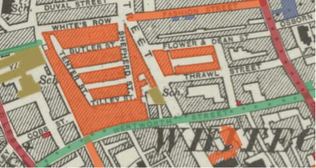
The Memory Map of the Jewish East End Historic Map CC-By-4.0. Reproduced with the permission of the National Library of Scotland
By 1900 the East End was home to over 100,000 Jewish people, most had recently arrived as refugees from Russia and eastern Europe. They settled predominantly in Whitechapel and Spitalfields, the heart of a thriving Jewish quarter, joining an already established community of Jewish migrants from Holland, Germany and other places. By the outbreak of the Second World War, the Jewish population in the area had already started to dwindle. Today very few tangible traces of Jewish East London are left —the kosher shops and restaurants, social and political establishments, synagogues and theatres have nearly all disappeared. The Jewish East End is on the verge of slipping from living memory.
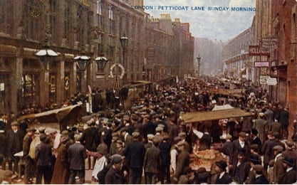
Postcard showing Petticoat Lane market in the early twentieth century
The new website is an interactive ‘Memory Map’ allowing visitors to explore the social and cultural history of the Jewish community in east London. Rachel Lichtenstein’s substantial archive of audio interviews with former and current Jewish residents of East London is brought together with new and archival photographs, material from the Survey of London’s recent work in Whitechapel and other original research, some previously unpublished. Covering more than seventy significant sites, the website aims to become a lasting document of the history and memory traces of the former Jewish East End and to bring the stories, memories, voices and images of this vanishing landscape to new audiences.

Dedicatory plaque on the King Edward VII Memorial Drinking Fountain on Whitechapel Road. Photographed in 2016 by Derek Kendall for the Survey of London

Metal relief sign made for the Jewish Daily Post by Arthur Szyk in 1935 on 88 Whitechapel High Street. Photographed in 2016 by Derek Kendall for the Survey of London
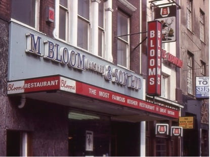
Bloom’s Restaurant, 90 Whitechapel High Street, 1977. Copyright Shloimy Alman
To begin exploring the map, visit https://jewisheastendmemorymap.org/.

A detail from the Memory Map – the Soup Kitchen for the Jewish Poor, 9 Brune Street, Spitalfields
2 Responses to “Memory Map of the Jewish East End”
- 1
-
2
Survey of London wrote on 16 April 2020:

Dear Pat Negal
Thank you for your interest in the Memory Map. Unfortunately it doesn’t stretch quite far enough. I hope you will have found that Beigel Bake near the north end of Brick Lane is included, but there is nothing else up there. The map’s interactive material is necessarily limited to a selection of sites.
kind regards
Peter Guillery
Survey of London

Hello, I have just had a look at the Memory Map. My father was born In Mount Street, a short way north of the Bishopsgate Goods station but the map does not go far enough north. Most of Brick Lane is cut off too. When my grandfather died my grandmother had to move into one room with her four sons at 242 Brick Lane. Should I be able to see these two streets on the map?