X Close

The Survey of London

Home

Recording the history of London's built environment since 1894

Menu

The last jellied eel men in Whitechapel

By the Survey of London, on 12 July 2019

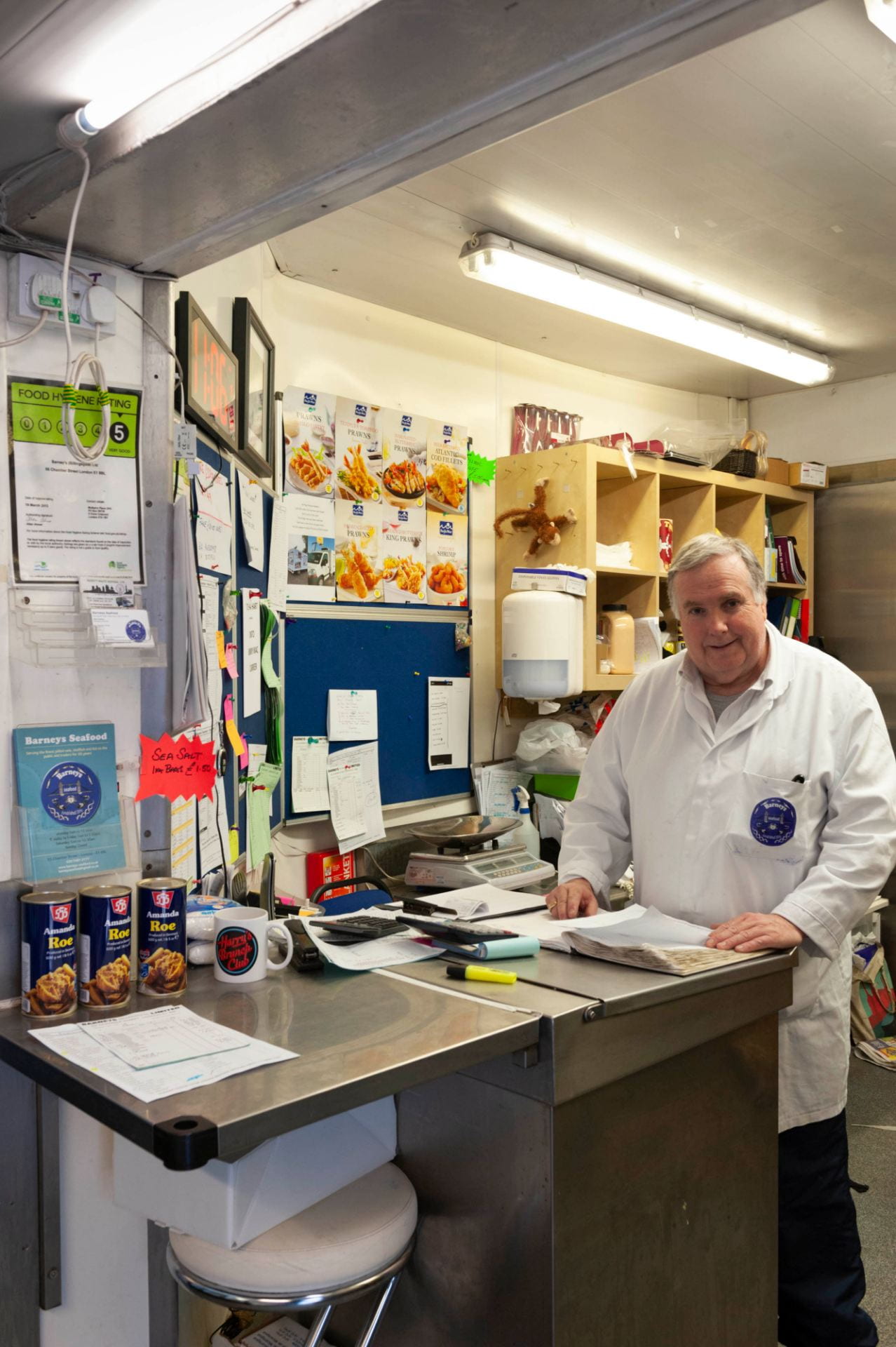
Jellied eels are a delicacy that divides opinion. The cold, viscous texture, and a colour that can only be described as grey, are not immediately suggestive of epicurean treats. But to many East Enders they are the taste of home. This is especially true if they now live a long, long way from Aldgate Pump. Mark Button, managing director of Barneys Seafood, the last jellied eel company in Whitechapel, knows this only too well. ‘We send them all over the country… We post them up to Scotland and Wales, a lot to the South coast, the Kent coast is still a very good area for jellied eels and even down to Devon and Cornwall.’ But sadly, though Mark plans to carry on jellying eels, from the end of September it won’t be in Whitechapel. Gentrification has caught up with the railway arches in Chamber Steet, in the south-west corner of Whitechapel, a stone’s throw from the Tower of London, that have housed Barneys for more than fifty years.

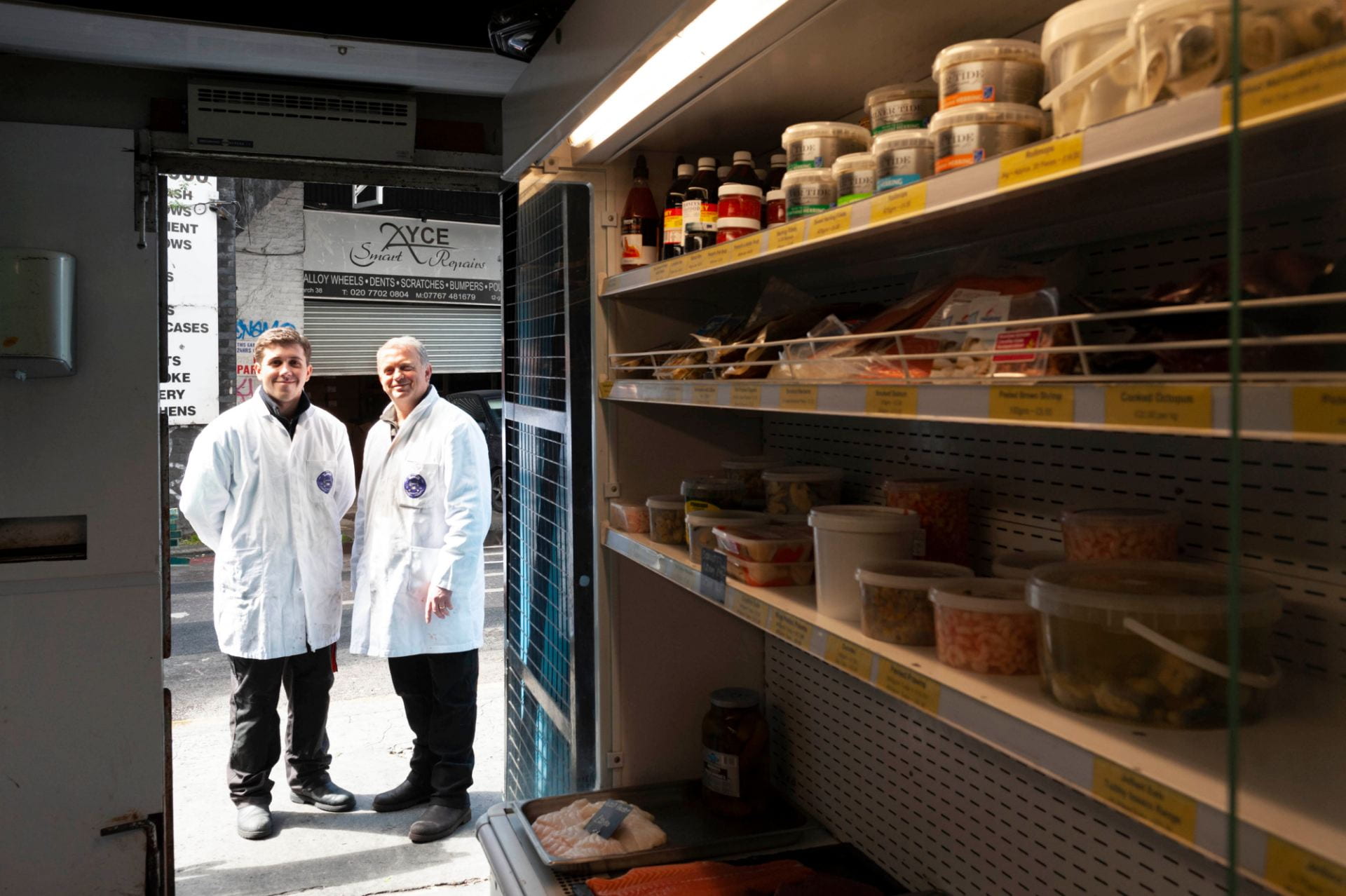
Mark Button, right, Managing Director of Barneys Seafood, outside the shop door at 55 Chamber Street, with his son Harry. Photographed in 2019 by Derek Kendall for the Survey of London.

Jellied eels are a cheap, traditional London dish going back to the eighteenth century. Eels were formerly plentiful in the Thames downriver towards the estuary, and the method of preparation served both to cook the eels and to preserve them. Though nowadays you are more likely to find them on a day out to the seaside at Southend or the south coast, both areas that buy Mark’s eels in large quantities, up until the 1970s jellied eels were readily available on market stalls and in pie and mash shops throughout east and south London. Only a few of these vendors now remain.

The most famous of jellied eel stalls in Whitechapel was Tubby Isaacs at Aldgate, at the south end of Petticoat Lane market. The original Tubby Isaac was Isaac Brenner, who opened his stall in Whitechapel in 1919, but emigrated to the United States in 1940.[1] Tubby Isaac’s or Isaacs, as the stall came generally to be known, was taken over by Soloman Gritzman – with Brenner’s departure Gritzman ‘became’ Tubby Isaacs.[2]

Solly Gritzman had a brother, Barney, who was in the same line of work and it is from Barney Gritzman that Barneys Seafood is descended. But, as with many East End stories, this was no tale of brotherly love. ‘There was a feud between the two brothers’, says Mark. ‘They had stalls opposite each other but they didn’t speak… they’d even spit at each other.’ This went on for more than twenty years.

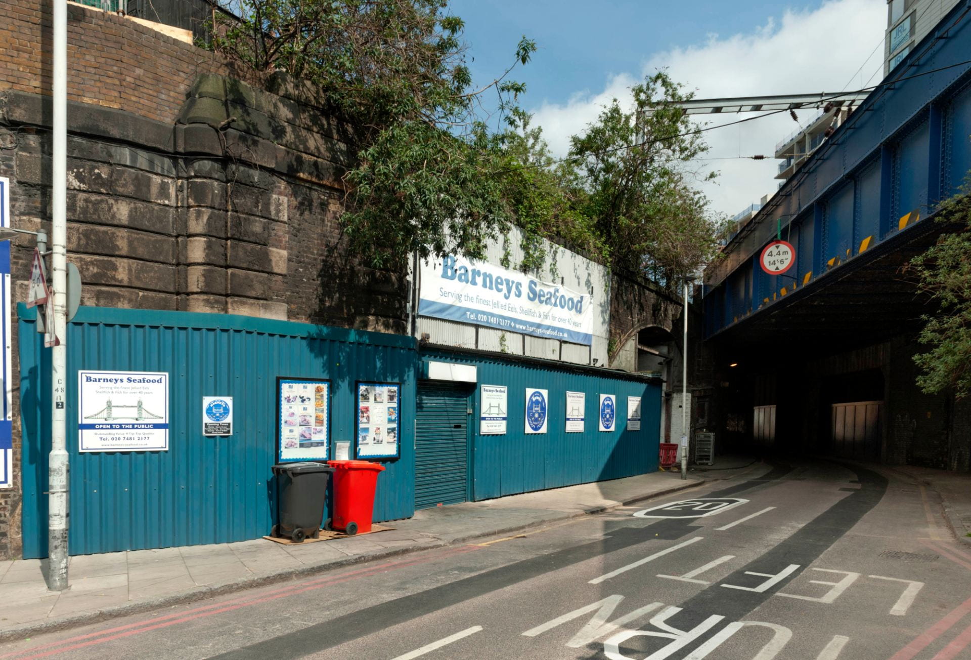
Barneys Seafood, tucked under in railway arched a stone’s throw from Tower Bridge. Photographed in 2019 by Derek Kendall for the Survey of London.

Barney Gritzman had taken over the railway arches in Chamber Street as a lockup for the stall at Aldgate. At that time they really were railway arches, sitting under the junction of two different railways – the surviving line which had begun as the London and Blackwall, one of London’s earliest railways, leading to Fenchurch Street station, and the London and North Western Railway branch leading up to the Haydon Square goods depot, between Mansell Street and the Minories. That branch line closed in the late 1960s, when Barney’s shop and factory became a railway arch without a railway. This was the point at which Mark Button’s father, Eddie, took over from Barney Gritzman.

‘My Dad was one of fourteen children of a builder but decided he didn’t want to do that so he started to look around for other work. He started in a pie and mash shop, handling eels. He worked for Cooke’s pie shop in Stratford, and he then got a job at the old Billingsgate Market in Lower Thames Street working with eels, being a blocksman with fish, where they would prep fish for West End restaurants, and finally he bought Barney’s seafood stall at Aldgate in 1969.’

It was in the Chamber Street arches that Eddie Button developed the eel preparation and wholesaling business. The Gritzman brothers’ feud carried on even after Eddie Button took over Barneys, though, when, as Mark relates, Solly ‘Tubby Isaacs’ Gritzman ‘decided he didn’t want to do his own jellied eels any more and asked my father to do his eels as well, with the understanding that no one could know it was the same supplier supplying both Tubby Isaacs and Barneys’.

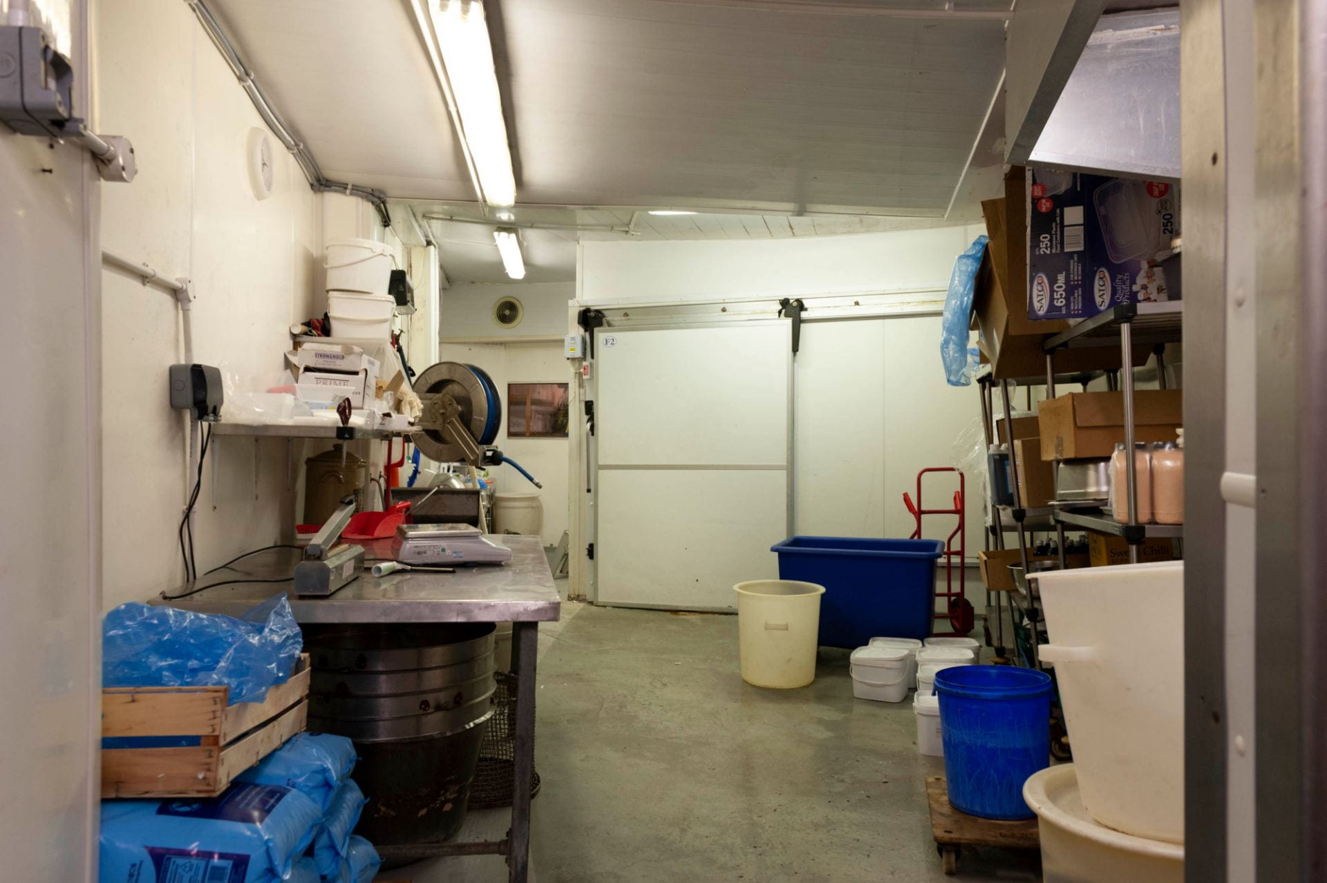
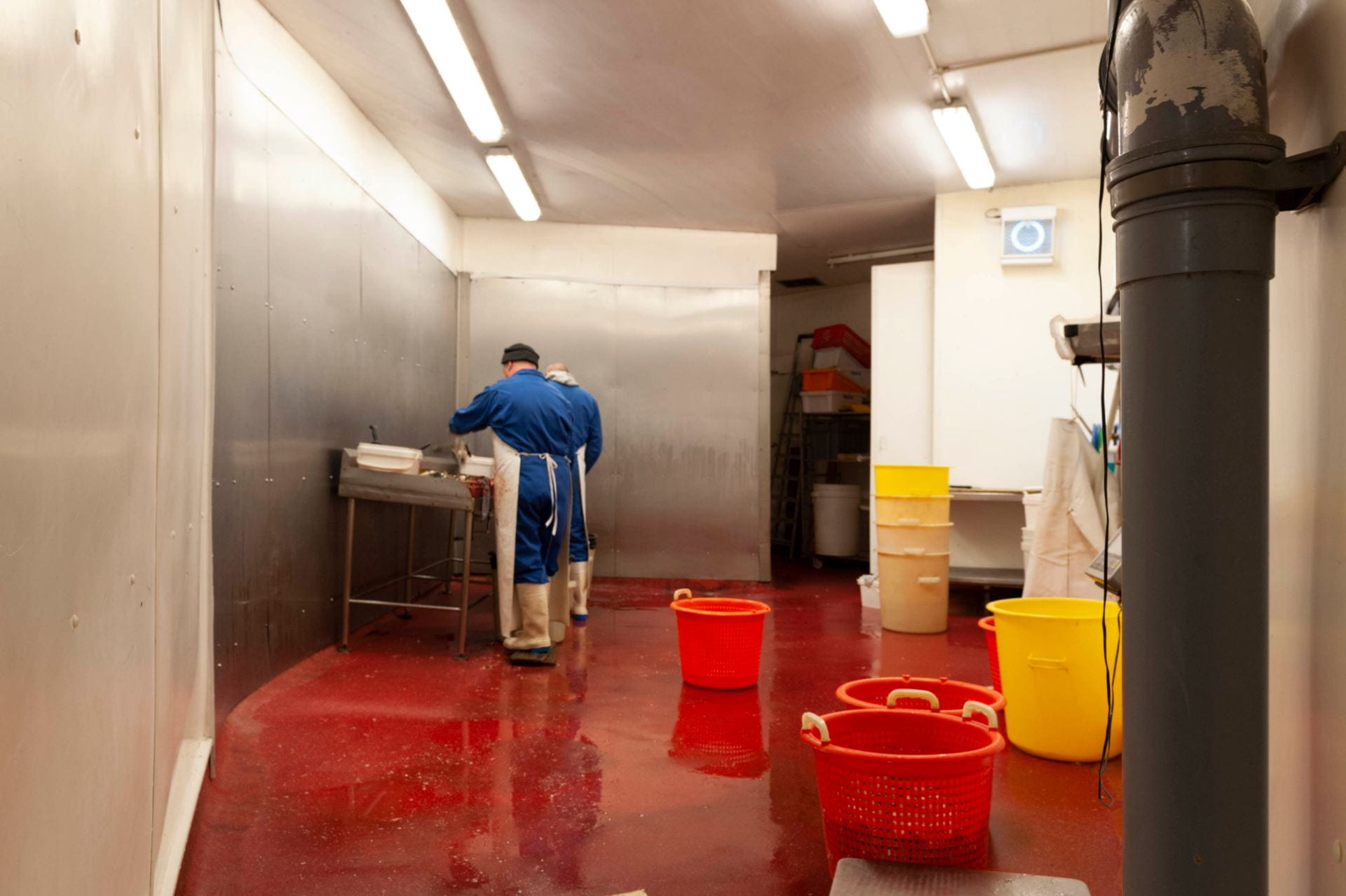
The cleaning room, at Barneys Seafood, 55 Chamber Street, the first stop fot the shipments of eels. Photographed in 2019 by Derek Kendall for the Survey of London.

Mark joined the firm in 1983, when he was 18, and despite the enormous demographic and culinary changes in East London in the past thirty-five years, has sustained and developed the business. ‘When I first came here we did ninety per cent jellied eels and ten per cent other shellfish … now we possibly do forty per cent jellied eels and sixty per cent other shellfish, but that forty per cent is still a large percentage of the eels industry for the south of England.’

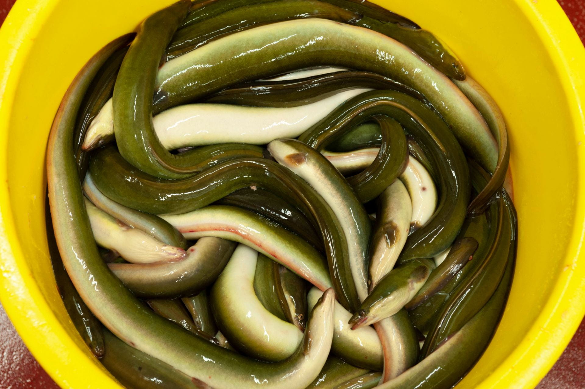
A bucket of cleaned eels awaiting preparation. Photographed in 2019 by Derek Kendall for the Survey of London.

The processes that go on in the arches have not changed much over time. In the summer months shipments of wild eels are flown in overnight from Lough Neagh in Northern Ireland, arriving fresh for processing at Chamber Street in the early hours of the morning. In the winter the eels come in container lorries, once a week or once a fortnight, from eel farms in the Netherlands.

The eel preparation room at Barneys Seafood, 55 Chamber Street. Photographed in 2019 by Derek Kendall for the Survey of London.

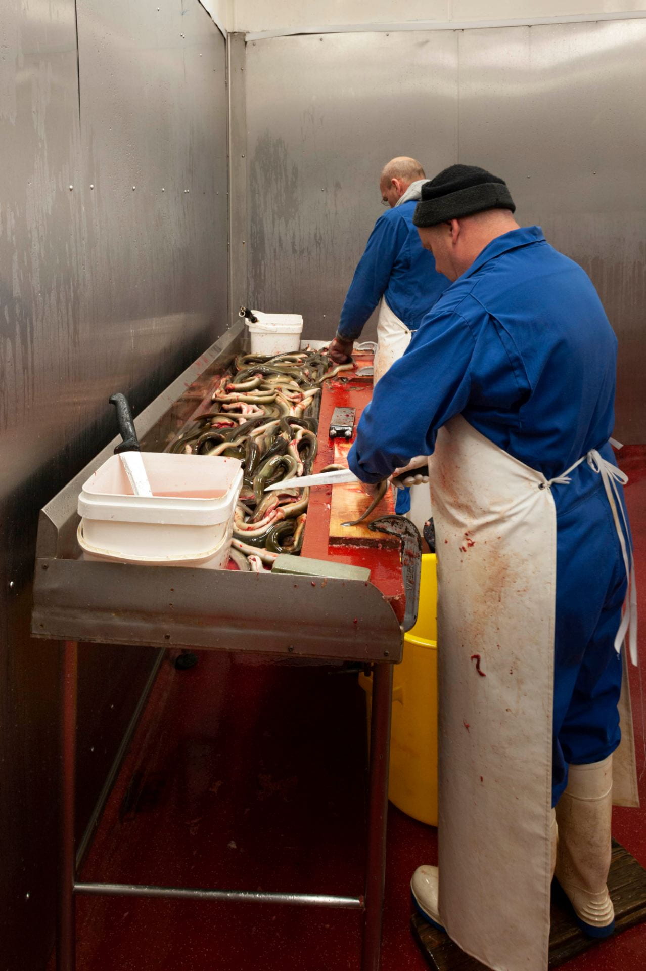
Ginger and Simon gutting and cutting eels in the preparation room at Barneys. Photographed in 2019 by Derek Kendall for the Survey of London.

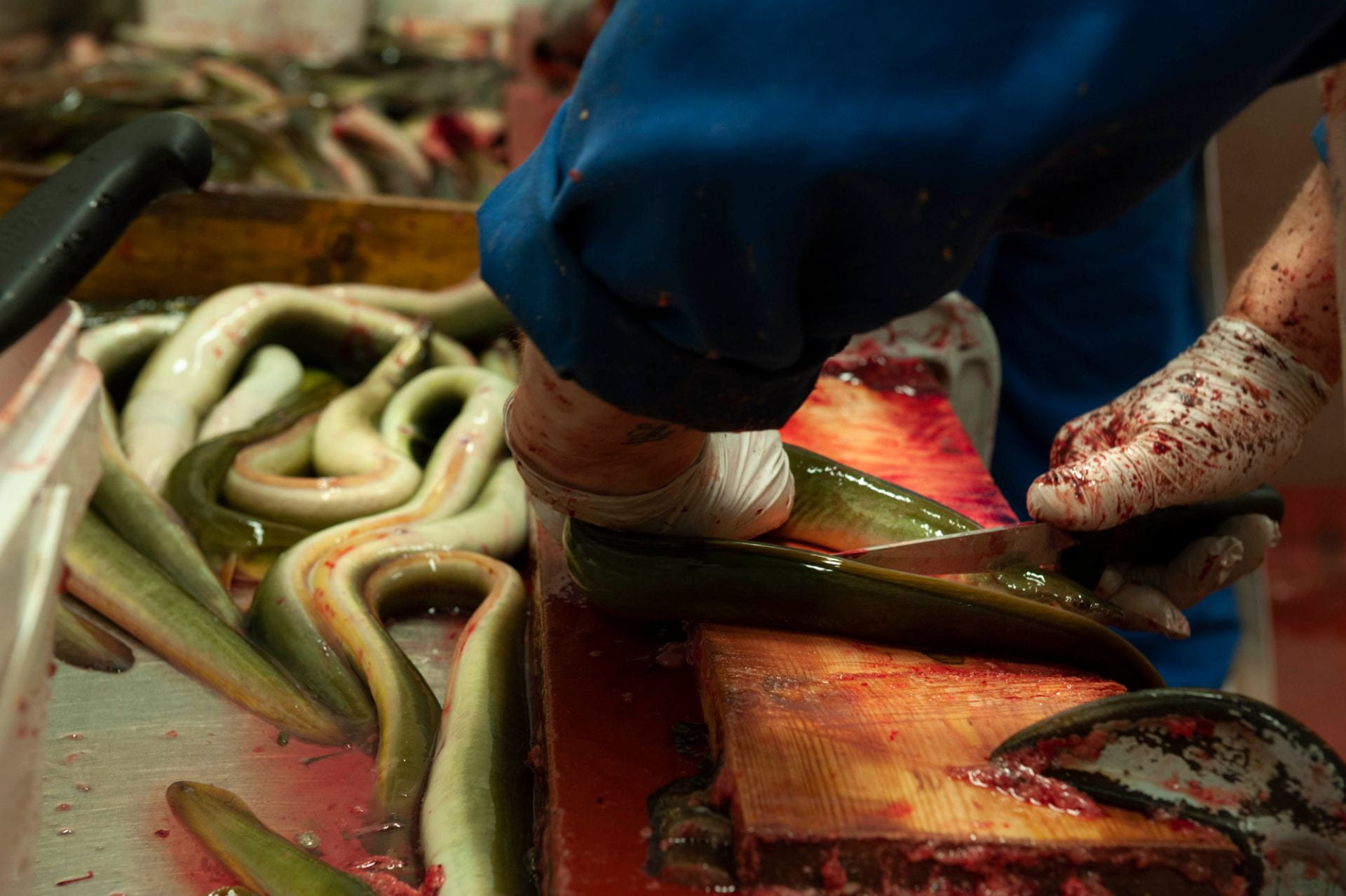
Ginger guts the eels before they are chopped into bite-size pieces prior to boiling. Photographed in 2019 by Derek Kendall for the Survey of London.

‘The eels are then cleaned and gutted, as one process, then they’re cut in to mouth-size pieces, then it’s all washed and then the raw material is cooked in boiling water.’

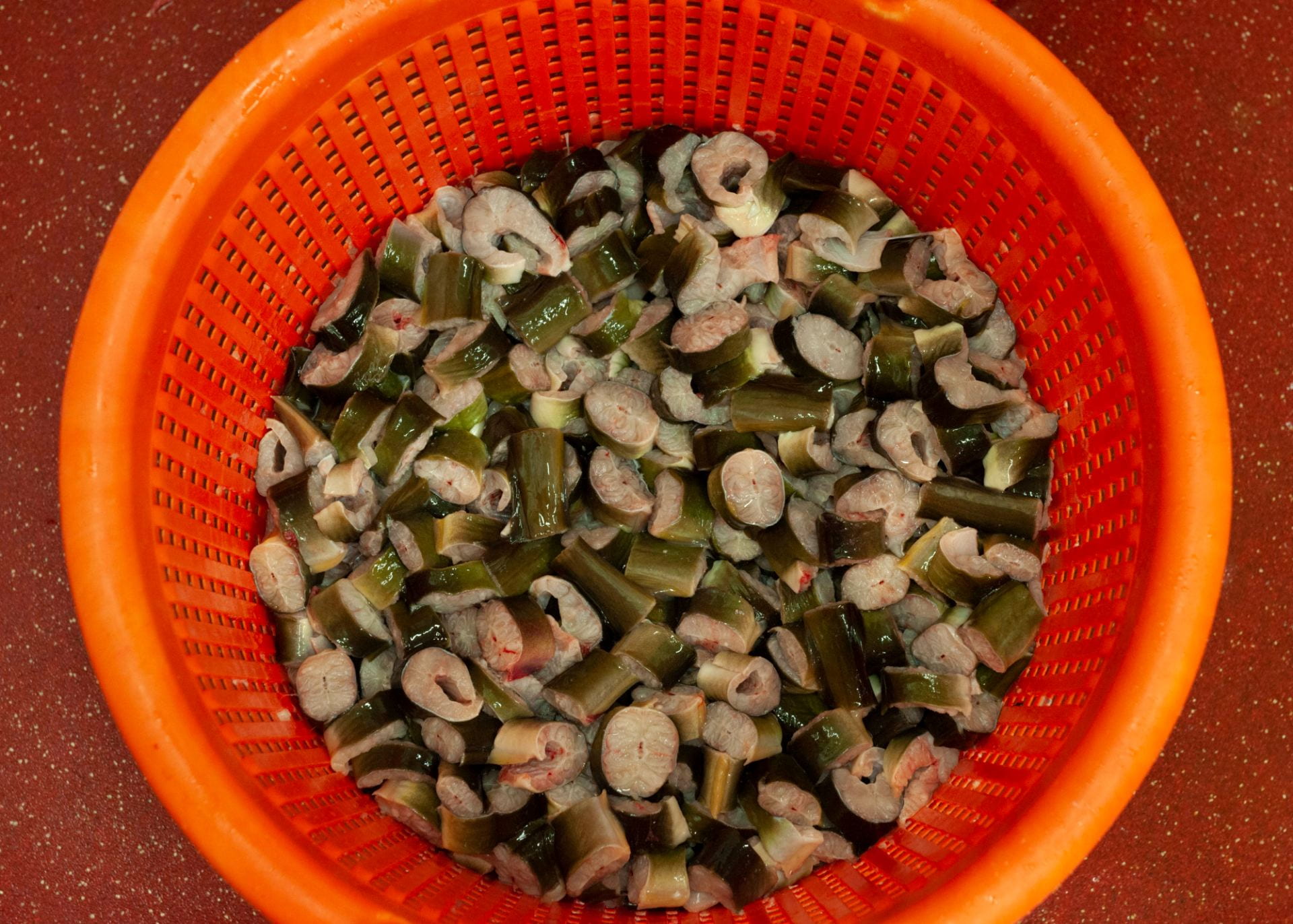
Eels chopped into pieces at Barneys Seafood before they go to the boiling room. Photographed in 2019 by Derek Kendall for the Survey of London.

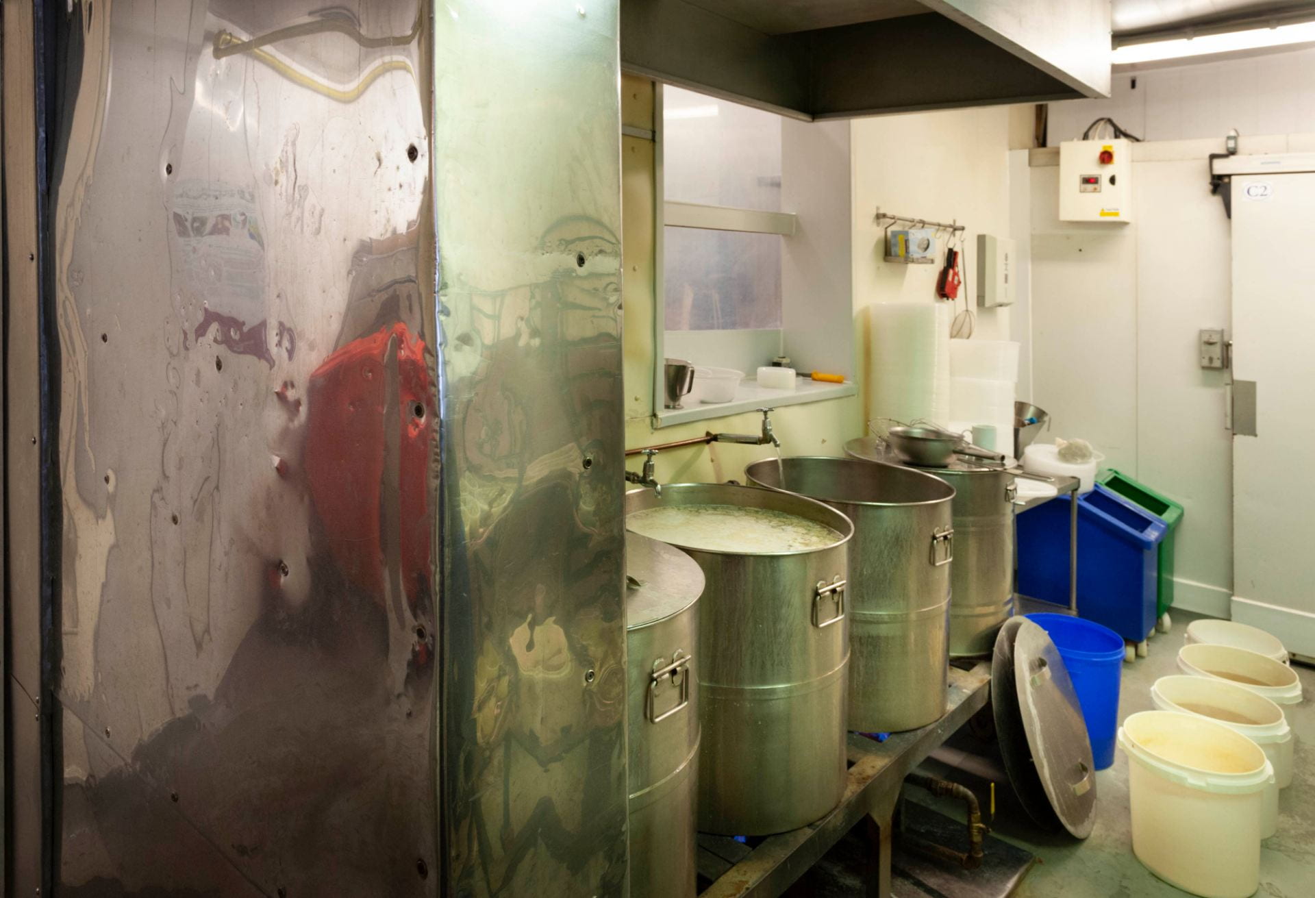
Vats of boiling water, salt, gelatine, parsley and a blend of spices await the chopped eels in the boiling room at 55 Chamber Street. Photographed in 2019 by Derek Kendall for the Survey of London.

‘We add some salt and some spices just to take off any earthiness the wild eels might have, and because of the volumes we’re cooking we have to use a gelatine-based product to set the eels in. It’s a boiling liquid that then gets put in to a fridge overnight and the following day they are set as jellied eels.’

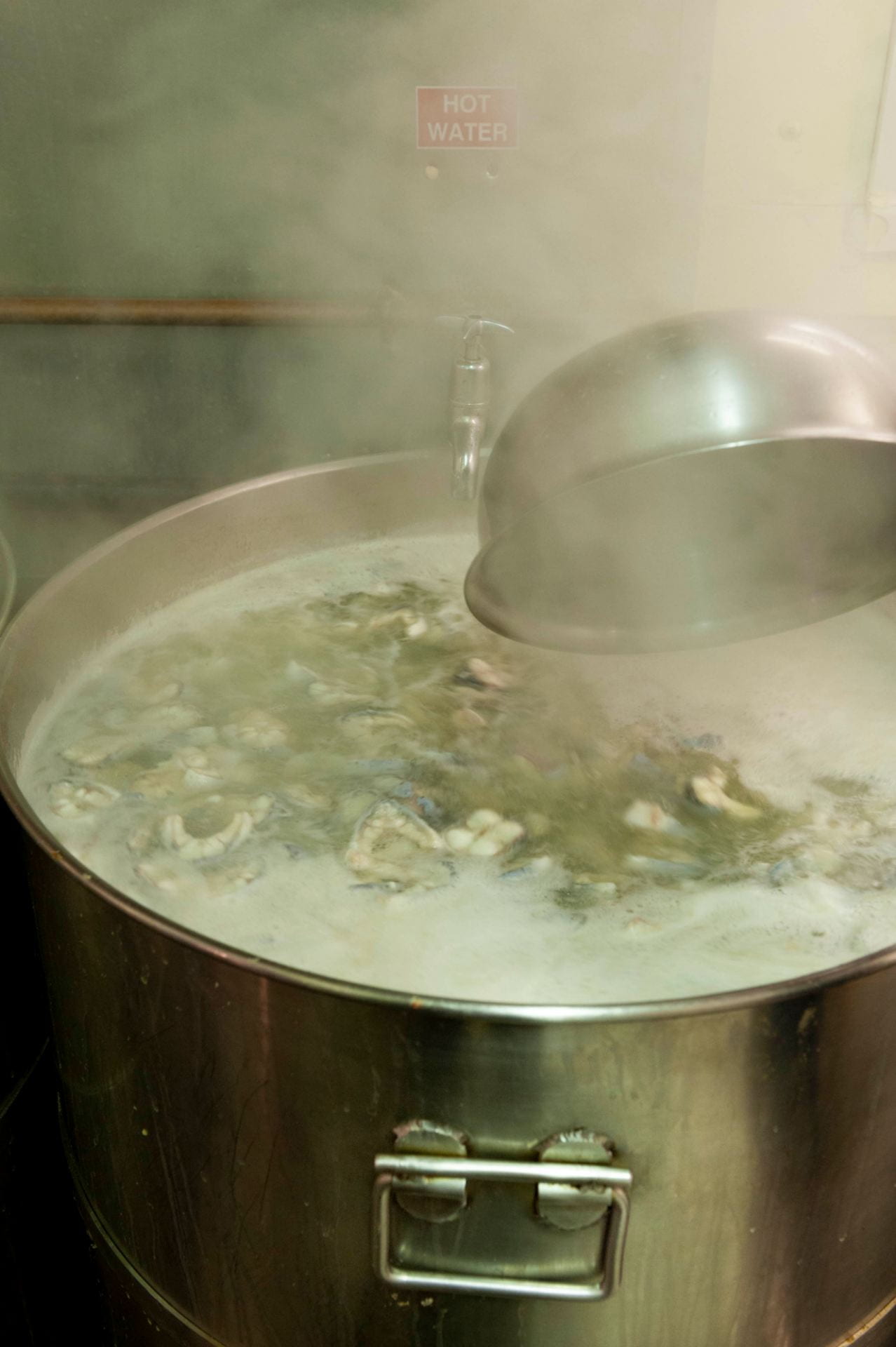
Chopped eels bubbling away in steel vats in the eel-boiling room at Barneys Seafood. Photographed in 2019 by Derek Kendall for the Survey of London.

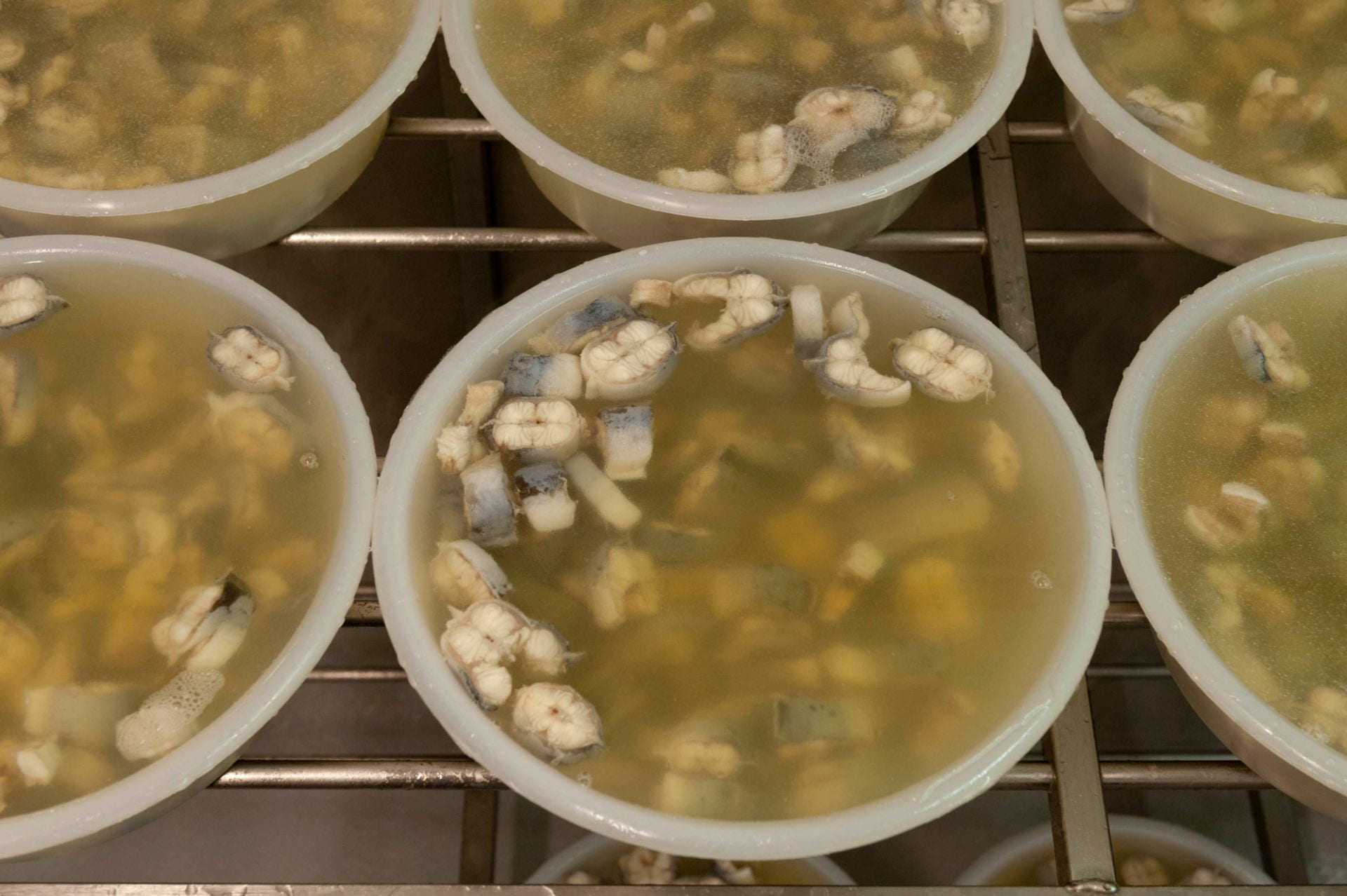
Portioned jellied eels and liquor. Photographed in 2019 by Derek Kendall for the Survey of London.

The stall at Aldgate closed about six years ago. ‘With the red routes, no parking, double yellow lines, no taxi drivers allowed to stop, changing it all back to a two-way system from one way, the Congestion Charge, all these things put people off coming in to certain areas so it slowly killed the trade.’ But as one door closed another opened – literally. ‘When I first came here, we’d walk in in the morning and we used to close the door behind us, because there was so much work going on in the factory, my father didn’t encourage anyone off the street to come in. We were so busy no one had time to go and serve anybody. It’s only possibly been in the last ten or twelve years, since my father hasn’t been around, that we’re not doing as much work. So you open the doors, you put some freezer display cabinets in, people can come in and see what you do.’

‘We open the doors about 4.30 am and we’re here most days till about 1.30 in the afternoon. We’ve had to develop with the times … it’s about thirty per cent of the business I think now, people that walk in off the street. We supply cool bags and we’ve got a good little following, whether it’s people visiting for the day, students staying here, people sailing their boats into St Katharine’s Dock … we get everyone coming here. And you don’t know who they are till you start talking and … you know they’ve been sailing for six months and they come back here every year or so, and they come and find us again. And it’s retired people from America, all walks of life, you know, whether they’re scraping together a few pennies to buy something or they’re multimillionaires who just love a bit of jellied eels and seafood.’

Charles ‘Frank’ Mathews at the shop counter. Photographed in 2019 by Derek Kendall for the Survey of London.

The changing demography of the area around Chamber Street has been a boon to Barneys. ‘This was already a busy area, most of the time, but at weekends we’ve got more Europeans moving in, Leman Street has got a lot of Chinese and Asian students coming in from the Far East. It creates a different dynamic in the area, there’s the bars and restaurants, there are City people during the week and a lot of students at weekends, but they also like fresh fish and live produce, so we’ve got busier in our local trade over the last two to three years.’

There is a slightly bitter irony to this, of course. Last year Mark had a bit of a shock. ‘We got a letter from Network Rail, our landlord, saying the site had been sold. After fifty years of paying our rent on time, every time …’ In January 2019 the new owners, the developers Marldon, told Mark that Barneys would have to leave at the end of September. Mark is philosophical: ‘Well, they are developers. I think they’ve got an apart-hotel planned for the site.’

‘We’re looking at a few options at the moment.’ They may move in to Billingsgate Market, but that may itself soon be on the move for the same reason as Barneys. ‘In 1982 the fish market moved from Lower Thames Street to Canary Wharf which was the great move at the time, with readymade car parks and readymade cold stores, and it was hi-tech at the time. It’s not hi-tech today and the land values of Canary Wharf have outstripped the usage of a fish market which only trades from 3am until 9am.’ The market owner, the Corporation of London, has been contemplating moving all the old produce markets – the fruit and veg at Leyton, fish at Canary Wharf and, oldest of all, meat at Smithfield to a single site at Barking. ‘With the prospect of moving to Barking, with the new market, we’ll see what that brings with a multicultural type of market. There’s still a call for traditional shellfish. The jellied eel side of the business is declining but with trends changing and different types of people moving in to the area, people are willing to try these things again.’

So he is not downhearted. ‘You know, I could have panicked, shut up the shop and said “That’s it, had enough, going to do something else.” But because I came here at the age of 18 and apart from the 3am alarm going off most mornings …  I’m fortunate my son’s now in the business, he’s 21, he wants to carry on doing it, he enjoys it, in some sad way as we all do. Once it’s in the blood I think it’s always there.’

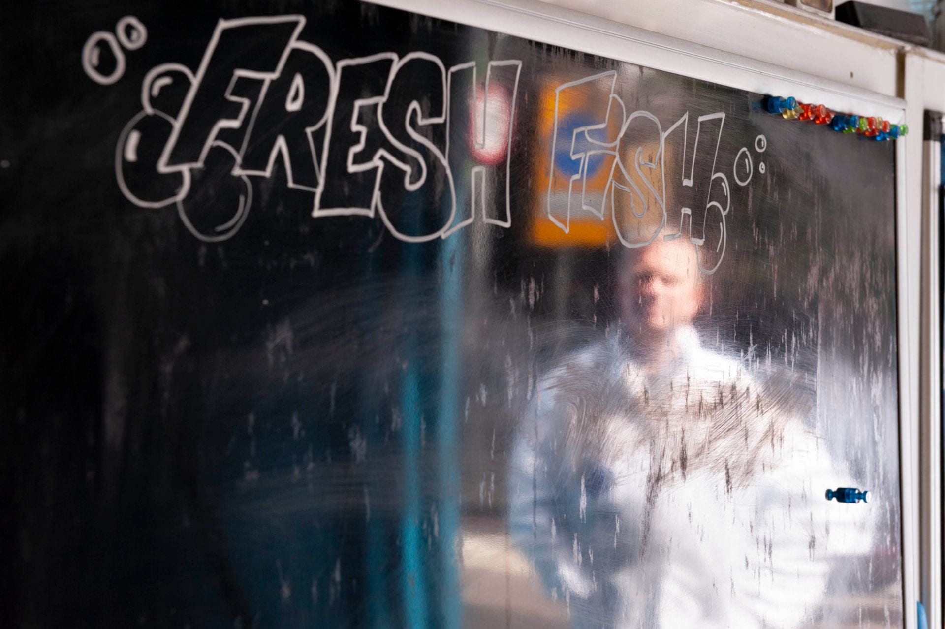
Mark Button reflected in the frontage of Barneys Seafood, 55 Chamber Street. Photographed in 2019 by Derek Kendall for the Survey of London.

Mark Button was talking to Aileen Reid from the Survey of London at 55 Chamber Street on 26 June 2019.

Barneys Seafood will be at 55 Chamber Street, London E1 8BL till the end of September 2019: https://www.barneys-seafood.co.uk/

Solly Gritzman can be seen at his Tubby Isaacs stall, talking about Petticoat Lane market, in a BBC documentary from 1968, about four minutes in on the timer: https://www.bbc.co.uk/iplayer/episode/p00t3mkz/one-pair-of-eyes-georgia-brown-who-are-the-cockneys-now

References 

[1] Ancestry.co.uk: Daily Mail, 2 Sept 1926, p. 3

[2] The People, 17 March 1974, p. 2

Wombat’s City Hostel, formerly the Sailors’ Home

By the Survey of London, on 19 April 2019

This hostel on Dock Street sustains an institutional use that has its origins in the 1830s when the establishment opened as the Sailors’ Home, a reflection of the dependence of the southern parts of Whitechapel on maritime life. It is a large complex that extends back to Ensign Street (formerly Well Street), its original front.

Wombat’s City Hostel, 7 Dock Street, London E1. View from the west in 2017. Photograph by Derek Kendall for the Survey of London

The Sailors’ Home, also known at first as the Brunswick Maritime Establishment, was built in 1830–5 with Philip Hardwick as its architect. Enlarged to Dock Street in 1863–5, substantially altered in 1911–12, rebuilt on the Dock Street side in 1954­­–7, adapted to be a hostel for the homeless in 1976–8, and again converted to be a youth hostel in 2012–14, this has been, mutatis mutandis, a major local presence for nearly two centuries, all the while used as a hostel. As the first purpose-built short-stay hostel for sailors anywhere, it represented in its original form the invention of a building type, the Royal Hospital for Seamen in Greenwich notwithstanding. It was to have seminal influence on the development of lodging-house architecture.

The Ensign Street elevation and former front of the Sailor’s Home in 2015

The story starts with a catastrophe, the collapse of the Royal Brunswick Theatre just days after its opening in February 1828. Thirteen people died and Hardwick, the architect at the neighbouring and then building St Katharine’s Docks, was the first on the scene of the disaster to take responsibility for the rescue operation. Of the theatre, all that survives is on the Ensign Street pavement, a row of (listed) cast-iron bollards with crowned ‘RBT’ monograms.

The Royal Brunswick Theatre bollards of 1828 on Ensign Street, photographed by Derek Kendall for the Survey of London in 2017

The prevalence of sailors in east London’s riverside districts was not new at the beginning of the nineteenth century, but populations did increase and living conditions declined. The end of the Napoleonic Wars in 1815 left an estimated 100,000 seamen redundant from the Royal Navy. The Rev. George Charles ‘Boatswain’ Smith (1782–1863) came to the fore in addressing the lot of these sailors through evangelism. A seafarer himself in his teens who had served with distinction under Nelson in the battle of Copenhagen, Smith had become a Baptist missionary. He established a floating sanctuary on a remodelled sloop and took the former Danish Church in Wellclose Square for use as a Mariners’ Church. A witness to extreme poverty and deprivation, he was instrumental in the taking of a warehouse in Dock Street to establish an asylum for destitute sailors that opened in January 1828. Smith was also a pioneering advocate of temperance.

Paid upon coming ashore, sailors, both naval and mercantile, were prey to exploitation and theft by boarding-house and brothel keepers and others, a practice known as ‘crimping’ that was widespread and generally tolerated. Smith was determined to force reforms and had tried to introduce a system of approved boarding houses as used in other ports. In his eyes the Royal Brunswick Theatre and its predecessor, the East London Theatre, had been a haven for crimping. The collapse presented an opportunity. In September 1828 Smith convened a meeting on the site with a view to raising there ‘a General Receiving and Shipping Depot for Mariners’.[1] This was to be a religious mission, aiming at moral reform through reducing the influence of prostitution and drink. As such it was a late example of the Georgian impulse to improvement and control through institutional architecture. Alongside Smith were Captains Robert and George Cornish Gambier, RN, brothers, and nephews of Admiral James Gambier, himself an evangelical, and Capt. Robert James Elliot, RN, who was also a topographical artist. Appeals were launched in early 1829, aiming to unite ‘the Regularities of social Order with the moral Decencies of Life, the Principles of Christian Loyalty, and the Duties of Religion.’[2]

Within the year eminent naval and other figures had been recruited to promote fund-raising (first trustees included William Wilberforce) and the freehold of the site was obtained. But Smith, an uncompromising and combative character, fell out with George Gambier, the Treasurer, over the latter’s unworldly sympathies for Henry Irving’s radical Nonconformity that had led him to leave fund-raising to faith. Smith stepped down as Secretary and set up a rival Sailors’ Rest project leading other Dissenters to withdraw support for the Home. Elliot took charge as the Home’s Secretary and steered the project into Anglican safety. Hardwick was engaged and on 10 June 1830 Elliot laid a foundation stone. Hardwick conceived the project in stages, to be built gradually as funds became available, ultimately to provide space for 500 men, each with their own cabin or sleeping place. Progress was slow and the Home did not open until 1 May 1835, with accommodation for 100 men on its lower levels. The first sailors admitted were the crew of an American ship in St Katharine’s Docks. A peaceful atmosphere introduced by the ‘sobriety and steadiness’ of these ‘temperance men’ was broken a few days later by the arrival of English sailors, coming from India and bringing ‘intoxication, swaggering and noise’.[3]

The Sailors’ Home of 1830–5, Philip Hardwick, architect, from the British Workman, 1857 (courtesy of Tower Hamlets Local History Library and Archives)

The Sailors’ Home’s façade echoed that of the theatre in its bay rhythm and the ground-floor channelled rustication. It may even be that the lower-storey wall was not wholly rebuilt. Hardwick connected the outer bays with a portico of large cast-iron Doric columns similar to those he had placed at St Katharine’s Docks. These columns were removed in 1952. The central part of the basement was a vaulted store that survives as a bar. The main central space at ground-floor level was a waiting hall open to all seamen. It had a York stone-flagged floor with a grid of nine tall cast-iron columns. The floor and columns are both still partly extant, but concealed. This hall was also used for assemblies and worship, and had small box offices for payment and registration, where the men’s ‘characters’ were recorded. Flanking dormitories named ‘Bombay’ and ‘Calcutta’ had two tiers of cabins, probably drawing on the precedent of Greenwich Hospital’s accommodation for naval pensioners. On the originally comparably tall first floor a central dining and reading hall had a similar array of columns and was flanked by two more double-tiered dormitories (‘Canton’ and ‘Madras’). Upper floors were initially used for a school, lecture room and museum of ship models and curiosities. As inmate numbers grew in the 1840s the outer upper-storey rooms were gradually fitted up as further dormitories, and a single bath was introduced.

Basement vaults in the building of the 1830s, converted to use as a bar. Photographed in 2019 by Derek Kendall for the Survey of London

Henry Mayhew, in a full description that was not uncritical of the Home’s management, noted in 1850 that seamen addressed the institution’s officers as friends not as superiors, and recorded a testimony from one among them that ‘the steadiest-going seamen will always speak well of the Sailors’ Home’.[4] Henry Roberts, closely familiar with the Home having acted as its architect in the 1840s when he was also the first architect of the pioneering Society for Improving the Condition of the Labouring Classes and responsible for model lodging houses, later acknowledged that the Sailors’ Home ‘must in some respects be considered the prototype of the improved lodging-houses.’[5] Annual numbers of boarders rose from 528 in the first year to 3,833 in 1842 and 8,617 in 1861. Most of the sailors were of British or North American origin, but not all. By 1862 there had been 544 boarders from Africa.

Land behind the Home had been leased in 1842 with a view to possible extension, and was used in the meantime as a skittle ground. Dock Street was widened in 1845–6 and parts of the new frontage were acquired between 1854 and 1862 when Edward Ledger Bracebridge, a Poplar-based architect, designed a new block facing Dock Street. Lord Viscount Palmerston laid the foundation stone on 4 August 1863 and the Prince of Wales opened the building on 22 May 1865. A commemorative stone plaque bearing that information is still to be found facing the hostel’s internal courtyard where it was moved, recut, in 1956.

View down Dock Street showing the Sailors’ Home extension of 1863–5, with St Paul Dock Street beyond

The outwardly Gothic and polychrome Dock Street building’s basement housed a navigation school, a recreation room and two baths. The ground floor had offices to the front, including a seamen’s savings’ bank, with waiting halls to the rear, the first floor a boardroom and officers’ mess room to the north, and a library and recreation hall to the south. The two upper storeys were laid out as a single room, the Admiral Sir Henry Hope Dormitory. This extraordinary space comprised four galleried tiers of sleeping berths or cabins (108 in all) to east and west of an atrium open to the roof with south-end staircases (see images in Historic England Archives). The gain in accommodation was 160 berths for an overall capacity of 502.

In 1874–5 a single-storey skittle alley to the rear was reconstructed, extended to the south and raised to be a three-storey and basement range to provide an additional dormitory for ships’ mates and a clothing store, sales of clothing from the Home having been introduced in 1868. John Hudson and John Jacobs, both of Leman Street, were architect and builder respectively. A drinking fountain near the northwest corner of what was the main waiting hall is surmounted by an inscribed plaque recording a benefaction of 1873 from William McNeil, a formerly resident seaman.

Drinking fountain and plaque on what was an internal wall of the waiting hall, photographed by Derek Kendall in 2019 for the Survey of London

By this time there were many other hostels for sailors, but the Sailors’ Home was the parent exemplar. Outside, crimping was still prevalent, and the Home was drawing more than 10,000 boarders annually. Ale was served, but there was no bar. It remained a Christian foundation, but not zealously so, aiming to ‘encourage habits of decorum, economy, and self-cultivation, and to contribute in educating [seamen] as missionaries of Commerce to the ends of the earth’.[6] Between 1879 and 1884 Joseph Conrad (Jozef Korzeniowski) stayed several times at the Home and studied in its navigation school. Conrad called the Home a ‘friendly place’, ‘quietly unobtrusively, with a regard for the independence of the men who sought its shelter ashore, and with no ulterior aims behind that effective friendliness.’[7]

Internal courtyard from the north, showing the 1870s range to the left, a surviving section of the 1860s building straight ahead and the back of the 1950s building to the right. Photographed in 2019 by Derek Kendall for the Survey of London.

In 1893–4 the original building’s south range and a stable yard beyond were replaced by a Mercantile Marine Office, which building survives on Ensign Street. That sacrifice reduced the Home’s capacity to 300, a limit that had further to be reduced to 200 following a threat of closure in 1910 when the LCC stipulated improvements to the original dormitories, in particular for the provision of light. Murray, Delves & Murray, architects, oversaw works carried out in 1911–12 that involved the insertion of an additional floor in the Ensign Street block. Internal reconstruction formed a light-well above the ground-floor waiting hall, with structural steel carried down to the basement. Bars and a first-floor chapel were introduced and a house was demolished to permit the formation of windows in the Home’s north flank wall, which was faced with channelled rusticated render. Following this reconfiguration the establishment rebranded itself, incorporating as the Sailors’ Home and Red Ensign Club in 1912. Despite the reduced berths, the numbers of boarders continued to average more than 10,000 a year. By 1919 the Home had admitted a total of 639,005 sailors, 336,088 of them English, 51,388 from Sweden, Norway and Denmark, 18,500 from Germany, 11,376 from Russia, 2,483 from the ‘Cape and Mauritius’, 1,154 from West Africa, 7,958 from the West Indies, 2,523 from the East Indies, 1,914 from South America, and 1,387 from China and Japan. After this, the origins of the sailors were no longer recorded in annual reports.

More than 20,000 were boarded in 1933, usage that was sustained after the war when the merchant navy reserve pool was introduced, bringing seamen greater security of employment. Additional accommodation being needed, the Home’s architect, Colin H. Murray of Murray, Delves, Murray & Atkins, advised a comprehensive approach in 1937 and was asked to prepare plans for complete rebuilding. War meant postponement, but Murray did advance a scheme for rebuilding the Dock Street building in 1942.

By 1945 Murray was working with Brian O’Rorke on a more ambitious phased project for the replacement of the whole complex (now simply called the Red Ensign Club). This envisaged three slab blocks laid out on an offset H plan to make best use of the two street frontages, rising at the centre to twelve storeys for a total 307 bedrooms (no longer called cabins) above lower-level common spaces. LCC approval was secured, but in the post-war years building licences were not forthcoming. O’Rorke (1901–74), New Zealand born, had come to notice in placing joint third in the competition to design the RIBA’s headquarters and gone on to build a reputation for designing passenger-ship interiors. In 1946 he succeeded Edwin Lutyens as architect for the National Theatre, for which his designs remained unbuilt. He took over as architect for the new Club, leaving Murray, Delves, Murray & Atkins in charge of maintaining the existing buildings.

Costs kept rising with inflation and a diminishing number of boarders gave rise to concern in 1949 that expansion was no longer warranted. O’Rorke scaled down the plans by two storeys, and a licence for the first phase was granted in 1950. A new problem arose when the Merchant Navy Welfare Board was unable after all to contribute funds. With a shortfall of £35,000 of an estimated £275,000, and costs still rising, in 1951 O’Rorke suggested rebuilding the Dock Street range with the taller central block to its rear for £160,000 to prevent further delay. This was agreed and Charles Price Ltd was given the contract for the new building for £179,488 in March 1952. First Hardwick’s Ensign Street block was re-modernised, to plans by Murray with R. Mansell as contractor. A staircase was inserted in the northeast corner of the ground-floor lounge, which was otherwise laid out with a billiard table and a ‘television set’. The Dock Street rebuilding ensued from 1954 and was completed in 1957 for a final cost of £218,400. Even so, the central block had also had to be abandoned, the new capacity was just 240 and there was a deficit of £63,000.

O’Rorke’s building has six storeys and a setback attic, a steel frame and reinforced-concrete floors, metal windows and copper roof covering. Above curtain-wall glazing for the façade of the two lower storeys that housed communal spaces, it is brown-brick clad, flat-faced Modernism that is herbivorous yet stark. A lighter touch was introduced in the intertwined rope-pattern ironwork of the first-floor balconettes. A lift motor-room tower rising above the southeast staircase was a remnant of the centre-block plan. There had been disagreements as to the relative size of cabins (still, after all, so-called) for seamen and officers. The hierarchical view prevailed and it was 1966 before washbasins were installed in each room.

Following the closure of the London and St Katharine’s Docks in 1968–9 and continuing financial difficulties, the Red Ensign Club closed at the end of 1974. Hostel use was quickly re-established, the buildings being converted in 1976–8 for the Look Ahead Housing Association Ltd (Beacon Hostels) to adapt the complex for single homeless men. Christopher Beaver Associates were architects for the conversion. Capacity at what came to be called the Aldgate Hostel (sometimes Beacon House) shrank from 180 to 150 beds. Many of those housed were construction workers and there was also use as a halfway house for men released from prison. By 2012 Look Ahead had closed this and all its other large ‘industrial-era’ hostels.

Wombat’s City Hostel’s entrance foyer from the south in 2019. Photograph by Derek Kendall for the Survey of London

Another conversion was carried out in 2012–14, the property having been acquired by Michael Sherley-Dale, whose residential property company, JMS Estates (IOM) Ltd, leased the premises to Wombat’s Hostels. This firm, founded by Marcus Praschinger and Sascha Dimitriewicz with a name deriving from the genesis of the business in their travels in Australia, had opened its first youth or backpacker hostel in Vienna in 1999 and gradually expanded across Europe. The refurbishment of the Dock Street–Ensign Street hostel was by Andrew Mulroy architects, with Eastern Corporation as the main contractors, and Peter Thompson as the project manager. Little external fabric apart from the entrance doors and canopy was replaced, but the middle range of the 1860s was raised by two storeys and the internal courtyard was landscaped as a garden. The main internal change was from single bedrooms to dormitories. Wombat’s London opened with 618 beds. In 2015 an access road to the north was infilled with a three-storey extension and an attic bedroom storey is currently being formed on the Ensign Street building of the 1830s.

References

[1] Morning Post, 11 September 1828

[2] Newcastle Courant, 28 February 1829

[3] National Maritime Museum Archives, SAH/60/2

[4] Morning Chronicle, 11 April  1850

[5] Henry Roberts, The Dwellings of the Labouring Classes, 1867 edition, p. 15

[6] Shipping and Mercantile Gazette, 24 May 1872

[7] Joseph Conrad, ‘A Friendly Place’, Notes on Life and Letters, 1912, p. 203

Toynbee Hall in the 21st century

By the Survey of London, on 31 January 2019

Toynbee Hall is currently undergoing a transformation of its buildings, but the 135 years that it has stood on Commercial Street, Whitechapel, have seen constant change and evolution. The distinctive Tudor-style block at its heart was the original building, built in 1884 as the first university settlement, whose driving force was Samuel Barnett, vicar of the adjoining St Jude’s church (demolished in 1925), and his wife Henrietta. Their aim in establishing the settlement was to break down class barriers, in the belief that it was the duty of the fortunate, educated middle classes to share the benefits of their education with the less fortunate, to enable them to realise their ‘best selves’, and as a lubricant to mutual understanding between the classes. If the idea was to bring the poor of Whitechapel and the enthusiastic young men of Oxford and Cambridge together, the building that went up in 1884 was definitely more in the Oxford mould.

Toynbee Hall elevation and plan, from The Builder, 14 Feb 1885

The frontage of Toynbee Hall, with the original entrance, left, and the new entrance, centre, in March 2018. Photograph by Derek Kendall for the Survey of London

The Hall, to the designs of Elijah Hoole, with steeply pitched gabled fronts in warm red brick with Box-stone dressings, stone-mullioned and transomed leaded-light windows and assertively tall ribbed chimneys, was, in Samuel Barnett’s view, ‘a manorial residence in Whitechapel’,[1] but what it resembled more, especially with the sense of enclosure provided by the gatehouse and the warehouses fronting Commercial Street, was an Oxford college.

The main block housed a lecture room and dining hall, and the ‘settlers’ had rooms above them, some two-room sets, others bedsitters, surrounding a central common room lit from dormers in its pitched roof. A large drawing room in its own pitched-roof building was built alongside. The interior of Toynbee Hall reflected the tastes and ambitions of its founders. The drawing room was furnished in a mix of Aesthetic and Arts and Crafts styles, with improving prints and sculpture, the leaded windows draped incongruously in rich curtaining: ‘we … decided to make it exactly like a West End drawing room, erring, if at all, on the side of gorgeousness’. The students’ rooms were more simply furnished but ‘in all rooms neutral drabs were abolished: Whitechapel needed lovely colours’.[2] The staircase at the south-east corner was an especial tour de force, the balusters composed of circular fretwork discs of twining leaves.

The main staircase at Toynbee hall as restored in 2017. Photograph by Derek Kendall for the Survey of London

The restored lecture room of Toynbee Hall, with the original entrance door, left, and panelling added in 1890. Photograph by Derek Kendall for the Survey of London, March 2018

The restored Ashbee Room, formerly the dining room, at Toynbee Hall, with decorative roundels and plaster coats of arms added by C.R. Ashbee and his students in 1887. Photograph by Derek Kendall for the Survey of London, March 2018

The building was opened by the Prince of Wales in January 1885 and soon a wide array of classes in history, economics, literature, chemistry, botany and languages were being offered, along with reading groups and ‘conversaziones’, entertainments, sports clubs and social events where settlers could invite four ‘pals’ each into the collegiate dining room. The fees – from 1s – did not preclude anyone but the very poorest, and evening classes were held for those who had work to attend to during the day, but the level of the teaching, which soon included university extension classes, was aspirational.

College Buildings elevation, from The Builder, 13 Nov 1886

Toynbee Hall was only one weapon in the Barnetts’ armoury of attack on poverty in Whitechapel. For the Barnetts the material, moral, educational and social welfare of the poor were indissolubly interconnected issues. Soon after Toynbee Hall opened, College Buildings, a block of ‘industrial dwellings’, also designed by Hoole, and in a similar style was built adjoining the Hall’s site on Wentworth Street, with flats aimed at a range of tenants from the poorest to skilled artisans, and with one wing set up as a student hostel.

Over the following 130 years Toynbee Hall’s aims and methods evolved as approaches to social work and education shifted, with the state taking over many roles previously fulfilled by philanthropy. Under the energetic wardenship in 1919–54 of J. J. Mallon, ‘the most popular man east of Aldgate Pump’, initiatives on sweated labour, public order, education and hire purchase influenced several Acts of Parliament. But it was Mallon’s cultural interests, reflected in increased music, dance and drama activities in Toynbee Hall, that drove the alterations and extensions to the buildings, which were showing their age by the 1930s.

The auditorium of Toynbee Theatre with murals by Clive Gardiner. Photograph by Derek Kendall for the Survey of London, December 2018

Mural of Pegasus and Athena, 1939, by Clive Gardiner, in Toynbee Theatre. Photograph by Derek Kendall for the Survey of London, December 2018

Detail of The Furies mural of 1939 by Clive Gardiner at Toynbee Theatre. Photograph by Derek Kendall for The Survey of London, December, 2018

A large modern building – Toynbee Theatre, now known as Toynbee Studios – went up behind Toynbee Hall in 1939. Built to the designs of Alister MacDonald, son of the former Prime Minister Ramsay MacDonald, it provided a 400-seat theatre, with murals of The Furies and Pegasus and Athena by Clive Gardiner, and a room used variously as a music room and children’s courtroom (to offer a less intimidating environment to young offenders). Toynbee Hall narrowly escaped total destruction during the war. The street frontage in Commercial Street was destroyed along with the warden’s lodge and library, to be replaced after the war by a sunken garden, later called Mallon Gardens.

The former music room and children’s court room at Toynbee Theatre. Photograph by Derek Kendall for the Survey of London, December 2018

An important event in the stabilisation of Toynbee Hall as an institution was the arrival as a volunteer in 1964 of John Profumo, the former Secretary of State for War, who had resigned the previous year over a sexual scandal. Profumo energised fundraising and secured Toynbee Hall’s future, with promises of £150,000 by 1967. In 1965–7 a new building to the designs of Martin and Bayley, architects, incorporating offices and a warden’s flat, and accommodation for ‘junior residents’, adolescents recently arrived in London, was finally built on the site of its bombed predecessor. First known as The Gatehouse, this was renamed Profumo House in 2006.

By the early 21st century the Toynbee Hall estate was again showing its age. In the 1970s ‘respectful but dull’ blocks,[3] Attlee House and Sunley House, with flats and lecture rooms had been built alongside Toynbee Hall, and a decade later College Buildings were rebuilt as College East, replacing all but one incongruously maintained Gothic bay from its old frontage. But Toynbee Hall was also questioning the financial viability of its wider activities, in the context of a historic inner London building, Grade II Listed since 1973, surrounded by buildings that had accrued piecemeal in the second half of the 20th century.

The single bay of College Buildings, retained when that building was demolished in 1984, seen here in June 2017 when College East, the replacement building was itself demolished for the redevelopment of the Toynbee Hall estate. The retained bay of 1886 has since been reincorporated into the facade of the new flats. Photograph by Derek Kendall for the Survey of London

The decision was made in 2013 to redevelop the estate at a cost of £17m, partly by a partnership with a private developer, to take a lease on the sites of Attlee and Sunley Houses and College East, and rebuild them as mixed tenure housing and offices. The scheme is forecast to enable Toynbee Hall to increase the number of those it can assist, with legal and debt advice, wellbeing (notably for the elderly) and education by fifty per cent, to 20,000 a year.

The restored and extended Toynbee Hall, left, with new flats – ‘Leadenhall’ and Billingsgate’ in the distance and ‘Broadway’, right. Photograph by Derek Kendall for the Survey of London, December 2018

The first works in 2016–18, to the designs of Richard Griffiths conservation architects, were to Toynbee Hall itself, restoring the fabric, notably Hoole’s leaf-roundel staircase balusters which had shed a lot of leaves over the years, and adding a two-storey addition in brick matching the original building, its new east elevation presenting four striking double-pitched gables with bronze-finish zinc cladding. In the course of works murals of 1932 on the theme of the arts and sciences in a pastoralist manner reminiscent of Stanley Spencer, by Archibald Ziegler, commissioned by J. J. Mallon, were rediscovered in the lecture room – the boards he had painted them on had simply been turned round and reused, probably in the 1960s when their style was unfashionable, and there are plans to restore and reinstall them.

Archibald Ziegler, Literature mural of 1932, from the Illustrated London News, 24 Dec 1932

The new entrance hall, left, created within the former student sitting rooms of Toynbee Hall, and the new top-lit corridor linking the original building and the new rear building. Photograph by Derek Kendall for the Survey of London, March 2018

The new flats, to the designs of Platform 5 and David Hughes, architects, once again retain part of the College Buildings frontage. In keeping with Toynbee Hall’s ethos, though increasingly unusual in mixed-tenure developments, the affordable housing (14 flats out of 63) is integrated into the scheme. The names of the blocks – Leadenhall (Attlee site), Billingsgate (College East) and Broadway (Sunley) – however, indicate the City-focused aspirations of the developer. Mallon Gardens is being landscaped level with the street for the first time ‘as the centre of a model urban village with a strong physical and visual relationship to the heritage asset and the wider Toynbee Estate’.[4] Toynbee Hall reopened in 2018 and the flats are scheduled to complete later this year.

1.  London Metropolitan Archives, F/BAR/6

2. Henrietta Barnett, Canon Barnett: His Life, Work and Friends, London 1918, vol. ii, p. 42

3. Bridget Cherry, Charles O’Brien and Nikolaus Pevsner, The Buildings of England, London 5: East, 2005, p. 398

4. ‘Toynbee Hall Masterplan’ from Richard Griffiths Architects, ‘Toynbee Hall E1’, design and access, community consultation and landscape design statements, June 2014, p. 9, via Tower Hamlets planning applications online

St Paul’s Whitechapel Church of England Primary School, Wellclose Square

By the Survey of London, on 11 January 2019

St Paul’s School, Wellclose Square, is a Victorian Church of England school at the south end of the parish of Whitechapel. A thriving primary school, it is a picturesque presence in the middle of a square, a quiet and sylvan location. Its history is a reminder of the proximity of this end of Whitechapel to the river and the docks.

Wellclose Square was laid out in the 1680s as Marine Square. Its substantial houses attracted numerous sea captains and at the centre of the square’s gardens there stood a Danish–Norwegian church, built in 1694–6, first designed by Thomas Woodstock and seen through to completion by Caius Gabriel Cibber, himself a Dane, Italian trained, and principally a sculptor. The port’s timber trade underpinned the Scandinavian presence. In the 1830s the Sailors’ Home, also known as the Brunswick Maritime Establishment and the first institution of its kind, was built just to the west, on what is now Ensign Street. After Dock Street was widened to improve connections with the London Docks, the seamen’s church of St Paul, Dock Street, opened in 1847.

St Paul’s School, Wellclose Square, from the west in 2018. Photograph by Derek Kendall for the Survey of London

In 1858 the Rev. William Weldon Champneys, Rector of Whitechapel, proposed attaching schools to St Paul’s. Five years later, an infant school opened on the first floor of 21 Wellclose Square (it soon moved to No. 12). St Paul’s newly appointed rector, the Rev. Dan Greatorex, raised an alarm about attempts by the Anglo-Catholic clerics based at St George in the East, the Rev. Bryan King and the Rev. Charles Fuge Lowder, to gain control of his district and to buy the Danish Church of which they were then tenants, for an extension of their Romanizing project. With support from the Bishop of London, A. C. Tait, Greatorex was able to secure control of the district in 1864 for St Paul’s, and thus to evict Lowder and the churchmanship he represented from Whitechapel. Greatorex and his chapel wardens acquired the former Danish church through the Bishop of London’s Fund in 1867–9 for the purpose of providing Church of England schools for local working-class and poor children, especially those of seamen. First funds were secured and an appeal was launched with a target of £4,500.

Detail of west entrances. Photograph by Derek Kendall for the Survey of London

What was to be St Paul’s National Schools were intended for a district with a population of 9,668, mostly seamen, dock and wharf labourers and their families, estimated as being a third Anglican, a third Catholic and Jewish, and a third of ‘no distinctive sect’. The schools would accommodate 150 boys, 150 girls and 300 infants, and ‘counteract the vice and demoralization which abound’.[1] Greatorex’s building committee embraced notables from both Whitechapel and Wapping and included the Rev. James Cohen, Rector of Whitechapel, Lacy Hipwood, Secretary, Charles Addingham Hanbury of Truman’s brewery, Augustus W. Gadesden and William Straw of Leman Street, John Whyte of Upper East Smithfield, Henry Sadler Mitchell of Prescot Street, Joseph Loane, a Dock Street surgeon, John Butler, a haberdasher of 42 Wellclose Square, William Henry Graveley, a City surveyor, Capt. Francis Maude, Chairman of the Sailors’ Home, Capt. George Troup, and Thomas Joyce and Robert Henderson from Wapping.

First plans were for conversion of the church, with an inserted floor for boys’ and girls’ classrooms above space for infants, and the addition of a large new east range, at an estimated cost of £6,000. By April 1869 it had been agreed that the church could not be converted, its north wall being said to be badly out of upright. It would be necessary to erect a new building, though ‘not without regret’,[2] as was claimed, and not without opposition that favoured an open recreation ground. The architects were Greatorex and Co., the rector’s brothers, Reuben Courtnell Greatorex and Simeon Greatorex, of Westbourne Street Mews, Hyde Park Gardens. The contractor was Thomas Ennor of Commercial Road, and Joseph Fairer made the schools’ clock. Gadesden laid the foundation stone on 21 December 1869 and the Prince and Princess of Wales (Princess Alexandra being Danish) opened the schools on 30 June 1870, with a roll of 143 boys, 165 girls and 283 infants. The final cost of the building all told was recorded as £7,193 10s, with £7,955 3 9 having been raised.

The Gothic schools building, of stock brick with red- and white-brick and Portland stone dressings, occupied the whole of the church’s walled plot (125ft by 75ft). It reused the church foundations and retained vaults that had been used for burials. There were long boys’ and girls’ classrooms either side of a spine wall, raised on arcades above undercroft playgrounds. Infant classrooms were in a separately roofed east range. Houses for the master and mistresses flanked the twin west entrances above which there rose a clock tower. Open trefoils mark all the gables, and some original window tracery survives. Cibber’s figure of Charity breastfeeding an infant from the Danish church stood on the stone plinth in the central recess below the dedication stone until 1908. Lettering is in relief, not inscribed, and a ship surmounted the clock tower’s weathervane.

Caius Gabriel Cibber’s statue of Charity in the niche above the schools’ west entrance. From Harald Faber, ‘Caius Gabriel Cibber, 1630–1700’, 1926

Ship weathervane. Photograph by Derek Kendall for the Survey of London

Attendances rose to 199 boys, 168 girls and 382 infants in 1874 before declining to 97 boys, 111 girls and 198 infants in 1891; large numbers were Jewish. By this time support came from the Whitechapel Foundation, then the London County Council took on responsibility. Improvements were mooted as necessary in 1905 and loans were approved. The infants’ department was altered in 1908, externally by the raising above the eaves of the three central windows of the east elevation, internally by the removal of an organ, probably rescued from the Danish church. There were also two triple-seraph sculpted bosses in the schoolroom’s ceiling, one of which still survives. These works were overseen by T. J. Bailey for the LCC, with G. E. Weston as the builder. Attendances fell to 174 mixed and 82 infants in 1929, and a reorganisation scheme that was approved in 1939 fell foul of the war.

Infants’ range from the northeast. Photograph by Derek Kendall for the Survey of London

Seraph boss by Cibber, reused from the Danish Church in an infants’ classroom. Photograph by Derek Kendall for the Survey of London

In the planning of wider post-war reconstruction, consideration was given to moving the school in the 1950s. Instead, it was extended to the south in 1960–2, with Thomas F. Ford & Partners as architect and William Verry as contractors for an assembly hall and kitchen. Princess Margaret opened the hall on 20 February 1962. It has laminated timber arches with the profile of an inverted ship’s hull. A copper model of a fully rigged ship on the south entrance elevation of the hall was a weathervane on St Paul, Dock Street, repaired and regilded in 1953, and moved around 1990.

An advertisement for a new Headmaster in 1966 sought ‘Liberal-Catholic’ churchmanship for a ‘challenging multi-racial area’.[3] A prefabricated nursery room went up in gardens to the south-west in 1970. The school was listed in 1973 and numerous minor alterations followed. The playground undercroft had its former openings definitively bricked up in 1985–6 with the original tracery emulated. A major refurbishment programme in 2010–11 overseen by Wilby & Burnett, architects, included T-plan brick-faced classroom extensions to the south-west (nursery and reception) and east (first and second years).

The assembly hall of 1962. Photograph by Derek Kendall for the Survey of London

Copper ship model from St Paul, Dock Street, on the south wall of the assembly hall. Photograph by Derek Kendall for the Survey of London

1. The National Archives, ED103/111/1

2. London Metropolitan Archives, P93/PAU2/145

3. London Metropolitan Archives, P93/PAU2/247

Two curiosities on the London Hospital estate in Whitechapel

By the Survey of London, on 6 July 2018

The Governors of the London Hospital acquired a large tract of land to the south and south-west of their hospital in the eighteenth century. Initially this was a buffer, to preserve healthful open space. But it was soon built up, largely with streets of houses, and has more recently been redeveloped in parts for hospital expansion. This post presents two unconnected but differently surprising sites on this territory, one on either side of New Road.

London Action Resource Centre, 62 Fieldgate Street

This building has a remarkable chequered, yet consistent, and distinctly Whitechapelian history. It was erected in 1866–7 as a mission house and infants’ school for the parish of St Mary Matfelon Whitechapel. First plans were to extend on the garden of an existing house, but in July 1866 the Rev. James Cohen gained the London Hospital’s approval for complete rebuilding, displacing two houses on Charlotte Street (as the east end of Fieldgate Street was called until 1894), the second so that the top end of Parfett Street (formerly Nottingham Place and a cul-de-sac) could be narrowly opened up. The establishment was known variously as St Mary’s Mission House and the Charlotte Street Infants’ School, the building’s purpose signalled through the use of simple Gothic Revival forms. The originally single-storey rear range had high-silled segment-headed windows and a glazed roof to a room for mothers’ meetings, evening readings and mission work. It communicated with the main block through a wide pointed-arched opening. Double-iron handrails on the main block’s stairs seem designed to provide for young children. Mission use continued up to about 1918.

62 Fieldgate Street, Whitechapel, as built in 1866-7 as the Charlotte Street Infants’ School and Mission House. (from the parish of St Mary Matfelon’s annual report of 1883-4, Tower Hamlets Local History Library and Archives)

The building was next used for a few years by Jewish anarchists as an International Modern School, following the inspiration of libertarian and non-coercive ‘modern’ schools established in Barcelona by Francesc Ferrer I Guàrdia. Attendance rose to more than 100, but funding difficulties prevented longevity. Arbeter Fraynd (Worker’s Friend), a Yiddish radical weekly paper, and its Jubilee Street anarchists’ club premises had been shut down in 1915. For a time the building at 62 Fieldgate Street was also used as the New Worker’s Friend Club, and by the East London Anarchist Group.

In 1925 the building was converted into a synagogue for the Linus Hazedek and Bikur Cholim congregation, founded with a mission to help the sick, and moving here from Burslem Street on the other side of Commercial Road. Parfett Street had been further widened to the west in 1902–3, and a new door was formed in that side elevation in 1934, but the synagogue did not survive beyond the 1940s. Abraham Spitalowitch, a tailor, was in occupation by 1951, and other garment-makers passed through. Conversion works for continued rag-trade use that included raising of the former classroom to the rear were intended from 1978, but not carried through, though a shopfront for a showroom was inserted in 1981 for Sophia Fashions. Thereafter the building fell into dereliction.

The London Action Resource Centre, 62 Fieldgate Street, view from the north east in 2016. (Photograph by Derek Kendall for the Survey of London)

In 1999 a group arising from that decade’s Reclaim The Streets movement conceived the need for a base or action resource centre for direct-action and anarchist groups. Without awareness of the building’s history, 62 Fieldgate Street was purchased, largely through a single supporter with inherited wealth. Refurbishment works for office, workshop and library use as what was initially the Fieldgate Action Resource Centre were carried out in 2001–2 to plans by Anne Thorne Architects Partnership. These involved rebuilding and raising the rear section, which was given a roof garden. Figural graffiti on the shutters is by Stik.

Shuttered shopfront at 62 Fieldgate Street, with graffiti by Stik. (Photograph by Derek Kendall for the Survey of London)

Front door at 62 Fieldgate Street. (Photograph by Derek Kendall for the Survey of London)

The Survey of London gratefully acknowledges information supplied by Mark Kauri, Laura Oldfield Ford, Tina Papanikolaou and Aikaterina Karadima.

The Blizard Building, 4 Newark Street

This sleek glass-fronted block was constructed in 2003–5 to provide a medical research centre for Queen Mary University of London. It was designed by the late Will Alsop in collaboration with AMEC, with Adams Kara Taylor as structural engineers. The building occupies an extensive site on the London Hospital estate, bounded by Newark Street to the north, Turner Street to the east, and Walden Street to the south, with its western boundary abutting the university’s Abernethy Building and Biosciences Innovation Centre.

The Blizard Building, looking north in early 2018. (Photograph by Derek Kendall for the Survey of London)

The Blizard Building is composed of two narrow glass-clad steel-framed pavilions east and west, separated by a central paved yard. These discrete monolithic blocks are connected at first-floor level by a slender bridge encased in panels of bright pink and red glass, and an extensive concrete basement that engulfs the larger part of the footprint of the site. The glass cladding of the pavilions is adorned by a series of colourful panels designed by the artist Bruce Mclean, and incorporates words chosen by Professor Mike Curtis and Professor Fran Balkwill, scientists based at Barts and the London School of Medicine and Dentistry at Queen Mary University. The building is named in honour of Sir William Blizard, the eminent surgeon and one of the founders of the medical college which opened at the London Hospital in the 1780s.

The west elevation of the east pavilion of the Blizard Building, showing a few of the abstract panels designed by Bruce Mclean in collaboration with professors at Barts and the London School of Medicine and Dentistry. The white elliptical Cloud pod is visible inside the building. (Photograph by Derek Kendall for the Survey of London)

The east pavilion of the Blizard Building comprises offices and study spaces skirting a large void, occupied by four pods of pioneering constructional complexity, each ‘playful, curvaceous, hollow and equally outlandish in different ways’. [1] Supported by a series of steel props and suspended steel hoops, Centre of the Cell is a two-storey children’s educational unit and exhibition space encased in an orange bubbling structure inspired by the nucleus of a cell. Its smooth surface contrasts markedly with Spiky, a prickly steel-framed structure zipped in a black PVC-coated polyester membrane. Both structures were designed and assembled in collaboration with Architen Landrell. Design & Display was contracted to produce Cloud, a steel-framed elliptical structure raised on steel legs, and Mushroom, an open deck supported by three vertical concrete posts. Cloud and Spiky contain spaces for seminars and meetings, and Mushroom is a staff social area.

The east pavilion of the Blizard Building, looking towards Spiky, a pod designed by Will Alsop in collaboration with Architen Landrell. (Photograph by Derek Kendall for the Survey of London)

The narrower west pavilion contains a double-height entrance foyer with a cafe, service plants, and a lecture theatre with tiered seating for 400 spectators. The large basement extends beneath the pavilions and the yard, receiving natural light from circular skylights and the light well in the east pavilion. It contains an assortment of open-plan and separate research laboratories.

The latest ‘neuron’ pod in the course of construction, May 2018. (Photographed by Derek Kendall for the Survey of London)

At the time of writing, a ‘neuron’ pod is in the course of installation at the north end of the bleak yard between the pavilions. Accessed via the central glazed bridge, this addition is intended to provide space for educational workshops, events and exhibitions. Designed by Will Alsop to represent a nerve cell, the new pod will be a prefabricated steel-framed structure resting on three legs, its main body encased in a steel skin sprouting acrylic fibres.

The Blizard Building from Turner Street, showing the reflection of the modern block of the Royal London Hospital and the Yvonne Carter Building, a neo-Georgian block of 1975–7 designed to imitate the scale and materials of houses built on the hospital’s estate in the nineteenth century. (Photograph by Derek Kendall for the Survey of London)

References

[1] Building, Vol. 270, No. 8383 (27 May 2005), pp. 38–45.

The Davenant Centre, 179–181 Whitechapel Road: part one

By the Survey of London, on 2 March 2018

An undemonstrative road-side building of 1818 and a showy but concealed rear addition of 1895 are all that is left standing in Whitechapel to represent a significant educational history. This spans more than three centuries and a site that extended from Whitechapel Road to Davenant Street and Old Montague Street. Until 2017 this history was sustained by a youth centre that perpetuated the name Davenant. Its closure in 2017 leaves the future of the two listed buildings uncertain. The history of the Davenant School in Whitechapel will be presented here in a two-part blog post.

First Davenant School

Ralph Davenant was the Rector of Whitechapel from 1668 who oversaw the rebuilding of the parish church of St Mary Matfelon in the 1670s. He was a fellow of Trinity Hall, Cambridge, and a descendant of Bishop John Davenant, a moderate Calvinist who had represented the English church at the synod of Dort in 1618; he was also a cousin to the historian Thomas Fuller. Planning for a school for the poor children of Whitechapel began in earnest in 1680, possibly following up an idea conceived by Davenant’s predecessor and father-in-law John Johnson. Johnson’s daughters, Mary Davenant (Ralph’s wife) and Sarah Gullifer, endowed two of three shares of an estate in Essex (Sandon, near Great Baddow) to be overseen by a newly formed body of trustees to maintain the school. When Davenant died in 1681 his will directed that £200 he was owed go directly to the building of the school, and that his goods be sold after his wife’s death to raise money to see the plan through.

Mary Davenant lived on and the trustees struggled at first to find a site. However, the easterly stretches of Whitechapel Road were not fully built up in the 1680s and the parish held a large plot on the north side to the east of present-day Davenant Street for almshouses and a burial ground. The easternmost part of this land, a frontage of 50ft, was given up for the school in 1686 and building work ensued. Endowments proved insufficient and in 1701 an anonymous benefactor gave £1000 to clothe as well as educate the children at the ‘School House of Whitechappel Town’s End’. In 1705 the Rev. Richard Welton invested this money in Thames-side land at East Tilbury.

The first Davenant School of the 1680s. (From Robert Wilkinson’s Londina Illustrata, 1819)

The school building of the 1680s was a brick range with a seven-bay front, a single full storey with pairs of hipped dormers in a hipped roof flanking a pedimental centrepiece, all set behind a forecourt garden and enclosing brick wall. The main room on the west side was for the teaching of forty boys, that on the east for thirty girls, above were living spaces for the master and mistress. A single central doorway gave on to an open passage through to a garden at the back, the schoolrooms evidently entered from the sides of this passage. An aedicular niche above the main entrance rising up to the open pediment is said to have stood empty until the late eighteenth century, awaiting a figure of Davenant for which funds never stretched. Samuel Hawkins, the school’s Treasurer, then acquired and saw to the painting of a scrapped wooden statue of a figure in clerical dress to make up the deficit. There were further benefactions and by the 1790s the premises, already enlarged westwards after 1767, had been extended at the back.

In early 1806 the Trustees decided to double the number of children and a shed and ‘dust-bin’ behind the school were converted to form an additional schoolroom. Anticipating the increased attendance, one of the Trustees, William Davis (1767–1854), the co-proprietor of a sugarhouse on Rupert Street who was to found the Gower’s Walk ‘school of industry’ in 1807–8, saw to it that the Rev. Andrew Bell was invited to Whitechapel to introduce his monitorial (Madras) system of education which had as yet made limited impact. Bell attended the school daily in September 1806 and with Davis’s fervent support and the employment of a trained assistant (Louis Warren, age 13), and then of a schoolmaster (a Mr Gover), both from Bell’s base in Swanage, they successfully established a showpiece in Whitechapel for wider evangelisation of the benefits of Bell’s monitorial system. This gained influential Anglican support and led in late 1811 to the foundation of the National Society for the Education of the Poor in the Principles of the Established Church in England and Wales. The episode has caused the Davenant School to be hailed as the cradle of England’s ‘National’ schools.

Block plan showing Davenant and related school buildings and principal nearby sites as in 1953 (buildings of 2016 in grey), drawing by Helen Jones for the Survey of London. Please click on the picture for a larger view. 

St Mary Street School

There followed in September 1812 the formation of the Whitechapel Society for the Education of the Poor, as a branch of the National Society. Daniel Mathias, Whitechapel’s Rector since 1807, headed this initiative towards educating more of Whitechapel’s poor children. A survey of the parish had uncovered 5,161 children under the age of seven and 3,204 above that age. Of the latter, 991 attended the thirty-two schools already in the parish, leaving 2,213 uneducated. Few parents attended church, providing an additional motive for the evangelical Society. A scheme coalesced for the establishment of a new school with a hall large enough for 1,000 to be taught on Bell’s (National Society) principles; it would also be used for religious service on Sundays. The first thought was to procure an adaptable building, but by early 1813 there were plans to build on land to the north of the 1680s school and a lease was agreed. In the event the Society decided to use this land to extend the parish’s burial ground eastwards and to build the school on the west part of the burial ground to face the recently formed St Mary (now Davenant) Street. The Vestry gave up the land and the Bishop of London approved the project in the summer of 1813. However, funds were wanting; despite a grant of £300 from the National Society, the building fund was more than £1,000 short of its target of £2,500. The Duke of Cambridge laid a foundation stone on 12 October 1813 in an opulent ceremony said to have been attended by thousands; that brought in £677 11 6 in donations. Completed in 1815, the building was among the earliest purpose-built National schools. It was also, as Nikolaus Pevsner had it in an unconscious recognition of the intended secondary use, ‘like a chapel’. [1]

Davenant (formerly St Mary) Street in 1973, showing the National School of 1813-15. (Photograph by Dan Cruickshank at Tower Hamlets Local History Library and Archives)

Its architect remains unknown, though for circumstantial reasons Samuel Page is a candidate, as will be explained. It was a single-storey stock-brick barn of about 80ft by 120ft. Its round-headed window openings, some very tall, had cast-iron Gothic tracery. There were porches at both ends and a western clock turret. The main square room to the west was for the teaching of 600 boys, with a half-sized room beyond for 400 girls, all convertible into a single space. Two rows of square timber posts helped support a vast queen-post truss timber roof. There was a hot-air heating system, devised and paid for by Davis with John Craven, another Goodman’s Fields sugar-baker. Tom Flood Cutbush (the son-in-law of Luke Flood, see below) procured an organ, which he played himself, also arranging performances of oratorios in the 1820s.

In 1844–5 the Rev. William Weldon Champneys oversaw reconfiguration of the east end, the girls’ room reduced, raised and given a railed balcony to create space below for an infants’ school, with living rooms for the master and mistress. Other subdivision for classrooms in the western corners followed in 1868–9 with G. H. Simmonds as architect.

Ordnance Survey map, 1873, showing the Davenant and St Mary Street schools.

The west porch was lost when St Mary Street was widened in 1881–2. George Lansbury, an alumnus around 1870, recalled ‘what a school-building! No classrooms, one huge room with classes in each corner and one in the middle.’ [2] The east part of the burial ground, disused from 1853, was taken for a playground from 1862. This was shared with the Davenant School as well as the Whitechapel Union, for which a disinfecting house was inserted in the ground’s north-east corner at the south end of Eagle Place in 1871. This workhouse shed gained notoriety as the mortuary to which some of the victims of ‘Jack the Ripper’ were taken in 1888. It was thereafter replaced. The National School was also known as the Whitechapel Society’s School, St Mary’s School or St Mary Street School. In 1874, 360 children were presented for examinations, a decade later 443. It had less cachet than the Davenant School, which, to Lansbury, was for ‘“charity sprats” – girls and boys dressed in ridiculous uniforms’. [3] After administrative changes there were adaptations in 1889–90, including the addition of a caretaker’s house to the north. The school continued under London County Council maintenance as Davenant Elementary Schools, its roll gradually declining from 784 in 1900 to 300 in 1938. It closed in 1939. After post-war use as a second-hand clothing warehouse and despite calls for its preservation, the building was demolished in 1975.

St Mary Street School in course of demolition in 1975. (Photograph by Michael Apted, courtesy of Historic England Archive)

Davenant School rebuilt

Rebuilding of the original schools of the 1680s by the Charity School Trustees followed hard on the heels of the opening of the National School. Larger premises were wanted to accommodate 100 boys and 100 girls, again for the application of Bell’s system. The funding of this project had been given a start by Samuel Hawkins, who had donated £600 in 1808 for building a new school, and a coachbuilder called Lewis (possibly Thomas Lewis, a coach-master of 45 Leman Street), who gave £500 in 1817. Mathias was still the Rector and the Treasurer for the trustees was Luke Flood (1738–1818), a painter, corn chandler and corrupt magistrate and commissioner of sewers who had premises on Whitechapel Road (on the site of No. 57). Flood left £1,000 to the school when he died in February 1818; this was the most munificent of the period’s gifts. Flood’s son-in-law was the architect Samuel Page who had been acting as a surveyor for the parish since at least 1807. Around 1813 Page was also involved in securing an improved endowment for the school. It seems likely that he was charged with designing the school building; it is a characteristically sub-Soanian work. He was probably working with Thomas Barnes, the local bricklayer and house-builder, another trustee and commissioner of sewers who contributed £100 to the fund in 1818. Major Rohde, a Leman Street sugar refiner, was also a trustee. Another was William Davis, who succeeded Flood as Treasurer. The foundation stone was laid in June 1818 by the Duke of York; completion evidently followed quickly.

The Davenant School’s front building of 1818, photographed as the Davenant Centre in 2017, by Derek Kendall for the Survey of London.

The two-storey and basement five-bay yellow stock-brick building, roughly square on plan, was laid out to align with the workhouse. It originally had steps up to a raised ground floor at its central entrance arch, with a deeper railed area in front of the basement, and a dedicatory stone plaque in a blind arch above the entrance. There was a central staircase and a single classroom to each side on each of the main storeys. In the 1860s, after outbuildings to the west were given up, two blocks were built in the yard for boys, the front range being given over to girls. The plaque had been taken down before major changes in the mid 1890s that were part of a thorough reformation (of which more in the second post). The steps and the staircase were removed with the railings pushed back for a ground floor at pavement level for improved access to new buildings behind – a return to the open passage arrangement of the 1680s. The tympanum of the entrance arch gained a foliate terracotta panel (lost around 1980) and the legend above was changed from DAVENANT-SCHOOL to THE FOUNDATION SCHOOL in 1896, retaining WHITECHAPEL SCHOOL on the central blocking-course parapet above. The schoolrooms were converted in the 1890s to be a chemical laboratory and two workshops, a lecture room, library and dining room, with caretaker’s quarters.

To be continued.

Do you have any memories of the Davenant School? The Survey of London has launched a collaborative website titled ‘Histories of Whitechapel’ and welcomes contributions. Please visit: https://surveyoflondon.org/map/feature/452/detail/#story.

References

1 – Nikolaus Pevsner, The Buildings of England: London except the Cities of London and Westminster, 1952, p. 426.

2 – As quoted in Roland Reynolds, The History of the Davenant Foundation Grammar School, 1966, p.51.

3 – Ibid.

The Survey of London’s favourite festive photographs

By the Survey of London, on 21 December 2017

Thank you for taking the time to read the Survey of London’s blog posts over the last year. Here follows a selection of our favourite festive photographs from our past and current studies of the capital’s built environment. Happy Christmas and all good wishes for the New Year.

Oxford Street

The character of Oxford Street is defined above all by its shops, and Christmas is its busiest time of the year. In 2015 we asked Lucy Millson-Watkins to photograph the lights, sights and decorations of Christmas on Oxford Street. Here is a selection of the photographs that she took, first published online in a blog post which considered the festive season on Oxford Street and its enduring traditions.

Oxford Street at dusk, looking east. (© Survey of London, Lucy Millson-Watkins)

Christmas bauble decorations strung across Oxford Street in December 2015. (© Survey of London, Lucy Millson-Watkins)

Boots, with understated decoration. (© Survey of London, Lucy Millson-Watkins)

Whitechapel

Last December it was announced that the Whitechapel Bell Foundry would close in May 2017, and this year has witnessed its closure and the end of what has been a remarkable story. Business cards claim the bell foundry as ‘Britain’s oldest manufacturing company’ and ‘the world’s most famous bell foundry’ – the first not readily contradicted, the second unverifiable but plausible. The business, principally the making of church bells, had operated continuously in Whitechapel since at least the 1570s. It had been on its present site with the existing house and office buildings since the mid 1740s. Derek Kendall’s wintry photographs of the bell foundry in 2010 provide an insight into its historic buildings and the preservation of traditional craftsmanship until its closure. If you would like to read the Survey’s full account, please click here to find the draft text on the Survey’s ‘Histories of Whitechapel’ website.

Shopfront at the east end of 32–34 Whitechapel Road in 2010. (© Historic England Archive, photographed by Derek Kendall)

Inner yard of the bell foundry, looking north-west in 2010. (© Historic England Archive, photographed by Derek Kendall)

Tuning shop in 2010. (© Historic England Archive, photographed by Derek Kendall)

University College London

There is a Survey of London monograph on University College London in the offing. UCL’s first architectural expression was the grand neoclassical building constructed in 1827–9 to designs by William Wilkins, its portico and dome a prominent statement. Only the central range of this scheme was completed, yet successive wing extensions have formed a dignified quadrangle in Gower Street.

The Corinthian portico and dome of the Wilkins Building is instantly recognizable and has been adopted by UCL as its logo. (© UCL Creative Media Services, Mary Hinkley)

View of the Wilkins Building from Gower Street, looking east. (© UCL Creative Media Services, Mary Hinkley)

Even the railings in front of the Cruciform Building, formerly University College Hospital, received a generous helping of snow in February 2009. Alfred and Paul Waterhouse’s triumphant red-brick and terracotta hospital was built on a cruciform plan in 1896–1906. (© UCL Creative Media Services, photographed in 2009 by Mary Hinkley)

Battersea

Clapham Common is one of London’s most-prized public spaces, notable for its wide-open character and the clear sense of definition and urbanity imposed by its boundaries. An essentially triangular and uniform area of some 220 acres, it has lost less ground to development than most metropolitan commons. Archery was a popular pastime in the eighteenth century, as were boxing and hopping matches, and occasional fairs which attracted larger gatherings. Today the common boasts a mixture of formal and informal planting, tree-lined roads, sports facilities, play areas, and broad open spaces. The ponds and the bandstand (1890) are notable remnants of improvements effected in the nineteenth century, when cricket, football, tennis, golf, horse riding, model yachting and bathing were all enjoyed on the common. If you would like to read the Survey’s full account of Clapham Common from the Battersea volumes (published in 2013), please click here to download the draft chapter on ‘Parks and Open Spaces’ from our website.

Clapham Common, the north-western panhandle under snow in 2013. St Barnabas’s Church on Clapham Common North Side is within view in the distance, its pitched roofs adorned by a dusting of snow. (© Historic England, Chris Redgrave)

Sledging on Clapham Common in 2013. (© Historic England, Chris Redgrave)

Clapham Common under snow in 2013, view towards Clapham Common North Side. (© Historic Englnad, Chris Redgrave)

South-East Marylebone

The brick church and lofty spire of All Saints, together with the twin clergy and parish buildings that front it towards Margaret Street, comprise a renowned monument to Victorian religion and architecture. Exuberant and compact, the group was built in 1850–2 by John Kelk to designs by William Butterfield, yet the interior of the church with its painted reredos by William Dyce was not completed and opened till 1859. Butterfield continued to embellish and alter All Saints throughout his lifetime, and it is always regarded as his masterpiece. Among decorative changes to the interior since his death, the foremost were those made by Ninian Comper between 1909 and 1916. Recent restorations have reinforced Butterfield’s original vision of strength, experimental colour and sublimity. A full account of this astonishing church has been published in the Survey’s volumes on South-East Marylebone, published in 2017. Please click here to read the account of All Saints’ Church in the Survey’s draft chapter on Margaret Street.

View of All Saints’ Church, Margaret Street from the west. (© Historic England, Chris Redgrave)

North aisle, looking north-east. (© Historic England, Chris Redgrave)

Nativity scene on the wall of the north aisle. The tilework at All Saints was designed by Butterfield, painted by Alexander Gibbs and executed by Henry Poole & Sons in 1875–6. (© Historic England, Chris Redgrave)

The Royal London Hospital Estate: a self-guided walk in Whitechapel

By the Survey of London, on 3 November 2017

The Survey of London would like to share a self-guided walk around the eastern portion of the Royal London Hospital’s estate, bounded roughly by Whitechapel Road north, Cavell Street east, Commercial Road south, and New Road west. Download our route map and guide for a fuller introduction to the history of the hospital and its estate: Guide to a walking tour of the Royal London Hospital Estate

The Royal London Hospital traces its origins to a charitable infirmary established in 1740 for the working poor of east London. Initially based in converted terraced houses in Moorgate and Prescot Street, the institution secured a permanent home with the construction of a purpose-built hospital (1751–78) in open fields on the south side of Whitechapel Road.

The hospital was built on the rectangular field east of Whitechapel Mount, an artificial hill formed as part of the fortifications built round London in the 1640s. It was bounded by open fields to the south belonging to the Red Lion Farm. (Extract from John Rocque’s map of London c.1746)

The hospital was built on the rectangular field east of Whitechapel Mount, an artificial hill formed as part of the fortifications built round London in the 1640s. It was bounded by open fields to the south belonging to the Red Lion Farm. (Extract from John Rocque’s map of London c.1746)

One of the attractions of the site acquired by the hospital was its healthy location, bounded to the south by meadows and pastures belonging to the Red Lion Farm on Mile End Green. The medical staff promoted the virtues of fresh air and ventilation around the hospital for the recovery of patients. By 1772 the hospital had acquired roughly thirty acres of fields on the south side of Whitechapel Road, stretching as far south as the present course of the Commercial Road. This large swathe of land protected the hospital from the threat of unwanted encroachment and presented an opportunity to raise funds through building development.

The hospital began to offer land on building leases in the 1780s. Building development was initially confined to the west side of New Road, which had been laid out in the 1750s. The eastern portion of the hospital’s estate was developed in the first half of the nineteenth century in an orderly grid of wide, airy streets. Surviving rows of brick-built terraced houses in Walden Street, Nelson Street, Varden Street and Turner Street point to the tension between the hospital’s estate development and the watchful eye which the medical staff exerted over its vicinity to preserve ventilation.

Aerial view of the London Hospital in the 1930s.

Aerial view of the London Hospital in the 1930s.

Many of the nineteenth-century terraces built to secure an income for the hospital have been sacrificed for its expansion and success, with the construction of an assortment of medical buildings such as the Outpatients Department (1900–2) and the adjacent Outpatients Annexe (1935–6) in Stepney Way. A remarkable acquisition is the former St Philip’s Church (1888–92), which was converted into a medical and dental library in the 1980s. Despite the concentration of buildings associated with the Royal London Hospital in the area, there are a few interlopers, including the bulky East London Mail Centre (1970), the Good Samaritan Public House (1937–8), and Gwynne House (1937–8). The south end of the estate has resisted the march of medical buildings, and the Nelson Street Synagogue and a former Baptist chapel in Varden Street testify to Whitechapel’s diverse patterns of immigration.

The following photographs give an impression of the Survey’s self-guided walking tour, which is available to download here. These photographs were taken around the hospital’s estate by Derek Kendall in 2016–7; their captions include links to the Survey’s participative ‘Histories of Whitechapel’ website, https://surveyoflondon.org.

Survey of London - Whitechapel Volume The Royal London Hospital, Whitechapel Road, Whitechapel, Tower Hamlets, London. Central entrance block View from north west.

The former Royal London Hospital in Whitechapel Road. In the nineteenth century, the Georgian core of the hospital was concealed by a number of extensions. The Alexandra Wing (west) opened in 1866 and the Grocers’ Company’s Wing (east and donated by the Grocers’ Company) was opened by Queen Victoria in 1876; both were designed by Charles Barry Jr. Further extensions were overseen by Rowland Plumbe, the hospital’s surveyor, in the years around 1900. (© Derek Kendall)

Survey of London - Whitechapel Volume Philpot Street, view from east.

1840s terraced houses at 57–69 Philpot Street. This wide, airy thoroughfare extending from the rear of the hospital to Commercial Road was planned c.1818. It was first known as St Vincent Street in honour of the Earl St Vincent, a vice-president of the hospital. Between 1820 and 1845 the street was gradually laid out with large brick-built terraced houses with round-arched windows and recesses. (© Derek Kendall)

Survey of London - Whitechapel Volume London Hospital Students Hostel Philpot Street. View from south west.

Terraced houses on the east side of Philpot Street were sacrificed in the 1930s for a students’ hostel for the London Hospital Medical College, a neat brick-built block designed by Edward Maufe. The Princess Alexandra School of Nursing was built in the 1960s to designs by T. P. Bennett & Son, incorporating a distinctive circular lecture theatre faced with concrete. Today the Royal London Hospital’s modern block dominates Philpot Street’s northern aspect, rising to seventeen storeys. (© Derek Kendall)

Gwynne House from the south-east. (© Derek Kendall)

Gwynne House, Turner Street. Built in 1937–8 to designs by H. Victor Kerr, the architect of a number of interwar buildings in east London. Of his surviving works in Whitechapel, Gwynne House is the most assertive expression of the Modernist style. The block provided twenty ‘minimum’ flats designed to attract students, social workers and professional people in east London. Gwynne House was swiftly identified as a convenient base for medical practitioners, nurses and students. By the 1980s, it had been acquired for the hospital as rented staff accommodation. The flats are now privately owned. (© Derek Kendall)

Survey of London - Whitechapel Volume Buildings on north side of Ashfield Street, view from south.

The Yvonne Carter Building, Ashfield Street, built in 1975–7 as laboratories in character with the stock-brick terraced houses built on eastern side of the hospital’s estate in the nineteenth century. It stands opposite the Blizard Building, a sleek glass-fronted block constructed in 2003–5 by AMEC to designs by Will Alsop as teaching and research facilities for the School of Medicine and Dentistry, Queen Mary University of London. (© Derek Kendall)

Survey of London - Whitechapel Volume The Good Samaritan Public House, 87 Turner Street, view from south east.

The Good Samaritan Public House, 87 Turner Street. This public house probably owes its name to the London Hospital, which incorporated a representation of the City of London as a Good Samaritan on its official seal of 1757. The earliest record of the Good Samaritan dates to 1827, yet the present building was raised in 1937–8 to designs by A. E. Sewell, chief architect to Truman’s. Soon after its completion, it was assessed by the brewery’s surveyors as a ‘nice small house, well done’. Its continuing association with the London Hospital and its medical college is commemorated by characterful street signs decorated with busts of white-coated doctors. (© Derek Kendall)

Survey of London - Whitechapel Volume Royal London Hospital Outpatients Annexe block. New Road, View from north west.

The former Outpatients Annexe, New Road. This substantial block was built in 1935–6 to designs by Adams, Holden & Pearson to secure a centre for the hospital’s Department of Physical Medicine and a newly established School of Physiotherapy. The building has been vacant since the building moved to new premises in 2012, and redevelopment seems likely. (© Derek Kendall)

Survey of London - Whitechapel Volume Whitechapel Library in former Church of St Augustine with St Philip, Newark Street. View from south west.

Whitechapel Library (formerly the Church of St Philip with St Augustine), Newark Street. A former red-brick church of 1888–92 built to designs by Arthur Cawston. The quality of the church culminates in its magnificent vaulted interior, deemed to be an ‘architectural masterpiece’ by the Gothic revivalist Stephen Dykes Bower. The church was converted into a medical and dental library for the London Hospital Medical Library in 1985–8 to plans by Fenner & Sibley. Following the assimilation of the college into Queen Mary University of London in 1995, the building continues in use as a medical and dental library. (© Derek Kendall)

Project; Survey of London - Whitechapel. Site; Garrod Building - London Hospital Medical College, Turner Street, Whitechapel, Tower Hamlets, London. Exterior, view from south west.

The former London Hospital Medical College, Turner Street. The hospital’s medical college has been based at its present site since 1854, yet the building has undergone successive alterations spurred by a rising volume of students and the need to modernise teaching facilities. Its principal elevation was built in 1886–7 by Rowland Plumbe, the hospital’s surveyor. Now known as the Garrod Building, it continues in educational use as part of Barts and the London School of Medicine and Dentistry. (© Derek Kendall)

(© Derek Kendall)

In 2012 the Royal London Hospital transferred to an assertive purpose-built block designed by HOK, located behind its historic base in Whitechapel Road. The former hospital is set to be converted into a new civic centre for Tower Hamlets Council. (© Derek Kendall)

Maersk (formerly Beagle) House

By the Survey of London, on 30 June 2017

Beagle House opened in January 1974, constructed on a site long connected to the shipping and haulage industry located at the northern end of Leman Street, Whitechapel. Frustrated by difficulties in obtaining planning permission for previous designs, the architect Col. Richard Seifert had been engaged by developer Wharf Holdings to push through a successful outcome for the nine-story office block on account of his well-known fluency in the planning codes. Capitalising on London’s booming market for speculative office developments, Seifert and Partners had grown from twelve employees in 1955 to three hundred in 1969 and Colonel Seifert estimated that his practice was responsible for over 700 office blocks. He remembered of London ‘you only had to lay the first stone and the office was let. The demand was difficult to satisfy.’ [1] Yet while other Seifert buildings such as Centre Point and Space House remained controversially empty years after their opening, Beagle House’s immediate tenancy was sure. Overseas Containers Ltd (OCL) was made up of a consortium of four shipping companies, formed to take advantage of the new opportunities presented by containerisation in the mid-1960s. As the initial excitement associated with OCL’s establishment waned, the move to Beagle House was designed to endear employees to stay with the company. The Board considered that ‘provision of an optimum working environment for all levels of staff [is] the overriding objective.’ [2]

Survey of London - Whitechapel Volume Maersk House, (Formerly Beagle House,) Braham Street, Whitechapel, Tower Hamlets, London. Leman Street/Braham Park elevation, view from north east.

Maersk (formerly Beagle) House from Leman Street, looking south-west. Photographed for the Survey of London by Derek Kendall, December 2016 © Derek Kendall.

As headquarters for OCL, Beagle House was designed to accommodate 900 staff, with rooftop services concealed behind an extension of the angular faceted panels that enveloped its exterior. Some described the building’s unusual plan as lozenge shaped, others ship shaped. The project architect for Beagle House was Henry Grovners, who was also the lead architect on Corinthian House in Croydon. Despite assertions from Seifert’s staff that there was no ‘house-style’, repeated motifs such as angled pilotis, expressive facades and rhythmic concrete panelling are evident in Beagle House as well as in many of the firm’s designs from this period. Ideas and technical details were carried over from one building to the next along with engineers and other design team members.

Facade detail of Maersk (formerly Beagle) House. Photographed for the Survey of London by Derek Kendall, 2017 © Derek Kendall.

Façade detail of Maersk (formerly Beagle) House. Photographed for the Survey of London by Derek Kendall, 2017 © Derek Kendall.

However, rather than utilise Seifert’s in-house team, OCL appointed their own interior designers, husband and wife consultancy Ward Associates. The Wards were favoured designers of passenger-ship interiors in the 1970s, proving themselves capable of considerable creativity in confined spaces. As a result of these ship interiors, Neville Ward was awarded the title of Royal Designer for Industry in 1971. The couple shared a London office with Wyndham Goodden, Professor of Textiles at the Royal College of Art, who designed the Chairman’s office at Beagle House.

Chairman's office designed by Wyndham Goodden. Photographed by Millar & Harris c. 1974 © Historic England Archive, bb036029

Chairman’s office designed by Wyndham Goodden. Photographed by Millar & Harris c.1974 © Historic England Archive

The building’s peculiar shape made provision of individual offices difficult, only a handful were designed, those clinging to the outer corners of the building. The open-plan interior was at first regarded as a six-month experiment in part, to ease anxiety from middle-level managers about the shift away from traditional layouts.

Ward Associates' design for a typical open-plan office floor. Photographed by Millar & Harris c. 1974 © Historic England, bb036033

Ward Associates’ design for a typical open-plan office floor. Photographed by Millar & Harris c.1974 © Historic England Archive

The top floor however was exclusively dedicated to upper-level management and company directors, each of whom was afforded the privileges of a separate office illuminated by plastic-domed roof lights and access to a serviced dining room reserved for their use.

Bar area for directors on the eight floor. Photographed by Millar & Harris c. 1974 © Historic England Archive, bb036022

Bar area for directors on the eight floor. Photographed by Millar & Harris c.1974 © Historic England Archive

Deep storage units divided each pair of offices leaving the open-plan central space to be occupied by secretaries.

Typical director's office on the eighth floor. Photographed by Millar & Harris c. 1974 © Historic England Archive, bb036024

Typical director’s office on the eighth floor. Photographed by Millar & Harris c.1974 © Historic England Archive

Addressing the concerns of managers on the lower floors who were uneasy about the loss of visual and acoustic privacy, Ward Associates carefully fashioned smaller enclosures using screens, planting and storage cabinets.

Storage cabinets and plants defined spaces within the open-plan layouts. Photographed by Millar & Harris c. 1974 © Historic England Archive, bb036027

Storage cabinets and plants defined spaces within the open-plan layouts. Photographed by Millar & Harris c.1974 © Historic England Archive

Outside Beagle was skeletal and grey, while the interior was decorated in trendy hues of brown, orange and blue, each floor differentiated by a unique colour scheme. Floor-to-ceiling length curtains lined exterior walls and defined meeting spaces. There were coffee areas, a lounge, snack bar and the licensed subsidised canteen, while conference rooms were fitted with well-stocked bars, all intended to provide OCL workers with a palpable sense of home comfort.

Typical communal lounge area on open-plan floors. Photographed by Millar & Harris c. 1974 © Historic England Archive, bb036037

Typical communal lounge area on open-plan floors. Photographed by Millar & Harris c.1974 © Historic England Archive

As computers and machines increasingly invaded the office environment, the interior-design press claimed that the general introduction of plants to interiors compensated for ‘the ever increasing emergence of soulless concrete edifices all too common today.’ They noted that ‘where a plant will survive so an office-worker’. The entrance hall was graced with a wall-mounted model ship and an interior fish pond. [3]

At this time interior designers were increasingly engaged in office designs that prioritised the comfort of workers and new mechanisms for climate control also worked to humanise working environments. Reflecting the forward-looking spirit of OCL, the new Beagle House claimed its own technological innovations in this respect. Writing in 1975, Interior Design regarded it as ‘London’s first privately developed Integrated Environmental Design (IED) office building…without a doubt, one of the most advanced buildings in the country’. [4] Suspended ceilings throughout Beagle House provided air-conditioning to all spaces powered by a roof-top plant. A resident engineer, responsible for the system’s ongoing maintenance, was allocated a first-floor flat in the building.

Following a number of corporate take-overs, Beagle House was renamed Maersk House in 2005. Standing aloof on pedestrianised Braham Street (since 2012 known as Braham Park), Seifert’s building faces imminent demolition in March 2017. ‘One Braham’, a glassy eighteen-storey office block with commercial units to the ground floor, was scheduled for completion in 2018 but Brexit has reportedly caused American developers, Starwood, to re-assess their involvement in the scheme, leaving Maersk House to languish in uncertainty.

If you would like to read more about the history of this site, or submit a personal memory of Maersk House, please access the Survey of London, Whitechapel, found here.

[1] BL, National Life Stories Collection: Architects’ Lives, Richard Seifert, 1996

[2] Caird Library and Archive, PON/1/3/10

[3] Interior Design, Jan 1975, p. 33, p. 36

[4] Ibid.


Gwynne House, Turner Street

By the Survey of London, on 9 June 2017

Gwynne House stands at the north-west corner of the Turner Street and Newark Street crossing in bold contrast to its contemporary neo-Georgian neighbour, the Good Samaritan public house. This block of flats was built in 1937–8 to designs by H. Victor Kerr, the architect of a number of interwar buildings in east London, including Commerce and Industry House in Middlesex Street (demolished), 67–75 and 101 New Road, 9–17 Turner Street and 47 Turner Street (demolished). While there is no known professional association between Kerr and the London Hospital, his designs repeatedly found favour on its Whitechapel estate. Kerr practised as an architect during the interlude in his military career between the world wars, in which he ascended to the rank of Major (Hon. Lt. Col.). Of his surviving works in Whitechapel, Gwynne House is the most assertive expression of the Modernist style. This five-storey block has a sleek white-painted façade with a curved staircase tower and a rhythmic succession of slender balconies with rounded edges. Gwynne House bears a resemblance to Wells Coates’s Isokon Building, which set a precedent in style, configuration, and the provision of ‘minimum’ flats intended for professionals.

Gwynne House and the Good Samaritan Public House from the north-east in 2016. © Derek Kendall

Gwynne House and the Good Samaritan Public House from the north-east in 2016. Gwynne House was built in 1937–8 to designs by H. Victor Kerr. © Derek Kendall

Gwynne House replaced five early nineteenth-century terraced houses at 75–83 Turner Street and 23a Newark Street on the London Hospital Estate. By the 1930s this piece of ground had been earmarked for future hospital expansion. Despite initial reluctance to part with the site, the hospital agreed an 80-year lease with Lloyd Rakusen & Co. of Leeds in 1935. After their plans to build a biscuit factory were rejected by the LCC, Rakusen & Co.’s interest in the lease was transferred to a developer for a block of flats. Construction was by Moore & Wood, working as general contractors in association with specialized subcontractors. The reinforced concrete frame was enveloped by smooth external walls filled with cork insulation, and capped with a flat timber roof coated with asphalt. At its completion in 1938, Gwynne House provided twenty modern flats that were designed to attract ‘students, social workers and professional people in east London’. An additional rooftop flat was allocated to a caretaker. Each floor was divided into four small flats built to a standardised rectangular plan with a hallway, two bedrooms, a living room, a kitchenette and a bathroom. The elegant ‘tower feature’ encased an electric lift and a staircase, lit and ventilated by angular slits in the exterior wall. It also concealed a rubbish chute, a telephone kiosk, a switch room, and service ducts that communicated with a basement boiler room. [1]

Gwynne House from the south-east. © Derek Kendall

Gwynne House from the south-east in 2016. © Derek Kendall

Gwynne House was quickly identified by the hospital as a convenient base for medical practitioners, nurses and students, though rents were judged to be ‘somewhat high’. [2] One of its first tenants was a young (Sir) John Ellis, who was later appointed physician to the London Hospital and Dean of the Medical College. Other prominent residents included Edith Ramsay MBE, a local social campaigner, and the nurse educationalist Dr Sheila Collins OBE. By the 1980s Gwynne House had been acquired for the hospital as rented accommodation for staff from all departments. Barts and the London Charity sold the block to a private developer in 2011. The exterior has seen minimal alterations, aside from the replacement of the original Crittall windows and the recent insertion of jaunty porthole doors. The original metal fence at the front of the block survives, characterised by sinuous lines echoing the projection of the tower. A narrow rear garden shelters a sycamore tree, a lime tree, and an ‘ancient’ mulberry tree. [3]

Survey of London - Whitechapel Volume Gwynne House, Turner Street, view from south east.

Gwynne House in 2016. © Derek Kendall

Do you have any memories of Gwynne House? The Survey of London has launched a collaborative website titled ‘Histories of Whitechapel’ and welcomes contributions. Please visit at https://surveyoflondon.org.

References 

  1. The Builder (19 May 1939), p. 948.
  2. Royal London Hospital Archives (RLHA), RLHLH/A/5/64, p. 209.
  3. The Gentle Author, ‘The Whitechapel Mulberry’, Spitalfields Life, 30 March 2015 (online: http://spitalfieldslife.com/2015/04/30/the-whitechapel-mulberry).