X Close

The Survey of London

Home

Recording the history of London's built environment since 1894

Menu

East London Mail Centre and E1 Delivery Office, 180–206 Whitechapel Road

By the Survey of London, on 11 November 2016

The large concrete building which dominates the corner of Whitechapel Road and Cavell Street represents the last expression of postal activity on an extensive site which was once the centre of the Post Office’s operations in the East End. Before its closure in 2012, the East London Mail Centre (formerly known as the Eastern District Post Office) processed mail for the entire ‘E’ postal district, an area covering over 50 square miles from Chingford to Poplar, and was the eastern terminus of the Post Office Railway. During its 130-year association with the Post Office, the site has seen successive building projects prompted by rising workloads, technological developments and changing patterns of consumption.

Survey of London - Whitechapel Volume East London Mail Centre, Cavell Street. View from south east.

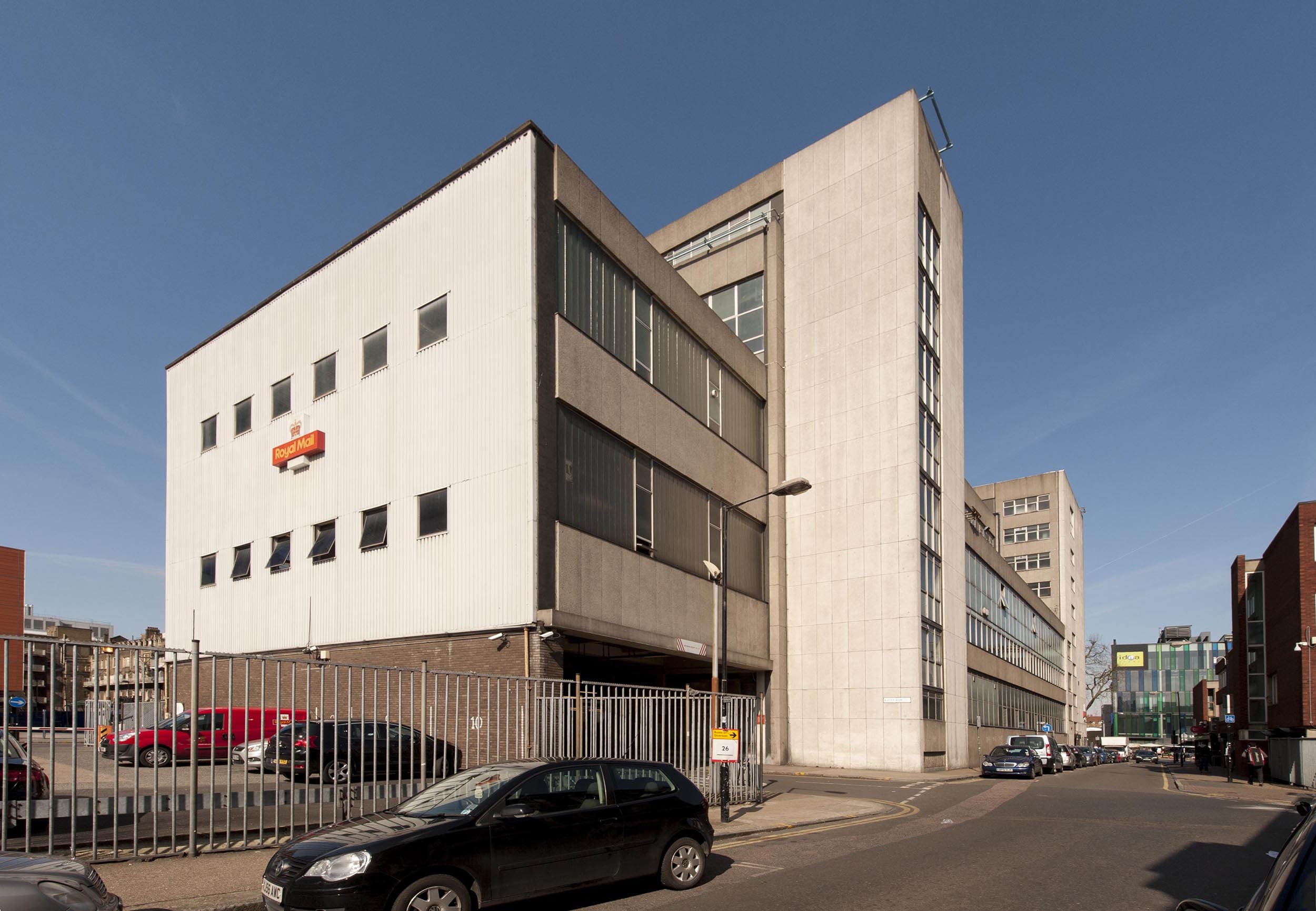
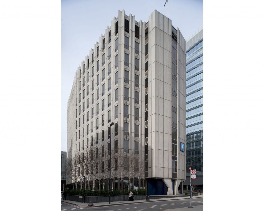
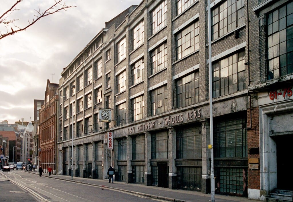
East London Mail Centre, view from Cavell Street in 2016 (© Survey of London, Derek Kendall).

By the 1880s the Eastern District Office had outgrown its premises in Commercial Road and sought land for a chief office with room for expansion. It purchased a piece of former waste ground near the London Hospital, occupied by a paper-stainer’s shop and two cottages. With a 50ft frontage extending south from Whitechapel Road to Raven Row, the site was generous in size and its situation ideal. A new post office was built to designs by Henry Tanner of the Office of Works. It comprised a three-storey red-brick range with a public office fronting Whitechapel Road, and a single-storey sorting office at the rear. The main elevation of the public office was grand in character, with a central pedimented gable and round-arched windows on the third floor. In contrast, the sorting office presented a robust brick elevation to Cavell Street, with a plain staff entrance and large recessed windows.

Rapid growth in demand for postal services sparked plans to extend the building to relieve ‘cramped’ working conditions. By 1899 the number of letters processed at the Eastern District Office had increased twofold. Ground to the west of the building was acquired and a significant extension built to designs by Jasper Wager of the Office of Works, which nearly doubled the floor area. Further alterations followed with the construction of the Post Office Railway, or ‘Mail Rail’, to plans by William Slingo, engineer to the General Post Office, and Harley H. Dalrymple-Hay, consulting engineer. The underground electric railway was conceived in 1911 as a solution to the strain on London’s postal services caused by traffic congestion and a soaring volume of letters and parcels. It opened in 1927 to connect all of the capital’s major post offices, with its eastern terminus at Whitechapel. The line approached from Liverpool Street, following the route of Whitechapel Road before curving southwards to meet the station platform and terminating in a loop to the south of Raven Row. Although the railway was closed in 2003, the infrastructure survives and has attracted proposals for reuse.

Map of the Post Office Railway in 1937 (British Postal Museum and Archive catalogue)

IMG_6274

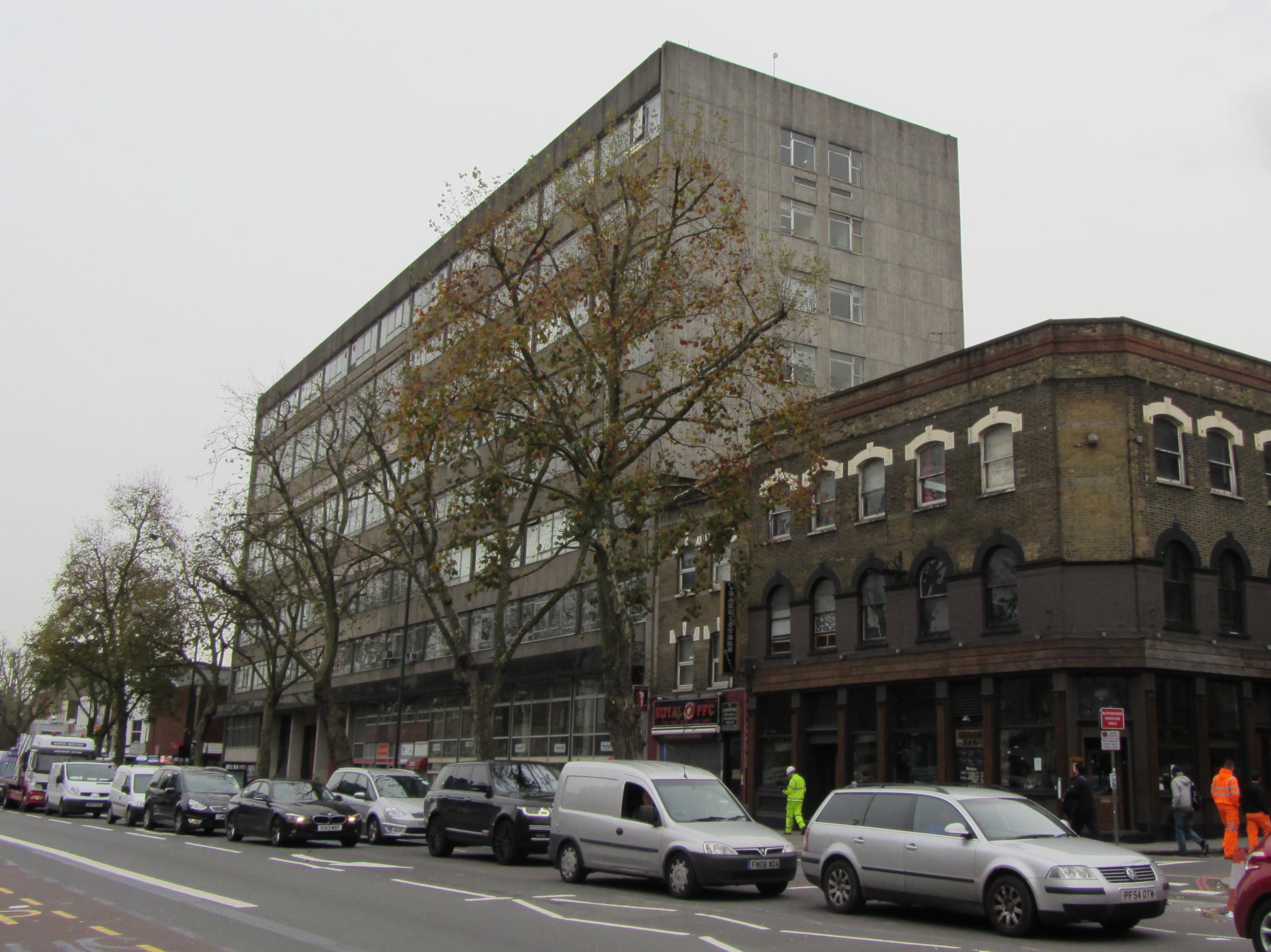
East London Mail Centre, north elevation overlooking Whitechapel Road.

The introduction of mechanised postal sorting equipment in the 1930s led to new requirements for sorting offices and Whitechapel Road’s was probably considered unsuitable for modernisation. A scheme for redevelopment of the site seems to have been in place by 1956, when plans indicate that the adaptation of the former clothing factory on the east side of Cavell Street for post-office use was considered, most likely as an interim measure. The acquisition of Nos 180–188 Whitechapel Road and the adjacent builder’s works provided a substantial site with a frontage of over 200ft.

The earlier buildings were demolished and the present Modernist building constructed in two phases by 1970. The first phase comprised the eight-storey west block, which housed a ground-floor public post office with administrative offices above. It was followed by the adjoining four-storey sorting office, which extends along Cavell Street to Raven Row. The drab utilitarian exterior was the product of a short-lived initiative to standardise the design of post office buildings, in a new house style showcased in a 1960s exhibition produced by the architects’ department of the Ministry of Public Building and Works, headed by Eric Bedford. The main elevation facing Whitechapel Road is divided into eleven bays clad with prefabricated-concrete panels and horizontal bands of glazing. The structural frame of the building is exposed on the ground floor by four concrete columns flanking the van entrance to the sorting office. The widely publicised ‘modular system’ was contrived as a ‘common approach’ to building design to make post offices ‘instantly recognisable in any setting’.

Photograph of a model of the Eastern District Office (BPMA catalogue)

ghfhfghf

Van entrance to the former sorting office, flanked by open concrete shafts.

The interior of the sorting office was laid out for a mechanised workflow, which processed four million items each week. The ground floor functioned as a loading yard, with large entrances for postal vans opening onto Whitechapel Road and Raven Row. A warren of chutes and conveyors enabled the flow of letters, parcels and mail bags between stages in the sorting process. A chain conveyor brought inward mail bags from the yard to the sorting floors, to be processed by specialised machinery. The first, second and third floors of the sorting office comprised open-plan rooms with continuous steel-framed windows on each exterior wall to maximise light provision. Offices for inspectors were formed from light partitions. The Eastern District relied on over 2,000 postal staff working through the day and night, and a lounge, games room and bar were provided on the fourth floor.

Isometric plan of the basement, ground floor, first floor and mezzanine (BPMA catalogue)

Isometric plan of the second, third and fourth floors (BPMA catalogue)

The East London Mail Centre did not survive plans announced in 2000 to modernise London’s sorting system and, at the time of writing (2016), its former offices are occupied by tenants and only a modest delivery desk continues to operate. As the site has been earmarked for redevelopment by Tower Hamlets Council, the building is likely to be demolished.

The Survey of London has launched a participative website titled ‘Histories of Whitechapel’. Please visit at https://surveyoflondon.org.

White Church Lane, Whitechapel

By the Survey of London, on 21 October 2016

White Church Lane is a last redoubt of Whitechapel’s rag trade, still (or until very recently – it’s hard to be up-to-the-minute) sporting shopfronts pertaining to manufacturers and wholesalers: Tip Top Casual Wear, K. K. Hosiery Ltd, Raw Blue Ltd, N.E.W.S. Urban, Mekyle (Bayfield Trading Ltd), Denim World, Alish (wholesale jewellery and accessories), HIP HOP Collections (wholesalers of American street wear), Senior Style Ltd, Abraham Posh Lady London. There is also an efflorescence of street art, work from 2012 facilitated by Global Street Art’s negotiations with property owners.

The road’s origins are as the north end of Church Lane, the only north-south route through the parish, in existence by the seventeenth century to link Well Close to Whitechapel High Street. The northern stretch may not have been much built up until the 1660s and back building suggests density and low status – Church Rents or Maidenhead Court (later Dyer’s Yard), and Hatchet Alley (later Spectacle Alley, now Whitechurch Passage) which had Adam and Eve Court on its south side, and there was Back Yard off the lane’s west side. All this had gone by 1800. Eighteenth-century property holders included Joel Johnson, the carpenter and architect who worked on local churches and the London Hospital. There was a sugar house near the north end and the Fir Tree public house was at the south end of the east side, adjacent to a site taken in the 1840s for John Furze’s St George’s Brewery (subsequently Johnny Walker’s St George’s Bond, now Hult International Business School). The north end of Church Lane’s east side was redeveloped in the early 1850s and the south end was obliterated by extension of the Commercial Road in 1869–70. Redevelopment since has been piecemeal, with a central section of the east side replaced in 2000-2 by the Naylor West flats, designed by Michael Squire and Partners for Ballymore Properties. That block’s artless greyness was a herald of cleansing, and sites at the street’s south end on both sides are now destined to host tower-block flats.

Survey of London - Whitechapel Volume 4-8 White Church Lane, Whitechapel. View from west. 4-8 White Church Lane, buildings of the 1850s with street art of 2012 (© Derek Kendall).

4-8 White Church Lane, buildings of the 1850s with painted shutters of 2012 (© Derek Kendall, 2016).

The north end of the street’s east side is anchored by what was St Mary’s Clergy House, now a Japanese restaurant, a building of 1894–5, Herbert O. Ellis, architect, that was an adjunct to the parish church that stood on the site of Altab Ali Park (see blog post of 15 April 2016). Next door, No. 4 of 1852–3 was built to be a sale room for Isaac Bird, auctioneer. Hunto has painted its shutter. A workshop behind an entrance passage at No. 4A was built in 1899–1900 for William Nay, a mirror manufacturer, and converted to be a necktie factory in the 1920s. The front-door shutter has a figure by Tizer. Next door at No. 6 the shutter art is by 2Rise, whose tag has also been prominent on the south side of Whitechurch Passage. Nos 8 and 10 were built in 1852 by Jabez Single of New Road, houses with shops first occupied by Mark Berry, a zinc and tinplate worker, and James Fullerton Barber, a printer. Alterations and extensions to the rear were made for a bedding factory that was later a silk-screen and joiners’ workshop. Dining rooms at No. 12, run by Alfonso Pappalardo in the 1930s, were held from the early 1940s to the early 1950s by Narian Singh for one of the area’s first Asian-run restaurants. At the time Bonn & Co Ltd had a large biscuit warehouse behind Nos 16–32.


P1180491 adjusted

Kirstein Mansions, 34-40 White Church Lane, shops, tenements and workrooms of 1911 built for Solomon Kirstein (© Derek Kendall).

Solomon Kirstein’s letterhead, showing 29 Commercial Road (Tower Hamlets Local History Library and Archives, Building Control file 41978) and Kirstein Mansions, 34-40 White Church Lane, shops, tenements and workrooms of 1911 built for Solomon Kirstein (© Derek Kendall, 2016).

A house and shop at No. 34 were the premises of Henry Bear, a tobacco manufacturer here from the 1840s to the 1880s. He acquired the freehold of the buildings on the sites of Nos 34–40 and an empty site at 29–31A Commercial Road and in 1901 a lease was transferred to Solomon Kirstein, a printer based at No. 38. By 1902 Kirstein had built three three-storey houses or workrooms with shops at Nos 29–31A, with Herbert O. Ellis as his architect. Kirstein took the shop at No. 29, living above with his wife, three children and a servant. It was not until 1911 that Kirstein redeveloped his Church Lane frontage as Kirstein Mansions, shops, tenements and upper-storey workrooms, this time with John Hamilton & Son, architects. Around 1970 David Abraham began selling knitwear at No. 34. In 2015 the David Abraham Partnership put forward a redevelopment scheme for the whole site proposing a seventeen-storey tower designed by Stock Woolstencroft.

Survey of London - Whitechapel Volume 3 White Church Lane, with embellishments of 2012 (© Derek Kendall).

3 White Church Lane, with embellishments of 2012 (© Derek Kendall, 2016).

On White Church Lane’s west side a small bomb-damage replacement building of c.1960 at No. 3 was decorated in 2012. The entrance-door shutter has wings by Probs, and the south return to Whitechurch Passage a head by Hunto and ‘The Lady’, a low-relief ceramic by ChinaGirl Tile.

Survey of London - Whitechapel Volume Whitechurch Passage, Whitechapel. Wall art of old woman raking up money, by artist "China Girl."

‘The Lady’, by ChinaGirl Tile (© Derek Kendall, 2016). 

Further south, first-floor blind arcading in a little-altered stock brick front at No. 17 was built around 1840 for Charles Marshall, a veterinary surgeon who probably dealt largely with horses. The shop is infill of what was an open carriageway into the twentieth century. Stables to the rear were rebuilt for Marshall’s successors. Around 1880 Simon Cohen, a pastry cook based at No. 32 across the road, established a refuge for homeless immigrant Jews in a house at No. 19. Named the Poor Jews’ Temporary Shelter, its  closure as insanitary in 1885 led to fundraising that permitted the establishment of better premises on Leman Street. Other properties continued to be used as ad hoc refuges or lodging houses. In late 1885 a Shelter employee took five immigrants from Brest-Litovsk to 11 Church Lane, then occupied by Paul Meczyk, a printer, only for them to be turned out on to the street. By 1891, in which year he fell out with the Shelter Committee, Cohen had converted the house at No. 19 to be a ‘Beth Hamedresh’ (Study Circle and Synagogue). He acted as his own builder and carried out further works in 1895–6. But this did not last. In 1898–9 Jacob King redeveloped the site with 9 Manningtree (formerly Colchester) Street; Arthur C. Payne was his architect. On the corner (No. 21) there was a Horse and Groom pub by 1760. The two-storey pub that had been run by Henry Levy was rebuilt for King in 1902 to designs by Ralph J. Miller, architect. It was a Truman, Hanbury & Buxton pub by 1910.

Survey of London - Whitechapel Volume 29 Commercial Road at junction with White Church Lane, Whitechapel. View from east.

19-37 White Church Lane and 27 Commercial Road, demolished 2016 (© Derek Kendall, 2016). 

Fishel K. Abrahamson converted a house at No. 29 to be a synagogue in 1895–6, and nineteenth-century houses at Nos 35–37 were part rebuilt and perhaps refronted in 1915. The four-storey corner warehouse that was 27 Commercial Road had been built in 1872–3 and more warehousing went up to its west in 1876–8 at No. 27A which accommodated Hyam Goldstein’s cap factory, then Aaram Bagel’s boot factory, Burstein Isaac & Co.’s cigarette factory, and tea packing. Nos 29–33 Church Lane and 27A Commercial Road were redeveloped in 1936–7, with George Coles as architect for M. Freedman, a gown manufacturer. Coles is best known as a cinema architect, and there was a faint echo of his Art Deco skills in the façade fenestration of the factory and showroom block. Shutter painting of 2012 here was by Malarky, Chase and Billy. A scheme for redevelopment of Nos 29–37 and 27–27A Commercial Road was prepared in 2012, approved in 2014 and refined in 2016 prior to clearance of the whole site, now complete. Plans initiated by Reef Estates Aldgate Ltd propose a 270-bedroom hotel in a 21-storey tower to be operated by Motel One, a German firm. The architects are Stock Woolstencroft.

The Survey of London has launched a participative website titled ‘Histories of Whitechapel’. Please visit at https://surveyoflondon.org.

The Church of St Mary Matfelon, Whitechapel: part two

By the Survey of London, on 1 July 2016

In 1873 an inspection in advance of an intended redecoration led to a condemnation of the seventeenth-century church of St Mary Matfelon as structurally unsafe (see earlier post). The parish reluctantly geared up to spend £4,000 on essential repairs. Then, in June 1874, Octavius Edward Coope came to the rescue. Coope was a wealthy brewer, a founder of Ind Coope & Co. in Romford in 1845, which firm expanded to Burton-on-Trent in 1856. He had been an MP in 1847–8, but was unseated on grounds of bribery. After a long interval he was again elected to Parliament as a Conservative MP for Middlesex in 1874. With that newly acquired status, Coope stepped forward claiming to be a Whitechapel parishioner – Ind Coope & Co. had offices and a depot on the west side of Osborn Street. Coope himself lived in Essex and, when in London, on Upper Brook Street in Mayfair. He offered to pay up to £12,500 towards a new church, presenting plans by his architect nephew, Ernest Claude Lee, who had been a pupil of William Burges’s, for a red-brick and stone-dressed High Gothic Revival building to seat 1,400. The offer was initially accepted with great relief and joy, but Coope had soon to defend the proposed use of red brick, averring, wrongly, that ‘our great church architect Street invariably uses it’. [1] In fact, for comparative inspection a Vestry committee turned to James Brooks’s recent red-brick churches in Haggerston, St Columba and St Chad. This committee was led by the Rev. James Cohen, a converted Jew who had been Whitechapel’s rector since 1860; it was subsequently spearheaded by Augustus William Gadesden, a sugar refiner. They were not impressed, convinced in their dislike of red brick, and anyway keen to have a larger church. Overall costs were estimated to be about £6,000 more than Coope was offering. Cohen’s committee concluded in September, with diminished alacrity, that ‘it is expedient that the offer of Mr Coope be accepted.’ [2] Rebuilding began in 1875 when Cohen was succeeded by the Rev. John Fenwick Kitto. Work was completed in October 1876 and there was a consecration in February 1877. The upper stage of the tower and spire followed in 1878. The estimated total final cost had risen to about £30,000 of which it was later said around £10,000 came from public subscription, the rest from Coope.

The Church of St Mary Matfelon was rebuilt with a tall spire in 1875-8, but it had to be largely rebuilt again after it was burnt out in 1880 (The East of London Family History Society, reproduced via Wikimedia Commons).

The large brick church comprised a nave and aisles, a round-apsed chancel, a baptistery under a west gallery and a three-stage north-west tower with an octagonal spire and corner turrets rising 175ft in all, sited so as to be prominent on the main road. It extended further west and south than had its predecessor and was set less squarely to the road, to minimise disturbance of the graveyard and avoid southerly ground that was only leasehold. While adhering to red brick, Lee had amended his plans. The church had only 1,250 sittings and omitted a full-height north transept in favour of a gabled organ bay at the east end of the north aisle. An unusual feature, reflecting the local evangelical mission, was an external pulpit, placed on a staircase turret at the north-west corner of the nave. There was a large ‘church room’ to the south-east in which relics from the old church were displayed. The interior had ornamentally carved Bath stone dressings to naked brick surfaces (perhaps intended for decoration), Minton floor tiles and a ceiled wagon-vault, a form chosen for auditory reasons, ill-advisedly as the building had very poor acoustics. The old clock and bells were reset. Lee deployed thirteenth-century style details and himself designed fittings including the pulpit, lectern, font and a mosaic apse floor, executed by Burke & Co. of Regent Street. Horatio Walter Lonsdale, Lee’s brother-in-law, supplied stained-glass windows. Stone carving was by Thomas Earp of Lambeth.

 View of the interior of the 1876 church, looking towards the chancel (Building News, 8 September 1876).

View of the interior of the 1876 church, looking towards the chancel (Building News, 8 September 1876).

This church was short-lived, suddenly gutted by fire on a summer’s Thursday afternoon, on 27 August 1880. Flames in the organ chamber swept up the organ pipes into the timber roof. The tower survived. Kitto and Gadesden led an approach to Coope, still an MP, who undertook to use his influence to secure insurance cover of £16,800 and to stump up further rebuilding costs. The acoustical shortcomings of the destroyed interior led him to make replacement conditional on a redesign by nephew Lee. The church was rebuilt in 1881–2 on the same plan, but with a polygonal apse and an open pseudo-hammerbeam roof beneath a lower ridge which did bring acoustical success. The nave west wall was given three windows in place of two, and there were other detailed variations that favoured a style more characteristic of the fourteenth century. The interior was yet more richly sculpted than its predecessor, and this time lavishly decorated with stencilling that shows the influence of Burges. Lonsdale supervised painting and glass.

St Mary Matfelon, 9-5-1941, HELR F237

The church was gutted by firebombs in 1940 (Historic England London Region).

An alabaster reredos intended since 1878 was at last made in 1886–7 as a memorial to Coope. Carved by Earp, it represented the Last Supper and the Tree of Jesse, and stood in front of stencilled decoration of the early 1880s by Lonsdale that included large angels for the Twelve Gates of the Heavenly Jerusalem.

Rebuilds notwithstanding, church attendance declined. It was estimated in the early 1880s to be around 1,500 across Sunday services, the main impediment being what the Rev. Arthur James Robinson called ‘the old story of indifference’. [3] Yet this was among the best attended of East London churches, with fully choral services and psalms chanted morning and evening. By 1884 Robinson’s team included two Missioners to Jews, the Rev. J. H. Bruhl and the Rev. A. Bernstein. The open-air pulpit was in regular use, and by the 1890s and well into the twentieth century special services were conducted for Jews in Hebrew and German, with sermons preached in Yiddish to congregations of up to 500. A last notable rector was the Rev. John A. Mayo, who gave the first ever radio sermon in 1922.

St Mary’s Church was gutted once again, this time by fire bombs on 29 December 1940. The ruined shell of the building was cleared in 1952.

St Mary Matfelon, 9-5-1941, HELR F238

Nave of the church in 1941 after bomb damage (Historic England London Region).

References

  1. Tower Hamlets Local History Library and Archives, L/SMW/A/1/1
  2. THLHLA, L/SMW/A/1/1
  3. Lambeth Palace Library, FP Jackson 2, f.513

The Church of St Mary Matfelon, Whitechapel: part one

By the Survey of London, on 10 June 2016

The first church on the site that is now Altab Ali Park was built in the mid thirteenth century, dedicated to Mary and from the outset identified as ‘de Matefelun’. This, which became Matfelon, may derive from a family name; Richard Matefelun, a wine merchant, is said to have been present in the area in 1230. If this is the derivation (matfelon as meaning knapweed is the least preposterous of numerous suggested alternatives), it was presumably in recognition of a pious benefaction, maybe prompted by local need. There was significant population growth in the area, and the existing parish church of St Dunstan, Stepney, was distant.

Archaeological evidence indicates that the church was of clunch or white chalk rubble. It thus, no doubt, came to be known as the ‘white chapel’, an appellation in use by 1344. Clunch was not uncommon in medieval churches, especially east and north of London, but it is friable so was often mixed with other materials. The church was reportedly wrecked in a storm and restored in 1362 thanks, it is said, to a papal Bull negotiated by the absentee rector, Sir David Gower, a Canon of St Patrick’s Cathedral, Dublin, that promised sinners a remission of penance for visiting Whitechapel with an offering. There were four priests in 1416 indicating a large congregation or at least a prospering parish. Documentation of legacies and archaeology both point to fifteenth-century improvements, to doors and windows if not more. Exceptionally, there were no chantries at the Reformation, when, in 1548, there were 670 communicants.

View of the 1670s church (Reproduced by kind permission of Tower Hamlets Local History Library and Archives).

View of the 1670s church (Reproduced by kind permission of Tower Hamlets Local History Library and Archives). If you are having problems viewing images, please click here.

Little is known of the form of this medieval church. It appears to have had a four-bay nave to which a three-stage tower and a north aisle and porch might have been fifteenth-century additions. A south ‘aisle’ was added in 1591. This was, it seems, separately roofed, and almost as tall as the nave. More a room than an aisle it would have generated not just more seating for a growing congregation, but also a more auditory and less processional interior. That would have been in keeping with the Calvinist conventions of the late sixteenth century that were strongly represented in east London, where Protestantism sparked early. These norms were firmly upheld by Richard Gardiner, Whitechapel’s rector from 1570 to 1617. Prominent among Elizabethan puritans, Gardiner was embroiled in high-level religious–political controversy in the immediate run up to the extension of his church in 1591. Tellingly, during his time the vestry sold off the church organ.

In 1618 William Crashawe, another outspoken and leading London puritan, became Whitechapel’s rector. He oversaw the insertion of a gallery in the south aisle which suggests that capacity was already again stretched. It bore a panel to celebrate the failure in 1623 of the Spanish Match. Crashawe died in 1626, preceded by 1,100 of his parishioners in the plague year of 1625. His successor in what his will called the ‘too greate Parishe’ of Whitechapel was John Johnson, another puritan, but one who married the daughter (Judith Meggs) of a wealthy parishioner in 1627 and trimmed thereafter to align with the anti-Calvinist tide headed by Bishop William Laud. Johnson moved the communion table to the east end of the church, and undertook beautifying repairs in 1633–4 with £300 raised from parishioners and more from the Haberdashers’ Company, which in making the grant took into account the relative poverty of the parish.

Laud had strong local opposition and Johnson was among the first London clergy to be deprived of his living in 1641. Thomas Lambe’s General Baptists, formed in Whitechapel at this time, were ‘easily the most visible and notorious of all sectarian congregations in London’. [1] After contested elections for parish overseers and violent confrontations in the church in 1646, Whitechapel’s Independents gained control and gathered under a new rector, Thomas Walley. When the tables turned at the Restoration in 1660 Johnson was reinstated and a schism resulted, most of the congregation departing to a meeting house in Brick Lane. In 1662 Walley was arrested preaching elsewhere in Whitechapel; he soon after emigrated to New England. Johnson was revealed as corrupt and deprived of his living in 1668, chiefly through the agency of his son-in-law, Ralph Davenant, who became Whitechapel’s next rector. A fellow of Trinity Hall, Cambridge, and a descendant of Bishop John Davenant, the moderate Calvinist who had represented the English church at the synod of Dort in 1618, he was also a cousin to the historian Thomas Fuller.

Plan of the Church of St Mary Matfelon, Whitechapel, as rebuilt in 1672-3.

Plan of the Church of St Mary Matfelon, Whitechapel, as rebuilt in 1672-3 (© Historic England).

Under Davenant the largely medieval church was rebuilt in 1672–3. The principal benefactor was William Meggs, who had the parish’s largest house where Johnson, his brother-in-law, had lodged in the 1650s. Meggs had been a member of Johnson’s vestry from 1660. These links with Johnson notwithstanding, Crashawe’s panel of 1623 was relocated onto the new south gallery and a monument to Crashawe himelf was conspicuously re-erected on the north wall. Puritan inheritance was not obscured.

In its architectural form the new brick-built church represented a rapprochement with moderate Nonconformity. It reused some old footings and lower parts of the tower, but in its regular cross-in-rectangle plan with shallow transept projections, it closely followed pre-Restoration Calvinist models at Westminster Broadway and Poplar (now the Church of St Matthias). While architects and builders remain unknown, there are circumstantial reasons for suspecting involvement on the part of Robert Hooke. The assuredly, if impurely, classical auditory interior was light and spacious. Though centralized, it had an east-west axis emphasized by three ribbed cross vaults supported by Portland stone Corinthian columns. There was a step up to the chancel, otherwise only articulated by the inclusion of flanking vestries. Shallow north and south galleries were probably original.

Davenant was succeeded in 1681 by Dr William Payne, a latitudinarian, fellow of the Royal Society and leading Whig among London clergy who was keen to embrace dissenters. The liturgical politics of Whitechapel changed dramatically in 1697 with the appointment of the Rev. Richard Welton, a high-church Tory and Jacobite. Welton attacked Nonconformity and spurned the area’s recent Huguenot immigrants: ‘This set of rabble are the very offal of the earth, who cannot be content to be safe here from that justice and beggary from which they fled, and to be fattened on what belongs to the poor of our own land to grow rich at our expense, but must needs rob us of our religion too.’ When this was quoted by G. Reginald Balleine in 1898 he added ‘how blind this prejudice was … May we learn the obvious lesson for ourselves!’. [2] Harking back to the Laudian spirit, Welton made beautifying alterations, moving the font and altering pews, and attracted controversy in 1713 when he placed a painting of the Last Supper by John Fellowes in the church as an altarpiece. Judas was prominently represented as a likeness of Bishop White Kennett, an antagonist of Welton’s. Through the Bishop of London, Kennett saw to the altarpiece’s removal in 1714. The same phase of works included an organ by Christopher Schreider, perhaps also the west gallery in which it stood. The organ case was later described as ‘carved and gilt, with carved oak trusses and gilt cherubim, surmounted by four richly-carved and gilt figures’ [3] The gallery front sported a finely carved wood panel depicting King David playing the harp flanked by musical instruments. This survives close by in the church of St Botolph Aldgate. Refusing to swear loyalty to the Hanoverian succession, Welton was deprived of his position in 1715.

A few fragments from the churches survive, including this carved wood panel of King David with music instruments that was made to grace the front of an organ gallery in 1713-15, now close by in St Botolph Aldgate

A few fragments from the church survive, including this carved wood panel of King David with musical instruments that was made to grace the front of an organ gallery in 1713-15, now close by in St Botolph Aldgate.

Under a succession of latitudinarian rectors Whitechapel’s church appears to have steered clear of further controversy making it a quieter but duller place. It was repaired and beautified in 1735 and again repaired, in what was a wealthy parish, with funds raised through an Act of Parliament in 1762–3 when the tower, possibly unstable, was to have been cased in Portland stone – it was probably rendered instead. The clock stage gained aedicules and a large cupola took the place of a small bell turret. Similarities with the exactly contemporary St George’s German Lutheran Church on Alie Street suggest that the carpenter–architect Joel Johnson may have been in charge of this project. He had property, perhaps a home, round the corner on what is now Whitechurch Lane.

There were further expensive repairs in 1805–6, with James Carr as surveyor. Structural rescue involving iron tie rods followed in 1825–6, with John Shaw (the elder) the surveyor this time. Even so, the tower became dangerous. James Savage acted as surveyor for yet further repairs in 1829–30. In 1839 Edward Blore reported on the state of the church and recommended rebuilding. Discussion was adjourned for a year, but not resumed, the notion presumably deemed too costly.

From 1837 to 1860 the Rev. William Weldon Champneys was Whitechapel’s rector. An evangelical, he started with a congregation of about 100, in a population of 36,000, and by 1851 had built attendances up to more than 4,000 across three services on a Sunday. He brought numerous reforms to Whitechapel, from a Sunday School and Mothers’ Meeting, to a Coal Club and Shoe Black Brigade, attempted to convert Whitechapel’s many Jews, and battled cholera and house farmers. Champneys also divided the parish, founding three new churches.

The tower was again and for the last time repaired in 1865. The subsequent history of the church will follow in a second post.

References

[1] Murray Tolmie, The triumph of the saints: the separate churches of London, 1616–49, 1977, p.76

[2] G. Reginald Balleine, The Story of St Mary Matfelon, 1898, p.22

[3] The Builder, 30. Jan. 1875, p.93

Altab Ali Park, Whitechapel

By the Survey of London, on 15 April 2016

On 4 May 1978 Altab Ali, a 25-year old clothing machinist of Bangladeshi origin, was murdered in Adler Street, Whitechapel, beside the park that was then called St Mary’s Gardens, a name that recalled the Church of St Mary Matfelon (the medieval ‘white chapel’) which had stood on the site until 1952.

fgdfgd

Altab Ali Park was named in 1994 in memory of a young man murdered near by in 1978 in a racist attack (© Jim Linwood, photo reproduced without changes under a Creative Commons attribution licence). If you are having problems viewing images, please click here.

This attack galvanized resistance to racism in the area and beyond. A decade on, Tower Hamlets Council commissioned David Petersen, an artist–blacksmith, to make the park’s wrought-iron gateway arch to commemorate victims of racist violence. Put up in 1989 at the park’s Whitechurch Lane corner, it playfully combines Bangladeshi and Gothic ornamental motifs. Following a local campaign, the Council renamed the gardens Altab Ali Park in 1994. Five years later the south-west corner of the park gained a Shaheed Minar (Martyrs’ Monument), a semi-circular concrete plinth with five white steel screens, representing a mother and children, the former to the centre bow-headed in front of a blood-red circle. This is a smaller version of a Shaheed Minar in Dhaka, Bangladesh, designed by Hamidur Rahman, which commemorates activists of the Bengali language movement killed in 1952. Long desired and petitioned for, a Whitechapel monument began to be planned in earnest in 1996, though not at first with this site in mind. The Bangladesh Welfare Association marshalled contributions from 54 organisations and worked closely with the Council. Another copy of the Dhaka monument was made in Oldham in 1996–7. Its designers, the Free Form Arts Trust, were brought in and commissioned to make Whitechapel’s structure larger. Landscaping and the plinth were handled by the Council, and Arts Fabrications made the monument. It was unveiled on 17 February 1999 by Humayun Rashid Choudhury, Speaker of the Bangladeshi Parliament.

DP179974

The Shaheed Minar (Martyrs’ Monument) was erected in 1999 as a smaller replica of a memorial to nationalist student activists in Dhaka, Bangladesh (© Historic England, Lucy Millson-Watkins, photographer).

Further landscaping followed in 2002 with a new diagonal path through the churchyard that bore an inscription of part of a poem by Rabindranath Tagore, ‘The shade of my tree is offered to those who come and go fleetingly’. The lettering disappeared when another relandscaping of Altab Ali Park was undertaken in 2011. The layout that followed was designed by muf architecture/art as ‘a matrix of the religious and the secular’, [1] and celebrated as ‘a grand collage’. [2] It includes a raised green terrazzo walkway and bench that marks parts of the outline of the site’s Victorian church. Stone fragments carved by apprentices at the Building Crafts College were scattered to suggest the lines of the preceding church. Further south, hillocks, boulders and tree stumps articulate the land east of the Shaheed Minar and, with a small platform, open up a longer view of the monument.

Whitechapel’s churchyard, which has its origins in the thirteenth century, had been walled round and made more or less co-extensive with the present-day park by the 1720s – the eastern part was occupied by a rectory and its private garden. Notable burials in the churchyard included those of Richard Brandon in 1649, said to have been the executioner of Charles I, and Sir John Cass in 1718. The burial ground came to be badly overcrowded and in 1846 its appearance was said to be ‘very far from creditable to the parish’. [3] It was planted with trees and shrubs in 1850–1 under the supervision of Samuel Curtis (who had landscaped Victoria Park), and burials ceased in 1854. A record from 1875 lists 87 gravestones and monumental slabs in the churchyard. These have since been largely removed or tidied to the site’s edges, a notable exception being a chest tomb for the Maddock family (local timber merchants), a stout early nineteenth-century monument of Portland stone with a marble armorial panel. This remains in place in what was the south-east part of the churchyard.

The Maddock family's late-Georgian chest tomb is a reminder that the site was a churchyard (Survey of London)

The Maddock family’s late-Georgian chest tomb is a reminder that the site was a churchyard (© Survey of London). 

The drinking fountain that now faces Whitechurch Lane was originally on the Whitechapel Road, put up in 1860 ‘from one unknown yet well known’, as it is inscribed, perhaps a reference to the Rev. William Weldon Champneys, Whitechapel’s long-serving and reforming rector who left the parish in that year. Early for a public drinking fountain, it has a Norman arch with pink granite colonettes and back panel set in a gabled ragstone surround. The form of the central motif closely followed the example of London’s first free drinking fountain, put up at Snow Hill in 1859 to great public acclaim. The larger Whitechapel fountain was moved round to Church Lane in 1879, then in 1894 moved again a bit further north to make way for the red-brick building at 2 Whitechurch Lane, formerly St Mary’s house, which was built to house the parish clergy, and now houses a Japanese restaurant. A K2 telephone kiosk was placed to the fountain’s right around 1927 and a K6 kiosk followed in the 1930s. The former remains in place.

Whitechapel's drinking fountain of 1860, moved later in the nineteenth century (Survey of London)

Whitechapel’s drinking fountain of 1860, moved here later in the nineteenth century (© Survey of London).

Rebuilding of the church in the 1870s presented an opportunity to widen the adjacent stretch of Whitechapel Road, so in 1878 a (still existing) stone-coped red-brick boundary wall went up along a new setback line. It was designed by the church’s architect, Ernest C. Lee, using Suffolk bricks identical to those he had used to face the church. Two former entrances from the Whitechapel Road are now blocked, the larger one still marked by remnants of stone steps.

When the churchyard wall was built it was proposed that tombstones and human remains should be moved to allow part of the grounds to be an ‘ornamental garden’. [4] This objective was achieved in 1885 when the Metropolitan Public Gardens Association assisted in opening the churchyard to the general public as gardens with an improved layout, seats and a caretaker. There was an entrance charge of a penny. But public use was not sustained and in 1938 proposals for reviving the public garden were blocked by the Rev. John A. Mayo who was concerned that the churchyard would ‘become the resort of undesirable characters’. [5]

The church and rectory were bombed out in 1940. Once the ruins had been cleared, and with the unfenced land indeed attracting uses that aroused criticism, the London County Council set out in 1957 to buy the churchyard to be a public open space, preparing a scheme for planting and landscaping. Legal delays as to title meant that it was 1966 before St Mary’s Gardens could be opened. The lines of the seventeenth-century church were set out in concrete blocks flush with the ground. First intentions had been to mark the medieval ‘white chapel’, but without funding for archaeology this proved impossible. Future posts will describe the history of the church.

On 4 May 2016, Tower Hamlets Council launched Altab Ali Commemoration Day as an annual event.

The park is the site of the church of St. Mary Matfelon, the medieval 'white chapel' (Historic England)

The park in 2011 when blocks delineated the location of the seventeenth-century church of St. Mary Matfelon (© Historic England).

References

[1] Building Design, 11 March 2011, p.4
[2] London Evening Standard, 16 Nov. 2011
[3] The Builder, 15 Aug 1846, p.388
[4] The Builder, 3 Aug. 1878, p.812
[5] East London Observer, 3 June 1939

Whitechapel

By the Survey of London, on 22 January 2016

This blog post is not a history of a site, nor is it like its predecessors about Marylebone or Oxford Street. It is about the Survey of London’s other major current study area, the parish of Whitechapel. This project is still in its early days, so it is too soon for us to be able to offer researched and considered new insights into the area’s architectural history. However, a blog post is an opportunity to keep readers informed of progress, to add to what is on the project’s page on our website.

(© Historic England, Lucy Millson-Watkins)

Altab Ali Park in 2015 (© Historic England, Lucy Millson-Watkins). If you are having trouble viewing images, please click here.

As is explained there, a major new departure for the Survey is being enabled by a significant Arts and Humanities Research Council grant. Starting this month, Dr Duncan Hay, based in the Bartlett’s Centre for Advanced Spatial Analysis with Dr Martin Zaltz Austwick, is working on building an interactive map-based website that when launched in late 2016 will permit public co-production of histories of Whitechapel’s buildings and sites for synthesis by the Survey of London. We are also benefiting from the participation of two research fellows, Shahed Saleem, the architect-author of the first major history of English mosques (forthcoming from Historic England), and Dr Shlomit Flint Ashery, a demographer who is deeply familiar with Whitechapel. Shahed and Shlomit will both facilitate public engagement and further study the area’s recent history. We are also about to employ an archivist for a six-month period to catalogue Whitechapel material at Tower Hamlets Local History Library and Archives ranging from seventeenth-century property deeds to twenty-first century Building Control records. This new catalogue will be accessible to all. Another historian will soon be recruited, and Derek Kendall (formerly of English Heritage) will contribute photography. Around the time of the website launch in the autumn there will be a series of public events to promote awareness of the project and its possibilities.

The Royal London Hospital from Whitechapel Road (© Historic England, Chris Redgrave0

The Royal London Hospital from Whitechapel Road (© Chris Redgrave)

Typically for the Survey of London, early research into Whitechapel’s history has comprised systematic trawls through basic sources, such as District Surveyors’ Returns, The Builder, and the minutes of the Metropolitan Board of Works and London County Council. We have also had a great boon in that Derek Morris has generously given us use of his database derived from eighteenth-century Land Tax records, a core source for his Whitechapel 1600–1800 (2011). All this is vital, but, undigested, not the stuff of blogs.

Cass School of Art (© Historic England, Chris Redgrave)

Central House on Commercial Road, home to the Sir John Cass Faculty of Art, Architecture and Design (© Chris Redgrave)

Location-specific research is beginning on some of the area’s major sites: Altab Ali Park (formerly the parish churchyard where the Church of St Mary Matfelon stood through several rebuilds), the Whitechapel Art Gallery, Toynbee Hall and, largest of all, the Royal London Hospital. Warm archival welcomes promise productive investigations. The former hospital buildings are set to become a town hall for Tower Hamlets Council. We are also keeping an eye on other vulnerable sites where change is in the offing, from a terrace of the early 1870s on Vallance Road (see this post on Spitalfields Life), to Maersk House, Central House (for now still home to the Cass) and the East London Mail Centre on Whitechapel Road.

© Chris Redgrave

3-7 Vallance Road, part of an 1870s terrace that has been threatened with demolition (© Chris Redgrave)

We have also benefitted from contact with students. From our position in the Bartlett School of Architecture the Survey of London is pleased now to be involved in teaching. This academic year, for the first time, the Bartlett is offering a Master’s degree titled Architecture and Historic Urban Environments. For this the Survey has been responsible for a module titled Surveying and Recording of Cities. This has been huge fun, and an excellent opportunity to pass on some of our peculiar practices. We are delighted that two of the students, Niki Tsirimpi and Ananthi Velmurugan, chose sites in Whitechapel for special study. Their work on Gwynne House on Turner Street, Half Moon Passage and the former Whitechapel County Court building on Prescot Street that is now Café Spice Namaste, has given our project significant boosts for which we are most grateful.

Maersk House, 1 Braham Street, from the east (© Historic England, Lucy Millson-Watkins)

Maersk House, 1 Braham Street, of 1976, R. Seifert & Partners, from the east (© Historic England, Lucy Millson-Watkins)

For the time being the Survey’s blog will continue to be dominated by Marylebone and Oxford Street, where study is far more advanced. But if you are interested in the history of Whitechapel please watch this space. Much more, of a more particular nature, will follow, later this year and beyond.

The Royal London Hospital from the north-west (© Chris Redgrave)

The Royal London Hospital from the north-west (© Chris Redgrave)

Welcome to our blog

By the Survey of London, on 25 November 2015

The Survey of London provides essential reading for anyone wishing to find out about the capital’s built environment. In its 120-year history the Survey has explored a wide variety of London districts, from Soho, Mayfair and Covent Garden in the West End to Woolwich, Highgate and Norwood in the inner suburbs. In 2013, the Survey of London joined the Bartlett School of Architecture at UCL.

Our detailed architectural and topographical studies are published in volumes, each of which generally covers one parish. Each book describes the evolution of an area, giving a description of its buildings, explaining how they came into being and outlining their significance and historical associations. The text, which is based on original documentary and field research, is profusely illustrated with a mixture of archive images, architectural illustrations, photographs and maps.

Areas covered by the Survey of London

Areas covered by the Survey of London. If you are having difficulty viewing images, please click here.

The volumes are listed on the Survey of London map and access to the online versions of all but the most recent volumes on Woolwich and Battersea is available at British History Online. You can also follow our updates on Twitter and Facebook.

Now we are launching the Survey of London blog. This will provide a pre-publication outlet for stories that come to light during our research and will include our architectural illustrations and photographs.

Elevation drawing and phase plan of Gilmore House, Battersea

Elevation drawing and phase plan of Gilmore House, Battersea (© Survey of London, Helen Jones)

Marylebone

Our most advanced current area of study is a large swathe of the parish of St Marylebone, bounded to the south by Oxford Street and to the north by the Marylebone Road, and stretching from just west of Marylebone High Street to the parish boundary along Cleveland Street to the east. The area is rich in historic buildings and includes some of London’s most celebrated addresses, such as Portland Place, Cavendish Square and Harley Street. As the study has progressed, we have gained fresh insights into the history and significance of many aspects of this built environment. We hope that you will enjoy peeking into the buildings and places that we have explored (sometimes quite literally, with an upcoming fly-through of St Peter’s Church on Vere Street).

Queen Anne Street (Chris Redgrave)

Queen Anne Street in 2015 (© Historic England, Chris Redgrave)

Oxford Street

Only the north side of Oxford Street falls within Marylebone and although we often just cover one side of the street when it is at the edge of a parish, this seemed particularly unsatisfactory in the case of Oxford Street. Here was an opportunity to produce a separate volume on the entire street, recognizing its historical integrity and its importance as Europe’s premier shopping street, a status which it has enjoyed for a remarkable 200 years. The south side has been touched upon in earlier Survey volumes, though not the section in the parish of St George, Hanover Square. But only a selection of buildings were included, and a few of those have since been demolished. With Crossrail and the rebuilding of Tottenham Court Road station, the entire eastern end of Oxford Street is undergoing rapid change. This volume, with, we hope, a companion photographic panorama, will provide a snapshot of the street as it is today and explore its architectural and sociological development.

oxford-street-panorama

Panorama of Oxford Street in 2015, north side from Hanway Street to Tottenham Court Road (© Historic England, Chris Redgrave, Lucy Millson-Watkins and James O. Davies)

Whitechapel

While work is continuing on the editing and production stage of the south-eastern Marylebone volumes, ahead of publication scheduled for November 2016, we are launching a study of Whitechapel. Whitechapel is at the heart of London’s East End and has a multifaceted history that is reflected in its diverse built environment, which includes the Royal London Hospital, the East London Mosque, Toynbee Hall, Wellclose Square and the Whitechapel Art Gallery. Whitechapel is currently in the throes of intense and rapid change due to its proximity to the City; speculative developments are now giving parts of the area a new, glassy and much taller character.

A major grant from the Arts and Humanities Research Council will permit us to break new methodological ground in collaboration with the Bartlett’s Centre for Advanced Spatial Analysis. We will create an interactive website for public co-production of research, tapping into the insights of local communities and others to document experiences and understandings of all manner of places.

As these projects develop, we look forward to sharing stories from our explorations into the history and architecture of Whitechapel and Oxford Street.

Alie Street in c.1999 (Chris Redgrave)

Alie Street in c.1999 (Chris Redgrave)