 Close
Close

Comparing the Differences in Early Warning Systems between Shanghai and Hong Kong: Exploring the Potential for Shanghai and Hong Kong to Improve Early Warning Systems
By Amanda Gallant, on 28 September 2023
By: Zhang, Yue
University of Glasgow
1. Introduction
As two of the most dynamic metropolises in Asia, Shanghai and Hong Kong face significant shared challenges when it comes to managing and mitigating the impacts of natural hazards. Both cities are positioned within regions characterized by heavy summer rainfall making them susceptible to threats such as flooding, typhoons, tropical cyclones, and storms, presenting constant challenges to their infrastructures and populations (State Council Information Office of PRC, n.d.; Michigan State University, n.d.).
Shanghai, strategically located on the Yangtze River Delta, is a city besieged by an array of meteorological hazards. Its low-lying coastal geography, with over half of the city sitting at or below sea level, heightens its vulnerability to phenomena such as storm surges and land subsidence (Zhao et al., 2022; Huang et al., 2022). Further challenges emerge from the city’s rapid urbanization and extensive paving, amplifying the risk of urban flooding during heavy rainfall events (Wang et al., 2020; Xu, 2020).
Meanwhile, Hong Kong’s geographic profile offers a stark contrast. Dominated by mountainous terrain, granite, and easily weathered rocks, along with uneven surface coverage, the city contends with the threat of landslides and flash floods (Chen et al., 2014). The steep inclines and concentrated developments in low-lying coastal areas heighten the city’s exposure to such hazards, particularly during the typhoon season. Furthermore, Hong Kong’s position on the map subjects it to frequent tropical cyclones, capable of causing severe wind damage and flooding (Chen et al., 2014).
Despite their shared regional characteristics and the common risks they face, the responses of Shanghai and Hong Kong to these challenges are far from identical. Each city has developed its own unique hazard warning and response systems, influenced by distinct historical, cultural, and political contexts. This blog will delve into the differences between Shanghai, a major city in mainland China, and Hong Kong, a Special Administrative Region operating under the “One Country, Two Systems” policy. It will explore the effectiveness of these varying approaches, consider their strengths and limitations, and investigate potential areas for mutual learning and improvement. By doing so, we hope to shed light on how these two iconic cities can enhance their resilience in the face of the ongoing threat posed by natural hazards.
2. Background – The History of Warning Systems in Hong Kong and Shanghai
2.1 Hong Kong’s Legacy of Warning Systems
The origins of Hong Kong’s warning systems can be traced back to the 19th century, a time when the city was frequently battered by typhoons. The “Jiaqing typhoon hazard of 1874” was among the most devastating events, triggering a wave of change in the region’s hazard management approach (Bian, 2020). To safeguard public safety, the Hong Kong government inaugurated the Hong Kong Observatory in 1883, which set the wheels in motion for regular meteorological observations. This institution also took the initiative to develop a tropical cyclone warning system utilizing visual signals and incorporated magnetic and astronomical observations into its suite of capabilities (Hong Kong Observatory, 2023).

Time Ball of Tsim Sha Tsui Police Station (1885-1907)
History of Hong Kong Observatory, 2023
Hong Kong’s economic boom between the 1950s and 1970s brought along an array of challenges. During this time, the city’s population doubled, leading to a surge in construction on steep hillsides. With houses being built without professional design or reinforcement, heavy rainfall resulted in frequent mudslides and landslides, transforming Hong Kong into a high-risk zone for such hazards (Keegan, 2022). The unstable mountainous terrain was particularly susceptible to rainwater-induced erosion. The escalating landslide threat took a severe toll on residents’ safety and properties, culminating in hazardous incidents like the Sau Mau Ping Landslide in 1972, which razed 78 squatter huts and claimed 71 lives (CEDD, 2021).

Sau Mau Ping landslide in 1972
(CEDD, 2021)
Reacting to the dire situation, the Hong Kong government established the Civil Engineering and Development Department (CEDD) in 1972 to curb the escalating landslide threat. The CEDD and the Hong Kong Observatory joined forces to issue warnings about potential landslides and flash floods. Fast forward to 2022, Hong Kong now enjoys the reputation of being the world’s first city to design and implement a slope safety system targeting landslide prevention, as reported by the BBC (Keegan, 2022). This government-driven initiative has significantly enhanced slope safety and mitigated landslide risks, setting a global standard in the process.
The period following Hong Kong’s reintegration with China in 1997 saw the region making significant strides in bolstering public safety. The government ramped up investments in the development of sophisticated, technology-driven warning systems. A major breakthrough occurred in September 2007 when the Security Bureau and Emergency Support Unit unveiled the “Natural Hazard Contingency Plan” at the Hong Kong Government Headquarters (Government Headquarters Security Bureau Emergency Support Unit, 2007). Characterized by its detailed division of labor, clear-cut responsibilities, and ease of implementation, this plan cast the Hong Kong Observatory in a pivotal role. The Observatory was tasked with closely monitoring weather conditions, swiftly issuing warnings to the media and relevant departments during adverse weather and providing timely weather updates.
The evolution of Hong Kong’s warning system illustrates the remarkable benefits of strategic investments in hazard prevention and management, which have considerably reduced casualties and property destruction. With its pioneering slope safety system and advanced warning mechanisms, Hong Kong offers a commendable model for international endeavors in hazards management.
2.2 Shanghai’s Meteorological Early Warning System
Shanghai’s meteorological early warning system carries a rich history, stretching back over a century. In 1884, the Shanghai Bund signal tower embarked on the journey of displaying regular meteorological signs, reflecting weather fluctuations to assist ships anchored in the Huangpu River. Flags or balls hoisted on the tower’s mast signaled imminent weather changes. If a typhoon were on the horizon, these signals would provide critical information on the typhoon’s strength, direction, and location, furnishing an early warning (PengPai news, 2022).

Figure 1: The Bund Observatory / Gutzlaff Signal Tower, built in 1907
(PengPai news, 2022; Can Pac Swire, 2011)
Following the establishment of the People’s Republic of China in 1949, significant improvements were made to Shanghai’s early warning system. The Shanghai Meteorological Bureau, founded in 1956, became responsible for weather forecasting. In 2003, the ‘Shanghai Disastrous Weather Early Warning Signal Issuance Regulations’ came into effect. This regulation defined the Meteorological Bureau’s duties in hazard emergency response and prevention, in line with the implementation measures of China’s Meteorological Law (China Meteorological Administration, 2010).
A transformative phase commenced in 2008 when, in response to President Hu Jintao’s call and backed by the China Meteorological Administration and the Shanghai Municipal Government, the Shanghai Meteorological Bureau began working on a Multi-Hazard Early Warning System (MHEWS). The system, constructed on the core principles of “government-led, inter-departmental coordination, and social participation,” zeroes in on key components of hazard prevention and mitigation. These include risk assessment, emergency plan formulation, monitoring and forecasting, warning dissemination, and inter-departmental coordination for meteorological and secondary derivative hazards. The MHEWS’s central goal is to offer timely and precise information to the public and government officials, promoting effective decision-making in hazards scenarios (Tang et.al, 2012).
Shanghai’s meteorological early warning system stands as a testament to the city’s long and evolving journey in hazards management. The launch of the MHEWS marks a significant leap forward in developing advanced, integrated surveillance and response systems that are custom-tailored to the myriad risks Shanghai faces.
Hong Kong and Shanghai’s warning systems have followed distinct evolutionary paths, guided by their unique contexts. In Hong Kong, the warning system is primarily spearheaded by the government, with the Hong Kong Observatory playing a key role. Various departments operate independently to ensure the system’s smooth operation. Contrastingly, Shanghai’s warning system is orchestrated around the Shanghai government, characterized by inter-departmental collaboration. These structural and governance differences bear significant implications, which we will delve deeper into in the subsequent sections of the blog.
3. Meteorological Warning Signals between Shanghai and Hong Kong
3.1 Shanghai
3.1.1 Structure of Shanghai ’s Warning System
Shanghai’s meteorological warning system covers a wide range of hazard categories, including typhoons, heavy rain, snow, cold waves, strong winds, and more. It issues specific warnings for each category to ensure public safety (Shanghai Municipal People’s Government, 2019). The system has four levels of alerts (general, serious, severe, and extremely severe) color-coded as blue, yellow, orange, and red. The first two are advance warnings, while the last two signal ongoing severe weather and require immediate response from rescue departments. This system varies its warning levels based on weather type: two levels for phenomena such as cold waves and haze, three for events like heatwaves and road icing, and four for severe conditions like typhoons and gales (Shanghai Municipal People’s Government, 2019). This flexibility ensures precision in handling various meteorological threats.
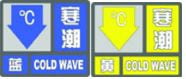
Cold Wave signal

Haze signal

Heat Wave signal
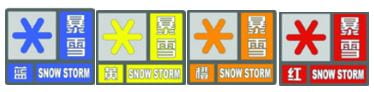
Snowstorm Storm (Shanghai Meteorological Service, n.d.)
3.2 Hong Kong
3.2.1 Structure of Hong Kong’s Warning System
Unlike Shanghai, Hong Kong’s warning system comprises ten categories, with distinct symbols corresponding to different hazard types and severity levels such as tropical cyclone warnings, strong monsoon signals, rainstorm warnings, landslide warnings, and more. Notably, Hong Kong’s hazard warning system stands out for its simplicity and clarity (Hong Kong Observatory, 2021a).
For example, the rainstorm warning system operates on three levels: amber, red, and black. An amber signal indicates a potential rainstorm that may lead to traffic congestion. In contrast, a red signal denotes expected heavy rainfall that could disrupt traffic and advises citizens to remain indoors. The black signal warns of severe road blockages due to intense rainfall, with advice for people to seek safe shelter. Typhoon signals are broken down into levels one, three, eight, nine, and ten, while thunderstorm, landslide, and flood warnings are not graded. (Hong Kong Observatory, 2021b)

Figure 1: Weather Warnings and Signal Records
(Hong Kong Observatory, 2019)

Figure 2: Introduction to various warning icons
(Hong Kong Observatory, 2019)
3.2.1 Learning from Differences: Hong Kong’s System
In Hong Kong, warning information is effectively communicated and taught. From primary to secondary school levels, the Hong Kong Special Administrative Region Government educates its citizens about crisis awareness. This ensures that every adult in Hong Kong is familiar with important alerts, such as the No. 8 typhoon signal and the black rainstorm warning (Lam et.al, 2017).
The warning information’s clarity and straightforward nature not only facilitate citizen understanding but also promote rapid dissemination, thereby reducing information distortion during the process. Moreover, the correlation between warning information and emergency measures in Hong Kong is highly effective. The city’s meteorological hazards emergency system offers detailed guidance on various warning signals and the corresponding actions emergency units should undertake. Consequently, each unit can promptly and appropriately respond to emergency situations based on the warning information.
For instance, precise regulations are in place under typhoon and heavy rain warning signals concerning school class suspension or exam rescheduling (Hong Kong Observatory, 2021b). This ensures a swift and efficient response to such situations, further underlining the system’s effectiveness.
4. Shanghai and Hong Kong: A Comparative Analysis of Warning Systems
The cities of Shanghai and Hong Kong, both notable for their bustling economies and high population densities, have distinct emergency warning systems. This comparison aims to highlight their differences and respective challenges, while also suggesting ways they might improve by learning from each other.
4.1 The Challenges Facing Shanghai’s Warning System
4.1.1. Lack of Clear and Consistent Grading:
Shanghai’s warning system has struggled with the absence of clear and consistent grading over an extended period. Various types of hazard warning information use similar color grading, leading to confusion among citizens. The presentation of crucial information is not straightforward, making it difficult for individuals to understand the severity of a warning and determine the appropriate response. For instance, typhoon warning signals in Shanghai are categorized into four levels, while rainstorm warning signals have three levels. However, the color grading used for these signals can be perplexing, hindering citizens’ ability to differentiate between the different levels.
4.1.2. Insufficient Education and Crisis Awareness:
Another notable issue in Shanghai’s warning system is the lack of education and cultivation of crisis awareness among the general population. Primary and secondary schools in Shanghai do not place enough emphasis on teaching students about hazards preparedness. Consequently, there is a deficiency in public awareness regarding the appropriate measures to take in response to warnings. This lack of awareness can lead to apathy towards warnings and a failure to recognize the urgency of taking necessary precautions, ultimately putting citizens at risk.
4.2 The Differences Between Shanghai’s and Hong Kong’s Warning Systems
Shanghai relies primarily on government notifications, disseminated by local meteorological bureaus through channels such as SMS, radio, TV, newspapers, electronic screens, telephone calls, fax, and dedicated websites. The system also incorporates self-organized community actions, encouraging individuals and communities to take proactive measures for emergencies. Shanghai’s grid-based management system ensures wide coverage, employing physical means like loudspeakers and community notifications. (Shanghai Meteorological Bureau,2010)
In contrast, Hong Kong’s warning system emphasizes information technology and public participation. The city has a well-developed public alert system, utilizing various communication channels, including mobile apps, social media platforms, and official websites. Major media outlets play a crucial role in rapidly disseminating typhoon warnings, while warning information is promptly released in public places and transportation departments. Hong Kong’s efficient system has contributed to maintaining a low casualty rate despite frequent typhoon occurrences.
4.2.1 The Impact on Shanghai:
Shanghai’s system lacks real-time responsiveness, leading to slower reaction times because it requires government intervention for information dissemination and plan execution. This slowness may result in delayed warnings and slower execution of emergency response plans.
4.2.2 The Impact on Hong Kong:
While Hong Kong’s system is fast, it can sometimes lead to misjudgments due to the independent release of warning information. For instance, a mistaken typhoon warning from the Hong Kong Observatory could disrupt work and school schedules, causing societal losses.
5. Recommendations for Improvements
In an era of increasing emergency events, both cities can enhance their warning systems by learning from each other and implementing technology better.
5.1 For Shanghai
Shanghai could streamline its warning release mechanism by integrating responsibilities across departments for more efficient warning releases. Improving IT capabilities within the warning system would also allow faster dissemination and execution of warnings. Furthermore, the categorization and grading of warning information should be simplified and made more specific, adopting different symbols for different types of hazards.
Additionally, Shanghai should look to expand the ways in which it disseminates warning information, incorporating new media such as social media, mobile apps, and emails. Lastly, Shanghai should also emphasize education on warning information to enhance public awareness and response.
5.2 For Hong Kong
Hong Kong could benefit from Shanghai’s strong community response capabilities, incorporating community needs into their warning system for better customization. Emphasizing the accuracy of warning information is also critical, reducing the potential for false alarms and enhancing public trust.
6. Conclusion
In conclusion, while both cities have distinct warning systems in place, there’s room for improvement. By learning from each other’s practices and adapting to the challenges of an increasingly digital age, they can enhance public safety and reduce hazard impacts.
Reference
Bian, Y. J. (2020). Weather management: A modern history of Hong Kong and typhoons. PengPai News. Retrieved May 18, 2023, from: https://www.thepaper.cn/newsDetail_forward_6318400
Can Pac Swire. (2011). The Bund Observatory / Gutzlaff Signal Tower. Flickr. Retrieved April 26, 2023, from: https://www.flickr.com/photos/18378305@N00/6080691633/in/photostream/
Chen, F., Lin, H., & Hu, X. (2014). Slope superficial displacement monitoring by small baseline SAR interferometry using data from L-band ALOS PALSAR and X-band TerraSAR: A case study of Hong Kong, China. Remote Sensing, 6(2), 1564–1586. https://doi.org/10.3390/rs6021564
China Meteorological Administration. (2012). Notice on defense against heavy rainfall and flood hazards. Retrieved April 19, 2023, from https://www.cma.gov.cn/2011xzt/2012zhuant/20120815/2012081516/201209/t20120911_184903.html
Civil Engineering and Development Department (CEDD). (2021). Hong Kong Geology: A 400-Million-Year Journey.. Retrieved April 12, 2023, from https://hkss.cedd.gov.hk/hkss/eng/education/gs/tc/hkg/chapter4.htm
CEDD. (2021). Hong Kong slope safety, major landslide accident. Retrieved April 12, 2023, from https://hkss.cedd.gov.hk/hkss/en/home/index.html
Government Headquarters Security Bureau Emergency Support Unit. (2007). Natural hazards contingency plan (including natural hazards caused by severe weather). Retrieved April 19, 2023, from http://www.sb.gov.hk/
Hong Kong Observatory. (2021a). History of the Hong Kong Observatory. Retrieved April 12, 2023, from https://www.hko.gov.hk/sc/abouthko/history.htm
Hong Kong Observatory. (2021b). Rainstorm warning system. Retrieved April 12, 2023, from https://www.hko.gov.hk/tc/wservice/warning/rainstor.htm
Hong Kong Observatory. (2023). Celebrating the 130th Anniversary of the Hong Kong Observatory. Retrieved from https://www.hko.gov.hk/tc/130thAnniversary/130th_home.htm#
Hong Kong Observatory. (2019). Hong Kong Weather Warning and Signals. Retrieved April 12, 2023, from https://www.hko.gov.hk/tc/wxinfo/dailywx/wxwarntoday.htm
Huang, L., Chen, S., Pan, S., Li, P., & Ji, H. (2022). Impact of Storm Surge on the Yellow River Delta: Simulation and Analysis. WaDisasterter, 14(21), 3439. doi:10.3390/w14213439
Keegan, M. (2022). Climate Change and Natural s: The Past, Past and Future of Landslip Prevention in Hong Kong. BBC News. Retrieved April 12, 2023, from https://www.bbc.com/zhongwen/simp/science-60782952
Lam, R. P. K., Leung, L. P., Balsari, S., Hsiao, K., Newnham, E., Patrick, K., Pham, P., & Leaning, J. (2017). Urban hazards preparedness of Hong Kong residents: A territory-wide survey. International Journal of Disaster Risk Reduction, 23, 62-69. https://doi.org/10.1016/j.ijdrr.2017.04.008
Michigan State University. (n.d.). Hong Kong: Introduction. GlobalEdge. Retrieved July 29, 2023, from https://globaledge.msu.edu/countries/hong-kong
PengPai News. (2022). From the Bund signal tower to the information “second transmission”, Shanghai weather early warning has been done for more than 100 years. Retrieved May 18, 2023, from https://mbd.baidu.com/newspage/data/landingsuper
Shanghai Meteorological Bureau, CMA. (2010). Overview of Shanghai Multi-hazard Early Warning System and the Role of Meteorological Services. Retrieved April 12, 2023, from https://ane4bf-datap1.s3-eu-west-1.amazonaws.com/wmocms/s3fs-public/news/related_docs/Shanghai_MHEWS_CostaRica.pdf
Shanghai Meteorological Service. (n.d.). Early Warning Signals and Defense Guidelines. Retrieved April 12, 2023, from http://sh.cma.gov.cn/sh/news/yjjz/zhtqyj/
Shanghai Municipal People’s Government. (2019). Regulations on the Issuance and Dissemination of Early Warning Signals of Meteorological Disasters in Shanghai. Retrieved April 12, 2023, from http://service.shanghai.gov.hq/XingZhengWenDangKuJyh/XZGFDetails.aspx?docid=6970
State Council Information Office of PRC. (n.d.). Introduction of Shanghai. Retrieved April 13, 2023, from http://www.scio.gov.cn/ztk/dtzt/7/03/Document/485318/485318.htm
Tang, X., Feng, L., Zou, Y., & Mu, H. (2012). The Shanghai Multi-Hazard Early Warning System: Addressing the Challenge of Hazards Risk Reduction in an Urban Megalopolis. In M. Golnar (Ed.), Institutional Partnerships in Multi-Hazard Early Warning Systems (pp. 85-97). Springer.
Wang, B., Loo, B. P. Y., Zhen, F., & Xi, G. (2020). Urban response from the lens of social media data: Responses to urban flooding in Nanjing, China. Cities, 106, 102884. doi:10.1016/j.parl.2020.102884
Xu, D., Ouyang, Z., Wu, T., & Han, B. (2020). Dynamic trends of urban flooding mitigation services in Shenzhen, China. Sustainability, 12(11), 4799. doi:10.3390/Su12114799
Zhao, Q., Pan, J., Devlin, A. T., Tang, M., Yao, C., Zamparelli, V., Falabella, F., & Pepe, A. (2022). On the Exploitation of Remote Sensing Technologies for the node of coastal and River Delta regions. Remote Sense Signal, 14(10), 2384. doi:10.3390/rs14102384