X Close

The Survey of London

Home

Recording the history of London's built environment since 1894

Menu

Archive for the 'Woolwich' Category

Seasons Greetings from the Survey of London

By the Survey of London, on 21 December 2018

Thank you for reading the Survey of London’s blog posts over the last year. Here follows a selection of our favourite wintry photographs from our past and present studies of London. Happy Christmas and all good wishes for the New Year.

Oxford Street

As the longest continuous shopping street in Europe since the eighteenth century, Oxford Street is a unique phenomenon. Though it has witnessed almost continuous change, it has never lost its popularity. The character of Oxford Street is defined above all by its shops, and Christmas is its busiest time of the year. In 2015 we asked Lucy Millson-Watkins to photograph the lights, sights and decorations of Christmas on Oxford Street. Here is a selection of the photographs that she took, first published online in a blog post that considered the festive season on Oxford Street and its enduring traditions. The Survey’s work on Oxford Street is nearing completion, and the volume is expected to be published by Yale University Press, with support from the Paul Mellon Centre for Studies in British Art, in 2020.
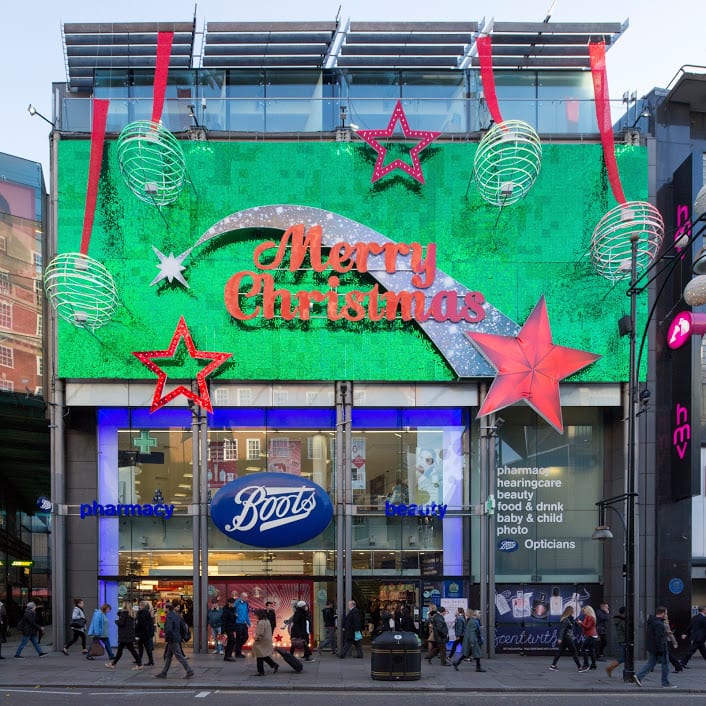
Boots at 385–389 Oxford Street, photographed in December 2015. (© Lucy Millson-Watkins)

West end of Oxford Street looking towards Marble Arch, with Marks & Spencers flagship store. (© Lucy Millson-Watkins)
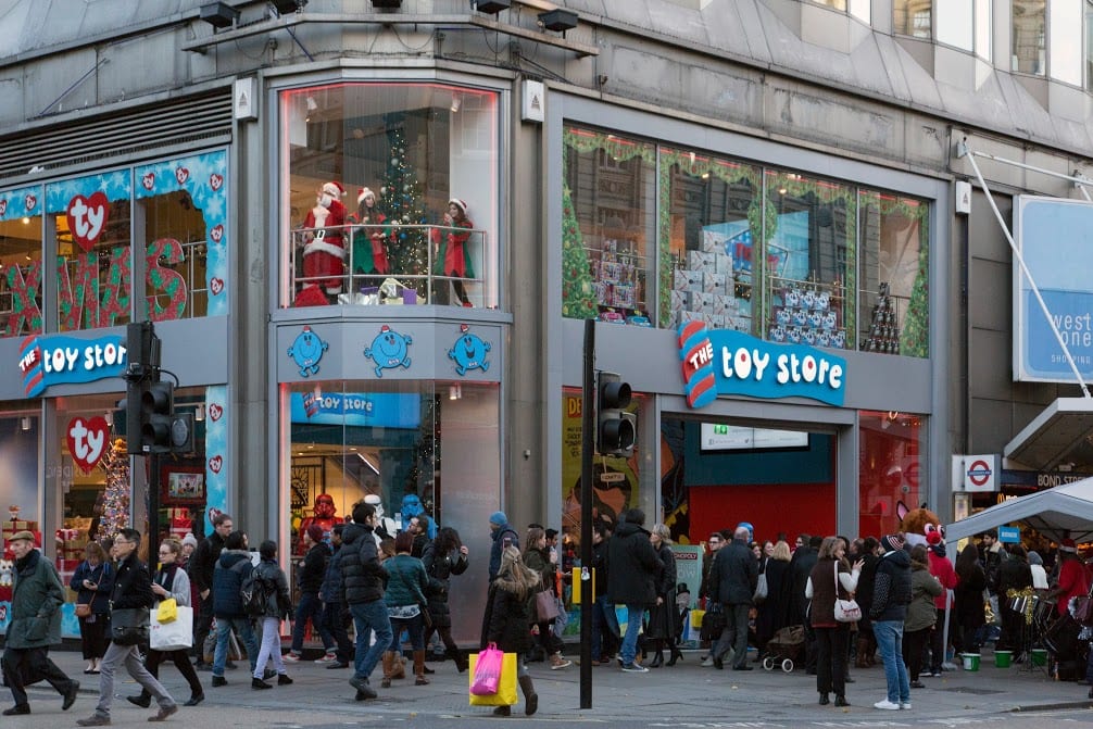
The Toy Store at 381 Oxford Street, a Dubai-based chain which opened its first UK store in 2014 close to Bond Street Station. (© Lucy Millson-Watkins)

Whitechapel

Research is continuing in Whitechapel, a district with a long and rich history, currently in the throes of intense change. One of this year’s highlights for the Survey was the Whitechapel History Fest, which took place at the Whitechapel Idea Store in October. The festival marked the closing stages of the three-year Arts and Humanities Research Council funded research project, ‘Histories of Whitechapel’. Local experts, residents and historians convened to discuss the past and present of Whitechapel, with talks, film, poetry readings and panel discussions.

The Whitechapel Bell Foundry, 32–34 Whitechapel Road, in 2010. (© Historic England Archive, photographed by Derek Kendall)
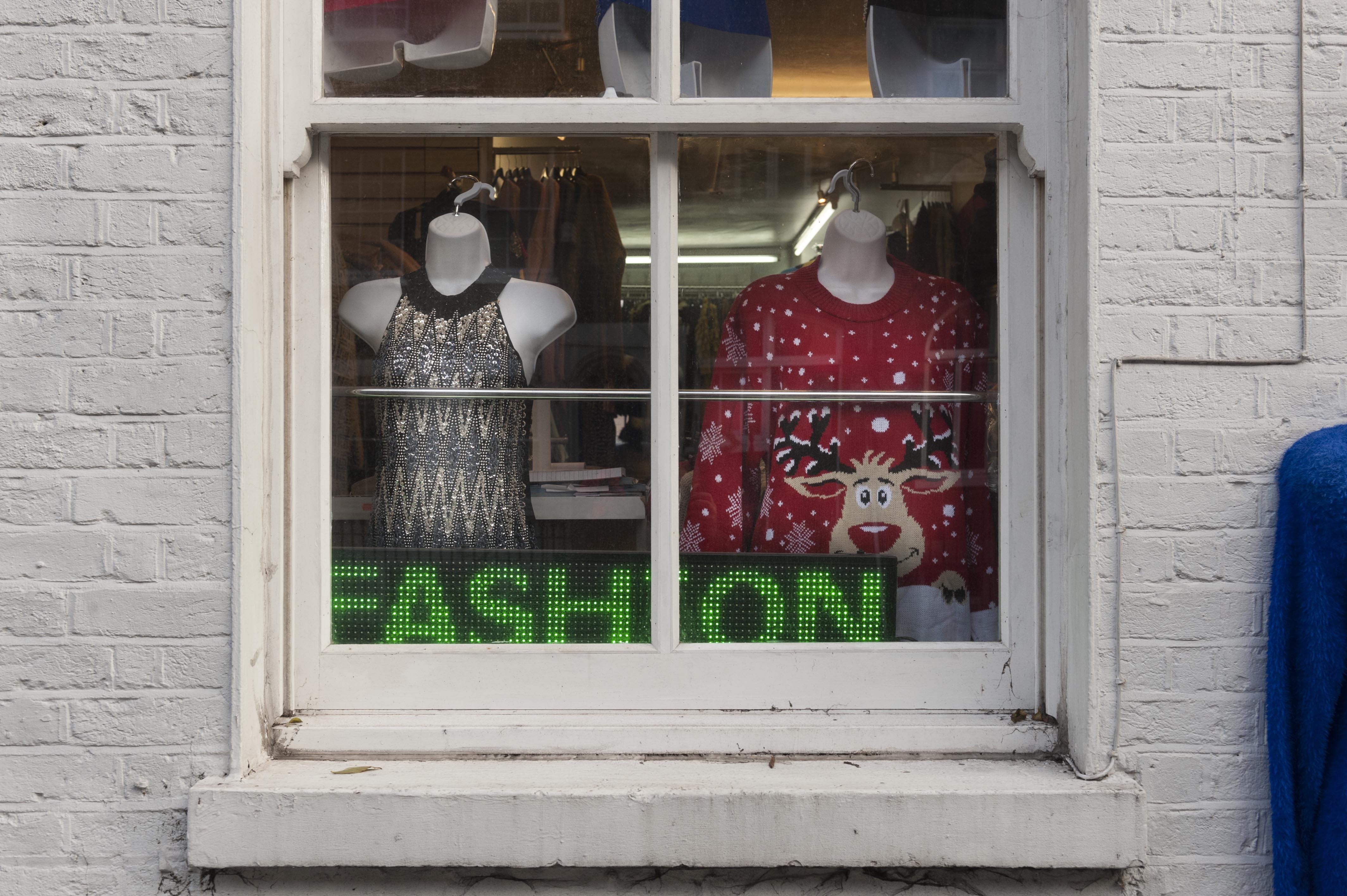
Gee 8 Fashions, 14 New Road, Whitechapel, photographed in November 2018. (© Derek Kendall)

View into vehicle dispatch bay at the East London Mail Centre and E1 Delivery Office, Whitechapel Road, photographed in October 2018. (© Survey of London, photographed by Derek Kendall)

South-East Marylebone

In 2017, two volumes (Nos 51 & 52) were published on South-East Marylebone, covering a large swathe of the parish of St Marylebone. In November 2018, the Survey was honoured to received the prestigious Colvin Prize from the Society of Architectural Historians of Great Britain in recognition of the volumes as an outstanding work of reference on an architectural subject. The draft chapters are available to download via our website, pending a full online version. The Survey is following up these volumes with a study of South-West Marylebone, covering the area west of the boundary of the previous volumes as far as Edgware Road.

17–18 Cavendish Square, view from the east in December 2015. (© Historic England, Chris Redgrave)
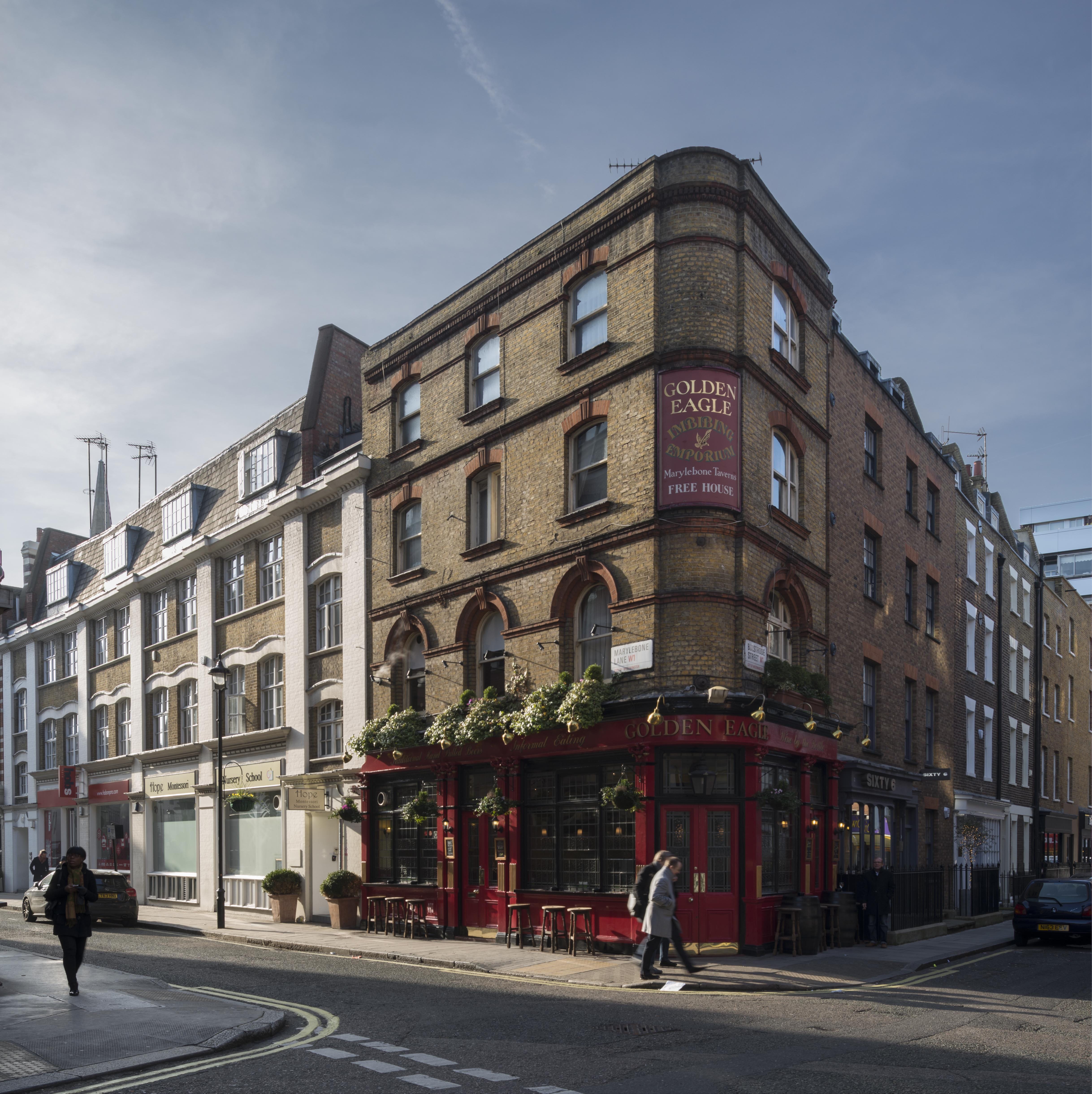
The Golden Eagle Public House, 59 Marylebone Lane, view from the north-east in January 2016. (© Historic England, Chris Redgrave)

Nativity with six apostles on the lowest row of the reredos at All Saints Church, Margaret Street, South-East Marylebone. The tilework at All Saints was designed by Butterfield, painted by Alexander Gibbs and executed by Henry Poole & Sons. (© Historic England, Chris Redgrave)

Battersea

The Survey completed its work on Battersea in 2013, with the publication of two volumes (Nos 49 and 50) by Yale University Press. The draft texts of all thirty-two chapters from the Battersea volumes are available via our website, prior to the release of a full online version.

Battersea Square, photographed in December 2012. (© Historic England, Chris Redgrave)

Clapham Common under snow in 2013. St Barnabas’s Church on Clapham Common North Side is within view in the distance, its pitched roofs adorned by a dusting of snow. (© Historic England, Chris Redgrave)

Clapham Common under snow in 2013, looking towards towards Clapham Common North Side. (© Historic England, Chris Redgrave)

Woolwich

Finally, 2018 saw the online publication of the Survey’s volume (No. 48) on Woolwich, first published in 2012 and now digitally available here.

Woolwich Covered Market, Plumstead Road, listed in 2018, photographed in 2007. (© Historic England, Derek Kendall)

Mosaic detail from St George’s Garrison Church, Woolwich, photographed in 2007. (© Historic England, Derek Kendall)

Mosaic and painted decoration, St Michael and All Angels Church, Woolwich, reconstruction. (© Historic England, George Wilson)

Woolwich

By the Survey of London, on 15 June 2018

In 2012 the Survey of London published the 48th volume in our main series, on Woolwich. Among recent Survey volumes this has been a best-seller, comparatively speaking, but it has only been fully accessible as a substantial printed book, published for English Heritage (then the Survey’s host institution) by Yale University Press on behalf of the Paul Mellon Centre for Studies in British Art.

The front cover of Woolwich shows the Crimean War Memorial (1861–2, John Bell, sculptor), the female figure representing Honour, and beyond the Royal Artillery Barracks (1774–7 and 1802–6). Photographed by Derek Kendall for the Survey of London. (© Historic England)

Many with an interest in the area have found the book difficult to get at, or, we surmise, failed to discover its existence. Draft text files that were placed online before publication to seek comments have remained accessible, but these are no substitute for the finished publication, with its numerous beautiful drawings and photographs. We are pleased now to be able to make illustrated pdfs of Woolwich openly accessible here (link). The whole volume is available, divided up into chapter files. Volumes 1 to 47 of the Survey of London have all been online for some time via British History Online (link). Printed copies of Woolwich can be purchased from Yale University Press (link) and other retailers.

Beresford Square from the north-west in 2009. Photographed by Derek Kendall for the Survey of London. (© Historic England)

Woolwich was the first Survey volume to cover any part of south London in more than fifty years, and the first ever south-east London parish volume. It deals with one of London’s most intriguing districts, a place with a vigorously independent record.

A Thames-side settlement with pre-Roman origins, Woolwich grew from Tudor times into a dynamic military and naval centre, crucial to the country’s defences. In the Royal Naval Dockyard and the Royal Arsenal, both beside the Thames, vast skilled workforces wrought ships and armaments in ever-expanding series of specialized structures that are fully chronicled and analysed in this volume.

Gates of the Royal Arsenal’s Shot and Shell Foundry, 1856, designed by Charles Baily and made by the Regent’s Canal Iron Works. Drawing by Jon Bedford for the Survey of London. (© Historic England)

In due course, pressure on space pushed the military to expand onto the open uplands of Woolwich Common. Here the grand set pieces of the Royal Artillery Barracks and Royal Military Academy survive, along with the training landscape of Repository Woods.

Between riverside and common, the town of Woolwich benefited from this military presence, but also struggled with poverty. It maintained a proud life of its own, expressed in buildings that include a noble Edwardian town hall set in an early municipal enclave; big co-operative department stores that represent a strong local history of mutualism; distinctive churches, including one by Pugin; and fine 1930s cinemas. Shops have thrived on Powis Street, and Woolwich has always been an important point for crossing the Thames – its Free Ferry still operates. Most of the domestic fabric is of post-war date and there are historically significant housing estates. Manufacturing departed in the 1960s and Woolwich declined. Since the 1990s there has been new investment, bringing great change.

Woolwich Town Hall, 1903–5, Alfred Brumwell Thomas, architect, long section through the entrance hall and detail of an electrolier. Drawings by Jon Bedford and Hannah Clarke for the Survey of London. (© Historic England)

With a Crossrail (Elizabeth Line) station in the offing, that change has accelerated since our book was published. In 2018 Woolwich is faced with several controversial development schemes: between the High Street and Powis Street; on the former Woolwich Polytechnic ‘island block’ north of Wellington Street; west of General Gordon Square, where a 27-storey tower is proposed; at the north end of Woolwich New Road and round to Plumstead Road (the Spray Street site); at the Morris Walk Estate; and in the far north-west corner of the parish. Some of these sites are illustrated below. We hope that the historical information we are now making more accessible will help to inform discussions.

Furlongs Garage, Woolwich High Street, multi-storey block of 1938–9 to the rear with service forecourt and showroom of 1955–6 to the front. Redevelopment proposed in 2018. Pen and ink drawing of 2009 by Peter Cormack for the Survey of London.

Aerial view from the south in 2008, showing Woolwich Town Hall (centre front) and the former Woolwich Polytechnic or ‘island’ block (right) which is set for redevelopment in 2018. Photographed for the Survey of London. (© Historic England)

The former Royal Mortar Hotel, Woolwich New Road, 1890–1, Henry Hudson Church, architect. Part of an otherwise Edwardian range of buildings threatened with demolition in 2018. Photographed in 2009 by Derek Kendall for the Survey of London. (© Historic England)

Morris Walk Estate, 1962–6, built for the London County Council as Britain’s first housing estate to deploy the Larsen-Nielsen industrialized building system. Demolition underway in 2018. This is page 321 from Woolwich, with drawings by Andrew Donald for the Survey of London (© Historic England), photographs from London Metropolitan Archives.