 Close
Close

125 years of the Survey of London
By the Survey of London, on 6 September 2019
This year marks the 125th anniversary of the Survey of London, a venerable institution that produces architectural and topographical studies of districts of London. To mark that milestone this blog post traces the Survey’s remarkable history, from its origins as a recording project undertaken by a band of volunteers to its present-day work carried out from its current base at the Bartlett School of Architecture, University College London.

C. R. Ashbee, photographed by Frank Lloyd Wright in 1900
The Survey traces its roots to the Arts and Crafts architect, designer and social thinker Charles Robert Ashbee, who established a Committee for the Survey of the Memorials of Greater London in 1894. Ashbee’s efforts to produce a ‘register’ or a list of buildings were prompted by the demolition of a Tudor hunting lodge in Bromley-by-Bow to make way for a Board School, which coincided with a growing sense of unease around the destruction of historic fabric in London. Members of the Committee decided to focus their work initially on the east side of London. Drawings, photographs and notes were produced to record buildings of interest and inform conservation. The first publication was a monograph on Trinity Almshouses in Mile End Road, which was threatened with demolition at the time. The resulting volume (published in 1896) interwove architectural history with social and cultural threads, contributing in no small part to a successful campaign for preservation of the almshouses.

Bird’s-eye view of Trinity Almshouses from Mile End Road, looking north. Illustration by Matt Garbutt

Two elderly sea-captains playing draughts. Illustration by Max Balfour
The Committee soon started to collaborate with the London County Council (LCC), which agreed to cover the cost of printing volumes relating to the more confined area under its jurisdiction. From this point onwards, the geographical remit of the Survey has been restricted to the area within the County of London as between 1889 and 1965. The LCC subsequently published the first volume in the main or ‘parish’ series, which focused on Bromley-by-Bow (1900). The project was infused with Ashbee’s social ideals, particularly his conviction that to mark down a record of historic buildings was an essential public good that would enhance the lives of Londoners: ‘We plead that the object of the work we have before us, is to make nobler and more humanly enjoyable the life of the great city whose existing record we seek to mark down; to preserve of it for her children and those yet to come whatever is best in her past or fairest in her present; to induce her municipalities to take the lead and to stimulate among her citizens that historic and social conscience which to all great communities is their most sacred possession.’

Progress report of the Committee printed in 1897, including a list of honorary members, who received a copy of the volumes in return for a subscription
Despite the early links with the capital’s governing body, the Survey was not formally associated with the LCC for some time. In 1907, after Ashbee’s relocation to Chipping Campden, management of the Committee passed to Philip Norman, Percy Lovell and Walter H. Godfrey. After protracted discussions, an agreement between the Committee and the LCC was finally reached in 1910. The Committee agreed to deposit its extensive collection of material with the LCC, in exchange for the Council bearing the cost of printing the volumes. This arrangement continued for more than forty years. Under the auspices of the LCC, the Survey shifted gradually from being a project led by amateurs and enthusiasts – ‘whose’, to borrow Ashbee’s words, ‘best work is done on Saturday afternoons and summer holidays’ – to one undertaken by professional historians. The LCC embarked on a study of the parish of St Giles-in-the-Fields and Lincoln’s Inn Fields, which coincided with its plans to form Kingsway and Aldwych and in the event contributed to the preservation of buildings. The production of the series was balanced between the LCC and the Committee, which published volumes alternately under a Joint Publishing Committee.

Pamphlet circulated to mark the publication of Eastbury Manor House (1917) the eleventh volume in the monograph series
The early volumes were consequently uneven in style and selective in scope, often focusing on the oldest or most high-status buildings in a parish. Each volume followed a similar format, comprising a map of the study area, an introduction, a register of buildings and a sequence of illustrations, including photographs and measured drawings. A separate series of monographs, focusing on single buildings and individual sites of particular interest, was published in parallel with the main ‘parish’ series.

Ida Darlington and Marie Draper, c.1950
After the completion of four volumes on St Pancras in 1952, the Survey Committee was disbanded. It was a decision reluctantly taken, brought about by a lack of ‘recruits for the heavy unpaid work which an earlier generation undertook with enthusiasm.’ [1] The editing work was at first taken on by Ida Darlington, who had started working on the Survey as a research assistant in 1926, but it proved impossible to balance with the considerable demands of her existing role as head of the record office and library at the LCC.

Francis Sheppard, the first General Editor of the Survey of London
From 1954 the Survey was managed entirely by the LCC, which appointed a General Editor to lead a small team of full-time staff. The first General Editor was Francis Sheppard, who oversaw the production of the series until his retirement in 1983. During those twenty-nine years, Sheppard published sixteen volumes in the Survey’s main series and developed a unique and enduring formula for its work: a complete record of the built fabric of each study area, integrated with social and economic detail.

Bird’s-eye view of Covent Garden Market area. Drawn by F. A. Evans and T. P. O’Connor (Survey of London, Volume 36, Covent Garden, 1970)

Note to Francis Sheppard from John Betjeman, 1959
After the abolition of the LCC in 1965, the Survey transferred to the Greater London Council (GLC). In an interview with The Daily Telegraph in 1976, Sheppard described the approach to choosing study areas: ‘Basically we have to decide where surviving buildings are thickest on the ground and where they are most likely to be demolished most quickly, but of course we don’t only describe existing buildings. We also list those which have been destroyed.’ Sheppard concentrated the Survey’s investigations on the West End, where many Georgian streets were threatened with demolition. Research in Covent Garden resulted in the listing of many buildings and helped to alter proposals for drastic redevelopment.
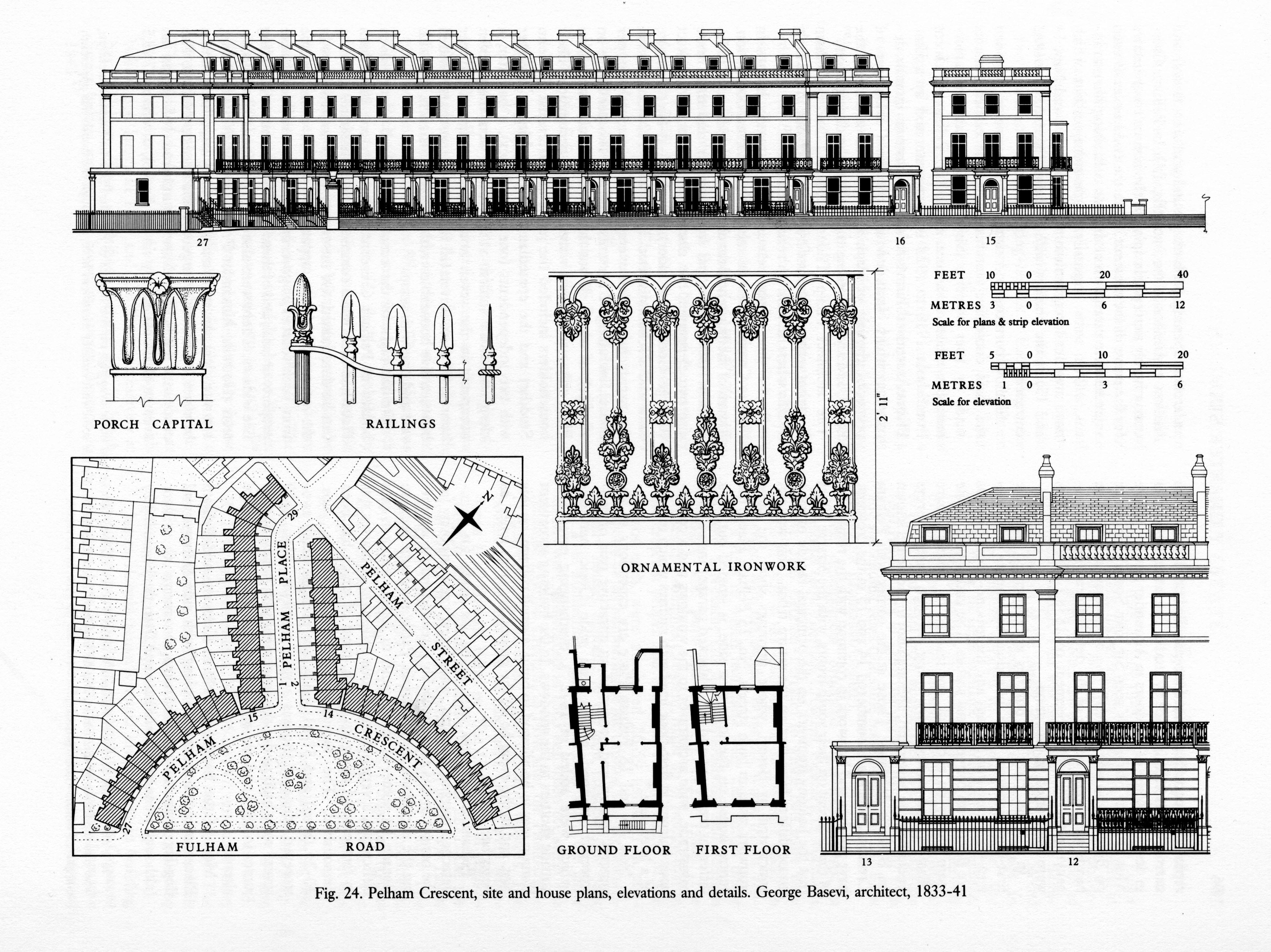
Pelham Crescent, site and house plans, elevations and details. Drawn by John Sambrook (Survey of London, Volume 41, Brompton, 1983)
Following the dissolution of the GLC in 1986, the Survey became part of the Royal Commission on the Historical Monuments of England, where work continued on volumes on County Hall (Monograph 17, 1991) and Poplar, Blackwall and the Isle of Dogs (Volumes 43 and 44, 1994). Studies were subsequently made of Knightsbridge (Volume 45, 2000), Clerkenwell (Volumes 46 and 47, 2008) and the Charterhouse (Monograph 18, 2010). In 1999 the Royal Commission merged with English Heritage. The team next moved its investigations south of the river to Woolwich (Volume 48, 2012) and Battersea (Volumes 49 and 50, 2013). The Survey remained under the purview of English Heritage until 2013, when it joined the Bartlett School of Architecture at University College London.

The Survey of London team in 2013, photographed in the year of the publication of the fiftieth volume in the series
The Survey continues to produce detailed topographical studies from its new home at the Bartlett, earning recognition for its scholarly rigour and pioneering approaches. In 2018, the Survey was honoured to receive the prestigious Colvin Prize from the Society of Architectural Historians of Great Britain for two volumes (Nos 51 and 52) covering south-east Marylebone (2017).

The Langham Hotel, Langham Place, drawn from measured survey by Helen Jones and Andy Crispe (Survey of London, Volume 52, South-East Marylebone, 2017)

All Saints’ Church, Margaret Street, view towards the east end (© Historic England, Chris Redgrave, published in Survey of London, Volume 52, South-East Marylebone, 2017)

John Lewis, detail of Oxford Street front at the corner with Old Cavendish Street in 2018 (© Historic England, Chris Redgrave)
The Survey is continuing its work in Westminster with a volume covering Oxford Street (Vol. 53), which is set to be published in Spring 2020, and a volume on south-west Marylebone (Vol. 56). The current study of Whitechapel (Vols 54 and 55) has been supported by a major grant from the Arts and Humanities Research Council, which has funded the development of a public collaborative website to experiment with integrating memories, moving images and texts, illustrations and experiences by numerous others with the work of the Survey. Research has also commenced towards a monograph on UCL’s campus in Bloomsbury.

St George’s Lutheran Church and School, Alie Street, Whitechapel. Drawn by Helen Jones of the Survey of London

Map of the London Hospital and its surroundings in Whitechapel, showing the footprint of the main hospital building, specialised departments, and nurses’ homes. Redrawn by Helen Jones from Ordnance Survey maps of 1913 and 1948
The Survey’s detailed investigations do take time, and even after 125 years a good deal of the map remains untouched. As the architectural historian Sir John Summerson said, ‘The Survey will never be finished. If the time comes when a final “coverage” seems to be in sight it will be time to begin again. London changes. So does the writing of history. The Survey as the continuing illustrator and expositor of the fabric of London has a function with no imaginable term.’
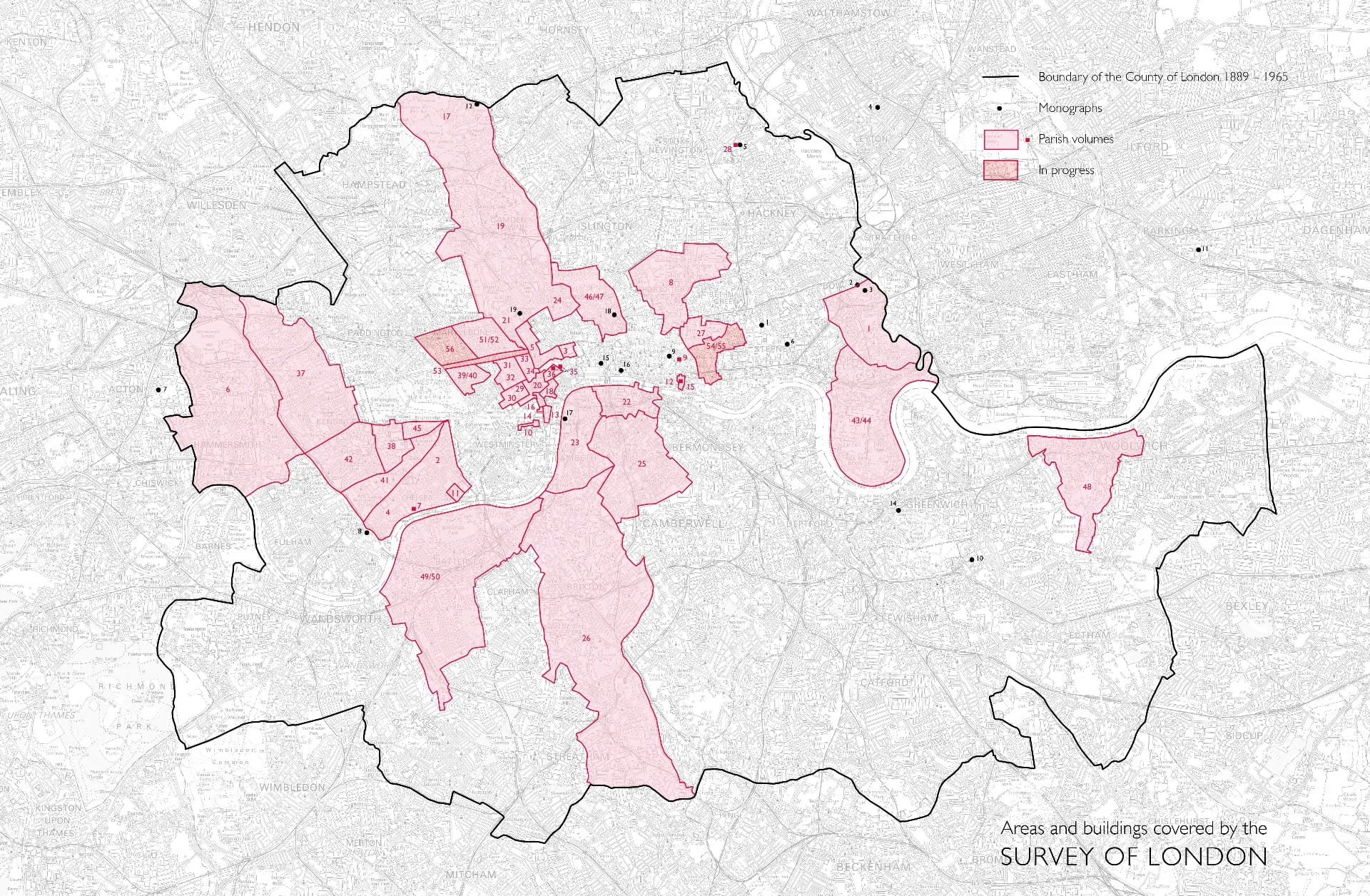
Areas and buildings covered by the Survey of London. Please click to expand
[1] Walter H. Godfrey, lecture at the University of London, 5 January 1954
