A Short Tale of Fieldwork
By Claudia Sgambato, on 26 July 2018
Fieldwork represents a fundamental part of my PhD research, and, as a geologist, it is also my favourite part of the job. In June 2018, I flew to Italy for the first of many fieldtrips, with Joanna Faure Walker, my primary supervisor. Together we worked for five days to conduct detailed mapping of and data collection from the Auletta fault, located in Campania, Southern Italy.
The Italian Apennines are undergoing a southwest-northeast extension, associated with earthquakes of moderate and large magnitudes, occurring on active normal faults. The exact location of these faults and rates of movement across them represents an important factor for the seismic hazard.
The fault studied is located in the Vallo di Diano, one of the extensional intramontane basins that characterise this sector of the Southern Apennines; the basin, filled by river and lake fan and slope deposits, is bordered on the East side by a major fault system, terminating to the North with the 3 km long fault strand that was the object of this study.

The Auletta fault scarp seen about half way up the slope as a grey line that offsets the topography, where my fieldwork was focussed. This fault scarp crosses the Cretaceous carbonates of Mt. San Giacomo for about 3km (photograph credit: Claudia Sgambato).
Many large magnitude earthquakes have struck the Southern Apennines in the past 1000 years, with an average of one event every 50 years. For instance, in 1694, a M=6.9 event with epicentre in Irpinia caused about 6000 casualties; in the same area, in 1980, a M=6.9 earthquake caused about 3000 deaths. Some events had damage consistent with them possibly occurring on the Auletta fault, like the two events in 1561 (M=6.7) that caused 600 casualties. Moreover, there is a debate on the location and nature of the structure responsible for one of the strongest earthquakes in the area, which occurred in 1857 in the Northern Vallo di Diano and Val d’Agri, causing between 10,000 – 20,000 casualties.
The main aim of my fieldwork on this trip was to collect detailed data along the fault scarp of the fault geometry (strike and dip), together with offset and slip direction data, to understand how these vary along what we consider the termination, or tip, of the fault. In fact, my research project investigates how the geometry of both individual faults and fault arrays in the Central and Southern Apennines influences the seismic hazard. All these data collected in the field, such as the fault orientation, length, strike and dip, slip to length ratios, will be used to study what controls the variability in slip-rates along the faults and how the fault geometry and faults interaction can affect earthquake recurrence intervals.

Joanna is taking measurements of the strike and dip of the fault (photograph credit: Claudia Sgambato).
Our typical day in the field started with an early breakfast, to avoid the heat and to reach the fault scarp at an elevation of 750m, as soon as possible. Then we walked along the scarp, taking measurements of strike and dip and slip vector, and where possible, measuring the throw using a meter ruler, which requires lying on the ground and sliding through the slope for about 100m.
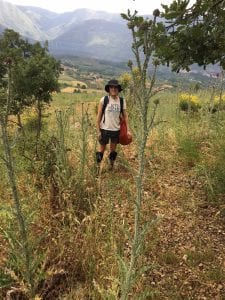
You would think that the best part of fieldwork is the immersion in nature, with the fresh breeze and the warm sun of an early summer in Italy. Indeed, growing up in southern Italy means I have many such memories. But, there is the other side of the coin: imagine starting a day by facing some steep, slippery, muddy, slopes, covered in thistles, the kind that grows taller than you! Then later in the day, while working in the sun, suddenly heavy clouds cover the sky and rain, loud long-lasting thunders, and all the things you don’t expect from an Italian summer, happen, every day over those five days. And while you are trying to save your precious maps and notebook from the pouring rain, your legs and arms experience all kinds of thorns and stings. Well, this is fieldwork! The joy of working in the best “office” in the world, and all the (mis)adventures that come with it.

Negotiating through the thistles on my way up to the fault scarp – the Vallo Di Diano in the background – my “office” view (Photograph credit: Joanna Faure Walker).
Even if this field trip wasn’t exactly as expected, I learned a lot thanks to Joanna. We had a fun time, enjoying the stunning views, and more importantly, we brought back some interesting data that will keep me busy while I am already organising my next trip.
 Close
Close


