 Close
Close

In-conversation – Drones for health emergencies: friend or foe? @ the UCL IRDR 9th Annual Conference
By ucfausa, on 3 July 2019
On the 19thof June, Professor Patty Kostkova (UCL IRDR and Director of the UCL IRDR Centre for Digital Public Health in Emergencies) chaired an intriguing panel discussion with invited speaker Jorieke Vyncke (Coordinator of the Missing Maps Activities, Médecins San Frontières (MSF)) on the use Unmanned Aerial Vehicles (UAVs) (or drones) in low income and low resource settings for health emergencies especially in the context of sub-Saharan Africa.

Image 1: Seated is our panel guest Jorieke Vyncke (left). The session was chaired by Professor Patty Kostkova (right)
Jorieke Vyncke coordinates the Missing maps project and was involved in using drone technology in several MSF missions. In collaboration with organisations as the American and British Red Cross and the Humanitarian OpenStreetMap Team, the Missing Maps project wants to map the entire world so as to provide baseline data of all locations including villages and important buildings in remote areas. The session was kick-off with Jorieke Vyncke giving the audience an interactive walkthrough with the various model types of UAVs (or drones) used in operations in sub-Saharan Africa and Asia with MSF.

Image 2: Jorieke does a walkthrough of the various drone models used in her day-to-day operations
She spoke of the day-to-day application of drone technologies to address some of the world’s humanitarian crisis and gives an example – she says:
‘… drones were used by the International Organisation of Migration (IOM) to take direct satellite images for the geospatial triangulation of Rohingya refugee settlements in and around Balukhali in Bangladesh during and after the exodus of Rohingya out of Myanmar in 2017”

Image 3: Around Balukhali (Bangladesh) – 2 December 2017 (Drone images IOM)
She shown remarkable drone images of how the settlements have expanded over time and narrates how the MSF team collaborated with the international Organisation for Migration (IOM), who were given a permission to fly drones over refugee camp, to understand the growing settlement patterns of the Rohingyas to address the issue of displacement.
Professor Kostkova asked whether they have ever used such technology to deliver goods to affected areas to which Jorieke explains:
“Yes, our teams have used drones in Papua New Guinea to transport TB sputum samples to a hospital from health centres in remote villages.”
Difficult questions regarding drone regulation were asked – unlike the Global North where laws are stricter against drone usage in public spaces. In the Global South – unfortunately, this is not the case. Jorieke agreed that in countries like Malawi there were no strict regulation concerning drones in 2017 when the MSF team, lead by Raphael Brechard, used them for mapping the flooded area. She mentioned that at the time:
“…you can become a user without a license”.
She adds the following:
“…while there’s less regulations, MSF tries to maximise good-use of drones [not to compromise people’s privacy]. We try to collaborate with government and local institutions and community leaders before we deploy our drone activities. We also make sure to have strong local knowledge and close ties with the community involved to get their participation and acceptance”.
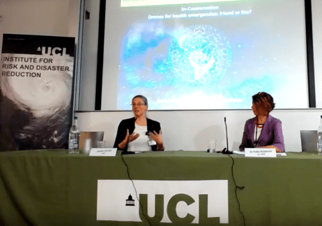
Image 4: Jorieke (left) explaining the advantages and disadvantages of using drones in lower income & low resource settings in the Global South
An interactive panel discussion was held and the floor was opened for the audience to ask interesting questions. Of course, for more interesting details you can watch all live streamed videos on YouTube – remember to hit the like button and subscribe to the channel at UCL IRDR.
Follow us on Twitter @UCL_dPHE & @UCLIRDR
You can follow the Missing maps project and Médecins San Frontières (MSF) on Twitter @TheMissingMaps & @MSF, respectively.
![]()

Concerning all photographs used in this blog. All credit goes to the rightful owner and photographer: Professor Ilan Kelman (IRDR, UCL)