Foulness
By Jon Agar, on 2 August 2017
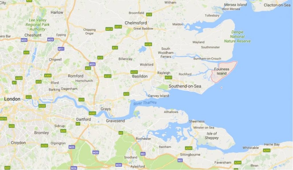
One of the most secret and inaccessible sites in England is the island of Foulness in Essex. An outstation of atomic research, as well as a cluster of other scientific projects that needed space and seclusion, Foulness is also good agricultural land, with a village featuring a steepled church and a pub (both now closed). Once a month during the summer the single access road is opened to allow visitors – tourists, the curious, relatives of islanders, and the odd historian – to explore some of island. I’ve wanted to go for years, and I finally made the trip in May 2017 with friends and family. It was a jolly day out, with a look around the village and volunteer-run Heritage Centre, and a gentle tractor tour around the less sensitive parts of the island. We saw some of the social history of the community, but there was plenty that we did nor or could not see. So I have been digging into the archives and the literature to explore the history of Foulness.
I’ll start with the history of the Foulness community, largely inspired by the story told in the museum. Scroll down for the secret history of science and technology.
(1) Foulness island and community
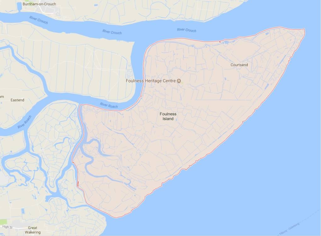
Figure 2. A more detailed view of Foulness. The two centres of civilian population are Churchend (where the Foulness Heritage Centre is marked) and Courtsend. The two large creeks at the south-eastern end of Foulness delimit Havengore and New England “islands”. The Broomway runs parallel to the Eastern edge. The upside-down tear-drop to the west is Potton Island.
Before 1922, foot access to Foulness was via one of the oddest and most dangerous paths in Britain: the Broomway, a track exposed on sand at low tide of the North Sea. There’s a description of walking the Broomway in Robert Macfarlane’s The Old Ways (2012). Otherwise boats ferried people, animals and indeed fresh water back and forth. The community was oriented around the manor house. Artillery practice and research began a few miles south of Foulness at Shoeburyness in the mid-19th century. During the First World War the War Office secured land rights, but only after the recalcitrant lord of the manor died in 1915. In 1922, a military road was built, connecting the mainland near Great Wakering, crossing the dykes and ditches in a more or less straight line into Foulness, across Havengore and New England creeks and finishing at Churchend. A military rail line was built on the island, but it did not connect to the mainland.
Foulness was good for growing crops, making salt (indeed the island grew as saltings were filled), and catching wild fowl – the last activity is the origin of the name. The human population was never much more than 500, and now hovers around 150.
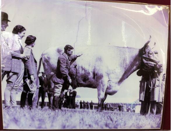
Foulness is rarely in the news, except for rare occasions of the monstrous and the threatening. In the 1930s, the public milling through the Essex Show (and on tour to the Bath & West Show, the Islington Fatstock Show and the Kent Show) marvelled at the “Foulness Ox”. Purchased at Chelmsford cattle market and fattened on the island, this animal was over 6 feet tall and weighed 1.625 metric tons. The Ox’s slaughter was reported by newspapers. Its former owner, Mr. H. Belton, told the Sunday Express that “There never was such an ox in the world”.
Foulness is low-lying land, with sea walls encircling. In 1953 the great flood overwhelmed the defences. While much of the population was evacuated, two people and many sheep and pigs were drowned. In the museum there are aerial photographs, which show the waters surrounding all but the higher land around the church, and a display of toys (Figure 5) sent from America for the children of Foulness as families rebuilt their lives.
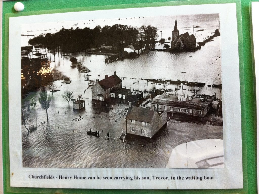
Figure 4. Churchend, Foulness, during the Great Flood of 1953. Photograph on display at Foulness Heritage Centre.

Figure 5. Toys sent from the United States after the Great Flood of 1953. On display at the Foulness Heritage Centre.
In the late 1960s, Foulness was threatened again, this time by the proposal that Maplin Sands, east of the island, could be the location of the third London airport (after Heathrow and Gatwick). A campaign group, the Defenders of Essex, argued that the rural character of the area would be destroyed. The arguments lasted from 1968 to 1974, when the returning administration of Harold Wilson abandoned the idea.
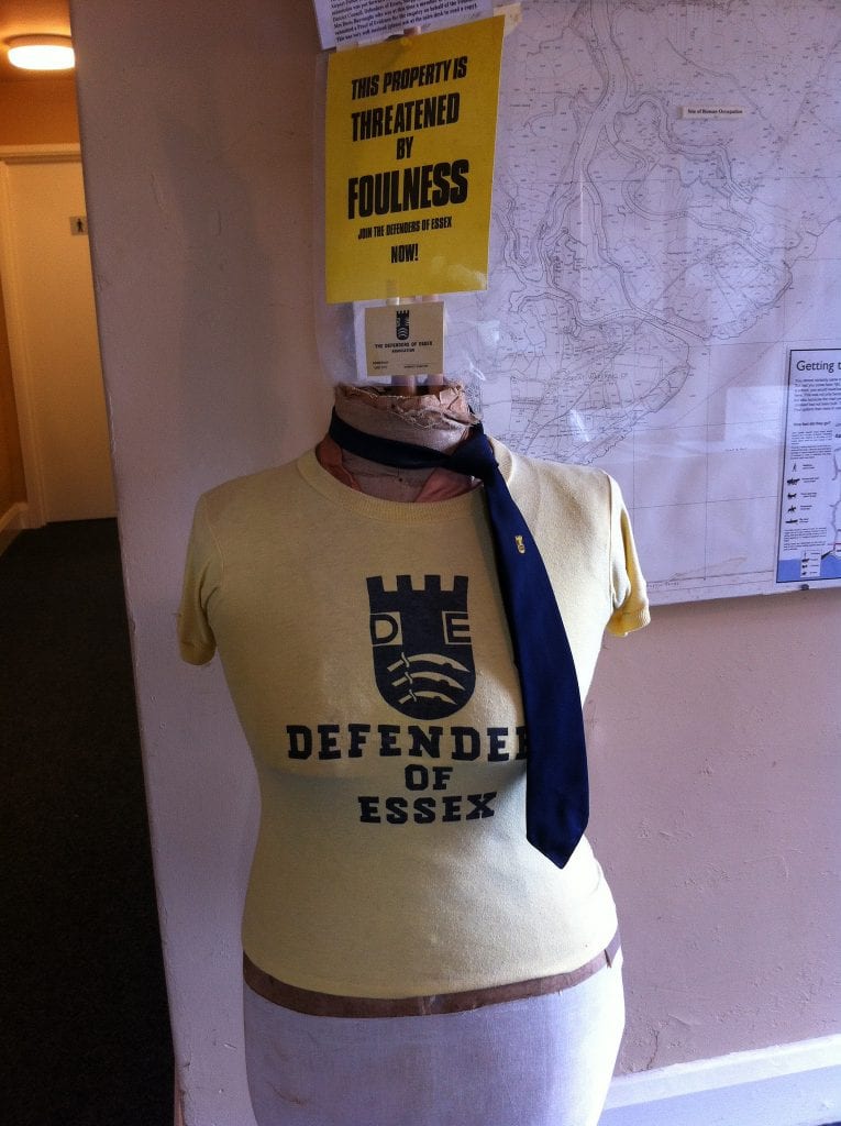
Figure 6. The Defenders of Essex opposed the Maplin Sands airport proposal, 1968-1974. On display at Foulness Heritage Centre.
Despite the emphasis on the historical, and indeed the presence of the monstrous and the threatening, there is no representation, understandable perhaps in the context of extreme secrecy, at the Foulness Heritage Centre, of the extraordinary nuclear work of the island.
(2) Atomic Foulness
There are two main secondary sources on military research at Foulness: Wayne Cocroft and Sarah Newsome’s archeological survey for English Heritage, published online (1), and B.G. Eunson’s incompletely declassified draft history (2). Cocroft and Newsome draw on primary sources as well as Brian Cathcart’s Test of Greatness (1994). Eunson’s partial history was not available when Cocroft and Newsome were writing their report.
In the mid-19th century, the Board of Ordnance tested rockets from Shoeburyness onto the Maplin Sands (some have been recovered and can be seen in the Smithsonian, here is probably an example). Testing larger artillery required more space, and ranges to the immediate south-east of Foulness (Havengore and New England islands) began to be used. It was part of a network of sites coordinated from the Royal Arsenal, Woolwich’s Research Department (later moved to Fort Halstead in Kent, and renamed the Armament Research Department). From 1923, Eunson records that when Havengore island began to be used, part of the set up was a ‘mobile laboratory – a converted railway wagon, painted white – which was taken by rail to Shoeburyness and thence to Havengore … for trials that could not be accommodated in the small bomb chambers at Woolwich’ (2). In the Second World War, the War Office’s Armament Research Department used Havengore alongside another site at Millersford in the New Forest in Hampshire. Millersford had a restriction of 500 lb for a bomb or 1,000 lb for a bare charge, and so Havengore (where there were no restrictions) was used for larger explosive charges. The scientist in charge of Millersford was Roy Pilgrim.
Post-war, Millersford had to be returned to the commissioners of the New Forest. The Ministry of Supply, responsible for the Armament Research Department, decided that work would be concentrated at Foulness, and acquired land.
In January 1947, Attlee’s secret cabinet committee took the decision to build a British nuclear bomb. Willam Penney, who had been involved with the Manhattan Project and was Chief Superintendent Armaments Research at Fort Halstead, led the team. Like the wartime British ‘Tube Alloys’ and American ‘Manhattan’ projects, it had a misleading title: Basic High Explosives Research (HER). Foulness from 1948 became an integral part to the new network of UK atomic weapon sites: Risley in Cheshire produced the fissile metals plutonium and uranium as well as polonium for the initiator; necessary research was conducted at Harwell in Oxfordshire; the high explosive lenses were machined at Woolwich; other parts came from Royal Ordnance Factory at Chorley, Lancashire, and the Percival Aircraft Company of Luton, Bedfordshire, the whole would be co-ordinated first from Fort Halstead and then from the bespoke headquarters at Atomic Weapons Research Establishment (AWRE) Aldermaston in Berkshire.
Foulness would be where the whole came together. In early summer 1952, in the Explosives Preparation Laboratory, after practising with a concrete mock-up Alfred, the first three British atomic bombs, Hero, Hengist and Horsa, were assembled, with the high explosive lenses being placed around Aldermaston’s plutonium core, completing the devices. Transported by lorry, barge and frigate to the Monte Bello islands, located off the north-west coast of Australia, one of these devices was detonated on 3 October 1952, the Hurricane test.
The British atomic bomb project had been announced in 1948, over a year after it had begun in secret. Foulness’s nuclear role was publicly admitted (probably inadvertently, say Cocroft and Newsome) in 1954 when a job advertisement mentioning AWRE Foulness appeared in Nature (3). The recruitment was part of a large expansion of nuclear work at Foulness in response to the decision, taken in 1954, to build a British hydrogen bomb. Only a year after the Great Flood, £500,000 was spent on new buildings, and an increase in staff was planned, from 297 in 1954 to 408 by March 1955 (4). Even so, Foulness began to run out of space for safe testing, and this realisation prompted the decision to build further facilities at Orfordness on the Suffolk coast.
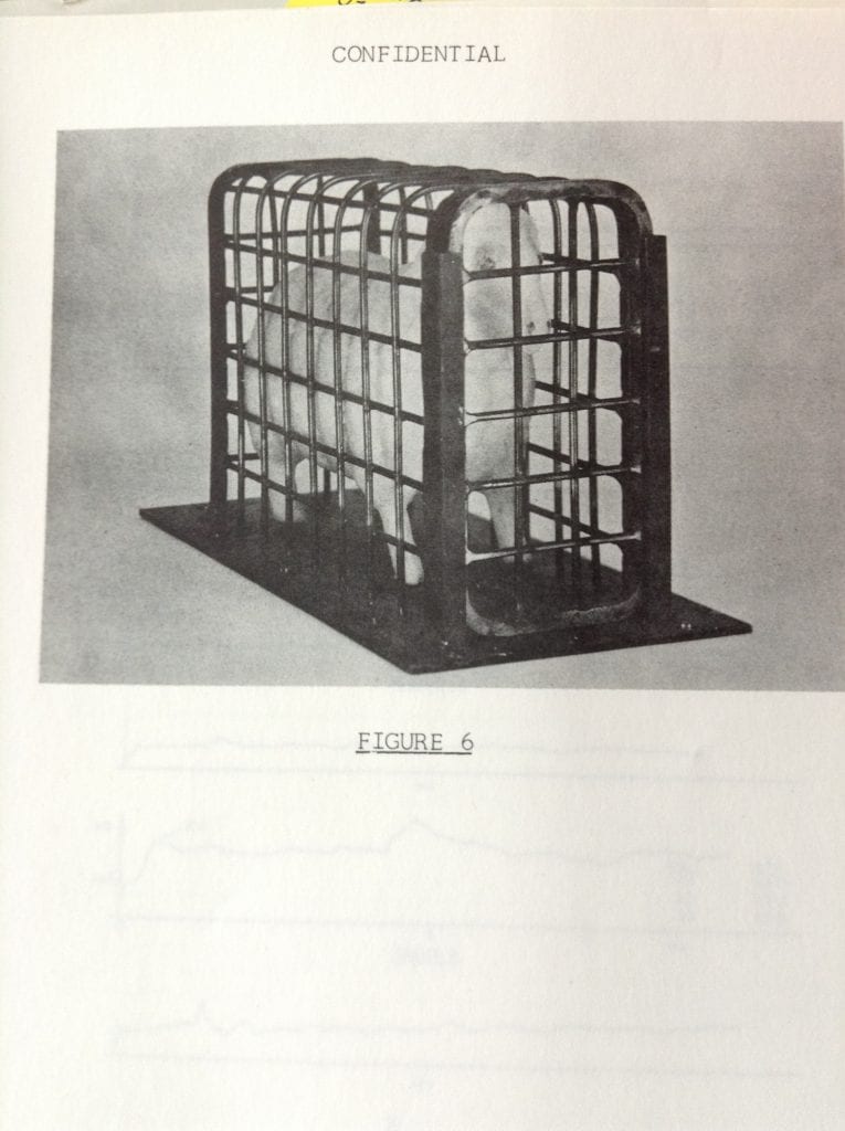
Work at AWRE Foulness was varied, and widely distributed across different ranges. In addition to the assembling of the first British nuclear bombs, scientists developed monitoring instruments, tested to destruction Magnox reactor vessels for civil nuclear power, investigated the effects of nuclear blasts and shock waves using scaled down models (of buildings and of organisms, see Figure 7), including work on the planned silos for the Blue Streak missile, and tested components of the nuclear weapons that were in fact deployed: Polaris, Chevaline and Trident. Major experimental instruments include a large Air Blast Simulator – 206m in length, built in the 1960s, probably because the Partial Test Ban Treaty of 1963 had prohibited atmospheric nuclear explosions – an Underwater Range, built around a 38 foot square concrete pond, a Compressed Air Launcher, a Thermal Radiation Facility, a Spigot Intrusion Test Facility (essentially a large gantry arm from which explosives were dropped on to a steel plate), Shock Tubes (including one 44m in length), as well as numerous laboratories, casting shops, and test buildings (5). One shock tube, planned in 1957, was justified as follows:
The shock tube will be used to make three dimensional studies of the diffraction of blast on structures and models, the blast being a scaled equivalent of that produced by the explosion of a megaton weapon. (6)

Figure 7. A model sheep in the Foulness Shock Tube, 1964. From NA ES 3/77. AWRE Report no. E7/63 (7). This was preliminary work in advance of a 500 ton TNT test at Suffield, Canada.
The research on the effects of nuclear blasts was particularly important in a diplomatic context, since, the results were ‘a crucial intellectual commodity’, one of the few areas where following the US 1946 McMahon Act, atomic knowledge ‘could be exchanged with the United States, and thereby maintaining links with its nuclear science community’ (8). Toys were not the only gifts passing across the Atlantic in the 1950s. Indeed the thermonuclear work can be understood in similar terms; the British H-bomb project was largely pursued with the aim of reopening full US-UK nuclear relations in the event of a successful test.
While atomic work ended at Foulness in 1997, the AWRE site is closed to the public, for reasons of contamination (not least from toxic beryllium, foul-ness of a different kind) and stray munitions as much as continued secrecy. A visitor to the island travels along the main road, passing the entrance of AWRE Foulness on the left. Following the route on the map below, which dates from the time of thermonuclear expansion after 1954, the visitor starts at the bottom left, crossing Havengore and New England islands, and passes the entrance, where what is now called Pilgrim Way leads into the AWRE site. If you were to drive along Pilgrim Way, you would pass side roads on the left that lead to Range 1, Ranges 4, 3 and 6, Ranges 2 and 7 and then Ranges 8 and 9. A side road to the right leads to Ranges 5, 10 and 11. The next road on the right takes you to the Magazine Area, which contains the Explosives Preparation Laboratory where the Hurricane test bomb was assembled. Finally one reaches the Headquarters, safely at a distance from the ranges, where there were offices, a canteen, a computer centre, as well as laboratories and workshops.
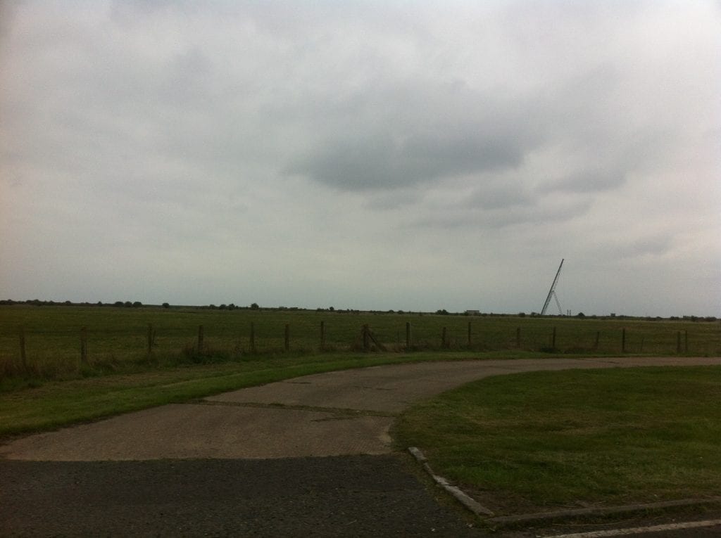
Some of the larger experimental structures can be glimpsed from the road, including the gantry of the Spigot Intrusion Facility near Range 11 and (probably) one of the blast simulators or shock tubes.
All this work required infrastructure in addition to buildings and facilities. The 1954 expansion needed a new electricity supply, which in turn called for pylons or underground cables (9). Drinkable water was always a problem. An artesian well, present by the 1830s, had to reach down 460 feet to reach fresh water, the deepest in Essex (10). In 1958, AWRE Foulness’s water needs were described as ‘beyond question’:
Our current consumption of water is up to 28,000 gallons daily and we expect shortly a 25% increase. The bore-holes which serve our enclave as well as the Ministry of Supply establishments … have capacity of 34,000 gallons per day. We have managed only by the use of storage tanks which fill up at night and at weekends but, despite the most rigid economy in the use of water, the tanks run very low by the end of each week, and the medical authorities are already concerned at the quality of the water. (11)
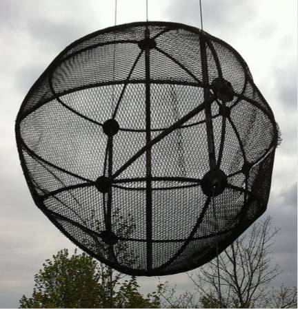
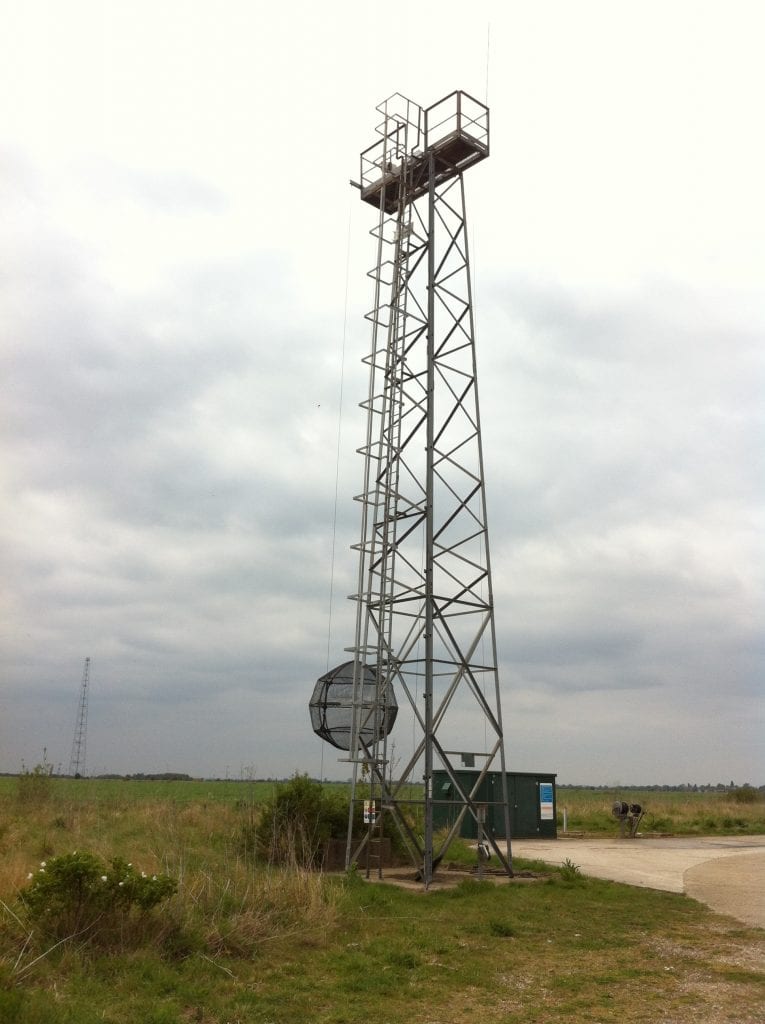
The Ministry of Supply establishment mentioned here included the outpost of the Royal Armament Research and Development Establishment at Potton Island, to the west, as well as continuing trials on the eastern half of Foulness adjoining Maplin Sands and the North Sea. One of the few structures a public visitor can examine closely is an aerial tower with radar ball, which naval ships in the North Sea would target during artillery tests (see Figure 10)
Elsewhere on the island (to the far north of the AWRE site and closer to the civilian population at Churchend) an Environmental Test Centre opened in the 1960s, part of the (now) Ministry of Defence’s Proof and Experimental Establishment, the main site of which was at Shoeburyness.
Not much is known about the feelings of Foulness residents – mostly farmers, their family and employees – to the expanding military activity on their island. Essex residents on the mainland certainly did complain. Unsightly pylons were opposed in the 1950s (not least because there was already one set marching across the land towards the Bradwell nuclear power station being built on the Dengie peninsula, north of Foulness) (9). But a more serious problem was noise. Detonations rocked houses and even broke windows many miles away. Following the admission that Foulness was undertaking atomic work, complaints increased. The Southend-on-Sea and District Trades Council wrote en masse, saying they were ‘extremely concerned at the danger to Southend and district of the Atomic Experimental station’. One resident of Burnham-on-Crouch wrote to his MP, Tom Driberg, asking
for an explanation of the recent explosions which have at times shaken this town recently. For instance last evening at 8.0 pm and 8.25 pm there were two huge “bangs” which shook this house. Surely my wife and children can expect a normal nights sleep and my wife not be expected to comfort them for a time after each bang! Cannot these experiments as such be carried out in the day time? (12)
It’s telling that this correspondent clearly considered the detonations justified, merely inappropriately timed. (Tom Driberg, on the other hand, would soon become a prominent campaigner against thermonuclear weapons.) A resident of Rochford, Essex, cunningly dressed up his complaint as a suggestion about security:
Since the government has seen fit to build a research station on Foulness, will it also recompense us for any damage sustained to houses as a result of blast, etc…?
I am not a person to question the opinion of Sir William Penney but there are far more secluded areas on the coast of Scotland where such a station could be built.
There may only be a few people on the island but I do not think it is so secluded as the Government thinks.
There are many waterways including the Crouch and the Roach by which the island can be reached, to say nothing of foreign vessels calling at Canewdon.
Also what is to prevent aircraft sighting the station[?].
One has only to live in this road to know that traffic is still leaving the coast at 3 o’clock in the morning
There are no coastguards in the area and I still say that, under cover of darkness, Foulness island is still open. (13)
All such complaints were met with fairly frank replies, saying that the work was necessary, only involved high explosives (‘no nuclear explosions have been or will be made’), and any proven damage recompensed. (14)
Finally, a more conciliatory interest – spanning residents, and civil and military government agencies – was found in nature. The remoteness of Foulness was as attractive to wildlife as it was to military researchers. Birds flocked to island, especially in winter, despite the occasional bangs. In the mid 1970s, the Nature Conservancy Council (NCC) co-ordinated a Conservation Group, which reached out to residents of Foulness to help record species, maintain ponds, plant trees, and negotiate rabbit control. (15). The RSPB had been impressed by the response of AWRE staff to an archeology display, and wondered whether something similar could be produced ‘for the birds’: it ‘would be lovely to get Sandwich terns back, especially as they are probably doing worse than little terns at the moment’. There may have been disputes – for example over whether parts of New England island should be returned to arable use or conserved for wildlife – but it was also noted that ‘the farmers have a greater knowledge of the land and its wildlife than the members of the NCC’. (16) As the military authority wrote, even though Foulness was ‘engaged on work of a classified nature, and at the same time being a closed firing range’, ‘we do have a common ground of interest regarding conservation’ (17). As a 1990s valedictory article in the AWE (Atomic Weapons Establishment) News-Link began:
With the end of the Cold War another chapter closes… Boundaries can be mysterious and challenging places, and nowhere is this more true than at an estuary where a tired rive mingles slowly with the sea amid marsh and salt flat. Often surrounded in mist or scoured by biting winds, haunted by sea birds and open to immense skies, an estuary might seem to be one of the last strongholds of nature. … Yet here there is evidence of human occupation over many hundreds of years, from Roman settlements to the facilities constructed as part of Britain’s campaign to develop an independent nuclear deterrent. (18)
The title of the article: the ‘Fascination of Foulness’.
(1) Wayne Cocroft and Sarah Newsome, Atomic Weapons Research Establishment, Foulness, Essex. Cold War Research & Development Site. Survey Report. Portsmouth: English Heritage, 2009.
(2) B.G. Eunson, ‘AWRE Foulness: a unique establishment’, second draft, 1986. Parts are available in National Archives (NA) ES 17/27 (opened February 2017) and probably earlier draft chapters and appendices ES 17/13 (opened May 2016).
(3) Cocroft and Newsome, p. 13. I haven’t found this advertisement. But a search uncovers a vacancy for a ‘General Experimental Physicist, Principal Scientific Officer or Senior Scientific Officer grade’ for UKAEA, contact AWRE, in Nature (12 February 1955, p. 312) and further experimental officers the same month.
(4) Cocroft and Newsome, p. 21.
(5) Cocroft and Newsome, p. 38, p. 45, p. 55, p. 82.
(6) ‘Large shock tube at Foulness’. Bundy to Hudspith, 17 October 1957. TA AB 16/1777. ‘Such tests cannot be measured by usual scale model methods as the fall of rate in pressure is too rapid. The tube will be used to assist in the dynamic calibration of pressure gauges for use in local and overseas trials’, but also for the design of shelters.
(7) NA ES 3/77. K.F. Mead and J.E. Uppard, ‘UKAEA. AWRE. AWRE Report no. E7/64/ Preliminary shock tube work performed at Foulness for 500 TNT at Suffield 1964’, January 1965.
(8) Cocroft and Newsome, p. 16.
(9) NA AB 16/1777. AWRE to Wheldon (Finance Branch, UKAEA), 4 July 1957.
(10) ‘Science news a century ago. Wells in the London Clay in Essex’, Nature (20 May 1939), p. 866. The news item recalled a paper presented by Dr Mitchell to the Geological Society on 22 May 1839.
(11) NA AB 16/1777. Hudspith to Thompson, 2 September 1958.
(12) NA AB 16/1313. Nicholls to Driberg, 8 July 1954.
(13) NA AB 16/1313. Ramsey to McAdden, 29 March 1954. McAdden was another local MP.
(14) NA AB 16/1313. Lord Salisbury to McAdden, 28 April 1954. In another letter, Peirson to Tourtoulon, 24 April 1954, the Southend-and-District Trades Council were read an extract from Hansard: ‘The Foulness Range has been used over some years by the Atomic Weapons Research Establishment, for experimental work with conventional high explosives. The work is an essential step in the development of atomic weapons. The explosions are also used to study the effects on model structures and so provide valuable data for those forms of Civil Defence. I can definitely say that no nuclear explosions have been or will be made, nor will experiments be made with fission products or any other hazardous radioactive material’.
(15) NA DEFE 72/207. ‘Foulness Conservation Group’, meeting 9 September 1975.
(16) NA DEFE 72/207. Griffiths, ‘Notes of a meeting held in the Parish Hall on Foulness Island on 18 November 1975’, November 1975.
(17) NA DEFE 72/207. Colonel G.B.R. Horridge to J.M. Johnston, December 1976.
(18) NA ES 17/27. ‘Fascination of Foulness’, AWE News-Link, undated (1990s).
2 Responses to “Foulness”
- 1
-
2
A M Wardle wrote on 18 June 2020:
A fascinating read. These isolated east coast former Cold War scientific sites like Foulness and Orford Ness have a real air of mystery about them. Great to find a well researched article filling in some of the blanks.
 Close
Close



HI
I have some clients who need good sites so we have found your site which is good but our budget
is not high so please give us price for https://blogs.ucl.ac.uk
link zin
we will pay you through paypal
need time for paying 3 to 4 days because only need verification from client
you can trust on us because we will not cheat you as we receive payment from client we will forward you.