The real-life places named as settings in French-language lais: click here for link to a full-size map with further information about each place.
A sense of place is an essential part of Breton lais. A quick glance through the opening lines of several tales suggests that the storytellers felt it important to reveal not only what happened in their chosen aventure, but where it happened. The fairy-mistress story Guingamor, for instance, opens by declaring that En Bretaingne oi .I. roi jadis, ‘there once lived a king in Brittany’; the delicately macabre Laüstic sets itself En Seint Mallo en la cuntree, ‘in the region of St Malo’, where Ot une vile renumee, ‘there was a famous town’; the tragic Deus Amanz, meanwhile, begins by telling its audience that Verité est ke en Neustrie,/Que nus apelum Normendie,/Ad un haut munt merveilles grant, ‘The truth is that in Neustria, which we call Normandy, there is a marvellously high mountain’. Very often, the warp and weft of landscape and story are closely woven together into the lai narratives.

Coast of Brittany
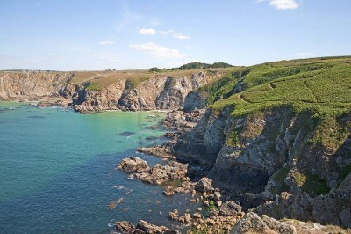
A large number of lais are set in the Celtic areas of Britain and northern France: Wales, Scotland, Ireland, Cornwall, and, above all, in Brittany, where (as Marie de France and other lai writers declare) stories of adventures and marvels were transformed into lais for posterity by the ancient Bretons. Whether or not all stories credited as ‘Breton lais‘ were truly taken from old Breton tales, a Celtic background was adaptable for a variety of storytelling purposes, imbuing any stories set in such places with what medievalist Christopher Page has called ‘Celtic mystique’. When told in French by the Anglo-Norman speakers of post-Conquest England, or the courtiers of continental France, beginning a story with ‘In Breteyne bi hold [old] time’ (the word ‘Breteyne’ could stand either for Britain or Brittany) could immediately evoke an atmosphere of a semi-mythical, just-out-of-reach past, set in a northern European landscape of forests, mountains and rocky coasts which was both familiar and – when viewed through the sea-misted lens of Breton stories originally told in ‘hir firste Briton tonge’ – enticingly exotic.

La Cote des Deux Amants
However, the majority of lais are also set in real places within these Celtic realms, lending them a concrete geographical specificity alongside the fantastical events they describe. Three lais (Chaitivel, Equitan and Tyolet) take place in Nantes, one of the major cities of the historic province of Brittany. Meanwhile, a Normandy-based tale, Marie de France’s Deus Amanz, is set in the city of Pîtres on the Seine. The events of this tale are reflected today in place-names of the area; a hill overlooking the river is named the Côte des Deux Amants, and is said to be the one climbed by the lai‘s unfortunate hero, and a nearby lake (and campsite) takes the same name.

Carlisle Castle
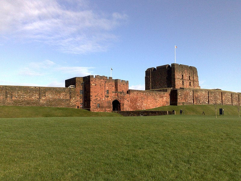
Of the British locations, a handful are set in Scotland (Doon, Trot, Desiré), with a couple in the northern borderlands of Northumbria and Carlisle. As the story of Lanval opens, King Arthur is holding his court in Carlisle, ‘pur les Escoz e pur les Pis/Ki destruient le païs’ (because of the Scots and Picts who were destroying the country). Founded by the Romans to serve the forts on Hadrian’s Wall, Carlisle’s proximity to the Scottish border made it a strategically important English base throughout the Middle Ages and beyond. Reflecting this, Carlisle was a popular location for Arthur’s court of Camelot in medieval tradition, and is used as a setting in several Arthurian romances. The largest number of Britain-based lais, however, are associated with South Wales (Chevrefoil, Cor, Milun, Yonec). The knightly heroes Milun and Tristram are described in the lais as coming from that region. Linguistically and politically separate from England in post-Conquest Britain, Welsh material found its way into French-language works, possibly in part through Welsh-speaking ‘latimers’, or professional interpreters working for the Anglo-Norman government. Medieval scholar Constance Bullock-Davies has raised the possibility that one source of Celtic material for Marie de France may have been from a latimer attached to a noble household.
However, as the map shows, a scattering of other locations are referred to, all from the Mediterranean and Middle East. In Les Deus Amanz, the Italian city of Salerno is named as the home of the heroine’s aunt. Wishing to give her beloved the necessary stamina to carry her up a steep hill (the challenge set by her father before they can marry), she urges him to visit her aunt, a skilled practitioner of medicine, for a strengthening potion. Salerno had a strong association with medicine in the Middle Ages, being the site of a famous medical school, and was particularly associated with women healers; the popular compendium of women’s medicine, the Trotula, was traditionally attributed to a woman from this area. Lais with Classical rather than Celtic themes, meanwhile, are set in the locations of their original tales, taken from Ovid’s Metamorphoses, Thebes (Narcisus et Dané) and Babylon (Piramus et Tisbé).
The map I’ve created of lai settings allows you to see all the real-world places named in Breton lais. Clicking on each place name will give you more information about each place and the story associated with it. So far, I’ve just added the places named in French-language lais; in time, I’ll make separate maps giving the places named in the lais of different language traditions. The English and Norse translators sometimes altered the settings to suit their audiences (the English version of Fresne, for instance, moves the action from Dol-de-Bretagne to ‘the west cuntré’ of Britain, and the Norse translator of Bisclavret adds a touch of local verisimilitude with the detail that ‘He who translated this book into Norse saw in his childhood a wealthy farmer who shifted his shape’).
I hope you enjoy the map – it’s still a work in progress, as I think about different ways of mapping Breton lais, and about the relationship between landscape, the lais themselves, and the journeys made by lais and similar stories across Europe both orally and in manuscripts, so I’d be happy to hear any suggestions or comments!
Further reading:
Constance Bullock-Davies, Professional Interpreters and the Matter of Britain: A Lecture delivered at a Colloquium of the Departments of Welsh in the University of Wales at Greg ynog, 26 June, 1965 (Cardiff: University of Wales Press, 1966)
Christopher Page, Voices and Instruments of the Middle Ages: Instrumental Practice and Songs in France 1100-1300 (London: J. M. Dent & Sons, 1987)
 Close
Close