X Close

The Survey of London

Home

Recording the history of London's built environment since 1894

Menu

Archive for the 'South-East Marylebone' Category

The Queen’s Hall, Langham Place

By the Survey of London, on 12 February 2016

Queen's Hall roundels

Portrait busts of great composers lying amidst rubble after the Queen’s Hall was hit by an incendiary bomb in 1941 (Photograph by Larkin Brothers Ltd., reproduced by kind permission of the Royal Academy of Music). If you are having trouble viewing images, please click here.

Handel, Haydn and Weber lying with other great composers’ names and profiles amidst ruin and dereliction: this poignant photo, taken around 1954, shows remnants of the Queen’s Hall, Langham Place, Marylebone, at the time of its final demolition. The building had been gutted by an incendiary bomb on the night of 10 May 1941, but like many blitzed buildings in London its shell lingered on into the 1950s.

The Queen’s Hall was the perfect concert hall for London’s musical life, something which now only a very few can remember. Famously, it was the first home of the Proms. Everyone who played or sang or went to concerts there recalled its intimate atmosphere and acoustics with great affection. Before it was built in 1890–3, large-scale orchestral or choral concerts and recitals were held in multi-purpose halls like St James’s Hall, Piccadilly, with few facilities for performers and little by way of outward architectural show.

exterior view of queen's hall seen from langham place queen's hall opened in 1893 as a concert hall and was designed by architect t e knightley. it was later destroyed by an incendiary bomb in 1941. queen's hall greater london city of westminster westminster

The Queen’s Hall seen from Langham Place, photographed in 1894 by Bedford Lemere and Co. (Reproduced by kind permission of Historic England).

The Queen’s Hall was different. Projected on a prominent site between All Souls, Langham Place and another forgotten musical venue, St George’s Hall, it was built at the sole expense of Francis Ravenscroft, who had made a great deal of money from the Birkbeck Bank. Ravenscroft seems to have had no special interest in music, but his lawyer J. S. Rubinstein did, and it is a fair bet that the idea to invest his client’s money in a modern concert hall for London came from him. Once that decision had been taken, Ravenscroft did not stint, giving his main architect, T. E. Knightley, the chance to design not only a grand concert hall to a horseshoe plan with a smaller recital room on top, but also a spectacularly lavish monumental frontage in stone on a curve, with a deep colonnade and lashings of carving. It was there, tucked into niches, that the composers featured, some as complete busts, others in high profile.

Screen Shot 2016-02-11 at 10.10.49

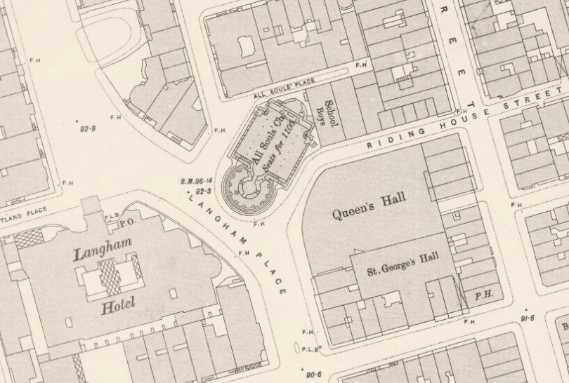
Extract from the 2nd-edition OS map, published 1895, showing Langham Place with the Queen’s Hall next to All Soul’s church and opposite the Langham Hotel (Reproduced by permission of the National Library of Scotland).

The photograph at the top of the page shows only some of the abandoned composers in profile (the complete set consisted of Brahms, Gluck, Handel, Mendelssohn, Wagner and Weber). By then the full busts (Bach, Beethoven, Haydn, Mozart, Purcell and Tchaikovsky) had probably been rescued by the St Marylebone Society with the aid of the Royal Academy of Music. For years they adorned the garden of a cottage in Olney, Buckinghamshire, shared by the violinist and teacher Rosemary Rapaport and Sir Thomas Armstrong, former Principal of the Royal Academy of Music. They were returned to the Academy in 2001 after restoration, and can now be seen in its museum on the Marylebone Road. They are the sole physical reminders of a famous and much-loved London institution, where leading musicians from all over the world played and many famous meetings were also held. The best evocation of the Queen’s Hall and its atmosphere can be found in E. M. Forster’s Howards End, including a nicely sarcastic description of its French ceiling painting showing ‘attenuated Cupids … clad in sallow pantaloons’. That had been painted out well before the fatal bombing of 1941.

(© Survey of London and Historic England, Andy Crispe)

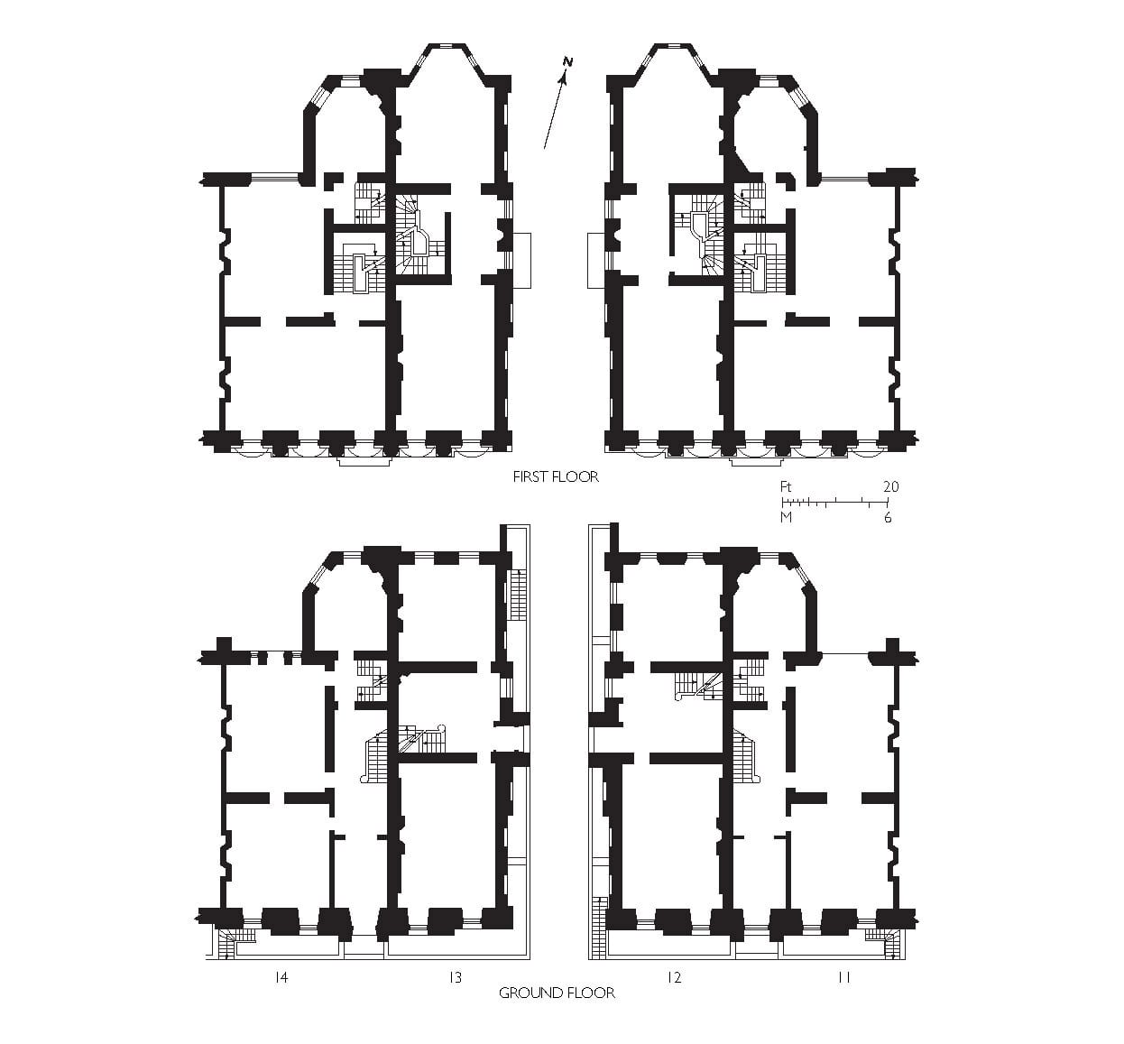
Plans of the main hall and small hall of the Queen’s Hall, Langham Place. Please click on the picture to expand (© Survey of London and Historic England, Andy Crispe).

Mews Views

By the Survey of London, on 5 February 2016

Back in Marylebone, the subject of today’s post is the numerous mews that are significant hyphenations of the great regular grid of streets that is bracketed by Wigmore Street, Marylebone High Street, the Marylebone Road and Portland Place – the core, that is, of the Howard De Walden Estate. It is an irony that the latter-day charm of these places, which were designed in effect for the parking of coaches and horses, rests largely in their residential calm and relative freedom from vehicles.

Laid out with the streets in the later decades of the eighteenth century, they were characteristically sett-paved and originally lined by low (almost invariably two-storey and plain stock brick) rows of stables and coach-houses with living space above for associated servants. If there was architectural finesse, it faced the gardens of the houses, not the mews. There were piecemeal early rebuilds, but change appears to have been humble and in keeping until the 1890s (Thomas Woolner’s studio of 1862 in Marylebone Mews being an interesting exception). Around then a new type appeared, a variation where access to the upper living space was made separate by virtue of external stairs across the front, facilitating occupancy by those who had nothing to do with the horses. Soon after, motor garages appeared, as conversions and in some cases as purposeful rebuilds.

The early and middle decades of the twentieth century saw increasingly ambitious and concerted interventions, more expressly residential if always above parking. A good deal of this was due to two property developers, William Willett and Henry Brandon, who insinuated stronger elements of architectural style, ranging from variations on the Neo-Georgian to the Neo-Tudor.

After the Second World War residential and gentrifying conversions that began to diminish ground-floor vehicle cover led to gradual prettification through paint, stucco, glazing bars, carriage lamps and window boxes. Through the same post-war decades there were a few substantial Modernist redevelopments, occasionally for office or institutional use. Residential use remains the rule and basements are being excavated. The most recent replacement buildings are yet more self-consciously architectural than any of their predecessors.

(© Historic England, Chris Redgrave)

Devonshire Mews West, Nos 27 to 36 on the east side from the south, showing a frontage that has its origins in the 1820s, the London Clinic beyond (© Historic England, Chris Redgrave). If you are having trouble viewing images, please click here.

(© Historic England, Chris Redgrave)

29 Devonshire Mews West, a rare unreconstructed garage (© Historic England, Chris Redgrave).

(© Historic England, Chris Redgrave)

37-38 Devonshire Mews West, 1956–7, Basil Hughes and Bonfield, architects, garages under two flats for the Howard De Walden Estate (© Historic England, Chris Redgrave).

(© Historic England, Chris Redgrave)

39 Devonshire Mews West, 1908–9, with independent access to an upper-storey flat by means of an external staircase (© Historic England, Chris Redgrave).

(© Historic England, Chris Redgrave)

Devonshire Close, showing Neo-Georgian brick at No. 15 (left), 1924 for William Willett with Amos Faulkner, architect, and Neo-Tudor black-and-white at Nos 12 and 14, 1935-9 for Henry Brandon with Alfred and Vincent Burr, architects (© Historic England, Chris Redgrave).

(© Historic England, Chris Redgrave)

30-35 Devonshire Close, rebuilt for clients ranging from Major H. A. Wernher at No. 30 in 1922-3 (right) to Vincent Gluckstein in 1926 at No. 34. Willett and Faulkner were responsible for the gabled profiles of Nos 33 (1910-12) and 32 (1920), Moore-Smith & Colbeck, architects, for No. 31 in 1930-1 (© Historic England, Chris Redgrave).

(© Historic England, Chris Redgrave)

Devonshire Mews South, sett paving and two-storey rows that have their origins in the 1780s, with the London Clinic again looming up to the north (© Historic England, Chris Redgrave).

(© Historic England, Chris Redgrave)

107 Devonshire Mews South, a 1900ish rebuild with external stairs, altered in 1954 and since (© Historic England, Chris Redgrave).

(© Historic England, Chris Redgrave)

34 Devonshire Place Mews, another stabling rebuild with a former forage-store opening to an attic that has been converted. Mansard roofs are fairly ubiquitous (© Historic England, Chris Redgrave).

(© Historic England, Chris Redgrave)

Wimpole Mews, the east side from the south, showing No. 6 (right) of 1904 with shaped parapet, built for Walter Hamilton Hylton Jessop, an opthalmic surgeon of 73 Harley Street, with William Henry White as architect. For No. 8 beyond, see below (© Historic England, Chris Redgrave)

(© Historic England, Chris Redgrave)

No. 8 Wimpole Mews,  rebuilt in 2011–12 for the Howard De Walden Estate to plans by Urban Mesh Design Ltd (© Historic England, Chris Redgrave).

(© Historic England, Chris Redgrave)

33 Weymouth Mews, 1898, by and for Waterhouse & Son, the architects Alfred, then elderly, and his son and partner, Paul, who were based in an adjacent New Cavendish Street property (© Historic England, Chris Redgrave).

St Peter’s, Vere Street

By the Survey of London, on 15 January 2016

The small brick church that is St Peter’s, Vere Street, stands just north of Oxford Street, tucked away behind department stores, as inconspicuous as its larger sibling, St Martin-in-the-Fields, is prominent. This modest place of worship was built in 1721–4 as the Oxford Chapel, a private undertaking for the 2nd Earl of Oxford and Mortimer, Edward Harley, who, through marriage to Lady Henrietta Cavendish Holles, had inherited extensive lands north of Oxford Street that were then just beginning to see building development. The architect of the estate chapel was James Gibbs, otherwise associated with the Harley family, and resident across what was then Henrietta Street (now Place) in a new house of his own devising from 1732.

St Peter's, Vere Street from the north-west (© Historic England, Chris Redgrave)

St Peter’s, Vere Street, from the north-west (© Historic England, Chris Redgrave). If you are having trouble viewing images, please click here.

The interior of the chapel, while indebted to Christopher Wren for its basic forms, was in its particulars what John Summerson termed a ‘miniature forecast’ of St Martin’s. [1] Corinthian arcades carry an elliptical nave vault to cross-vaulted aisles, and once private galleries overlook the chancel. In 1734 Edward and Henrietta’s only child, Lady Margaret Harley, married the 2nd Duke of Portland in the chapel. From that marriage the valuable landed estate descended to and took its name from subsequent Dukes of Portland, later passing to Lord Howard de Walden.

(© Historic England, Chris Redgrave)

The chancel from the south-west (© Historic England, Chris Redgrave)

The proprietary chapel was acquired by the Crown in 1817, part of a peculiar arrangement to divest the Portland Estate of surplus ecclesiastical capacity. After a general overhaul it was dedicated to St Peter in 1832. Victorian alterations were of a generally high calibre, and included stained-glass windows by Edward Burne-Jones, all made by Morris & Co., that remain in place. The window at the centre of the south aisle gallery commemorates James Golding Snelgrove, a son of John Snelgrove (co-owner of the Marshall & Snelgrove department store on Oxford Street), who died aged sixteen. Below gallery level is a smaller companion window showing the ‘Reception of Souls into Paradise’. Burne-Jones noted the job in an account book, laden with mock outrage:

‘Large cartoon of Christ entering Jerusalem – for church of SS Marshall & Snellgrove [sic] – another masterpiece charged on so mean a scale of remuneration that I am reluctant to put on record so disgraceful a piece – nothing is so injurious to art as these contemptible prices – they keep alive the dishonest tendencies of the time more than can easily be said.’ [2]

The twentieth century saw gradual decline and after a protracted period of dry rot, de-Victorianizing and muddle, the church was adapted in 1982–3 for office use by the London Institute for Contemporary Christianity, which continues in occupation.

(© Historic England, Chris Redgrave)

The Burne-Jones stained-glass window at the centre of the south aisle gallery, depicting ‘The Entry into Jerusalem’, dates from 1883 (© Historic England, Chris Redgrave)

(© Historic England, Chris Redgrave)

One of a pair of windows on the north side of the church, on the theme of Faith, Hope and Charity. The window was dedicated to John Snelgrove and made following his death in 1903 by Powells, possibly to designs by Henry Holiday (© Historic England, Chris Redgrave)

The photographs for the Survey of London’s account of the south-eastern parts of the historic parish of St Marylebone are by Chris Redgrave, of Historic England. As an additional complement to our investigations, Andy Crispe, also of Historic England, has prepared a fly-through visualization of St Peter’s. We are pleased now to be able to make this publicly available.

Oxford Chapel 3D reconstruction by Andy Crispe from Survey of London on Vimeo.

References

[1] John Summerson, Georgian London, 2003 edn, p. 99

[2] Douglas E. Schoenherr, ‘Edward Burne-Jones’s Account Books with Morris & Company (1861-1900): an annotated edition’, Journal of Stained Glass, vol. 35, 2011

Cavendish Square 2: Nos 11-14

By the Survey of London, on 8 January 2016

This is the second in what will be an occasional series of posts about Cavendish Square. The north side of Cavendish Square has symmetry about its centre. This reflects the prominence of the elevation in relation to the square’s common axis along Holles Street to Hanover Square, a coherent piece of town-planning across two landholdings that is unusual for early eighteenth-century London. But the axis was the extent of the coherence then achieved. The Duke of Chandos’s plans for a full-width palace across Cavendish Square’s north side fell by the wayside when much of his fortune evaporated. Instead he built two big houses at either end and left the middle of the square’s show frontage empty save for use as a rubbish dump. This failure was excoriated by James Ralph in the Critical Review in an account of the square in 1734:

‘… there we shall see the folly of attempting great things, before we are sure we can accomplish little ones. Here ’tis, the modern plague of building was first stayed, and I think the rude, unfinish’d figure of this project should deter others from a like infatuation. When we see any thing like grandeur or beauty going forward, we are uneasy till ’tis finish’d, but when we see it interrupted, or intirely laid aside, we are not only angry with the disappointment, but the author too: I am morally assur’d that more people are displeas’d at seeing this square lie in its present neglected condition, than are entertain’d with what was meant for elegance or ornament in it.’ [1]

Howard de Walden Project. General view of Cavendish Square, Marylebone, Greater London. View from south.

Cavendish Square in 2013, with a view through the trees to Nos 11-14 (© Historic England, Chris Redgrave). If you are having trouble viewing images, please click here.

Extract from the Ordnance Survey First Edition map of Middlesex XVII, showing Cavendish Square and Hanover Square c. 1870 (Reproduced by permission of the National Library of Scotland)

Extract from the Ordnance Survey First Edition map of Middlesex XVII, showing Cavendish Square and its environs, including Hanover Square, c. 1870 (Reproduced by permission of the National Library of Scotland)

So things rested until the Society of Dilettanti acquired the site. Famously bibulous but seriously antiquarian, the Dilettanti began here in 1753 to build an academy for the improvement of painting, sculpture and architecture, shipping in Portland stone for what would have been an important public building and an early essay in neo-classicism, based on the Temple of Rome and Augustus at Pola in Istria, and designed by a sub-committee, Robert Dingley, Sir Francis Dashwood and Col. George Gray. Competition and want of money caused the project to be abandoned and the stone was sold to John Spencer. The columns on the Green Park front of Spencer House of 1755–9 are those intended for Cavendish Square in recycled and cut-down form.

(© Historic England, Chris Redgrave)

The north side of Cavendish Square in 2014, showing Nos 11-14 (© Historic England, Chris Redgrave)

Detail

Detail of the Corinthian portico at Nos 13-14 Cavendish Square, photographed in 2012 (© Historic England, Chris Redgrave)

Cavendish Square’s embarrassing gap mouldered and it was not until 1768–70 that the present buildings went up. Their Portland stone fronts with what Sir John Summerson called ‘magnificent Corinthian porticos’ appear to be a conscious if somewhat mysterious reflection of the abandoned Dilettanti project. [2] This was no academy, merely two pairs of semi-detached houses, a speculation for an MP, George Forster Tufnell, whose family gave its name to Tufnell Park – that’s another story.

11-14 Cavendish Square from the LCC GLC Historic Building Survey drawings collection (© Survey of London, Helen Jones)

Plans of 11-14 Cavendish Square, adapted from a Greater London Council survey of 1966 (© Survey of London, Helen Jones)

The inner houses were entered from a central dividing roadway that led to a stable yard to the rear. At the end of the nineteenth century three of the houses were adapted for the Society of the Holy Child Jesus, a Roman Catholic institution, to be a convent school. After war damage, repairs that included a linking bridge over the road were topped off with Jacob Epstein’s Madonna and Child, erected in 1953. The buildings are now the headquarters of the King’s Fund health charity.

(© Historic England, Chris Redgrave)

Jacob Epstein’s Madonna and Child of 1953, commissioned by the Society of the Holy Child Jesus, a Roman Catholic institution. The Society moved to and took the freehold of No. 11 in 1888-9, added No. 12 in 1891, and then No. 13 in 1898. Photographed in 2014 (© Historic England, Chris Redgrave)

For a fuller account of the eighteenth-century history of this site, see: Peter Guillery, ‘Cavendish Square and Spencer House: Neo-classicism, opportunity and nostalgia’, in The Georgian Group Journal, vol. 23, pp. 75-96.

References

[1] James Ralph, A Critical Review of the Publick Buildings, Statues and Ornaments in and around London and Westminster, 1734, p. 106

[2] John Summerson, ‘The Society’s House: an architectural study’, Journal of the Royal Society of Arts, vol. 102, Oct 1954, p. 924

Chandos House

By the Survey of London, on 1 January 2016

Chandos House is the high point of the Adam Brothers’ Portland Estate Development. Though named after its first resident in 1774, the Whig politician and courtier James Brydges, 3rd Duke of Chandos, it was not designed and built for him, as was previously thought, but was an unusually lavish building speculation on the part of the Adams.

Chandos House, 2 Queen Anne Street (© Historic England, Chris Redgrave)

The façade of Chandos House, 2 Queen Anne Street, built of Craigleith stone with a porch of Portland stone (© Historic England, Chris Redgrave). If you are having trouble viewing images, please click here.

The full story surrounding its construction is not entirely clear but recent research has brought more facts to light. Like the southern half of Portland Place and Mansfield Street, the ground here was included in James Adam’s building agreement with the Duke of Portland in 1767 and was part of Robert’s and James’ master-plan for developing the area. It was constructed around 1769-72 by the Adam contracting and builders’ supplies firm, William Adam & Company, in which all four brothers held equal shares.

Its purpose was twofold: as a showcase for the brothers’ design talents, and as a lure to entice a big-name aristocratic purchaser, who in turn might help draw fashionable metropolitan society to the new housing they were planning in the surrounding streets. But there was a third reason why it was thought worth William Adam & Company undertaking the construction of this and several of the best houses in Mansfield Street and Portland Place as a ‘company’ speculation – and that was in order to promote the company’s business interests. In a later letter to his brother John in Scotland, William Adam explained that when builders first began taking ground at Marylebone, it was decided ‘a very eligible Speculation to build some Houses there on our own Accot… especially as it helped greatly to extend our Connections in the Brick & Timber business’. [1]

The Doric porch at Chandos House (© Historic England, Chris Redgrave)

The entrance porch at Chandos House, with typically unconventional Adam order capitals atop the fluted columns. (© Historic England, Chris Redgrave)

Detail of the porch at Chandos House, carved of Portland stone (© Historic England, Chris Redgrave)

Detail of the porch, carved of Portland stone. The frieze is decorated with rams’ heads linked by swags (© Historic England, Chris Redgrave)

The Adams, as was their wont, expected great things of the house. A company financial statement of January 1772 noted that by then they had received but refused an offer of 11,000 guineas for it. However, their increasing financial problems, which were exacerbated by the Scottish banking crash in the summer of 1772, the cessation of work at the Adelphi and a general downturn in the building trade, made it difficult for them to find a purchaser, and the house was added by the brothers, along with two properties in Mansfield Street, to the top prize valued at £50,000 in the Adelphi lottery sale held a year later.

By then it had been mortgaged two or three times over to the banker and international financier Sir George Colebrooke. It is not clear what happened to the house at or immediately after the Adelphi lottery sale but it was back in the Adams’ ownership by June 1774 when the Duke of Chandos agreed to buy it from them for £11,000. This was less than they had already turned down, and less than they owed Colebrooke, but in their situation was too good an offer to refuse. As part of the deal they were required to pay interest on Chandos’s loan, as well as ground rents and all other taxes and charges until all outstanding building work was done to his satisfaction – indicating that even then the house was still unfinished. [2]

A view of the stairwell at Chandos House (© Historic England, Chris Redgrave)

A view of the top-lit stairwell, showing the ceiling with central oculus. The ceiling suffered bomb damage in the Second World War and was restored in the 1950s (© Historic England, Chris Redgrave)

Detail of the stair rail at Chandos House (© Historic England, Chris Redgrave)

Detail of the wrought-iron balustrade on the staircase. The balustrade incorporates Adam’s favourite anthemion motif, picked out in gilt. (© Historic England, Chris Redgrave)

In terms of its architecture, Chandos House is notable for several reasons. Most immediately obvious is its unusual use of Craigleith stone as the facing material for its rather austere, stripped-down façade. The plainness is relieved by a crisply carved porch of Portland stone and elegant wrought-iron railings and lampholders.

The fireplace in the front room of the ground floor at Chandos House (© Historic England, Chris Redgrave)

The marble chimneypiece in the front dining room. The central relief panel depicts the bull being led to sacrifice. The roundel above is John Bacon’s Aeneas Escaping Troy originally in 53 Berners Street when it was occupied by the Royal Society of Medicine, and moved here when the RSM acquired Chandos House. (© Historic England, Chris Redgrave)

Chandos House was the first of Robert Adam’s four great masterpieces of central London townhouse design – the others being 20 St James’s Square; Derby House, Grosvenor Square; and Home House, Portman Square – and it prefigures their achievement in bringing together sophisticated sequences of rooms of varying size and shape, for both public and private use, as well as services, on a central London house plot. Although not as lavish in its interiors as the other three, which were commissioned by very wealthy private clients, its rooms nonetheless form a very important surviving example of Adam’s decorative style – in this case designed with enough flexibility to appeal to a wide range of potential purchasers.

A view of the ceiling in the ground floor reception room at Chandos House (© Historic England, Chris Redgrave)

A view of the ceiling in the front dining room, from the door to the back parlour. The delicate fluted  columns are in a version of Adam’s ‘Spalatro’ Order.  (© Historic England, Chris Redgrave)

Detail of the ceiling in the front room on the first floor of Chandos House (© Historic England, Chris Redgrave)

Detail of the ceiling in the principal drawing room on the first floor, painting of ‘Nymphs decorating a Herm’ attributed to Antonio Zucchi (© Historic England, Chris Redgrave)

As part of a major restoration for the Royal Society of Medicine in the 2000s, stolen chimneypieces were substituted with replicas and the Adam ceilings were restored and carefully repainted in tones based on the Adam office drawings at Sir John Soane’s Museum. New carpets were made based on a variety of Adam designs.

References

[1] Blair Adam Muniments
[2] Middlesex Deeds Register 1770/1/381; 1770/2/40; 1772/6/378: Blair Adam Muniments, NRAS1454/4/16/18: Public Advertiser, 23 May 1772; 13 March 1773; 26 July 1773: Journals of the House of Commons, 13th Parliament of GB: 6th Session (26 Nov 1772 – 1 July 1773), p. 339


All Saints’ Church, Margaret Street

By the Survey of London, on 25 December 2015

The brick church and lofty spire of All Saints, together with the twin clergy and parish buildings that front it towards Margaret Street, comprise a renowned monument to Victorian religion and architecture. Exuberant and compact, the group was built in 1850–2 by John Kelk to designs by William Butterfield, yet the interior of the church with its painted reredos by William Dyce was not completed and opened till 1859.

Generally regarded as Butterfield’s masterpiece, recent restorations have reinforced his original vision of strength, experimental colour and sublimity. A full account of this astonishing church will be given in the Survey of London’s forthcoming volumes on South-East Marylebone, in the meantime we would like to share a few of the extraordinary photographs of the church, taken for us by Chris Redgrave between 2013 and 2015.

All Saints' Church (© Historic England, Chris Redgrave)

A view of the Margaret Street frontage of All Saints’ Church and its twin clergy houses, showing the 220ft spire (© Historic England, Chris Redgrave). If you are having trouble viewing images, please click here.

All Saints replaced an earlier chapel that had been built in the mid eighteenth century and by 1839 was  ‘a complete paragon of ugliness … low, dark and stuffy … choked with sheep pens under the name of pews’ and ‘begirt by a hideous gallery, filled on Sundays with uneasy schoolchildren’. [1]

The entrance arch to the church, in red brick with diaper patterns in black brick (© Historic England, Chris Redgrave)

The entrance arch to the church, in red brick with diaper patterns in black brick (© Historic England, Chris Redgrave)

In 1846–7 the old chapel was embellished and restored by William Butterfield, but this was just an interim measure before plans for a new church could be put in hand. Butterfield was selected as the architect for the new church. Aged then 34 and at the top of his powers, he was to remain architect to All Saints and a member of the congregation until his death in 1900.

(© Historic England, Chris Redgrave)

The Clergy House on the east side of the church, now offices (© Historic England, Chris Redgrave)

The building contract was signed on 1 September 1850 and despite the site constraints, the construction of this radical and unique church went ahead smartly, so that the shell was finished by the end of 1852.  For six and a half further years the church stayed shut. All the available money had been spent, and there were differences over how to finish the interior.

(© Historic England, Chris Redgrave)

View towards the east end with the elaborately patterned chancel arch. (© Historic England, Chris Redgrave)

The church was consecrated at last in May 1859, after an estimated total expenditure of £70,000. All Saints opened to much publicity in newspapers, church journals and the building press alike. The Prince Consort, always interested in art-novelties, was among early visitors. Most comment was complimentary, sometimes lavishly so.

(© Historic England, Chris Redgrave)

The chancel and towering reredos with paintings by H. A. Bernard Smith to designs by Ninian Comper, 1909, recreating William Dyce’s reredos of 1854–9 (© Historic England, Chris Redgrave)

(© Historic England, Chris Redgrave)

The pulpit. Seven-panelled on a splayed base, front supported on stubby granite columns, faced in patterning of many marbles, c.1858 (© Historic England, Chris Redgrave)

All Saints, Margaret Street, by common estimation a masterpiece of British architectural and ecclesiastical art, has drawn many levels of reaction. Ian Nairn likened the church to an ‘orgasm’, and Nikolaus Pevsner saw it as an endeavour ‘most violently eager to drum into you the praise of the Lord’. [2]

(© Historic England, Chris Redgrave)

North wall of the tower at the west end of the nave, with memorial to Henry Wood in the arch depicting the Ascension, 1891 (© Historic England, Chris Redgrave)

All critics have agreed on the buildings’ sheer impact, expressed through force of line and intensity of colour. This ‘architecture of power’, to borrow Ruskin’s phrase, can be felt as strongly today as it was when the church was new.

Nativity with six apostles on the lowest row of the reredos. The tilework at All Saints was designed by Butterworth, painted by Alexander Gibbs and executed by Henry Poole & Sons (© Historic England, Chris Redgrave)

Nativity with six apostles on the lowest row of the reredos. The tilework at All Saints was designed by Butterfield, painted by Alexander Gibbs and executed by Henry Poole & Sons (© Historic England, Chris Redgrave)

Sources

  1. Peter Galloway, A Passionate Humility: Frederick Oakeley and the Oxford Movement, 1999, pp.45–6 (quoting from Oakeley’s memoirs in Balliol College Library, Oxford)
  2. Ian Nairn, Nairn’s London, 1988 edn, p.77:  Susie Harries, Pevsner and Victorian Architecture Studies in Victorian Architecture and Design, vol.5, 2015, p.29. See also James Stevens Curl, ‘All Saints’, Margaret Street’, in AJ, 20 June 1990, pp.36–55

Hanway Street 2

By the Survey of London, on 4 December 2015

Since Hanway Street was formed in the early eighteenth century, its occupancy has shifted from a mix of shopkeepers, tradesmen and the poor, to coffee bars, clubs and restaurants known for their offbeat vibe. As part of our current study of south-east Marylebone, the Survey of London has created a table to record the uses of buildings on the north side of Hanway Street in 1792, 1910 and 2012 (the table is accessible here as a pdf). The latter-day character of Hanway Street has had much to do with adjacent Soho – but please, this is not Noho, oh no.

Bradley's Spanish Bar at 42-44 Hanway Street in 2014, from the north-east (© Historic England, Chris Redgrave)

Bradley’s Spanish Bar at 42-44 Hanway Street in 2014, from the north-east (© Historic England, Chris Redgrave). If you are having difficulty viewing images, please click here.

Small Italian-run refreshment rooms had arrived by the 1920s, including in the prominent corner premises at No. 32 by 1933. At No. 22 the Acapulco coffee bar opened in 1953, run by John and Tommy Milo, Greek-Cypriot twins and amateur wrestlers. Its name, ownership and the addition of the Sombrero club notwithstanding, it was Spanish-themed – John Milo’s wife was said to be Spanish. At No. 32 the Dickens Chop House was succeeded around 1955 by the Chiquito club and espresso coffee bar. Its first proprietor, K. D. Emihea, was imprisoned for contempt of court and in 1957 it was licensed for just two guitar players and no dancing, the basement being a ‘skiffle singing room’. It featured prominently as a happening place in the film Expresso Bongo (1959), which launched the career of Cliff Richard. No. 38 was Le Moulin Rouge from about 1953; later that decade it became the Andalucia Casa del Café featuring a distinctive semicircular window to the street. A resident of 2 Hanway Place opposed the renewal of licenses to these three establishments in that year on the grounds of ‘nuisances of various sorts ranging from simple urination to sexual intercourse in the doorways’. [1] The Chiquito introduced striptease in 1960.

A view of Costa Dorada, Hanway Street from the north-east in 2014 (© Historic England, Chris Redgrave)

A view of Costa Dorada, Hanway Street from the north-west in 2014 (© Historic England, Chris Redgrave)

No. 42 had long been a wine merchant’s, from the 1890s Long & Co., who gave customers biscuits and sandwiches with their wine in an establishment that was ‘a cut above the public house’, [2] continuing to import and serve Spanish wine and sherry into the 1950s. An Irish manager, William Bradley, President of the Hanway Club from 1930 to 1962, persuaded the Milo twins to buy the premises in the 1960s and so began Bradley’s Spanish Bar. A ‘Little Spain’ character was further reinforced on Hanway Street’s south side as the Meson Del Ruso, Costa Dorada and flamenco shows followed. Yet in the 1970s No. 22 became the Heidelberg Bierkeller Restaurant, No. 38 the D.U.B. Club and on Hanway Place was the Mandeer Vegetarian Restaurant.

The interior of Bradley's Spanish Bar in 2014 (© Historic England, Chris Redgrave)

The interior of Bradley’s Spanish Bar in 2014 (© Historic England, Chris Redgrave)

Bradley's Spanish Bar in 2014; fixing the jukebox (© Historic England, Chris Redgrave)

Bradley’s Spanish Bar in 2014; fixing the jukebox (© Historic England, Chris Redgrave)

The influential architect Cedric Price was among those who enjoyed the seedy glamour of Hanway Street, which he likened in 1973 to ‘a film set of old London’. [3] By the 1980s second-hand vinyl outlets had joined the Spanish bars and late-night clubs. Vinyl Experience painted the façade of No. 20 with characters from Yellow Submarine, removed in 2013. Casablanca Records, established in 1979 at No. 20, continued next door at No. 22 under its owner Tim Derbyshire as ‘On The Beat’ up to its closure in 2014. In 2013, when Blow Up, Paul Tunkin’s DJ firm, departed from No. 40, another vinyl shop at No. 36 closed, only to be replaced by the Vinyl Bar in 2015.

‘On The Beat’ Record Shop at No. 22 Hanway Street in 2014 (© Historic England, Chris Redgrave)

Tim Derbyshire, the owner of the 'On The Beat' Record Shop at 22 Hanway Street in 2014 (© Historic England, Chris Redgrave)

Tim Derbyshire in ‘On The Beat’ in 2014 (© Historic England, Chris Redgrave)

'On The Beat' Record Shop at 22 Hanway Street (© Historic England, Chris Redgrave)

‘On The Beat’ at 22 Hanway Street in 2014 (© Historic England, Chris Redgrave)

There have been refurbishments at Hanway Street, with tidying of street furniture and of residential accommodation, as at 1 Hanway Place, refitted in 1986 by Building Design Partnership, which was based at the back. Hanway Street was designated a Conservation Area in 1990. The former Westminster Jews’ Free School was converted into flats in the late 1990s, as was 18 Hanway Street for the Soho Housing Association in 2013. Bars, clubs, DJ supply shops and casting agencies have continued among a miscellany of commercial uses at the same time that Frogmore and Land Securities is homogenizing the south side in redevelopment that began in 2014. Transport for London recently announced plans for a new station entrance and Crossrail 2 construction site at the corner of Oxford Street and Rathbone Place. Derwent London has bought up 36–38 and 42–44 Hanway Street, along with 50 Oxford Street adjoining.

Rapid change on Hanway Street, showing Nos 22 and 20 in 2014 (left) and 2013 (right) (© Historic England, Chris Redgrave)

Rapid change on Hanway Street, showing Nos 22, 20 and 18 in 2014 (left) and 2013 (right) (© Historic England, Chris Redgrave)

The former Westminster Jews Free School on Hanway Place in 2014 (© Historic England, Chris Redgrave)

The former Westminster Jews’ Free School on Hanway Place in 2014 (© Historic England, Chris Redgrave)

Sources

  1. London Metropolitan Archives, GLC/AR/BR/7/4838
  2. London School of Economics, Booth notebooks, B355, pp.71–3
  3. Evening Standard, 5 June 1973

Links

Glimpses of Hanway Street in the film Expresso Bongo (1959), via the Reel Streets website.

Another glimpse of Hanway Street in a visualisation showing redevelopment at 34-48 Oxford Street by BC Retail, Frogmore and Land Securities.

Hanway Street 1

By the Survey of London, on 2 December 2015

The narrow byway that is Hanway Street, off which Hanway Place loops even more obscurely, is a vestige of irregular development unique in Marylebone.  This is the first of two posts on Hanway Street, the second of which will explore its character in more recent years.

 Extract from the Ordnance Survey First Edition map of London XXXIV, showing Hanway Street c. 1870 (Reproduced by permission of the National Library of Scotland)

Extract from the Ordnance Survey First Edition map of London XXXIV, showing Hanway Street c. 1870 (Reproduced by permission of the National Library of Scotland). If you are having difficulty viewing images, please click here.

In origins, topography and status Hanway Street relates more closely to late seventeenth-century growth in neighbouring St Giles in the Fields. Joseph Girle was the main late seventeenth-century landowner hereabouts. Rebecca Girle, the daughter and heir of his only son, married Major John Hanway, a Board of Ordnance engineer who was engaged from 1709, inter alia, in the fortification of Harwich and Sheerness. After 1718 the Hanways appear to have settled to a quieter life in what had been Girle’s house on Oxford Street. The Major served as a local magistrate and, Cambridge-educated, published Latin versions of Psalms in 1723 and translations from Horace in 1730, also tackling Catullus, Martial and other poets before his death in 1736. A teenage nephew, Jonas Hanway, later an eminent reforming philanthropist, probably stayed with his uncle in 1727–8.

View of Hanway Street from the north-west in 2015, showing (from left) Nos 42, 40, 38 and 36 (© Historic England, Chris Redgrave)

View of Hanway Street from the north-west in 2015, showing (from the left) Nos 42, 40, 38 and 36 (© Historic England, Chris Redgrave)

Behind the house lay Hogsty Alley, alternatively Marybone Mews, with extensive stables as might be expected in such a marginal location. Hanway, who was used to overseeing building, undertook modest brick development of his small estate. He formed a new street, giving it an arc to bisect yards to its north and south and to open onto the two nearby main roads. A cornerstone of 1721 marked and named Hanway Street. By 1723 the north side had five houses, at least one with a shop, and there were eight houses on the south side. Five more went up in the mid-1720s and others followed in what were sometimes called Hanway Rents, later Hanway Yard. Some small sense of what Hanway Street’s first development was like may still be gained from the property at No. 40.

From 1726 John Petty, a Soho joiner, took stables and a carpenter’s yard to the north and laid out what is now Hanway Place as Petty’s Court and, to its east, John’s Court. These frontages were by 1738 gradually built up with eighteen small brick houses. Many early occupants were identified in ratebooks as poor.

Hanway Street and Hanway Place (© Historic England, Chris Redgrave)

A view looking north to Hanway Place from Hanway Street (© Historic England, Chris Redgrave)

Occupancy of this enclave in the 1790s was mixed and commercial, few addresses not housing either a shop or a tradesman. Tenancies were often short and the courts were said to be ruinous and occupied by the very poor ‘of the worst description’. [1]  A bookshop at the west end of the straight section of the street’s south side was taken by William Godwin in 1805 at a low point in his career. He traded here with (and behind) Thomas Hodgkins, a publisher, until 1807 as the Juvenile Library, for the sale of children’s books including those written pseudonymously by Godwin (for example Edward Baldwin’s Fables, Ancient and Modern) and the Lambs’ Tales from Shakespeare.

Edward Holmes Baldock also had premises and a yard on the south side of Hanway Street from 1805, first dealing in china and glass, then by the 1820s in antique furniture. He operated at the top of this trade, supplying royalty and remaking and designing as well as selling high-quality furniture. Numerous other antique dealers and restorers followed. On the site of No. 42, near Oxford Street, Charles Gast had a ‘muffin shop of some celebrity’ from the 1820s, continued by his wife and son into the 1860s. [2]

Hanway Place was redeveloped in the 1880s and the south side of Hanway Street in the early 1890s for Frascatis, the great Oxford Street Restaurant, and enlargement of the Oxford Music Hall, which was succeeded by the larger Lyons Corner House Restaurant from 1928.

Hanway Street and the Marylebone boundary bollard at the junction with Hanway Place (© Historic England, Chris Redgrave)

Hanway Street and the Marylebone boundary bollard at the junction with Hanway Place (© Historic England, Chris Redgrave)

Sources

  1. City of Westminster Archives Centre, DD 3519
  2. Old Bailey Online, 18310217.

Cavendish Square 1: No. 1A

By the Survey of London, on 27 November 2015

This is the first in a short series of posts about hidden or obscure features from the early years of Cavendish Square, a place that has more than its share of surprises for those with an interest in eighteenth-century architectural and art history.

Cavendish Square was laid out in 1717–18 with palatial aristocratic habitation a primary intention. As landowners, the Harley family sought to capitalize on top-echelon contacts to give development of its Marylebone estate the lustre of wealth. Plans were set tolerably fair, but went awry with the bursting of the South Sea Bubble in 1720. Money vanished and so did most of the aristocrats. By 1730 only two aristocratic town houses had been completed; one (Bingley House, to the west) has wholly gone, the other survives in forgotten part at the south end of the square’s east side, as No. 1a or Flanders House, where the Flemish representation of the Belgian Embassy has been housed since 2003.

No. 1A Cavendish Square in 2013 (Historic England, Chris Redgrave)

No. 1A Cavendish Square in 2013 (© Historic England, Chris Redgrave). If you are having difficulty viewing images, please click here.

This building is the southern third of what went up in almost cubic form in 1720–6 as Harcourt House, for Simon Harcourt, 1st Viscount Harcourt and a former Tory Lord Chancellor, who, suffering cataracts, was all but blind. This fact as much as short money might explain why richly Baroque first designs by Thomas Archer [1] were pared down by Harcourt’s first executant architect, Edward Wilcox; he died and in 1721 was succeeded by Francis Smith of Warwick. In 1724 Harcourt was three months a widower before marrying Elizabeth, née Vernon, the widow of a former friend, Sir John Walter. Lavish furnishing of the house, including Genoese damasks patterned with leopards, suns and elephants, was attributed to her influence. The internal fit-out was overseen by George I’s cabinet-maker James Moore. Harcourt did not enjoy the house long, dying in 1727.

3D Reconstruction of Harcourt House

Reconstruction of the former Harcourt House, as in 1827 (© Survey of London, Helen Jones)

His grandson, Simon, 1st Earl Harcourt, enlarged a middle back parlour with a canted bay in 1758 and gave it an interior by James ‘Athenian’ Stuart. This was Stuart’s first London commission and an important early ‘Greek’ neoclassical work. It was not universally liked – ‘God Damn my Blood My Lord is this your Grecian Architecture what villainy what absurdity If this be Grecian, Give me Chinese give me Gothick, Any thing is better than this, For Shame My Lord Pull it down & Burn it . . . not to expose your own ignorance for it is the most Wretched miserable affair ever was seen by Mortal.’ [2] This round deprecation by Lord Delaware was famously relished by Robert Adam and Paul Sandby. The more stolid Stiff Leadbetter was responsible for plainer alterations in the early 1760s, including the addition of a room to the south-east along Margaret Street.

Detail from plan of Cavendish Square, showing Nos 1-2

Detail from plan of Cavendish Square showing Nos 1 and 2, c.1810 (© Survey of London, Helen Jones)

The house was divided into two dwellings in 1825–7 and remodelled with new stucco facing by Sir Jeffry Wyatville. Sir Claude Scott, who had made a fortune as a wartime government grain contractor, bought the southern section and enlarged the Margaret Street room to be a banking hall, which, extended again in 1873, survives as a NatWest branch. Further works in 1928 that were overseen by Wimperis, Simpson and Guthrie gave the surviving part of the building its current appearance. The last aristocrats departed from the five-bay northern dwelling during the First World War. In came Queen Mary’s Needlework Guild and then, in the 1920s, the Mixed Arbitral Tribunals set up by the Treaty of Versailles to settle disputes arising from the war. Demolition and replacement with an explicitly commercial building followed in 1933–4.

Sources

  1. In the British Library – King’s Maps xxvii.6
  2. As quoted by Richard Hewlings in ed. Susan W. Soros, James ‘Athenian’ Stuart 1713–1788: the rediscovery of antiquity, 2006, pp.195–7

Welcome to our blog

By the Survey of London, on 25 November 2015

The Survey of London provides essential reading for anyone wishing to find out about the capital’s built environment. In its 120-year history the Survey has explored a wide variety of London districts, from Soho, Mayfair and Covent Garden in the West End to Woolwich, Highgate and Norwood in the inner suburbs. In 2013, the Survey of London joined the Bartlett School of Architecture at UCL.

Our detailed architectural and topographical studies are published in volumes, each of which generally covers one parish. Each book describes the evolution of an area, giving a description of its buildings, explaining how they came into being and outlining their significance and historical associations. The text, which is based on original documentary and field research, is profusely illustrated with a mixture of archive images, architectural illustrations, photographs and maps.

Areas covered by the Survey of London

Areas covered by the Survey of London. If you are having difficulty viewing images, please click here.

The volumes are listed on the Survey of London map and access to the online versions of all but the most recent volumes on Woolwich and Battersea is available at British History Online. You can also follow our updates on Twitter and Facebook.

Now we are launching the Survey of London blog. This will provide a pre-publication outlet for stories that come to light during our research and will include our architectural illustrations and photographs.

Elevation drawing and phase plan of Gilmore House, Battersea

Elevation drawing and phase plan of Gilmore House, Battersea (© Survey of London, Helen Jones)

Marylebone

Our most advanced current area of study is a large swathe of the parish of St Marylebone, bounded to the south by Oxford Street and to the north by the Marylebone Road, and stretching from just west of Marylebone High Street to the parish boundary along Cleveland Street to the east. The area is rich in historic buildings and includes some of London’s most celebrated addresses, such as Portland Place, Cavendish Square and Harley Street. As the study has progressed, we have gained fresh insights into the history and significance of many aspects of this built environment. We hope that you will enjoy peeking into the buildings and places that we have explored (sometimes quite literally, with an upcoming fly-through of St Peter’s Church on Vere Street).

Queen Anne Street (Chris Redgrave)

Queen Anne Street in 2015 (© Historic England, Chris Redgrave)

Oxford Street

Only the north side of Oxford Street falls within Marylebone and although we often just cover one side of the street when it is at the edge of a parish, this seemed particularly unsatisfactory in the case of Oxford Street. Here was an opportunity to produce a separate volume on the entire street, recognizing its historical integrity and its importance as Europe’s premier shopping street, a status which it has enjoyed for a remarkable 200 years. The south side has been touched upon in earlier Survey volumes, though not the section in the parish of St George, Hanover Square. But only a selection of buildings were included, and a few of those have since been demolished. With Crossrail and the rebuilding of Tottenham Court Road station, the entire eastern end of Oxford Street is undergoing rapid change. This volume, with, we hope, a companion photographic panorama, will provide a snapshot of the street as it is today and explore its architectural and sociological development.

oxford-street-panorama

Panorama of Oxford Street in 2015, north side from Hanway Street to Tottenham Court Road (© Historic England, Chris Redgrave, Lucy Millson-Watkins and James O. Davies)

Whitechapel

While work is continuing on the editing and production stage of the south-eastern Marylebone volumes, ahead of publication scheduled for November 2016, we are launching a study of Whitechapel. Whitechapel is at the heart of London’s East End and has a multifaceted history that is reflected in its diverse built environment, which includes the Royal London Hospital, the East London Mosque, Toynbee Hall, Wellclose Square and the Whitechapel Art Gallery. Whitechapel is currently in the throes of intense and rapid change due to its proximity to the City; speculative developments are now giving parts of the area a new, glassy and much taller character.

A major grant from the Arts and Humanities Research Council will permit us to break new methodological ground in collaboration with the Bartlett’s Centre for Advanced Spatial Analysis. We will create an interactive website for public co-production of research, tapping into the insights of local communities and others to document experiences and understandings of all manner of places.

As these projects develop, we look forward to sharing stories from our explorations into the history and architecture of Whitechapel and Oxford Street.

Alie Street in c.1999 (Chris Redgrave)

Alie Street in c.1999 (Chris Redgrave)