Location, Location, Location!
By Andrea Fredericksen, on 28 September 2020
During Spring/Summer 2020, when UCL was closed due to the coronavirus pandemic, UCL Culture’s curatorial team worked with students from the Institute of Archaeology’s MA Museum Studies on our first-ever virtual work placements. These projects, which included archive transcription, documentation and object label writing, provided opportunities for the students to gain practical curatorial skills to prepare them for their future careers while undertaking valuable work towards better understanding the collections.
This blog was written by Elizabeth Indek, UCL MA Museum Studies.
As a MA Museum Studies student at the Institute of Archaeology, I had the opportunity to undertake a work placement. However, due to the very unexpected global pandemic, the placement had to be conducted remotely. This meant that I spent a majority of the placement at home in New York. It was not until the last two weeks of June that I was able to return to London and complete the job in my room in Islington instead of my room in Manhattan. My placement with UCL Art Museum was fruitful and interesting, and in this blog, I will share what I found to be the most fascinating part of my job!
I was tasked with creating a spreadsheet that contains information on every student who won a prize from the Slade School of Fine Art since the school’s establishment in 1872. I combed through digitized versions of UCL’s Calendars (see UCL Library’s Digital Collections), which were released every schoolyear with information on all the departments at UCL, along with faculty and course lists, and lists of student scholarship and prize winners. The calendars contain the names of these prize winners along with the prize they won. For example, in 1903 Anna Airy from London received the 2nd Prize for Figure Drawing, winning £2.
I learned several things about the art programme, namely that from its beginning there seemed to be just as many female students as there were male, and that there have been several students with very famous last names (such as Gwen Raverat, née Darwin). Most interesting, however, was the variation in locations listed next to prize winners’ names. I have always liked geography, so looking at the locations really drew me into the project.
There were a few issues with these listings, as it is unclear whether the places are where the student was born or where they were based at the time. The listings were also inconsistent; one student was listed as from New Zealand, while another was from Auckland. Finally, the locations are not listed every year. Of the 53 years I researched, only the College Calendars from 1872–1897, and then again from 1901–1903, provide the location of each student.
I noticed that from 1872–1875 almost every student’s location was listed as London, only 17 students were from other cities, all but one of them from Britain. From 1875–1882, the majority continued to hail from London, but there was a growing number of students from other places in the United Kingdom (UK). After 1882, less than half of the students were listed as from London, the majority were from the UK, and there were a handful of students from other countries as well.
This shift caught my eye immediately, and as an international student myself, I wanted to create a map of all the countries that students of the Slade School of Fine Art were from. I felt a visual representation of the international student body would be helpful in understanding the reach of the school and its artistic influence.
Upon reviewing the spreadsheet, I found that five continents and 15 countries were represented in the location listings. With a few exceptions, most were either current or former British colonies. This presented a problem because many of the place names listed could have been either in Britain or in the colonies. For example, I learned there is a Perth, Scotland as well as Perth, Australia. The other countries represented were mainly in Europe, and thus not too far from London.
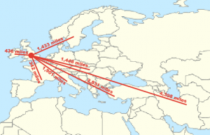
To illustrate just how varied the countries are I created a list of all 15 and found out how many miles from the UK each country is. As some of the locations were listed as just the country, some as cities that have different names in 2020, and others were specific cities, I decided to measure the distance from London to the capital of the nation in question. The list includes:
Europe and the Middle East – France, Ireland, Sweden, Hungary, Italy, Turkey and Iran

Figure 2: The number of miles between London and countries in Europe and the Middle East (Wikimedia Commons 2014; Free Map Tools 2018).
North America and the Caribbean – Canada, United States, and Jamaica

Figure 3: The number of miles between London and countries in North America and the Caribbean (Wikimedia Commons 2014; Free Map Tools 2018).
Asia and Australia – India, Japan, Australia, and New Zealand

Figure 4: The number of miles between London and countries in Asia and Australia (Wikimedia Commons 2014; Free Map Tools 2018).
My favourite part of creating the spreadsheet for UCL Art Museum was recording where the prize winners were from. I enjoyed looking up cities I had never heard of and finding out where they are. It was interesting to consider what those places were like toward the end of the 19th century. As for the international students, I thought about how they would have travelled to London by boat and by train to attend school. It certainly would have been longer and more unpleasant than my seven-hour flight from New York.
References:
Wikimedia Commons (2014) ‘World location map.’ Available at: https://commons.wikimedia.org/wiki/File:World_location_map.svg (Accessed: 29 June 2020).
Free Map Tools (2018). Available at: https://www.freemaptools.com/how-far-is-it-between.htm (Accessed: 29 June 2020).
 Close
Close


