In March 2011, a Mw 9.0 earthquake occurred off the coast of Tohoku in northeast Japan. This earthquake triggered one of the largest tsunamis Japan has ever seen and devastated much of the coast. Three months after this historic event, EEFIT (the Earthquake Engineering Field Investigation Team) began their Tohoku field mission. On the anniversary of this disastrous event, exactly 2 years after the fateful earthquake, BIS (UK Department for Business Innovation and Skills) funded myself and fellow PhD student Melodie Vanderpuye to undertake a brief follow-up mission to preliminarily scope the progress that has been made in rebuilding devastated areas. The week-long mission to Japan involved strengthening UK-Japan links via participation in the 10th International Workshop on Water Dynamics and ICDP Japan Beyond Brittle Project, and the undertaking of a 2-day field mission to tsunami-impacted areas.
Our week in Japan began with a fascinating 3 days at the 10th International Workshop on Water Dynamics and the ICDP Japan Beyond Brittle Project at Tohoku University, Sendai. The conference brought together a wide range of expertise from both the scientific and engineering communities and provided an interdisciplinary forum for the sharing and discussing of ideas.

The conference was not only informative, providing a brilliant insight into the issues I will be encountering during my PhD, but allowed relationships to be forged between industry representatives and the academic world. During our time at the conference meetings were also held with the IRIDeS (International Research Institute of Disaster Science) representative Prof Fumihiko Imamura to discuss the agenda for the upcoming conference at UCL in November 2013, which marks the anniversary of the 150 year relationship between UCL and Japan.
Attending the conference we saw first-hand Japan’s praiseworthy desire to nurture international relationships between industry and academia. The hospitality at Tohoku University was second to non and we were looked after extremely well. The conference banquet at the end of the first day was a particular highlight, even if we were swaying slightly with exhaustion from our 12 hour flight and full conference day without any sleep!
After an enlightening 3 days at the conference it was Melodie and I’s turn to go it alone and explore Japan for ourselves in order to follow up on the EEFIT report compiled 2 years earlier. We also wanted to experience first-hand the impact of such a large magnitude, both in power and impact, event. We hired a car to give us the freedom we needed to explore the planned sites. The field mission began in Sendai and took a coastal route where possible, as certain roads still have not been rebuilt after the tsunami, as far north as Ofunato. With a slight nervous excitement regarding what we were going to find, we set off on Friday 15th March heading north towards the Miyagi Prefecture coastline, one of the worst hit sections of coast in Japan.
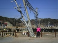
Railway station at Nobiru.
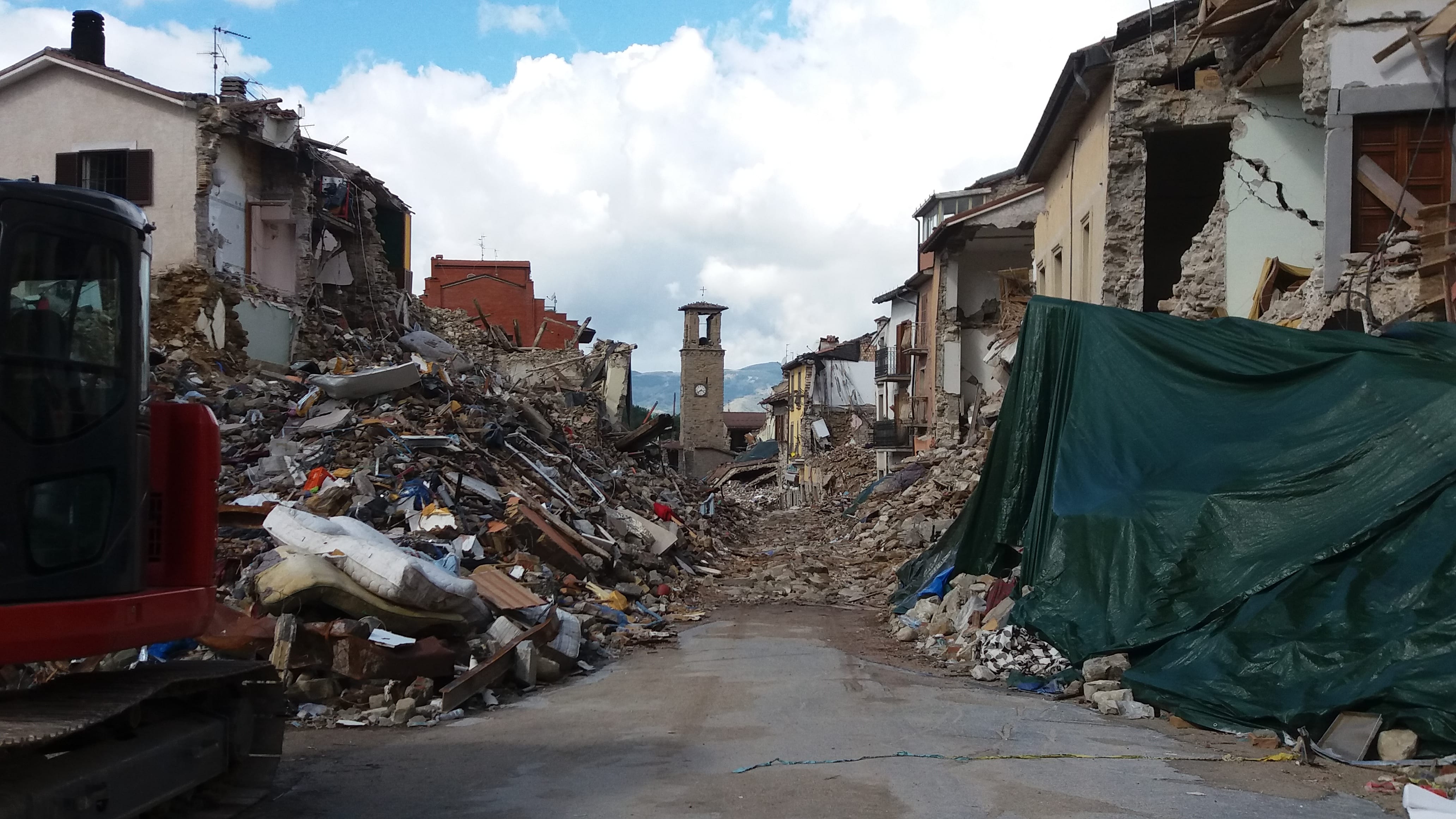
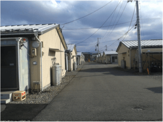
We were immediately struck by the impact of the tsunami at one of our first stops, Nobiru, a small town east of Matsushima. Nobiru showed no signs of redevelopment apart from a few individual residential homes. The tsunami destroyed the town’s railway station, twisting the tracks and overhead power lines and heavily damaging the station building and surrounding shops. The coastal road is still diverted due to unrepaired damage. It appears that due to the town’s lack of industrial prowess and significant strategic importance, redevelopment has not been a priority and the whole area is mostly abandoned. A similar situation was also observed at Wakabayashi on the coast of Sendai. This is an area of near-total devastation. The only new building within this entire area was a temporary structure housing a 7 Eleven convenience store. Wakabayashi was our final site on the last day of our field mission but despite the evidence of destruction we had observed over the previous 2 days, this final site really made the impact of the tsunami hit home. The utter hopelessness and vulnerability of Wakabayashi’s position coupled with the footprints of homes
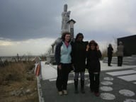
Memorial at Wakabayashi, Sendai.
where living rooms, kitchens, bedrooms and bathrooms were still visible really made us think about the impact of this event on individual families. It is very easy to quote statistics on damage to concrete and steel, and even death toll statistics can become quite meaningless and devoid of emotion when repeated so frequently, but on the ground, stood at the front door of what was once a happy family home, now a mere footprint on the earth, really compounded our belief that something needs to be done to prevent this devastation from occurring to future generations. A memorial stands on the shoreline at Wakabayashi, dedicated to all of the victims of the tsunami.
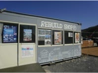
Rebuild Shop at Onagawa
Sites where the outlook was more positive were Onagawa and Shizugawa Bay, which in contrast to Nobiru and Wakabayashi, showed clear signs of progress but had not quite reached the rebuilding stage of recovery. In Onagawa one indicator of the destruction the 16 metre inundation wave wrought on the bay has turned into an unlikely tourist attraction. A 3-storey steel framed, reinforced concrete building was overturned by the force of the water during the tsunami but remained intact. As images of the building have circled the globe and visitors to the area go out of their way to visit the site, the ruin is now being deliberately preserved as a monument and reminder of the power nature can wield. A car park has been cordoned off and a temporary ‘Rebuild Shop’ has sprung up to help raise funds for the redevelopment of the area.

Left: 2011 EEFIT image of Building D; Right: 2013 image.
After a refreshing night in a Japanese style hotel room, complete with slippers, Tatami Mats and a wonderful bento meal, we set out for Ofunato. On entering the town from the south, the redevelopment and rebuilding efforts of the town became apparent. The road (Route 45) appeared newly laid and lining it were newly constructed buildings housing a range of businesses from small enterprises to larger chain stores. The overall impression of Ofunato was one of progress.

Takata-Matsubara
Despite the speedy recovery of certain areas devastated by the 2011 tsunami, there is still a long way to go before the Tohoku coastline of Japan can be classified as recovered from this momentous event. Some may argue that it never can fully recover from such an earth-shattering occurrence. Hope, however, can be seen in the miraculous survival of a singular tree on the shoreline of Takata-Matsubara. Where once 70,000 pine trees stood along a 2 km stretch of beach, one tree was left standing after the 2011 tsunami. This ‘miracle pine’ has captured the hearts of the Japanese people and it is now being preserved as an enduring symbol that hope is not lost and life can be protected.
Throughout our enlightening week in Japan, lots of things were learnt, many sights were seen and much rice was eaten. We all came away with a far greater appreciation of what challenges Japan, and indeed the world, are facing relating to our vulnerability to natural disasters. In addition to this deeper understanding however, Melodie and I also learnt that our transferable skills extend to the operation of an entirely Japanese Sat Nav; the personal achievement of our successful navigation around the coast and arrival back at the car hire shop a mere 10 minutes before the drop off time was, we felt, quite a triumph!
We would like to thank, once again, the UK Department for Business, Innovation and Skills (BIS) for funding the expedition; their support is gratefully acknowledged.
 Close
Close