X Close

The Survey of London

Home

Recording the history of London's built environment since 1894

Menu

Archive for the 'Battersea' Category

Seasons Greetings from the Survey of London

By the Survey of London, on 21 December 2018

Thank you for reading the Survey of London’s blog posts over the last year. Here follows a selection of our favourite wintry photographs from our past and present studies of London. Happy Christmas and all good wishes for the New Year.

Oxford Street

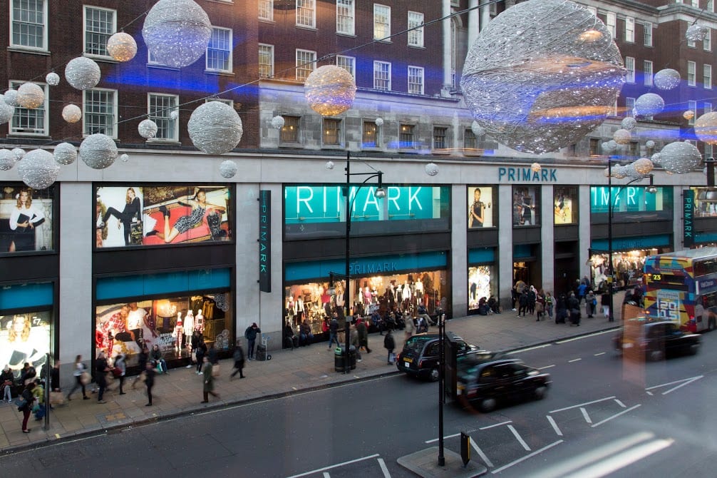
As the longest continuous shopping street in Europe since the eighteenth century, Oxford Street is a unique phenomenon. Though it has witnessed almost continuous change, it has never lost its popularity. The character of Oxford Street is defined above all by its shops, and Christmas is its busiest time of the year. In 2015 we asked Lucy Millson-Watkins to photograph the lights, sights and decorations of Christmas on Oxford Street. Here is a selection of the photographs that she took, first published online in a blog post that considered the festive season on Oxford Street and its enduring traditions. The Survey’s work on Oxford Street is nearing completion, and the volume is expected to be published by Yale University Press, with support from the Paul Mellon Centre for Studies in British Art, in 2020.

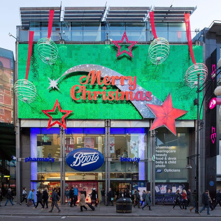
Boots at 385–389 Oxford Street, photographed in December 2015. (© Lucy Millson-Watkins)

West end of Oxford Street looking towards Marble Arch, with Marks & Spencers flagship store. (© Lucy Millson-Watkins)

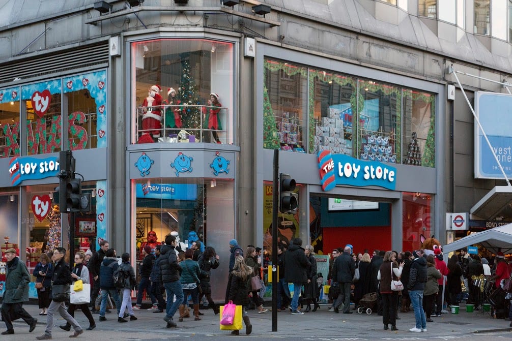
The Toy Store at 381 Oxford Street, a Dubai-based chain which opened its first UK store in 2014 close to Bond Street Station. (© Lucy Millson-Watkins)

Whitechapel

Research is continuing in Whitechapel, a district with a long and rich history, currently in the throes of intense change. One of this year’s highlights for the Survey was the Whitechapel History Fest, which took place at the Whitechapel Idea Store in October. The festival marked the closing stages of the three-year Arts and Humanities Research Council funded research project, ‘Histories of Whitechapel’. Local experts, residents and historians convened to discuss the past and present of Whitechapel, with talks, film, poetry readings and panel discussions.

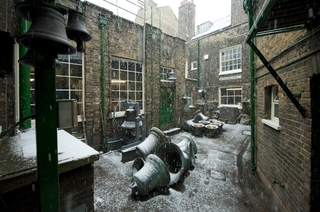
The Whitechapel Bell Foundry, 32–34 Whitechapel Road, in 2010. (© Historic England Archive, photographed by Derek Kendall)

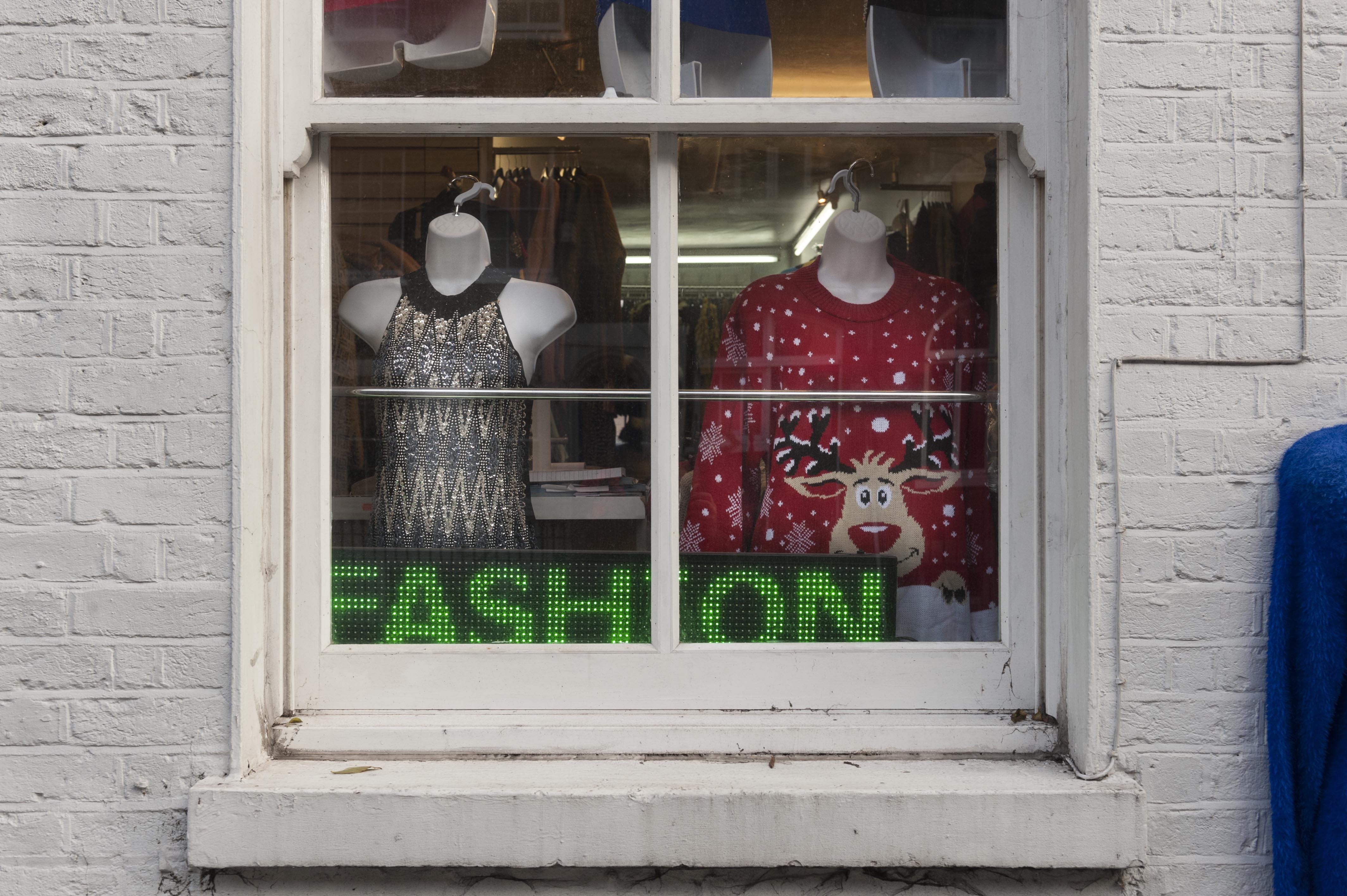
Gee 8 Fashions, 14 New Road, Whitechapel, photographed in November 2018. (© Derek Kendall)

View into vehicle dispatch bay at the East London Mail Centre and E1 Delivery Office, Whitechapel Road, photographed in October 2018. (© Survey of London, photographed by Derek Kendall)

South-East Marylebone

In 2017, two volumes (Nos 51 & 52) were published on South-East Marylebone, covering a large swathe of the parish of St Marylebone. In November 2018, the Survey was honoured to received the prestigious Colvin Prize from the Society of Architectural Historians of Great Britain in recognition of the volumes as an outstanding work of reference on an architectural subject. The draft chapters are available to download via our website, pending a full online version. The Survey is following up these volumes with a study of South-West Marylebone, covering the area west of the boundary of the previous volumes as far as Edgware Road.

17–18 Cavendish Square, view from the east in December 2015. (© Historic England, Chris Redgrave)

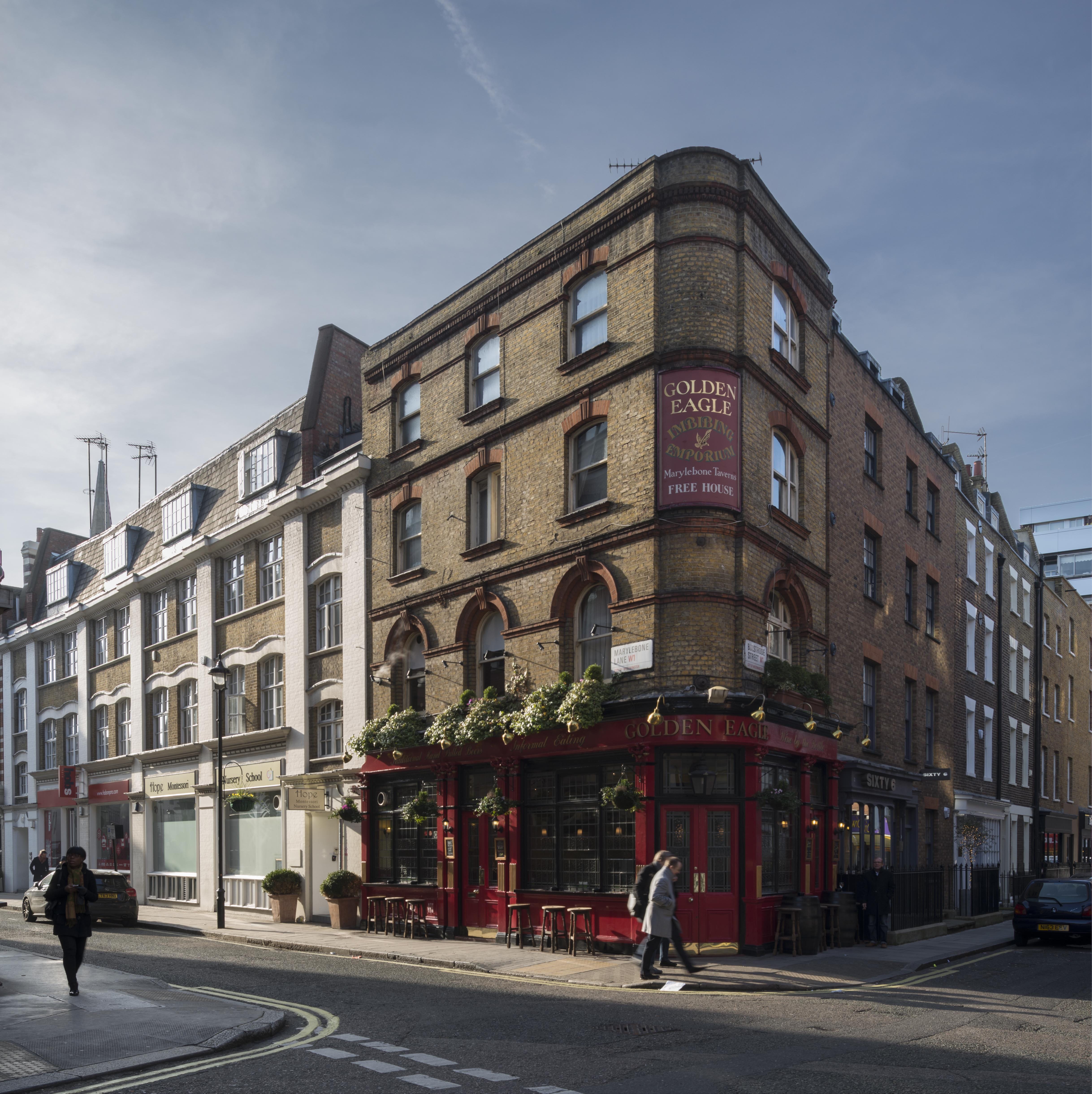
The Golden Eagle Public House, 59 Marylebone Lane, view from the north-east in January 2016. (© Historic England, Chris Redgrave)

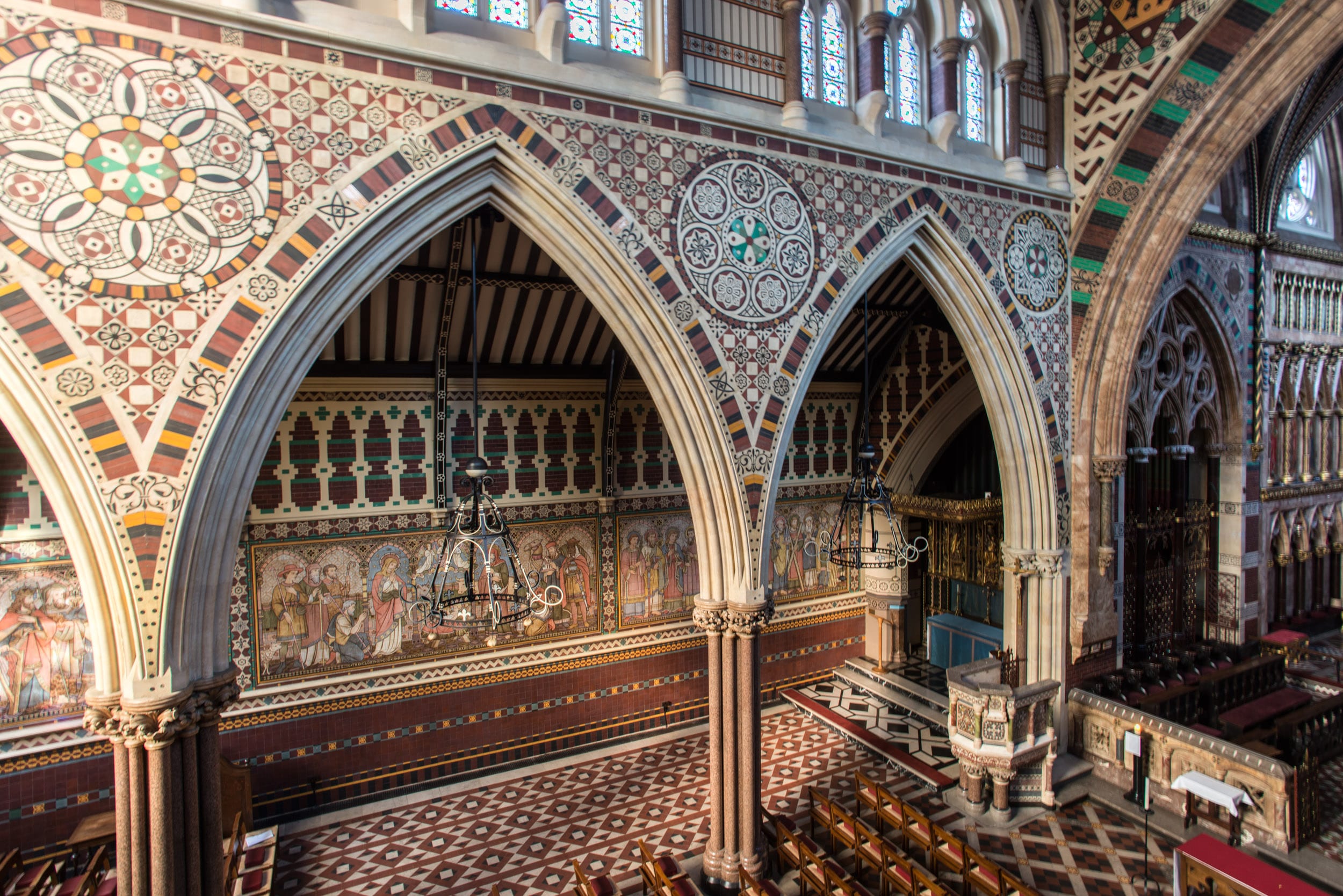
Nativity with six apostles on the lowest row of the reredos at All Saints Church, Margaret Street, South-East Marylebone. The tilework at All Saints was designed by Butterfield, painted by Alexander Gibbs and executed by Henry Poole & Sons. (© Historic England, Chris Redgrave)

Battersea

The Survey completed its work on Battersea in 2013, with the publication of two volumes (Nos 49 and 50) by Yale University Press. The draft texts of all thirty-two chapters from the Battersea volumes are available via our website, prior to the release of a full online version.

Battersea Square, photographed in December 2012. (© Historic England, Chris Redgrave)

Clapham Common under snow in 2013. St Barnabas’s Church on Clapham Common North Side is within view in the distance, its pitched roofs adorned by a dusting of snow. (© Historic England, Chris Redgrave)

Clapham Common under snow in 2013, looking towards towards Clapham Common North Side. (© Historic England, Chris Redgrave)

Woolwich

Finally, 2018 saw the online publication of the Survey’s volume (No. 48) on Woolwich, first published in 2012 and now digitally available here.

Woolwich Covered Market, Plumstead Road, listed in 2018, photographed in 2007. (© Historic England, Derek Kendall)

Mosaic detail from St George’s Garrison Church, Woolwich, photographed in 2007. (© Historic England, Derek Kendall)

Mosaic and painted decoration, St Michael and All Angels Church, Woolwich, reconstruction. (© Historic England, George Wilson)

The Survey of London’s favourite festive photographs

By the Survey of London, on 21 December 2017

Thank you for taking the time to read the Survey of London’s blog posts over the last year. Here follows a selection of our favourite festive photographs from our past and current studies of the capital’s built environment. Happy Christmas and all good wishes for the New Year.

Oxford Street

The character of Oxford Street is defined above all by its shops, and Christmas is its busiest time of the year. In 2015 we asked Lucy Millson-Watkins to photograph the lights, sights and decorations of Christmas on Oxford Street. Here is a selection of the photographs that she took, first published online in a blog post which considered the festive season on Oxford Street and its enduring traditions.

Oxford Street at dusk, looking east. (© Survey of London, Lucy Millson-Watkins)

Christmas bauble decorations strung across Oxford Street in December 2015. (© Survey of London, Lucy Millson-Watkins)

Boots, with understated decoration. (© Survey of London, Lucy Millson-Watkins)

Whitechapel

Last December it was announced that the Whitechapel Bell Foundry would close in May 2017, and this year has witnessed its closure and the end of what has been a remarkable story. Business cards claim the bell foundry as ‘Britain’s oldest manufacturing company’ and ‘the world’s most famous bell foundry’ – the first not readily contradicted, the second unverifiable but plausible. The business, principally the making of church bells, had operated continuously in Whitechapel since at least the 1570s. It had been on its present site with the existing house and office buildings since the mid 1740s. Derek Kendall’s wintry photographs of the bell foundry in 2010 provide an insight into its historic buildings and the preservation of traditional craftsmanship until its closure. If you would like to read the Survey’s full account, please click here to find the draft text on the Survey’s ‘Histories of Whitechapel’ website.

Shopfront at the east end of 32–34 Whitechapel Road in 2010. (© Historic England Archive, photographed by Derek Kendall)

Inner yard of the bell foundry, looking north-west in 2010. (© Historic England Archive, photographed by Derek Kendall)

Tuning shop in 2010. (© Historic England Archive, photographed by Derek Kendall)

University College London

There is a Survey of London monograph on University College London in the offing. UCL’s first architectural expression was the grand neoclassical building constructed in 1827–9 to designs by William Wilkins, its portico and dome a prominent statement. Only the central range of this scheme was completed, yet successive wing extensions have formed a dignified quadrangle in Gower Street.

The Corinthian portico and dome of the Wilkins Building is instantly recognizable and has been adopted by UCL as its logo. (© UCL Creative Media Services, Mary Hinkley)

View of the Wilkins Building from Gower Street, looking east. (© UCL Creative Media Services, Mary Hinkley)

Even the railings in front of the Cruciform Building, formerly University College Hospital, received a generous helping of snow in February 2009. Alfred and Paul Waterhouse’s triumphant red-brick and terracotta hospital was built on a cruciform plan in 1896–1906. (© UCL Creative Media Services, photographed in 2009 by Mary Hinkley)

Battersea

Clapham Common is one of London’s most-prized public spaces, notable for its wide-open character and the clear sense of definition and urbanity imposed by its boundaries. An essentially triangular and uniform area of some 220 acres, it has lost less ground to development than most metropolitan commons. Archery was a popular pastime in the eighteenth century, as were boxing and hopping matches, and occasional fairs which attracted larger gatherings. Today the common boasts a mixture of formal and informal planting, tree-lined roads, sports facilities, play areas, and broad open spaces. The ponds and the bandstand (1890) are notable remnants of improvements effected in the nineteenth century, when cricket, football, tennis, golf, horse riding, model yachting and bathing were all enjoyed on the common. If you would like to read the Survey’s full account of Clapham Common from the Battersea volumes (published in 2013), please click here to download the draft chapter on ‘Parks and Open Spaces’ from our website.

Clapham Common, the north-western panhandle under snow in 2013. St Barnabas’s Church on Clapham Common North Side is within view in the distance, its pitched roofs adorned by a dusting of snow. (© Historic England, Chris Redgrave)

Sledging on Clapham Common in 2013. (© Historic England, Chris Redgrave)

Clapham Common under snow in 2013, view towards Clapham Common North Side. (© Historic Englnad, Chris Redgrave)

South-East Marylebone

The brick church and lofty spire of All Saints, together with the twin clergy and parish buildings that front it towards Margaret Street, comprise a renowned monument to Victorian religion and architecture. Exuberant and compact, the group was built in 1850–2 by John Kelk to designs by William Butterfield, yet the interior of the church with its painted reredos by William Dyce was not completed and opened till 1859. Butterfield continued to embellish and alter All Saints throughout his lifetime, and it is always regarded as his masterpiece. Among decorative changes to the interior since his death, the foremost were those made by Ninian Comper between 1909 and 1916. Recent restorations have reinforced Butterfield’s original vision of strength, experimental colour and sublimity. A full account of this astonishing church has been published in the Survey’s volumes on South-East Marylebone, published in 2017. Please click here to read the account of All Saints’ Church in the Survey’s draft chapter on Margaret Street.

View of All Saints’ Church, Margaret Street from the west. (© Historic England, Chris Redgrave)

North aisle, looking north-east. (© Historic England, Chris Redgrave)

Nativity scene on the wall of the north aisle. The tilework at All Saints was designed by Butterfield, painted by Alexander Gibbs and executed by Henry Poole & Sons in 1875–6. (© Historic England, Chris Redgrave)

Winstanley Estate, Battersea

By the Survey of London, on 29 January 2016

Social housing has been much in the news lately with the Government’s controversial plans to ‘blitz’ what are considered ‘sink’ estates.

‘David Cameron promises to bulldoze Britain’s sink estates’, The Daily Mail, 10 January 2016

‘David Cameron will not be able to redevelop “sink estates” without a fight’, The Guardian, 27 January 2016

One of those said to be earmarked for redevelopment is the Winstanley Estate, north of Clapham Junction, considered a model of its kind when it went up, mostly in the early to mid-1960s. In fact the area involved includes the slightly later York Road Estate which is likely to be entirely rebuilt, following consultation between Wandsworth Council and local residents.

© Historic England, Chris Redgrave

Winstanley Estate, looking north-west from Thomas Baines Road towards Clark Lawrence Court in 2012 (© English Heritage, Chris Redgrave). If you are having trouble viewing images, please click here.

Survey Of London, Battersea, Winstanley Estate, Thomas Baines Road, Battersea, London. General view of housing estate. © Historic England, Chris Redgrave

Winstanley Estate, Thomas Baines Road, photographed in 2012 (© English Heritage, James O. Davies).

The history of the area, its Victorian prehistory of small terraced houses as well as the colourful evolution of the Winstanley and York Road estates from the 1950s to the 1970s were covered in detail in the Survey of London’s volume 50 on Battersea housing (2013). Its assessment generally draws out the relative merits of the Winstanley, with its ‘coherence of design lacking in any other post-war housing built in Battersea’, which is likely to be refurbished, and the ‘uninspired’ York Road with its ‘bulky monotony’, which is to be demolished:

Chapter 8: North of Clapham Junction, draft chapter of Survey of London Volume 50

Survey Of London, Battersea volume. Winstanley Estate, Thomas Baines Road, Battersea, London. General view of Clarke Lawrence Court. © Historic England, JD

Clark Lawrence Court in the Winstanley Estate, photographed in 2012 (© English Heritage, James O. Davies).

York Gardens Pennethorne House London SW11

York Gardens and Pennethorne House, York Road Estate Stage 1, photographed in 2011. Pennethorne House is one of the blocks that is likely to be demolished (© English Heritage, Nigel Corrie).

Though now perhaps best known outside Battersea as the home of garage and hip hop band So Solid Crew, the Winstanley has also provided a filming location for a number of feature films, notably Poor Cow (1967), Ken Loach’s first full-length film as a director, and the Oliver Reed thriller Sitting Target (1972). The Survey was involved with the architecture departments at Cambridge and Liverpool in 2012-13 in a research project called Cinematic Geographies of Battersea. Taking its cue from Jonathan Raban’s 1974 book Soft City, the project explored the different ways that urban histories, such as the Survey, and filmmakers, present the city, whether as the ‘hard city’ found in statistics and maps, or the ‘soft city’ found in the suggestive discontinuities of film. One outcome was a short film about the Winstanley that mixes a voiceover taken from edited Survey of London text about the Winstanley, with archive photos and film clips of the Winstanley, both from newsreel and feature films, to suggest that these hard and soft cities are on a continuum, and not that one is ‘more real’ as Raban suggested, than the other.

The Winstanley Plays Itself by Aileen Reid on Vimeo.

Survey Of London, Battersea, Winstanley Estate, Thomas Baines Road, Battersea, London. Detail of mosaic.

Thomas Baines Road, Winstanley Estate, concrete mural of 1963-5 by William Mitchell & Associates, photographed in 2011 (© English Heritage, James O. Davies).