X Close

UCL IRDR Blog

Home

UCL Institute for Risk and Disaster Reduction

Menu

New paper on segmented normal fault systems

By Joanna P Faure Walker, on 19 June 2019

Publication of: Occurrence of partial and total coseismic ruptures of segmented normal fault systems: Insights from the Central Apennines, Italy by Iezzi et al. (2019)

Francesco Iezzi (PhD student, Birkbeck) together with Prof Gerald Roberts (Birkbeck), Dr Joanna Faure Walker (IRDR) and Ioannis Papanikolaou (Agricultural University of Athens) have published a detailed study of the long-term displacements across the fault responsible for the 2009 L’Aquila Earthquake, Italy, and the surrounding faults. This reveals that the different faults are behaving together so that the displacement across the system of faults looks similar to if it were one larger fault on ten thousand and million year timescales. This finding can help provide clues regarding the relative local seismic hazard between the different fault segments. The study also provides evidence that the vertical displacement (throw) across a fault increases across fault bends, a result that has been demonstrated in previous papers by the research group (e.g. Faure Walker et al., 2009; Wilkinson et al., 2015, Iezzi et al., 2018). The Iezzi et al. (2019) paper discusses the synchronised and geometrically controlled activity rates on the studied faults in terms of the propensity for floating earthquakes, multi-fault earthquakes, and seismic hazard.


Photograph of damage following the 2009 L’Aquila earthquake, taken by Joanna Faure Walker while accompanying the EEFIT mission.

More data needed for better earthquake hazard and risk calculations

By Joanna P Faure Walker, on 6 November 2018

New research demonstrates the importance of having detailed measurements at multiple sites along a fault of how fast the fault is moving and how the surface orientation of the fault changes. To access the full paper click here.

Why do we need fault measurements?

Measurements of fault slip rate and the geometry of the fault (it’s 3d orientation) can be used to calculate earthquake recurrence intervals to give probabilities of how likely earthquakes of different magnitudes are to occur. We also need these measurements to model how much ground shaking there will be at given locations. Hazard maps of expected ground shaking can be used to inform building codes and identify where buildings including homes and schools might need retrofitting to improve their resistance to earthquake shaking.

There are other methods available for creating earthquake hazard maps, such as using historical records of earthquake shaking. However, these records unlikely go back far enough in time to capture all faults capable of hosting large earthquakes because some faults will not have hosted earthquake within the time period covered by such records. Therefore, the hazard from some faults would be missing in hazard maps based solely on historical seismicity leading to underestimations in earthquake hazard.

What new insights have been revealed in the research publication?

The paper, entitled “Variable fault geometry suggests detailed fault slip rate profiles and geometries are needed for fault-based probabilistic seismic hazard assessment (PSHA)” demonstrates that relying on only one or a few measurements of how fast the fault is moving along a fault and projecting these measurements along the entire fault may lead to underestimating the uncertainty in the earthquake hazard calculations. Crucially, there may be locations where the hazard is underestimated, meaning people could be at more risk than suggested by simpler models (the converse is also possible). Therefore, earthquake hazard assessments based on fault parameters need to either use detailed measurements including measurements of how fast the fault is moving at multiple sites along the fault or to incorporate how the lack of such data increases the uncertainty in calculated earthquake hazard assessments.

Why are detailed measurements not being already used?

In many regions it is difficult to constrain the fault slip rate (how much the fault has moved in a given time) or throw rate (vertical component of slip rate) along a fault at even one location, let alone several. However, there are regions where this is possible so as more data is collected, this detail should help to improve earthquake hazard assessments both in those regions and worldwide.

Where can I find out more?

Faure Walker J., Visini F., Roberts G., Galasso C., McCaffrey K., and Mildon Z., (2018) Variable fault geometry suggests detailed fault slip rate profiles and geometries are needed for fault-based probabilistic seismic hazard assessment (PSHA), Bulletin of the Seismological Society of America, doi: 10.1785/0120180137

The Fault2SHA Working Group is an ESC (European Seismological Commission) group of researchers in both universities and civil protection authorities collaborating to increase incorporation of fault data in seismic hazard assessments and to improve our understanding of how such data should be used.

Fault2SHA has successful session at ESC 2018 in Malta

By Joanna P Faure Walker, on 7 September 2018

The Fault2SHA ESC (European Seismological Commission) Working Group hosted a session on Wednesday 5th September at the ESC 2018 Meeting held in Valletta, Malta. Oona Scotti represented the group in her keynote on the opening day of the conference, in which she addressed “Modelling fault systems in PSHA: Challenges Ahead”. The Fault2SHA Working Group, for which I am on the Executive Committee, links different researchers working on faults and seismic hazard assessment (SHA) in Europe and beyond. This collaboration has brought together field geologists, fault-modellers and probabilistic seismic hazard modellers. The group provides a forum in which data, results, modelling capabilities, and improvements in scientific understanding can be shared. If you want more information, and to join, see Fault2SHA. The next Fault2SHA workshop will be in Kaust, Saudi Arabia, in November 2018 and the next meeting will run on 3rd-5th June 2019 in Barcelona, Spain.

I lead the Fault2SHA Central Apennines Laboratory. Our team comprises researchers from Italy (Paolo Boncio, Bruno Pace, Laura Peruzza, Francesco Visini), France (Lucilla Benedetti, Ooona Scotti) and the UK (Joanna Faure Walker, Gerald Roberts). At ESC in Malta, I introduced the central Apennines Laboratory and our current activities to the wider working group. The Central Apennines, as well as being a beautiful place to conduct fieldwork with the opportunity to obtain detailed datasets, suffers from large magnitude earthquakes. Indeed, earthquakes in the Central Apennines have featured widely in the UK press due hosting the two deadliest earthquakes in Europe of the last ten years: the 2009 L’Aquila sequence and the 2016 Amatrice-Norcia sequence.


The Fault2SHA Central Apennines Laboratory, which formed in January 2018, held an in-person meeting in July at the University of Chieti-Pescara, Italy. The photograph shows (from left to right) Oona Scotti, Francesco Visini, Joanna Faure Walker, Bruno Pace, Laura Peruzzi, Lucilla Benedetti, and Paolo Boncio.

During the Fault2SHA ESC session, I presented a second talk and a poster about my research investigating the importance of incorporating detailed fault geometry for understanding seismic hazard. The oral presentation demonstrated the importance of incorporating detailed fault geometry and loading on faults between earthquakes in Coulomb Stress Transfer modelling, a process that causes the stress on faults to change in response to an earthquake on a neighbouring fault. This was based on work carried out by Zoe Mildon (former IRDR PhD student, now a lecturer at the University of Plymouth) in collaboration with Gerald Roberts, Shinji Toda and myself (see Midon et al. 2016 and Mildon et al. submitted preprint). The poster displayed the importance of detailed fault geometry and slip-rate data for calculating earthquake probabilities and ground shaking intensities. I further represented Zoe for her poster within the session on earthquakes in regions of distributed deformation, that showed surface ruptures from the 1997 Colfiorito Earthquake in the central Apennines was due to primary earthquake slip (see Mildon et al., 2016 for details).

I thank all those at the conference with whom I had interesting discussions and I look forward to seeing all of our research progress.

IRDR Masters student publishes Early Warning and Temporary Housing Research. This is part of the on-going collaboration between UCL-IRDR and IRIDeS-Tohoku University

By Joanna P Faure Walker, on 4 June 2018

Angus Naylor, an IRDR Masters student alumni and Masters Prize Winner, has published the research conducted for his Independent Research Project. The research was carried out as part of his MSc Risk, Disaster and Resilience with me, his project supervisor, and our collaborator at Tohoku University IRIDeS (International Research Institute of Disaster Science), Dr Anawat Suppasri.

Following the Great East Japan Earthquake and Tsunami in 2011, UCL-IRDR and Tohoku University IRIDeS wanted to join forces to learn more about both the fundamental science and impacts of disasters both in Japan and around the world. Naylor’s recently published paper adds to other collaborative outputs from the two institutes: Mildon et al., 2016, investigating Coulomb Stress Transfer within the area of earthquake hazard research; Suppasri et al., 2016 investigating fatality ratios following the 2011 Great East Japan Tsunami; and IRDR Special Report 2014-01 on the destruction from Typhoon Yolanda in the Philippines. The two institutions have met on a number of occasions, and have an upcoming symposium in October 2018.

In 2014, three and half years after the Great East Japan Earthquake and Tsunami destroyed much of Tohoku’s coastline, I led and Dr Anawat Suppasri organised a joint UCL-IRDR and Tohoku University IRIDeS team, visiting residents of six temporary housing complexes in Miyagi and Iwate prefectures. While there, we used written questionnaires and informal group interviews to investigate the suitability of early warning systems and the temporary housing among the elderly population affected by this event.

When analysing the results, we found overall that age was not the principal factor in affecting whether a warning was received, but did play a significant role regarding what was known before the warning was received, whether action was taken and how temporary and permanent housing was viewed. The results suggest that although the majority of respondents received some form of warning (81%), no one method of warning reached more than 45% of them, demonstrating the need for multiple forms of early warning system alerts. Furthermore, only half the respondents had prior knowledge of evacuation plans with few attending evacuation drills and there was a general lack of knowledge regarding shelter plans following a disaster. Regarding shelter, it seems that the “lessons learned” from the 1995 Kobe Earthquake were perhaps not so learnt, but rather many of the concerns raised among the elderly in temporary housing echoed the complaints from 16 years earlier: solitary living, too small, not enough heating or sound insulation and a lack of privacy.

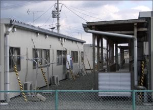
An example of Temporary Housing following the Great East Japan Earthquake and Tsunami visited during the fieldwork for this study (Photograph: Dr Joanna Faure Walker)

The research supports previous assertions that disasters can increase the relative vulnerabilities of those already amongst the most vulnerable in society. This highlights that in order to increase resilience against future disasters, we need to consider the elderly and other vulnerable groups within the entire Early Warning System process from education to evacuation and for temporary housing in the transitional phase of recovery.

The paper, ‘Suitability of the early warning systems and temporary housing for the elderly population in the immediacy and transitional recovery phase of the 2011 Great East Japan Earthquake and Tsunami’ published in the International Journal of Disaster Risk Reduction, can be accessed for free until 26th July here, after this date please click here for standard access.

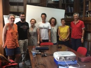
The authors are grateful for the fieldwork funds which came from The Great British Sasakawa Foundation funding to UCL-IRDR and MEXT’s funding to IRIDeS. The joint UCL-IRDR1 and IRIDeS2 fieldwork team comprised Joanna Faure Walker1, Anawat Suppasri2, David Alexander1, Sebastian Penmellen Boret2, Peter Sammonds1, Rosanna Smith1, and Carine Yi2.

Angus Naylor is currently doing a PhD at Leeds University
Dr Joanna Faure Walker is a Senior Lecturer at UCL IRDR
Dr Anawat Suppasri is an Associate Professor at IRIDeS-Tohoku University

Roots of earthquake-prone faults brought to light

By Joanna P Faure Walker, on 25 November 2013

Earthquakes affect many highly populated areas around the world so understanding what controls the distribution and frequency of them is a top priority for the earth science and disaster risk reduction communities. Often, however, the controlling factors remain elusive because scientists have limited information about what happens deep down in the Earth’s crust where earthquakes initiate. A recent Nature Geoscience article (Cowie et al. (2013) published online on 3rd November, 2013) has shed light on the problem, and has shown how phenomena on the surface can be linked to the movement of rocks in the deep crust.

(more…)