X Close

The Bartlett Development Planning Unit

Home

Collective reflections about development practice and cities

Menu

How and in what ways can local-level risk information about health and disasters influence city government practices and policies?

By Cassidy A Johnson, on 28 February 2019

This blog is the fourth of the health in urban development blog series. View also:

Treat, contain, repeat: key links between water supply, sanitation and urban health
By Pascale Hofmann

Health in secondary urban centres: Insights from Karonga, Malawi
By Don Brown

Gaza: Cage Politics, Violence and Health
By Haim Yacobi


If you are interested in DPU’s new MSc in Health in Urban Development, more information can be found on our website.


Over the last few years there have been several initiatives to develop practical and policy-relevant ways to measure environmental risks faced by low-income groups. This has been in response to a severe lack of information about disaster and health risks available for policy makers to draw on in most low- and middle-income nations. There is a need for both detailed settlement-level data, particularly for informal settlements, as well as for aggregated data needed to inform city-level or national interventions[i]. In this blog, I discuss innovative methodologies that are being developed in cities of the Global South to generate much needed data for action.

Innovative methodologies for understanding health and disaster risks at the urban scale

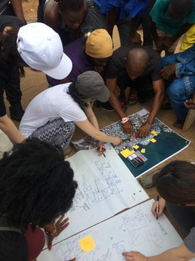
Innovative methods developed for understanding and measuring these risks range from profiling and mapping informal settlements with community-led or co-production approaches, to detailed analysis of hospital, police and newspaper records. Other methods seek to build consensus based on perceptions and experiences of risk with communities and local governments. DesInventar is a collection of national, regional and city-level databases, which use newspaper reports, as well as police, hospital and accident records to create a detailed portrait of both large or intensive disasters and small-scale extensive disaster events. Other methodologies such as Slum/Shack Dwellers International (SDI) settlement profiling and Action at the Frontline use community-generated information about resident’s experiences of health and disaster risks in order to enter into dialogue with municipal governments about their needs. ReMapRisk uses community-generated risk information and offers a spatial analysis with maps to interrogate and visualise the information, there are maps for Lima (Peru), Karonga (Malawi) and Freetown (Sierra Leone).  Other approaches, such CityRAP, The City Resilience Index and 10 Essentials for Making Cities Resilient focus on the municipal government’s perspectives of risks and capacities for addressing risk at the city-level, and often in dialogue with communities.


Health and disaster risks faced by the urban poor

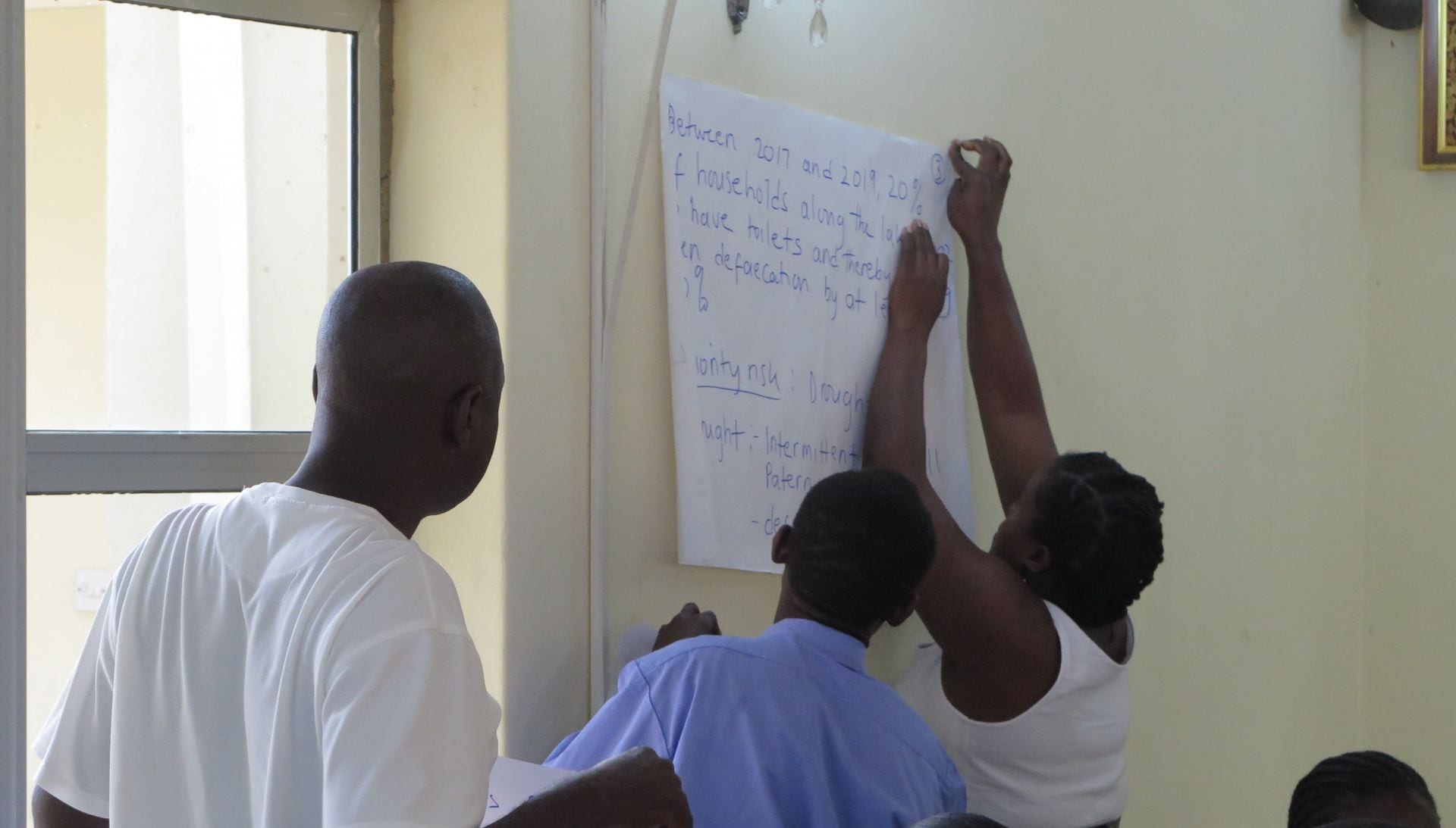
These studies have found that women, men and children living in informal settlements are disproportionally exposed to small and large-scale disaster risks such as flooding, landslides and fires, as well as everyday risks, such as water borne illnesses and poor air quality. For example, the AXA-funded research I have been involved in in Dar es Salaam in Tanzania, used Action at the Frontline methodology, with household surveys, focus groups and action planning Mtambani settlement in Ilala municipality and Bonde la Mpunga settlement in Kinondoni municipality[ii]. The communities identified crime, poor solid management, lack of storm-water drainage infrastructure, lack of wastewater and toilet infrastructure, lack of basic health services and hospitals, flooding, high living costs and drug abuse as the main issues in their settlements. Many of these are directly related to health problems, such as malaria, diarrheal disease and personal safety. While big disasters, such a major floods, earthquakes, tsunami and windstorms do affect the health and welfare of millions across the globe every year, it is actually the smaller events and everyday risks that impact the greatest number of people’s health and well-being.


These different methods of understanding risks have been employed in close partnerships between researchers, community organisations, municipal authorities and other research users in many cities across Asia, Africa and Latin America. While there are many innovative initiatives for understanding and measuring risks, the data still remains extremely patchy and limited in scope. Furthermore, and its uptake into municipal government operations and planning is not guaranteed.


Principles for the uptake of risk information in urban planning and policy making

Through the Urban Africa Risk Knowledge programme[iii], researchers have identified some principles related to the uptake of local-level risk information into planning and policy making: 1) It is important not just to provide the type of information that are assumed to be useful, but to work closely with partners in identifying data that will be useful for policy and practice[iv]. 2) The community-driven process can be more conducive to driving change in practice and policy in local government than expert-driven data. The use of local knowledge that comes through communities collaborating with local level decision-makers can capture the qualitative experiences of risks and measure the burdens arising from these risks, while enabling communities to engage with local governments/state about their needs[v]. 3) Small steps at collecting local data that are ‘good-enough’ can be valuable in the beginning.[vi] 4) Project-based risk measurement initiatives are rarely enough to make a difference in government practices and policies. What is required is long-term and sustained engagement with information that is regularly updated. 5) Improving official data collection, such as census, vital registration systems and healthcare records will be necessary to systematically address disaster and health risks in informal settlements[vii].


Many cities in low- and middle- income countries, and especially in sub-Saharan Africa, do not have functioning local governments, they lack a metropolitan structure or their resources are too meagre to take on new initiatives. While some progress has been made in developing methodologies that help us to better understand the everyday and small-scale disaster risks that underpin women’s, men’s and children’s health in informal settlement, there is still much more to do to scale up these initiatives and to enable local governments to take actions to address risks.


References

[i] Satterthwaite, D and Sverdlik, A (2018). Assessing health risks in informal settlements in sub-Saharan African cities. Urban Africa Risk Knowledge Briefing, No. 10. June 2018. Available from: https://www.urbanark.org/assessing-health-risks-informal-settlements-sub-saharan-african-cities

[ii] Osuteye, E. at al. (2018). Communicating risk from the frontline: projecting community voices into disaster risk management policies across scales. Urban Africa Risk Knowledge Briefing, No. 19. October 2018. Available from:

[iii] See www.urbanark.org

[iv] Dodman, D., Leck, H. and F. Taylor (2017). Applying multiple methods to understand and address urban risk. Urban Africa Risk Knowledge Briefing, No. 7. July 2017. Available from: https://www.urbanark.org/applying-multiple-methods-understand-and-address-urban-risk

[v] Osuteye, E. at al. (2018). Communicating risk from the frontline: projecting community voices into disaster risk management policies across scales. Urban Africa Risk Knowledge Briefing, No. 19. October 2018. Available from: https://www.urbanark.org/communicating-risk-frontline-projecting-community-voices-disaster-risk-management-policies-across

[vi] Spaliviero, M. at al. (2019). Urban Resilience building in fast-growing African Cities. Urban Africa Risk Knowledge Briefing, No. 20, January 2019. Available from: https://www.urbanark.org/urban-resilience-building-fast-growing-african-cities

[vii][vii] Adelekan, I.O. and D. Satterthwaite (2019). Filling the data gaps on everyday and disaster risks in cities: The case of Ibadan. Urban Africa Risk Knowledge Briefing, No 22. January 2019. Available from: https://www.urbanark.org/filling-data-gaps-every-day-and-disaster-risks-cities-case-ibadan

Living at risk in Freetown

By Adriana E Allen, on 4 May 2018

Authors: Leong, Matilda; Vo, Son Nam; Kim, Hayeon; Korsi Simpson, Paul; Korsi Simpson, Peter and Allen, Adriana (Cockle Bay Group from the ESD MSc practice module)

In the early hours of Wednesday, 25 April 2018, the residents of Kola Tree in Cockle Bay were awakened to the shouts of fire. The blaze took place in the informal settlement located in the Western coast of Freetown and affected 97 people. Although there were no casualties reported, rampant loss of property, possessions and livelihoods were claimed by the incident.

When the team from Development Planning Unit (DPU) at University College London (UCL) and Sierra Leone Urban Research Centre (SLURC) arrived at the site, they were met with chaos. A crowd of residents were still dealing with the aftermath of the fire over the rubbles of their corrugated metal sheet homes. Despite all effort to mitigate damages, the flames had been eventually extinguished by burying them under the collapsing building structures.

Photo by S.N. Vo

It was soon established that the Cockle Bay community was left on its own to undertake responsive actions. There were minimal external interventions save for the fire brigade who attempted to extinguish the fire alongside the residents. The DPU/SLURC team quickly came to the support of the residents by conducting an enumeration process to determine who was affected and what was the impact of the fire.

This information was subsequently handed to the local leader of the Federation of the Urban and Rural Poor (FEDURP) and of the Community Based Disaster Risk Management Committee to facilitate the provision of relief for victims and temporary shelter for the night. While the source of the fire was yet to be determined, the rapid assessment conducted by partners on the ground speculated the possibility of an electrical fault. The Office of National Security (ONS) responded hours after the event and is reportedly conducting a more detailed assessment to identify the origin of the fire.

DPU team supporting the enumeration of those affected by fire in Cockle Bay. Photo by A. Allen.

The absence of external support during small-scale disasters is not unusual for informal settlements. In most circumstances, external actors such as governmental institutions and non-governmental organisations have to conserve their limited resources. Consequently, they can only respond to severe incidents. For example, a prominent local NGO was only able to support 144 of the 2,048 victims during the 2015 fire in Susan’s Bay due to the lack of funding. Minor disasters such as that in Cockle Bay accordingly tend to be overlooked and underreported. Moreover, dismal planning characterised by limited road access and dispersed and insufficient water sources also hinder evacuation and relief efforts and exacerbate the everyday risks facing local communities. Moreover, although preliminary relief is given to the victims of disasters, this is often insufficient to ensure that those affected can recover from such events, let alone to escape risk accumulation and poverty cycles.

It is estimated that about 547 fires outbreaks affected those living in informal settlements in Freetown between 2011 to 2015 (Di Marino et al, 2018). Fires are only one of the multiple hazards facing poor and impoverished women and men in the city on a regular basis. Other hazards include floods, mudslides, landslides, waterborne diseases, and occupational hazards, amongst others. Each of these disasters, small and large-scale, disproportionately impact the urban poor – destroying their housing, disrupting their education and in some case, even terminating their sources of livelihood.

Photo by S.N. Vo

The fire outbreak in Cockle Bay brings to light the broader issue of prolonged systematic oversight of informal settlements and the invisibility of certain segments of the city population, such as tenants. As the fire was confined to a mere 8 compounds within a small area of about 100m2, initial estimates speculated that about 20 people had being affected. However, the enumeration process conducted by the team in collaboration with local residents revealed that it was in fact a total of 97 people, a third of whom were children. About 80% of the victims were tenants. This yields an abrupt indication of how vulnerable groups such as tenants and the youth in households are often inadvertently not accounted for, leaving them virtually invisible by the community themselves in times of disasters.

Lacking the means to enter the housing and land markets elsewhere in the city, many women in men are forced to reside in informal settlements like Cockle Bay. Therefore, these areas have experienced consistent densification and land reclamation over the years, particularly since the Civil War. Aside from high housing densities, most informal settlements also face scarce provision of basic services. Communities are forced to utilise improvised infrastructures, causing overloading of electrical points. In the area affected by the blaze, all 34 families relied on two metered connections for electricity.

Everyday life in Cockle Bay. Photo by: A. Allen

Some might posit that informal settlements are hazards in themselves and ought to be eradicated. However, these settlements house a sizeable proportion of Freetown’s population, with no alternative dwelling options. Moreover, their residents perform jobs that support the daily functioning of Freetown; quietly they run the city. Demolishing their living quarters as a ‘protective measure’ against risk simply displaces the issue – disrupting lives, livelihoods, family ties and social organisations – making poor women and men even more invisible. Events like the fire in Cockle Bay remind us of the need to stop blaming the victims and victimising the poor, the need to acknowledge that they live at risk not as an exception but as a common reality, the need to seek pathways for more inclusive urbanisation beyond risk.


Reference

Di Marino, Marco; Lacroix, Lea; Nastoulas, Illias; Simpson, Paul; Trintafillides, Georgina; Williams, Cai Anwyl ; and Yang, Deyu. (2018) Urban Risk Trap: Fire Dynamics in Freetown’s Informal Settlements. Policy Brief No. 2. SLURC/DPU Action-Learning Alliance.


Multiple Dimensions of Risk in Lima

By Christopher Yap, on 4 May 2014

Every year students from MSc Environment and Sustainable Development at the Development Planning Unit embark on a fieldtrip to a country in the global South. Supported by prior research, the fieldwork synthesises hands-on experience with the skills, concepts, and theories of environmental justice for development.

This year the research aims to understand the relations between water, risk and urban development in Lima, Peru, and how environmental injustices are produced and can be addressed, by exploring scenarios and strategies embedded in the wider socio-political, economic and ecological processes, with the potential for transformative change.

Four case studies: Cantagallo, Barrios Altos, Jose Carlos Mariátegui and Huaycán were chosen with our local partners and offer unique readings of Lima.

The first days of fieldwork have started to reveal the complex structural conditions producing and reproducing social-spatial inequalities and precarious living conditions for citizens of Barrios Altos and Cantagallo in the centre of Lima.

A vacant plot in Cantagallo where the former residents accepted LAMSAC's offer of money to vacate the site immediately (c) Chris Yap

A vacant plot in Cantagallo where the former residents accepted LAMSAC’s offer of money to vacate the site immediately (c) Chris Yap

In Cantagallo, multiple groups, such as the indigenous Shipibo community, live in a high density settlement, directly on top of a former city dump-site. The entire district is marked for regeneration, and the community is engaged in long negotiations with the municipal authorities over their relocation. However the private company, LAMSAC, working in partnership with the municipality to manage the infrastructure megaproject, Via Parque Rimac, is also offering money to families to vacate their plots immediately. Some members of the community have already left their improvised properties, which were immediately demolished and the plots fenced off, to prevent others from taking their place.

For every family that vacates their plot during talks with the municipal authorities, the negotiating position of the remaining families is weakened. Those families that remain face a multitude of socio-environmental risks; unhygienic living conditions and tenure insecurity the most apparent.

In Barrios Altos, only a few hundred metres away from Cantagallo, residents face a different set of challenges and risks. The historic centre of Lima is characterised by its grand, dilapidated buildings. The current residents of the quintas – colonial-era buildings some of which have lived in the area for generations and others that are new to the district, face daily risks from unstable, unsafe structures, land trafficking and forced displacement.


Buildings at risk of collapse in Barrios Altos (c) Chris Yap

Buildings at risk of collapse in Barrios Altos (c) Chris Yap

The central location and cultural significance of the district and the quintas has attracted multiple actors with competing intentions for the area’s regeneration. Private sector developers and municipal agencies, such as ProLima, are being pushed to find new solutions for urban regeneration.

The displacement or relocation of residents from the grand buildings is followed by the barricading of the room or building, just as the vacant plots are fenced off across the river in Cantagallo.

A bricked-up former residence in Barrios Altos (c) Chris Yap

A bricked-up former residence in Barrios Altos (c) Chris Yap

Meanwhile, many local private developers are building illegally, without permits, behind the UNESCO-protected facades of the quintas. But whilst the municipal authorities are aware of the problem, they lack the capacity to prevent the developments.

Of greater concern are the cases where private developers have forcibly evicted tenants, or cut water pipes to hasten the collapse of the already fragile buildings in order to acquire the land for development.

The complex reality generated by multiple actors with different interests, capacities, resources and priorities, and multi dimensional realities of risk, are manifested differently in each of the two sites, yet the residents face comparable challenges. Over the next two weeks, students will explore the nature of risk in each of the sites, and the strategies that residents and other stakeholders are adopting to challenge inequitable urban development.

A quinta where the water pipes were illegally cut, forcing the residents to leave and causing the structure to collapse. (c)  Chris Yap

A quinta where the water pipes were illegally cut, forcing the residents to leave and causing the structure to collapse. (c) Chris Yap